[Thread Prev][Thread Next][Index]
Re: plane rotation
Hi all,
Part II. The rotated output grid is really a rectangular grid, it just
does not follow constant lines of longitude and latitude. So we can put
the rotated data onto an x-y grid, and not have to deal with it in
curvilinear coordinates. Think of the equator. In the lat-lon grid
it's a set of points with varying longitude and constant latitude. In
the rotated grid both the longitude and latitude coordinates vary. We
can use the SAMPLEXY function to get the values of the data field at
that set of longitudes and latitudes. We can do this for all the points
on the 2-D grid. Then create the output, rotated grid in terms of index
space, I and J (abstract X and Y axes). In out map projection script,
we have units of radians, so I'll do the samplexy on the data in radians.
First, the rotate script needs the parameters central_meridian and
standard_parallel so it will work for data on any part of the globe.
!++++++++++++++++++++++++++++++++++++++++++++++++++++++++++++++++++++++++++++!
\ cancel mode verify
! mp_rotate.jnl -- Sets up variables for a Rotated projection using
! 'curvilinear coordinates' code in Ferret v4.50
!
! Ansley Manke 4/28/05
! based on other map projection scripts
! Description: Sets up variables for a Rotated map of the world
!
! Usage:
! go mp_rotate angle [central meridian] [standard_parallel]
!
! arg 1 - angle to rotate from horizontal X axis, in degrees
! arg 2 - longitude used for the center of the projection,
mp_central_meridian
! arg 3 - latitude used for the center of the projection,
mp_standard_parallel
! Example:
! use coads_climatology
! go mp_rotate 30
! set grid sst
! shade/noaxis sst[l=1], x_page, y_page
!
let/quiet mp_x = x
let/quiet mp_central_meridian = $2%(mp_x[i=@max] + mp_x[i=@min])/2%
let/quiet mp_y = y
let/quiet mp_standard_parallel = $3%(mp_y[j=@max] + mp_y[j=@min])/2
% ! ???
let/quiet Pi = 3.14159265
let/quiet deg2rad = Pi / 180.0
let/quiet mp_R = $1* deg2rad
let/quiet mp_lambda0 = mp_central_meridian * deg2rad
let/quiet mp_phi0 = mp_standard_parallel * deg2rad
let/quiet mp_lambda = mp_x * deg2rad - mp_lambda0
let/quiet mp_phi = mp_y * deg2rad - mp_phi0
let/quiet x_page = mp_lambda* cos(mp_R) - mp_phi* sin(mp_R)
let/quiet y_page = mp_phi* cos(mp_R) + mp_lambda* sin(mp_R)
let/quiet mp_mask = 1
set mode/last verify
!++++++++++++++++++++++++++++++++++++++++++++++++++++++++++++++++++++++++++++!
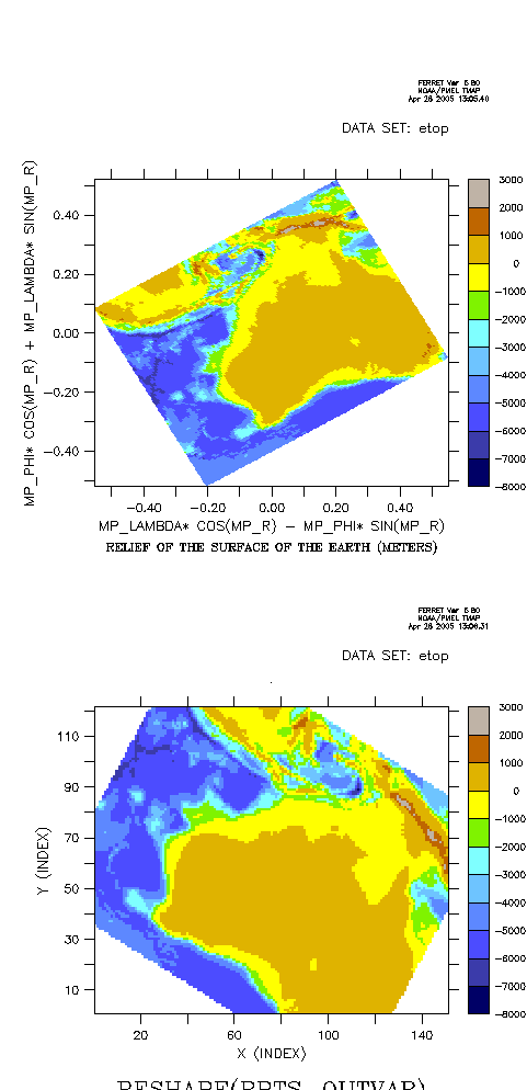
A sample script, using a subset of the ETOPO data so we can see the
rotation easily.
yes? use etopo20
yes? save/clobber/file=esubset.nc rose[x=100:150,y=-40:0]
yes? can data/all
! Do the rotated map projection
yes? use esubset
yes? set grid rose
yes? go mp_rotate 30
yes? shade/pal=land_sea rose, x_page, y_page
! The rotation variables are defined in radians.
! Define axes in radians, and transfer ROSE onto them
yes? def axis/x xrad=mp_lambda
yes? def axis/y yrad=mp_phi
yes? let roserad = rose[gx=xrad@asn,gy=yrad@asn]
! Set up the points to sample ROSERAD at;
! all the locations on the rotated grid, as a
! simple lists of x, y, and function.
yes? let xx = xsequence(x_page)
yes? let yy = xsequence(y_page)
yes? let rpts = samplexy(roserad, xx, yy)
! This is the output grid, in rotated space. (Give
! the axes units of INDEX to emphasize this is in
! index space).
yes? let nx = `rose,return=isize`
yes? let ny = `rose,return=jsize`
yes? def axis/x=1:`nx`:1/units=index xrot
yes? def axis/y=1:`ny`:1/units=index yrot
! The reshape function puts our sampled points on
! the output grid.
yes? let outvar = x[gx=xrot] + y[gy=yrot]
yes? shade/pal=land_sea reshape(rpts, outvar)
[Thread Prev][Thread Next][Index]
Dept of Commerce /
NOAA /
OAR /
PMEL /
TMAP
Contact Us | Privacy Policy | Disclaimer | Accessibility Statement