![]()


|
|
|
DRAFT Cruise Instructions FOCI CCGS SIR WILFRID LAURIER, Cruise LA-02-01 October 6 - October 17, 2002 Chief Scientist - Carol DeWitt
1.0 DRAFT CRUISE INSTRUCTIONS
1.1 Cruise Title – Fisheries-Oceanography Coordinated Investigations (FOCI).
1.2 Cruise Numbers – LA-02-01
1.3 Cruise Dates
1.3.1 Departure – Depart Nome, Alaska, on Sunday, October 6, 2002.
1.3.2 Touch-and-Go – Dutch Harbor, Alaska, on Thursday, October 10, 2002, to load remaining mooring equipment.
1.3.3 Arrival – Arrive Dutch Harbor, Alaska, on Thursday, October 17, 2002.
2.0 CRUISE OVERVIEW – Fisheries-Oceanography Coordinated Investigations (FOCI) is an effort by National Oceanic and Atmospheric Administration (NOAA) and associated academic scientists. At present, FOCI consists of a Shelikof Strait (western Gulf of Alaska) Walleye Pollock project, and a NOAA Coastal Ocean Program (COP) project: Southeast Bering Sea Carrying Capacity (SEBSCC). FOCI also supports associated projects, such as the Steller Sea Lion (SSL) Research Initiative, Arctic Research Initiative (ARI), United States Global Ocean-Ecosystem Coupling (U.S. GLOBEC), and National Science Foundation (NSF) Inner Front Study, that address scientific issues related to FOCI’s mission. FOCI’s goal is to understand the effects of abiotic and biotic variability on ecosystems of the North Pacific Ocean and Bering Sea in order to discern the physical and biological processes that determine recruitment variability of commercially valuable finfish and shellfish stocks in Alaskan waters.
2.1 Cruise Objectives
· Recover and deploy moorings at the FOCI study areas Site 2 and Site 4, · Recover and deploy moorings for the SSL project in the Aleutian Islands study areas, · Conduct Conductivity, Temperature, and Depth (CTD) profile casts at all mooring sites, and possibly other stations, and · Deploy satellite-tracked drifters at designated sites.
2.2 Operating Area – Bering Sea and North Pacific Ocean.
2.3 Participating Organizations
NOAA – Pacific Marine Environmental Laboratory (PMEL) 7600 Sand Point Way N.E., Seattle, Washington 98115-6439
University of Alaska, Fairbanks (UAF) Institute of Marine Science, Fairbanks, Alaska 99775-7220
2.4 Personnel
2.4.1 Chief Scientists
2.4.2 Participating Scientists
2.5 Administrative
2.5.1 Ship Operations
Institute of Ocean Sciences Department of Fisheries and Oceans 9860 West Saanich Road Sidney, British Columbia, Canada V8L 4B2
Dr. Eddy Carmack, Research Scientist Telephone: (250) 363-6585 E-Mail: CarmackE@pac.dfo-mpo.gc.ca
Bon van Hardenberg, Chief Scientist Telephone: (250) 363-6373 E-Mail: vanHardenbergB@pac.dfo-mpo.gc.ca
2.5.2 Scientific Operations
Dr. Phyllis J. Stabeno, PMEL Telephone: (206) 526-6453 E-mail: Phyllis.Stabeno@noaa.gov
3.0 OPERATIONS
3.1 Responsibilities
3.1.1 Commanding Officer – The ship’s Commanding Officer shall be in sole command of the vessel and shall be responsible for the welfare of all personnel on board. The Commanding Officer shall be the final authority in matters relating to the safety, proper navigation, stability, and sailing condition of the vessel and shall execute each voyage with the utmost dispatch.
The Commanding Officer shall inform the Chief Scientist as soon as possible of any changes in the program necessitated by events. In the case of emergency, nothing in these instructions shall be construed as preventing the Commanding Officer from taking the most effective action which, in the Commanding Officer’s judgment, will rectify the situation causing the emergency, and; thereby, safeguard life, property, and the ship.
The Commanding Officer will have the authority to abort operations temporarily on the basis of clear and present danger to life and property at sea, and will inform the Chief Scientist as soon as safe conditions permit. Full details of the action taken, rationale, and recommendations will be provided at the earliest opportunity. Under normal operating conditions, the Commanding Officer shall not take any mission-aborting action without consultation with the Chief Scientist.
3.1.2 Chief Scientist – The Chief Scientist is responsible for executing the technical portion of the scientific mission specified by these instructions. Responsibilities also include: 1. Comportment of visiting scientists and technicians, 2. Disposition of data, feedback on data quality, and archiving of data and specimens collected, 3. Administration and physical handling of all scientific party hazardous materials, 4. Assignment of berthing for the scientific party, 5. Cleanliness of all berthing, laboratory, and storage spaces used by the scientific party, 6. Delivery of medical and emergency contact forms for the scientific party, 7. With the Commanding Officer, safe, efficient, and economical use of shipboard resources to support the embarked mission.
The Chief Scientist has the authority to revise or alter the technical portion of the instructions as work progresses provided that, after consultation with the Commanding Officer, it is ascertained that the proposed changes will not:
1. Jeopardize the safety of personnel or the ship, 2. Exceed the overall time allotted for the project, 3. Result in undue additional expenses, or 4. Alter the general intent of these project instructions.
3.1.3 Scheduling – Scheduling of individual activities will depend upon weather conditions and progress of scientific work. Therefore, firm advance scheduling of events will not be possible, and a continual dialogue between scientific and ship's personnel will be important. To insure fulfillment of all scientific objectives, the ship is asked to steam at maximum cruising speed whenever time in transit, or between stations, is greater than one hour.
3.2 Data To Be Collected – The Chief Scientist is responsible for the disposition, feedback on data quality, and archiving of data and specimens collected on board the ship for the primary project. The Chief Scientist will be considered the representative of the Director of PMEL for purpose of data disposition. A single copy of all data gathered by the vessel shall be delivered to the Chief Scientist upon request for forwarding to Laboratory Director, who in turn will be responsible for distribution of data to other investigators desiring copies.
3.2.1 Data Logging – It is requested, if the ship has a computer system that operates throughout the cruise acquiring and logging data from navigation, meteorological, and flow-through oceanographic sensors, that we receive a copy of the data at the end of the cruise.
3.2.2 Navigation – Observations and reliable fixes shall be plotted and identified by date/time group, or equivalent by ship’s officers. Fixes shall be evaluated for course and/or speed made good. Global Positioning Satellite (GPS), radar range and bearing, and/or visual fixes shall provide primary navigational control.
3.3 Cruise Plan – A standard physical oceanographic crew will be utilized that consists of a winch operator, a scientist and a Survey Technician, or equivalent, on deck. A nutrient/chlorophyll scientist will participate as necessary. Mooring scientists and deck department personnel will be required for all mooring operations. Operations will occur 24 hours per day.
Operations during Cruise LA-02-01 will consist of mooring recoveries, mooring deployments, Conductivity, Temperature, and Depth (CTD) profiler casts, California Cooperative Oceanic Fisheries Investigation (CalCOFI) Vertical Egg Tow (CalVET) net tows, water sample collections, and drifter deployments. CTD casts optimally are performed before each mooring recovery and after each mooring deployment. For expediency, a single cast may be made in lieu of two at the discretion of the Chief Scientist. The Chief Scientist may order additional CTD casts. Water samples shall be taken as possible to insure accuracy of sensors and to measure nutrient levels.
The Chief Scientist may adjust the schedule to provide daylight for recovery operations. In the event that conditions prohibit mooring deployments/recoveries, operations will focus on CTD lines to be selected by the Chief Scientist.
3.4 Mooring Operations – An inventory listing of scientific equipment is provided in Section 7.1 Equipment Inventory.
· Site 4 Recover one (1) mooring; deploy one (1) mooring, · Site 2 Recover four (4) moorings; deploy three (3) moorings, · Alaska Stream Deploy four (4) moorings, · Akutan Pass Recover two (2) moorings, · Samaiga Pass Deploy five (5) moorings, · Amukta Pass Recover four (4) and deploy four (4) moorings, · Seguam Pass Recover three (3) and deploy three (3) moorings, and · Site 6 Deploy one (1) mooring.
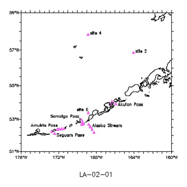
3.5 Station Locations – A list of the proposed order of stations and operations is provided in Sections 7.2 Cruise LA-02-01 Chartlet and 7.4 Station Locations and Itinerary.
3.6 Station Operations – The following are operations to be conducted on this cruise. Details and times of operations are appended to these instructions. The Chief Scientist will provide to ship's personnel before the start of the cruise, any modifications to the operations, locations, or mooring diagrams contained in these instructions. The expected order of operations is as follows:
· Mooring calibration CTD casts will be completed while on each mooring recovery and deployment site. · At Site 4, one (1) subsurface mooring will be recovered and one (1) subsurface mooring will be deployed. CTD casts will be conducted at the mooring location. · As time permits, four (4) CTD casts and CALVet net tows will be conducted at four (4) locations around Site 2. · At Site 2, one (1) surface and three (3) subsurface moorings will be recovered and three (3) subsurface moorings will be deployed. CTD casts will be conducted at the mooring location. · Upon completion of Site 2 operations, the ship will proceed to Dutch Harbor, Alaska, for a touch and go to load equipment needed for the remainder of the cruise. · At the Alaska Stream site, four (4) deep subsurface moorings will be deployed. CTD casts will be conducted at the mooring locations. Four (4) satellite-tracked drifters will be deployed along the Alaska Stream mooring line during CTD operations. · At Samaiga Pass, five (5) subsurface moorings will be deployed. CTD casts will be conducted at the mooring locations. · At Amukta Pass, four (4) moorings will be recovered and four (4) moorings will be deployed. CTD casts will be conducted at the mooring locations. · After Amukta Pass operations, Canadian scientists will service a mooring for several hours. · At Seguam Pass, three (3) moorings will be recovered and three (3) moorings will be deployed. CTD casts will be conducted at the mooring locations. · At Site 6, one (1) subsurface mooring will be deployed, and a CTD will be conducted at the mooring location. · At Akutan Pass, two (2) subsurface moorings will be recovered.
3.6.1 CTD/Water Sample Operations – A Sea-Bird Electronics’ SBE 25 SEALOGGER Conductivity, Temperature, and Depth (CTD) profiler will be the primary system. The primary system will be provided and maintained by the ship. Scientists will keep the CTD Cast Information/Rosette Log. Pressure, salinity, temperature, fluorescence, and light levels will be recorded on the CTD Cast Information/Rosette Log for all water bottle samples.
3.6.1.1 CTD Calibration – Salinity samples will be taken on every cast, or as specified by the Chief Scientist. No reversing thermometers will be required.
3.6.2 CalVET Net Tows - California Cooperative Oceanic Fisheries Investigation (CalCOFI) Vertical Egg Tow (CalVET) net tows to collect microzooplankton and free-floating copepod eggs will be conducted, sometimes in conjunction with Conductivity, Temperature, and Depth (CTD) profiler and Niskin water bottle casts. Scientists will require the assistance of the ship’s complement for deploying and recovering the CalVET net. The CalVET is clamped to the wire on winch and a “book clamp” is placed on the wire where the cod-ends hang to keep the net taut. When used with a Sea-Bird Electronic SBE 19 SEACAT, the SEACAT is placed above the cod-ends. The ship is requested to maintain a constant vertical wire angle during the entire cast. After descent to the desired depth, usually 60 meters, the net will then be retrieved at a rate of 60 meters per minute. The samples will be washed into the cod-ends, and then preserved in 32-ounce jars with Formalin for later analysis.
3.6.3 ARGOS Satellite Tracked Drifter Buoy Deployments – Two to three working days before deployment, the Chief Scientist, or designee, will secure the drifter on the back deck. The drifter buoy is then turned on, usually by removing the magnet, and an e-mail message will be sent by the Chief Scientist, or designee, to Dr. Phyllis Stabeno at Phyllis.Stabeno@noaa.gov, stating the serial number that is stamped on the drifter and the time that it was turned on. This lead-time is necessary to ensure that telemetry from the buoy is being received and transmitted by the Advanced Research and Global Observation Satellite (ARGOS). The method of deployment of the drifter is dependent upon the particular make of drifter and is to be directed by the Chief Scientist, or designee.
3.7 Small Boat Operations – The small boat may be used to tag surface moorings during recovery operations. This boat may also be needed for servicing a mooring by Canadian scientists.
4.0 FACILITIES
4.1 Equipment and Capabilities Provided by Ship
· Capstan or winch system for recovery and deployment of moorings, · Oceanographic winch and CTD, · EK-500 or suitable water depth indication to 1500 meters, · Wire speed indicators for CTD winch, · Meteorological observations each hour and for each operation, · Laboratory space, sink, lab tables and storage space, · Adequate deck lighting for night-time operations, · Navigational equipment including GPS and radar, and · Safety harnesses for working on quarter deck and fantail.
4.2 Equipment and Capabilities Provided by Scientists
· Subsurface moorings, and · Miscellaneous scientific sampling and processing equipment.
5.0 HAZARDOUS MATERIALS
5.1 Inventory List – See Section 7.3 HAZMAT Inventory.
5.2 Material Data Safety Sheets (MSDS) – Submitted separately as electronic attachments.
6.0 COMMUNICATIONS – For scientific projects, the Chief Scientist, or their designated representative, may have access to the ship's communications systems on a cost reimbursable basis.
6.1 Receiving Scientific Status Reports – The Chief Scientist may anticipate the need for daily reports on the position of satellite drifters in the study area and on the status of biophysical mooring(s). These will be sent either by facsimile from PMEL over INMARSAT or over the Internet via email from PMEL.
6.2 Use of Radio Transceivers – Because it is sometimes necessary for the scientific staff to communicate with other research vessels, commercial vessels, and shore based NOAA facilities, the Chief Scientist or designee may request the use of radio transceivers aboard the vessel.
6.3 Radio Interference – Some scientific equipment is sensitive to radio frequency interference. When interference occurs, it may be necessary to adjust operations and communications schedules if efforts to electronically isolate the equipment are unsuccessful.
6.4 Important Telephone, Facsimile Numbers, and E-mail Addresses
6.4.1 Pacific Marine Environmental Laboratory (PMEL)
6.4.1.1 FOCI – Ocean Environmental Research Division (OERD2)
· (206) 526-4700 (voice) · (206) 526-6485 (fax)
6.4.1.2 Administration
· (206) 526-6810 (voice) · (206) 526-6815 (fax)
6.4.1.3 E-Mail – FirstName.LastName@noaa.gov
6.4.2 CCGS SIR WILFRID LAURIER – To contact the ship while at sea, telephone the Regional Operations Center at (250) 413-2800.
6.4.2.1 Mail
CCGS SIR WILFRID LAURIER Attn: (person’s name) C/O Victoria Base 25 Huron Street Victoria, British Columbia, Canada V8V 4V9
6.4.2.2 E-mail – laurier@pac.dfo-mpo.gc.ca
6.4.3 Institute of Ocean Sciences:
· Dr. Eddy Carmack, Research Scientist Telephone: (250) 363-6585 E-Mail: CarmackE@pac.dfo-mpo.gc.ca
· Bon van Hardenberg, Chief Scientist Telephone: (250) 363-6373 E-Mail: vanHardenbergB@pac.dfo-mpo.gc.ca
7.0 APPENDICES
7.1 Equipment Inventory – Lists of equipment will be provided in the final cruise plan.
7.4 Station Locations and Itinerary
| |||||||||||||||||||||||||||||||||||||||||||||||||||||||||||||||||||||||||||||||||||||||||||||||||||||||||||||||||||||||||||||||||||||||||||||||||||||||||||||||||||||||||||||||||||||||||||||||||||||||||||||||||||||||||||||||||||||||||||||||||||||||||||||||||||||||||||||||||||||||||||||||||||||||||||||||||||||||||||||||||||||||||||||||||||||||||||||||||||||||||||||||||||||||||||||||||||||||||||||||||||||||||||||||||||||||||||||||||||||||||||||||||||||||||||||||||||||||||||||||||||||||||||||||||||||||||||||||||||||||||||||||||||||||||||||||||||||||||||||||||||||||||||||||||||||||||||||||||||||||||||||||||||||||||||||||||||||||||||||||||||||||||||||||||||||||||||||||||||||||||||||||||||||||||||||||||||||||||||||||||||||||||||||||||||||||||||||||||||||||||||||||||||||||||||||||||||||||||||||||||||||||||||||||||||||||||||||||||||||||||||||||||||||||||||||||||||||||||||||||||||||||||||||||||||||||||||||||||||||||||||||||||||||||||||||||||||||||||||||||||||||||||||||||||||||||||||||||||||||||
|