![]()
![]()
![]()
|
|
|
24 July 2000
NOAA Ship Ronald H. Brown
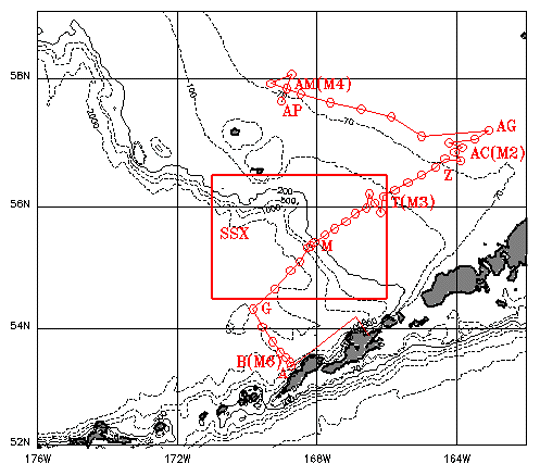
Dates: 26 Aug 2000 depart Dutch Harbor, AKChief Scientist: Edward D. Cokelet, Ph D1.0 Cruise Overview 1.1 Program Description: The Fisheries-Oceanography Coordinated Investigations (FOCI) are an effort by NOAA and academic scientists to understand the physical and biological processes that determine recruitment variability of commercially valuable fin-fish and shellfish stocks in Alaskan waters. FOCI consists of several projects including the present ones funded by the Southeast Bering Sea Carrying Capacity (SEBSCC) and the North Pacific Marine Research (NPMR) Programs.1.2 Cruise Objectives: The SEBSCC program element objective is to monitor the water properties and circulation along an oft-repeated oceanographic section in the Bering Sea. We will reoccupy the standard SEBSCC Monitoring Line of CTD casts in the basin, across the continental shelf past mooring sites M3 and M2, and along the 70-m isobath to mooring site M4 (Fig. 1).1.2.1 NPMR Purpose and Objectives: The purpose of the NPMR project is to understand the influence of mesoscale eddies on continental slope-shelf exchange in the Southeastern Bering Sea. The objectives are to These instructions in conjunction with the "FOCI Standard Operating Instructions for NOAA Ship Ronald H. Brown, 2000" provide complete information for this cruise. The Chief Scientist is authorized to alter the scientific portion of this cruise plan with the concurrence of the Commanding Officer, provided that the proposed changes will not (1) Jeopardize the safety of personnel or the ship,1.4 Operating Area: Southeastern Bering Sea (see Fig. 1).1.5 Participating Organizations NOAA/Pacific Marine Environmental Laboratory (PMEL)1.6 Personnel
1. 7.1 Ship Operations: CDR Jon Rix, Chief1.7.2 Scientific Operations: LCDR Dave Mattens2.0 Operations 2.1 Data to be collected: Measurements will be collected with shipboard sensors including the ADCP and Sea Beam, a CTD profiler with water bottles, and user-supplied mast-mounted radiometers, tethered spectral radiometer buoy (TSRB) and spectral radiometer profiler. A few satellite-tracked drifting buoys will also be launched.2.1.1 SCS: SCS will be configured to record the following: The ADCP will be configured according to the Chief Scientists specifications. It should receive position input from a P-code GPS receiver with DGPS input as a backup and heading from the Ring-Laser Gyro and auxiliary heading from the Seapath 200. Data will be stored on 3.5" floppy disks or 100 MB Zip disks.2.2.3 Sea Beam: Sea Beam data may be collected on site-specific surveys as required and stored for transport back to PMEL.2.2.4 CTD CTD cast data will be collected on the ships Sea Bird 911+ system. There will be approximately 100 CTD casts. 12 10-liter water samples will be taken on most casts.2.2.5 AutoSal: AutoSal runs will be done to compare salinities with CTD values. Usually 2 samples will be taken per cast - one at depth and one in the surface mixed layer. This could be relaxed to one sample per cast - alternating between deep and mixed-layer samples.2.2.6 Satellite Observations: AVHRR and SeaWiFS satellite observations of SST and ocean color will be downloaded using TeraScan and full-resolution, geo-referenced images made available in a timely manner to facilitate cruise planning. In clear weather these should prove invaluable for locating nutrient-rich slope water that moves onto the shelf and promotes phytoplankton blooms.2.2.7 Marine Operations Abstract: The ship will maintain a Marine Operations Abstract (MOA) on paper giving the date, time and location of significant events such as CTD casts, buoy deployments, etc.2.2 Staging plan: Some gear will be loaded in Seattle during the 4-9 Aug 2000 in-port. The remaining gear will be shipped to Dutch Harbor and loaded on 25 Aug 2000. Access to the ship as soon as possible after its arrival in Dutch Harbor is needed because the chemical analysis equipment requires extensive set-up. The scientific party has secured use of an NMFS van to move gear from the airport and/or the docks to the ship in Dutch Harbor.2.3 Cruise plan: The cruise has two primary goals: reoccupy the SEBSCC Monitoring Line and study slope-shelf interaction. Work will be divided into 4 stages as follows (see Itinerary in Table 1):
The purpose of the NPMR observations is to locate one or more eddies interacting with the Southeastern Bering Sea shelf break and sample the evolving flux of nutrient-rich slope water onto the continental shelf and associated primary production changes. Before and during the cruise, eddies will be located in three ways:
Nutrient samples will be taken and analyzed aboard ship. Optical properties will be measured using spectral profiling and floating radiometers. Biological, bio-optical and physiological measurements, such as chlorophyll-a concentration, particulate absorption, and in vivo fluorescence, will be collected.2.3.1.2 Sampling onshore flow: The speed and direction of the drifters within the onshore flow will not tell us its width, but previous work indicates that the breadth of an episodic onshore flow event is approximately 10-20 km. Estimates of jet size from remote sensing and onboard analysis of data will allow for real-time modification of the sampling scheme to accommodate the actual size of the jet encountered, within the available ship time. The ship will follow a zig zag pattern, crossing the onshelf flow approximately 5 times until the 100 m isobath is reached. Stations will be occupied every 5 to 10 km along any one diagonal.2.3.1.3 Alternative NPMR Plan: Drifters deployed on an earlier cruise along with altimeter data will be used to identify possible sites of episodic onshelf flow. There is, however, the chance that no onshelf flow events will be identified. If an episodic event is not located using either method, then the presence and effects of the relatively persistent onshelf flow, as evident in drifter trajectories and hydrographic surveys from past years, at either Bering Canyon or Pribilof Canyon will be examined. The sampling schedule will be as described, proceeding from the head of the canyon towards the shelf.2.4 Waypoints: SEBSCC Monitoring Line station locations are listed in Table 1. If possible, the Chief Scientist will e-mail the approximate location of the NPMR study area to the ship a few days in advance of the cruise, once we have determined it from satellite-tracked drifting buoy trajectories and satellite images. Owing to the dynamic nature of the interaction of Bering Slope Current eddies with the shelf break, it will not be possible to provide sampling points until the day of departure. The sampling area will evolve with the eddy interaction.2.5 Station operations: CTD operations will proceed 24 hours per day in the study area for ~160 casts. We request that the ship provide 2 Survey Technicians to support these casts and ~320 AutoSal salinity determinations. The CTD will be deployed with 12 10-liter bottles on its rosette, a flash fluorometer, a beam transmissometer and an altimeter. Care must be taken at the SEBSCC mooring sites (M6, M3, M2, M4 of Table 2) to avoid fouling the CTD on the mooring gear.2.5.1 Standard SEBSCC station: A standard SEBSCC station will consist of a CTD profile to the shallower of 1500 m or ~10 m above the sea bed with nutrient samples at selected depths. Where not depth limited, the CTD package will include a light meter, fluorometer, beam transmissometer and altimeter.2.5.2 Standard NPMR station: A standard NPMR station will consist of the following:
Several underway measurements are required. The Thermosalinograph, flow-through fluorometer, and ADCP will be used continuously. These and other SCS data should be logged throughout the cruise.2.6.1 Radiometers: Dalhousie scientists wish to mount 2 radiometers on the ship - 10 and 25 cm in diameter - probably on the ships mast. Solar shadowing needs to be minimized, but they need not be mounted at the highest point on the ship. Often the forward mast is an appropriate location. These should be logged by SCS.2.6.2 Sea Beam: Bering Sea eddies may interact with the continental shelf in submarine canyons and at discontinuities in the shelf break. Since Bering Sea bathymetry is poorly known, we may wish to map the bottom using Sea Beam in areas of eddy impingement.2.7 Applicable restrictions: None.2.8 Small boat operations: None planned.2.9 De-staging plan: Gear will be off-loaded in Dutch Harbor on 14 Sep 2000 and transported via NMFS van to the airport.3.0 Facilities 3.1 Equipment and capabilities provided by ship:
PMEL:
4.1 Data responsibilities: The Chief Scientist will receive all original data gathered by the ship for the primary project, and this data transfer will be documented on NOAA Form 61-29 "Letter Transmitting Data". The Chief Scientist in turn will furnish the ship a complete inventory listing all data gathered by the scientific party detailing types and quantities of data. The Chief Scientist will be responsible for the disposition, feedback on data quality, and archiving of data and specimens collected on board the ship for the primary project. The Chief Scientist will also be responsible for the dissemination of copies of these data to participants in the cruise, to any other requesters, and to notify NODC of measurements and samples taken at sea via a Cruise Summary Report (IOC ROSCOP, Third Edition). The ship may assist in copying data and reports insofar as facilities allow. Metadata describing data collected during FOCI, SEBSCC, and NPMR cruises must be submitted to the Bering Sea Ecosystem Biophysical Metadatabase within one month of completion of the cruise. On-line guidance and submission forms are available through the World Wide Web at http://www.pmel.noaa.gov/np/mdb/index.html . Alternatively, forms may be requested from the FOCI Coordinator.4.1.1 Discrete Sample Data Base: The Chief Scientist will ensure that all stations, deployments, etc. are entered into the FOCI Discrete Sample DataBase.4.1.2 Piggyback projects: Individuals in charge of supplementary ("piggyback") projects conducted during the cruise have the same responsibilities for their project's data as the Chief Scientist has for primary project data. All requests for data should be made through the Chief Scientist.4.1.3 Data transfer: The Commanding Officer is responsible for all data collected for fleet ancillary projects until those data have been transferred to the project's principal investigators or their designees. Data transfers will be documented on NOAA Form 61-29. Copies of fleet ancillary project data will be provided to the Chief Scientist when requested. Reporting and sending copies of fleet ancillary project data to NESDIS (ROSCOP) is the responsibility of the program office sponsoring those projects.4.2 Pre- and post-cruise meetings: All scientific personnel will meet with ships representatives in a pre-cruise meeting the day of departure to discuss scientific objectives, operations, safety and Standing Orders. A post-cruise meeting will be scheduled between the Chief Scientist and Commanding Officer for a convenient time at the end of the cruise. Project accomplishments will be reviewed, as will general aspects of ship's performance and any administrative issues.4.3 Ship operation evaluation report: Reporting requirements for the Shipboard Operations Evaluation Form, to be completed and submitted by the Chief Scientist to the Office of Marine and Aviation Operations (OMAO) within 30 days of cruise completion, will also be reviewed.5.0 Additional Projects Any additional work will be subordinate to the primary project and will be accomplished only with the concurrence of the Commanding Officer and the Chief Scientist(s).5.1 Supplementary ("Piggyback") projects: 5.1.1 Underway Measurements in support of Global Carbon Cycle Research (GCC) 5.1.1.1 Request: As part of the ongoing research to quantify the CO2 uptake by the world's oceans we have installed underway systems on the BROWN. On many cruises we request bunk space for one scientist of our laboratories to maintain the many systems outlined below. If we cannot send a dedicated person we try to have a scientist of the specific scientific party look after the Underway pCO2 system (described in section A4 below). On some cruises we are unsuccessful in attracting a volunteer and would like to use the services of the survey technician for the Underway pCO2 system only . After initial start-up, which requires about one hour of monitoring, the system needs checking twice a day requiring a total of about 20-minutes. We would also request weekly data downloads and transmission such that we can perform on shore near-real-time quality control to assess if the instrument is operating satisfactorily. All costs of the email transmissions and survey technician overtime would be covered by AOML. The chief survey technician, J. Shannahoff, has operated the instrument before with good results. In the event of system malfunction that cannot be easily repaired, we will ask Mr. Shannahoff to shut the system down. The shoreside leader of the effort, Mr. Robert Castle has interacted closely with J. Shannahoff and feels that this arrangement would work well.5.1.1.2 Introduction: The underway sensors on RHB will be used in support of the objectives of the Global Carbon Cycle Research (GCC) to quantify the uptake of carbon by the world's ocean and to understand the bio-geochemical mechanisms responsible for variations of partial pressure of CO2 in surface water (pCO2). This work is a collaborative effort between the CO2 groups at AOML and PMEL. Current estimates of anthropogenic CO2 uptake by the oceans range from 1 to 2.8 Gigatons per year. The CO2 fluxes between air and water are poorly constrained because of lack of seasonal and geographic coverage of delta pCO2 (the air-water disequilibrium) values and incomplete understanding of factors controlling the air-sea exchange of carbon dioxide. Seasonal and temporal coverage can be increased dramatically by deploying pCO2 analyzers on ships. The effort on the RHB is expanded beyond the historical scope of the underway programs by incorporating additional sensors to improve our understanding of the factors controlling pCO2 levels.5.1.1.4 Sensor Suite and Maintenance: A. Underway pCO2 system5.1.1.5 Summary - Ship infrastructure support: 1. Continuous seawater supply: 20 lpm minimum, 40 lpm maximum for instruments, and 75 lpm throughput to assure short residence time of water in line and minimal heating.5.2 NOAA Fleet ancillary projects: Ancillary tasks will be accomplished in accordance with the NOAA Fleet Standing Ancillary Instructions.6.0 Hazardous Materials 6.1 Policy/Compliance: Ronald H. Brown will operate in full compliance with all NOAA hazardous materials (HAZMAT) requirements. All hazardous materials and substances needed to carry out the objectives of the embarked science mission, including ancillary tasks, are the direct responsibility of the embarked designated Chief Scientist, whether or not that Chief Scientist is using them directly. The ship's Environmental Compliance Officer will work with the Chief Scientist to ensure that this management policy is properly executed.6.1.1 Material Safety Data Sheets: All hazardous materials require a Material Safety Data Sheet (MSDS). Copies of all MSDSs shall be forwarded to the ship at least two weeks prior to sailing. The Chief Scientist shall have copies of each MSDS available when the hazardous materials are loaded aboard. HAZMAT for which the MSDS is not provided will not be loaded aboard.6.1.2 Provision of inventory: The Chief Scientist will provide the Commanding Officer with an inventory indicating the amount of each hazardous material brought onboard, and for which the Chief Scientist is responsible. This inventory shall be updated at departure from the ship, accounting for the amount of material being removed, as well as the amount consumed in science operations and the amount being removed in the form of waste.6.1.3 HAZMAT locker: The ship's dedicated HAZMAT Locker contains two 45-gallon capacity flame cabinets and one 22-gallon capacity flame cabinet, plus some available storage on deck. All HAZMAT, except small amounts for ready use, must be stored in the HAZMAT Locker. If science party requirements exceed ship's storage capacity, excess HAZMAT must be stored in dedicated lockers meeting OSHA/NFPA standards to be provided by the science party.6.1.4 Emergency response preparation: The scientific party, under supervision of the Chief Scientist, shall be prepared to respond fully to emergencies involving spills of any mission HAZMAT. This includes providing properly trained personnel for response, as well as the necessary neutralizing chemicals and clean-up materials. Ship's personnel are not first responders and will act in a support role in the event of a spill. The Chief Scientist shall provide a list of science party members that are properly trained to respond in the event of HAZMAT spills.6.1.5 Responsibility: The Chief Scientist is directly responsible for the handling, both administrative and physical, of all scientific party hazardous wastes. No liquid wastes shall be introduced into the ship's drainage system. No solid waste material shall be placed in the ship's garbage.6.1.6 Inheritance: The embarking Chief Scientist will work with the departing Chief Scientist and the ship's Environmental Compliance Officer to ensure proper tracking of inherited hazardous materials.6.2 Inventory: PMEL: None6.3 Material Safety Data Sheets (MSDS) UAF: MSDS Forms are packed with chemicals and will transferred from the Miller Freeman when the chemicals are unloaded. A spare copy of the MSDS forms will accompany the PI/student.7.0 Radioactive Isotopes 7.1 Radioactive isotope policy: Ronald H. Brown has no specially designed lab space for working with isotopes. We will therefore require that all radioisotope work be done in a dedicated van with its own storage area and separate waste discharge. This policy is consistent with that of the UNOLS fleet. All of the waste should remain segregated from the ship's waste and be packed out by the investigator.7.1.1 Protective clothing: Each scientist working with these materials will be required to wear a lab coat and disposable booties to reduce the likelihood of tracking the substance out of the van and into the ship.7.1.2 Wipe tests: It will be the responsibility of the investigator to conduct pre-cruise (for background) and post-cruise wipe tests (regardless of whether a spill occurred or not). Wipe tests should also be conducted in the event of a spill, as well as periodically while underway.7.1.3 Methodology: A detailed procedural methodology describing the use of these materials should be provided to the Environmental Compliance Officer(ECO) for review at least one month prior to bringing them aboard. A spill contingency plan should also be provided at the same time. Please note that ship's personnel are not first responders in the event of a spill.7.1.4 Log: A log detailing the type and amount of materials brought aboard and removed from of the ship shall be maintained, along with a record of any spills that occurred.7.1.5 Licenses: All radioisotope work will be conducted by NRC or State licensed investigators only, and copies of these licenses shall be provided to the ECO at least one month prior to bringing any materials on board.7.2 Inventory: PMEL: None7.3 License and License Holder: Not applicable.8.0 Miscellaneous 8.1 Scientific Berthing: The Chief Scientist is responsible for assigning berthing for the scientific party within the spaces approved as dedicated scientific berthing. The Ops Officer will send stateroom diagrams to the Chief Scientist showing authorized berthing spaces. The Chief Scientist is responsible for returning the scientific berthing spaces in the condition in which they were received; for stripping bedding and for linen return; and for the return of any room keys which were issued.8.1.1 Cleanliness of assigned spaces: The Chief Scientist is responsible for the cleanliness of the berthing and laboratory spaces and storage areas used by the science party, both during the cruise and at its conclusion prior to departing the ship.8.1.2 Implied consent: In accordance with NC Instruction 5255.0, Controlled Substances Aboard NOAA Vessels, dated 06 August 1985, all persons boarding NOAA vessels give implied consent to conform with all safety and security policies and regulations which are administered by the Commanding Officer. All spaces and equipment on the vessel are subject to inspection or search at any time.8.2 Medical Forms: The NOAA Health Services Questionnaire must be completed in advance by each participating scientist. It will be sent out by the Chief Scientist and should be returned to him in a separate, sealed envelope marked with the participants name, cruise number and cruise dates. It should reach the ship no later than 4 weeks prior to the cruise to allow time to medically clear the individual, to request more information if needed, and to prepare for special circumstances. All personnel must bring with them prescription and routine, over-the-counter medication (e.g. an aspirin a day). Supplies on board are limited, and chances to restock are few.8.2.1 Emergency Contacts: Prior to departure, the Chief Scientist must provide a listing of emergency contacts to the Executive Officer for all members of the scientific party, with the following information: scientists name, emergency contacts name, address, relationship to scientist, telephone number and e-mail address (if available).8.3 Shipboard Safety: Wearing open-toed footwear (such as sandals) outside of private berthing areas is unsafe and is not permitted. Steel-toed shoes are required to participate in any work dealing with suspended loads, including CTD deployment and recovery, on outside weather decks. All members of the scientific party are expected to be aware of these regulations and to comply with them.8.4 Communications: The Chief Scientist or designated representative will have access to ship's telecommunications systems on a cost-reimbursable basis. Where possible, it is requested that direct payment (e.g. by credit card) be used as opposed to after-the-fact reimbursement. Specific information on how to contact the Ronald H. Brown and all other fleet vessels can be found at http://www.moc.noaa.gov/phone.htm.8.4.1 E-mail Policy: Standing Order 9.21-1: In recent years the proliferation of electronic mail (e-mail) and the reduction of INMARSAT costs have permitted the sending of nominal amounts of personal e-mail when transmitted with official ship's business. The availability of e-mail services is a valuable quality of life issue aboard ship. Accordingly, a complimentary amount of personal use will be permitted for all personnel aboard.8.4.1.1 Complimentary amount: At the current time the complimentary amount established by the Office of NOAA Corps Operations is set at $1.50 (15 KB of data - 190 lines of uncompressed text excluding headers, addresses, etc.) per person per day. $1.50 per day may be accumulated over a period of no more than one month such that one person will be allowed $45 per month for e-mail transmission costs. There is no provision for payment to a person who does not utilize the complimentary amount.8.4.1.2 Additional cost: It should be understood that the cost of personal e-mail being transmitted from shore to an individual aboard ship will be charged against that individual's complimentary amount. A detailed billing statement will be issued periodically to any individual or Chief Scientist whose costs have exceeded his or his group's monthly entitlement. All costs in excess of an individual's or group's complimentary amount must be reimbursed. When personal use cannot be easily distinguished from official business, the amount of reimbursement will equal the total cost minus the complimentary amount. Each embarked personnel will have an e-mail account/address established in his/her name by the Lead Electronic Technician (LET) at the time of arrival. The general format is:8.4.2 Satellite Communications: Standing Order 9.21-2: INMARSAT-A (voice and fax) and INMARSAT-M (voice) communications are available aboard ship and may be used for personal or business related calls so long as the caller makes arrangements to pay for the calls. Credit card calls are the preferred method of payment. INMARSAT calls can be extremely expensive and the exact cost may not be known until you receive your bill. Brevity is encouraged. See the Lead Electronic Technician (LET) for any questions regarding the use of these phones. If you do not have a credit card and need to make an INMARSAT call, arrangements to pay by personal check may be arranged with the XO.8.4.2.1 Ship Phone Services: Standing Order 9.21-3: Routine incoming non-emergency phone calls are discouraged. Use e-mail communications for this purpose. In an emergency, embarked personnel can be contacted by phone. Phone numbers for the Ronald H. Brown can be found at http://www.moc.noaa.gov/phone.htm#RB.8.4.2.2 INMARSAT-A: For high speed data transmission, including FTP, and high quality voice telephone communications. Costs range from $5-$11 per minute for use of the service, and may be charged to credit card or otherwise reimbursed.8.4.2.3 INMARSAT MINI-M: For voice telephone communications and 2400 baud data transfer. Cost is about $3 per minute to the US and may be charged to credit card, collect or otherwise reimbursed. Mini-M coverage is by spot beam and may not be available in all the areas the ship may be working in.8.4.2.3.1 Messages: Messages can also be left with the Marine Operations Center, Norfolk, Virginia, by calling (757)441-6206. After hours and on weekends and holidays, an answering service will relay a message to the appropriate duty officer.8.4.3 Ship's Mail: Standing Order 9.22: Incoming letters and packages can be sent to embarked members of the ship's operating crew and scientific complement by addressing them to:8.5 Port Agent Services/Billing: Contractual agreements exist between the port agents and the commanding officer for services provided to the NOAA Ship Ronald H. Brown. The costs or required reimbursements for any services arranged through the ship's agents by the scientific program, which are considered to be outside the scope of the agent/ship support agreement, will be the responsibility of that program. Where possible, it is requested that direct payment be arranged between the science party and port agent, as opposed to after-the-fact reimbursement to the ship's accounts.8.6 Wage Marine Dayworker Working Hours and Rest: Chief Scientist shall be cognizant of the reduced capability of the Ronald H. Brown's operating crew to support 24-hour mission activities with a high tempo of deck operations at all hours. Wage marine employees are subject to negotiated work rules contained in the applicable collective bargaining agreement. Dayworkers' hours of duty are a continuous eight-hour period, beginning no earlier than 0600 and ending no later than 1800. It is not permissible to separate such an employee's workday into several short work periods with interspersed non-work periods. Dayworkers called out to work between the hours of 0000 and 0600 are entitled to a rest period of one hour for each such hour worked. Such rest periods begin at 0800 and will result in no dayworkers being available to support science operations until the rest period has been observed. All wage marine employees are supervised and assigned work only by the Commanding Officer or designee. The Chief Scientist and the Commanding Officer shall consult regularly to ensure that the shipboard resources available to support the embarked mission are utilized safely, efficiently and with due economy.9.0 Appendices 9.1 Equipment Inventory PMEL:
9.3 Tables Table 1. Operations chronology for RB00-07, Leg 1.
Table 2. SE Bering Sea Mooring Locations - July 2000.9.4 Hazardous Materials | |||||||||||||||||||||||||||||||||||||||||||||||||||||||||||||||||||||||||||||||||||||||||||||||||||||||||||||||||||||||||||||||||||||||||||||||||||||||||||||||||||||||||||||||||||||||||||||||||||||||||||||||||||||||||||||||||||||||||||||||||||||||||||||||||||||||||||||||||||||||||||||||||||||||||||||||||||||||||||||||||||||||||||||||||||||||||||||||||||||||||||||||||||||||||||||||||||||||||||||||||||||||||||||||||||||||||||||||||||||||||||||||||||||||||||||||||||||||||||||||||||||||||||||||||||||||||||||||||||||||||||||||||||||||||||||||||||||||||||||||||||||||||||||||||||||||||||||||||||||||||||||||||||||||||||||||||||||||||||||||||||||||||||||||||||||||||||||||||||||||||||||||||||||||||||||||||||||||||||||||||||||||||||||||||||||||||||||||||||||||||||||||||||||||||||||||||||||||||||||||||||||||||||||||||||||||||||||||||||||||||||||||||||||||||||||||||||||||||||||||||||||||||||||||||||||||||||||||||||||||||||||||||||||||||||||||||||||||||||||||||||||||||||||||||||||||||||||||||||||||
|
EcoFOCI Project Office |