|
Date: 6 April 2000
Revised (Sec. 1.2): 14 April 2000
FINAL CRUISE INSTRUCTIONS
NOAA Ship MILLER FREEMAN
Cruise No: MF00-06
FOCI No: 5MF00
Applicability:
These instructions, with
FOCI Standard Operating Instructions for NOAA Ship MILLER FREEMAN, 2000,
present complete information for this cruise.
General geographic area:
Southeastern Bering Sea
Shelf
Itinerary:
Date depart/port: 1 May
2000; Dutch Harbor, AK
Date arrive/port: 12 May 2000;
Dutch Harbor, AK
Participating organizations:
NOAA - Alaska Fisheries
Science Center (AFSC)
University of Alaska, Fairbanks
(UAF)
CRUISE DESCRIPTION:
Fisheries-Oceanography
Coordinated Investigations (FOCI) is an effort by NOAA and associated academic
scientists. At present, FOCI consists of a Shelikof Strait (western Gulf
of Alaska) walleye pollock project, and a NOAA Coastal Ocean Program project:
Southeast Bering Sea Carrying Capacity (SEBSCC). FOCI also supports associated
projects, such as the Arctic Research Initiative, U.S. GLOBEC, and NSF
Inner Front Study, that address scientific issues related to FOCI's. FOCI's
goal is to understand the effects of abiotic and biotic variability on
ecosystems of the North Pacific Ocean and Bering Sea in order to discern
the physical and biological processes that determine recruitment variability
of commercially valuable finfish and shellfish stocks in Alaskan waters.
CRUISE OBJECTIVES:
 |
Occupy hydrographic stations along
SEBSCCs monitoring transects taking CTD, water bottle, bongo, and CalVET
samples. |
|
Reoccupy stations at Moorings 2 &
3 to examine rate processes of nutrient dynamics, primary productivity,
and zooplankton growth and development. |
|
Collect plankton samples for stable
isotope determination |
|
Examine larval fish distribution along
the Alaska Peninsula |
1.0. PERSONNEL
1.1. Chief Scientist:
Jeffrey M. Napp,
M, Alaska Fisheries Science Center
(206) 526 4148; Jeff.Napp@NOAA.gov
The Chief Scientist has the authority
to revise or alter the technical portion of the instructions as work progresses
provided that, after consultation with the Commanding Officer, it is ascertained
that the proposed changes will not: (1) jeopardize the safety of personnel
or the ship; (2) exceed the overall time allotted for the project; (3)
result in undue additional expenses; (4) alter the general intent of these
project instructions.
1.2 Participating Scientists:
Christine Baier,
F, AFSC
Bernard Megrey, M,
AFSC
Destry Wion, M , AFSC
Terry Whitledge, M,
Univ. Alaska Fairbanks
Stephanie Moreland, F,
Univ. Alaska Fairbanks
David Walsh, M, Univ.
Alaska Fairbanks
1.3 NOAA Marine Operations
Center, Pacific Contact:
Larry Mordock
NOAA/MOP (MOP1x4)
1801 Fairview Ave. East
Seattle, WA 98102-3767
(206) 553 - 4764
Larry.Mordock@noaa.gov
1.4 Program Contacts:
Dr. Phyllis Stabeno
PMEL
7600 Sand Point Way NE
Seattle, WA 98115
(206) 526-6453 (206) 526-4108
Phyllis.Stabeno@noaa.gov
Dr. Art Kendall
AFSC
7600 Sand Point Way NE
Seattle, WA 98115
2.0. OPERATIONS
A standard oceanographic
watch will be utilized which consists of a winch operator, a scientific
staff of three and a Survey Tech on deck. Operations will be conducted
24 hours a day.
2.1. SUMMARY OF ACTIVITIES:
After departure we will
proceed to the stations surrounding Mooring 2 (Figure 1). CTD casts (nutrients
and chlorophyll) and tows for zooplankton (bongo and CalVET) will be taken
at the first five stations (Table 1). We will then spend approx. 20 hr.
at M2 for rate measurements (CTD, bongo, CalVET, and 0.8 m Ring net) before
steaming north along the 70 m isobath transect, stopping for CTD and bongo
samples at designated stations. After completing stations on that transect,
we will occupy station M4 for 20 hr to do rate measurements. Upon completion
of those measurements we will steam southwest to sample selected stations
between the Pribilof Islands, then dead head to the shelf break stations.
The cross shelf transect will then be sampled, stopping at M3 for 20 hrs
for more rate measurements. The cross shelf transect stations will then
be resumed, concluding at M2 with 20 hrs of rate measurements. If time
permits, we will take water and plankton samples at stations inshore of
Mooring 2 and do a grid of bongo tows for pollock eggs and larvae beginning
north of Unimak Island and working northeast along the Alaska Peninsula
before returning to Dutch Harbor.
2.2 PROCEDURES FOR OPERATIONS:
The following are operations
to be conducted on this cruise. The procedures for these operations are
listed in the FOCI Standard Operating Instructions (SOI). Operations not
addressed in the SOI and changes to standard procedures are addressed below.
CTD/Water samples (SOI 2.2.1)
MARMAP bongo tow (SOI 2.2.2)
Live zooplankton ring net tow
(SOI 2.2.4)
CalCOFI vertical egg tow (SOI
2.2.6)
Methot trawl (SOI 2.2.7)
Chlorophyll samples (SOI 2.2.10)
ADCP (SOI 2.2.13)
Radiometer (SOI 2.2.14)
Scientific Computing System (SCS,
SOI 3.3)
3.0. FACILITIES AND EQUIPMENT
The following systems
and their associated support services are essential to the cruise. Sufficient
consumables, back-up units, and on-site spares and technical support must
be in place to assure that operational interruptions are minimal. All measurement
instruments are expected to have current calibrations, and all pertinent
calibration information shall be included in the data package.
3.1 Equipment and Capabilities
to be Provided by the Ship
Oceanographic winch with
slip rings and 3-conductor cable terminated for CTD,
Wire-angle indicator and readout
for oceanographic winch,
Oceanographic winch for bongo
net (and other nets when used) with slip rings and 3-conductor cable terminated
for the SeaCat,
Sea-Bird 911 plus CTD system to
be used with PMEL stand (primary system)
(The underwater CTD unit should
have mounts compatible with the PMEL CTD stand),
Sea-Bird 911 plus CTD system with
stand (back up system),
(Each CTD system should include
underwater CTD, weights, and pinger and there should be one deck unit and
tape recorder for the two systems),
10-liter sampling bottles for
use with rosette (10 plus 4 spares),
For CTD field corrections -- AUTOSAL
salinometer,
Sea-Bird SBE-19 Seacat system
(backup system),
Meter block for plankton tows,
Wire speed indicators and readout
for DataPlot and quarterdeck, Rowe and Marco winches,
For meteorological observations:
2 anemometers (one R. M. Young system interfaced to the SCS), calibrated
air thermometer (wet-and dry-bulb) and a calibrated barometer and/or barograph,
Freezer space for storage of biological
and chemical samples (blast and storage freezers),
Simrad EQ-50 echo sounder ,
JRC JFV-200R color sounder recorder,
RDI ADCP written to SCS and Iomega
Zip drives,
Use of Pentium PC in DataPlot
for data analysis,
SCS (Shipboard Computer System),
Aft Marco winch with cable for
Methot
Laboratory space with exhaust
hood, sink, lab tables and storage space,
Sea-water hoses and nozzles to
wash nets (quarterdeck and aft deck),
Adequate deck lighting for night-time
operations,
Navigational equipment including
GPS and radar ,
Safety harnesses for working on
quarter deck and fantail,
3.2 Equipment to be Provided by
the Project
Sea-Bird SBE-19 Seacat
system (primary system),
PMEL PC with SEASOFT software
for CTD data collection and processing,
Fluorometer, light meter, and
chlorophyll absorbance meter (ChlAM) to be mounted on CTD,
CTD stand modified for attachment
of fluorometer,
Conductivity and temperature sensor
package to provide dual sensors on the primary CTD,
CTD rosette sampler,
IAPSO water
60-cm bongo sampling arrays,
20 cm bongo arrays,
0.8 m Ring net for live collection
of zooplankton
Spare wire angle indicator,
Tucker trawl, complete 1 M sampling
array,
ScanMar,
Methot trawl,
CalVET net array,
Miscellaneous scientific sampling
and processing equipment ,
Scientific ultra-cold freezer,
Cruise Operations DataBase (COD)
software and forms.
3.3. Ship's Computer System (SCS)
The ship's Scientific
Computer System (SCS) shall operate throughout the cruise, acquiring and
logging data from navigation, meteorological, oceanographic, and fisheries
sensors. See FOCI Standard Operating Instructions for specific requirements.
In addition to the standard data products requested by FOCI, we request
ASCII files of the one minute averaged thermosalinograph logical data group
data (GMT, position, T, S, water depth, insolation, and underway fluorescence).
Contact CST Wm. Floering for further information.
4.0 DATA AND REPORTS
Data disposition, responsibilities
and data requirements are listed in the FOCI Standard Operating Instructions.
5.0 ADDITIONAL INVESTIGATIONS AND
PROJECTS
5.3 Piggyback projects:
Measurement of micro-scale
turbulence (Walsh)
6.0 MISCELLANEOUS
6.5. Hazardous Materials:
The Chief Scientist shall
be responsible for complying with NC Instruction 6280A, Hazardous Waste;
policy, guidance, and training, dated February 4, 1991, paragraph 7.g and
paragraph 9. By federal law, the ship may not sail without a complete inventory
of MSDS, and appropriate neutralizing agents, buffers, and/or absorbents
in amounts adequate to address spills of a size equal to the amount aboard.
The following hazardous
materials will be provided and controlled by the scientists with the Chief
Scientist assuming responsibility for the safe handling of such substances:
AFSC List Previously Submitted
by A. Brown (RACE Division)
UAF Whitledge, to be submitted
on compact disk
7.0 COMMUNICATIONS
7.4 Important phone numbers,
fax numbers and e-mail addresses:
PMEL/CARD Fax: (206) 526-6485
PMEL/ADMIN Fax: (206) 526-6815
AFSC/RACE Fax: (206) 526-6723
MILLER FREEMAN COMSAT (government
account numbers): These are much cheaper than Inmarsat direct numbers and
should always be used first.
800-678-0872, after tone dial customer
ID# (Voice)
800-678-0872, after tone dial
customer ID# (FAX)
PI's should establish their ID#'s
with their program.
Inmarsat (direct numbers)
011-872-330-394-113 (voice)
011-872-761-267-348 (FAX)
CELLULAR: 206-660-7167
KODIAK ROAMER: 907-528-7626
DUTCH HARBOR ROAMER: 907-391-7626
(First dial the roamer, wait for
dial tone, then dial cellular number.)
8.0. APPENDICES
Figure 1 Station Map
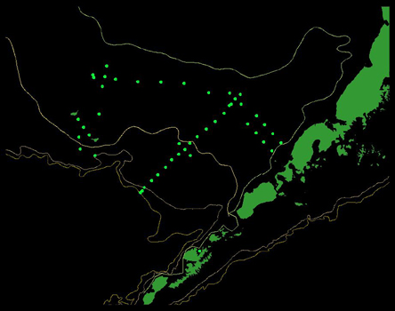
Table 1 Station Positions
| Operation |
LatDeg |
LatMin |
LongDeg |
LongMin |
DecLat |
DecLong |
| Dutch |
53 |
55 |
-166 |
31 |
53.9167 |
-166.5167 |
| SE
Middle Domain |
57 |
1.0 |
-164 |
13.0 |
57.0167 |
-164.2167 |
| SE
Middle Domain |
56 |
56.5 |
-163 |
50.0 |
56.9417 |
-163.8333 |
| Middle
Domain (Mooring 2) |
56 |
52.4 |
-164 |
3.2 |
56.8733 |
-164.0533 |
| SE
Middle Domain |
56 |
43.9 |
-163 |
53.0 |
56.7317 |
-163.8833 |
| SE
Middle Domain |
56 |
46.0 |
-164 |
20.0 |
56.7667 |
-164.3333 |
| Middle
Domain (Mooring 2) |
56 |
52.4 |
-164 |
3.2 |
56.8733 |
-164.0533 |
| 70
m isobath |
57 |
7.0 |
-165 |
0.0 |
57.1167 |
-165.0000 |
| 70
m isobath |
57 |
25.0 |
-165 |
52.0 |
57.4167 |
-165.8667 |
| 70
m isobath |
57 |
32.0 |
-166 |
44.0 |
57.5333 |
-166.7333 |
| 70
m isobath |
57 |
38.0 |
-167 |
37.0 |
57.6333 |
-167.6167 |
| 70
m isobath |
57 |
46.0 |
-168 |
28.0 |
57.7667 |
-168.4667 |
| NW
Middle Domain |
57 |
39.2 |
-169 |
1.2 |
57.6533 |
-169.0200 |
| Middle
Domain (Mooring 4) |
57 |
51.2 |
-168 |
52.1 |
57.8533 |
-168.8683 |
| NW
Middle Domain |
58 |
4.0 |
-168 |
43.8 |
58.0667 |
-168.7300 |
| NW
Middle Domain |
57 |
55.6 |
-169 |
19.3 |
57.9265 |
-169.3222 |
| NW
Middle Domain |
57 |
52.0 |
-169 |
18.0 |
57.8667 |
-169.3000 |
| Middle
Domain (Mooring 4) |
57 |
51.2 |
-168 |
52.1 |
57.8533 |
-168.8683 |
| Canyon Transport |
57 |
6.0 |
-169 |
19.2 |
57.1000 |
-169.3200 |
| Canyon Transport |
57 |
3.0 |
-170 |
8.5 |
57.0500 |
-170.1417 |
| Canyon Transport |
56 |
52.1 |
-169 |
58.3 |
56.8683 |
-169.9717 |
| Canyon Transport |
56 |
41.4 |
-169 |
48.2 |
56.6900 |
-169.8033 |
| Canyon Transport |
56 |
41.0 |
-170 |
12.4 |
56.6833 |
-170.2067 |
| Canyon Transport |
56 |
26.0 |
-170 |
13.2 |
56.4333 |
-170.2200 |
| Canyon Transport |
56 |
15.5 |
-169 |
42 |
56.2583 |
-169.7000 |
| Shelf
Break (CTD 1000 m) |
55 |
20.5 |
-168 |
15.2 |
55.3418 |
-168.2532 |
| Shelf
Break (CTD 500 m) |
55 |
22.3 |
-168 |
10.5 |
55.3712 |
-168.1747 |
| Shelf
Break (CTD 200 m) |
55 |
25.7 |
-168 |
4.4 |
55.4282 |
-168.0735 |
| Outer
Shelf Domain |
55 |
33.0 |
-167 |
46.0 |
55.5500 |
-167.7667 |
| Outer
Shelf Domain |
55 |
39.0 |
-167 |
30.0 |
55.6500 |
-167.5000 |
| Outer
Shelf Domain |
55 |
46.0 |
-167 |
10.0 |
55.7667 |
-167.1667 |
| Outer
Shelf Domain |
55 |
54.0 |
-166 |
54.0 |
55.9000 |
-166.9000 |
| Outer
Domain |
55 |
59.0 |
-166 |
35.0 |
55.9833 |
-166.5833 |
| Outer
Domain |
56 |
12.5 |
-166 |
30.0 |
56.2083 |
-166.5000 |
| Outer
Domain (Mooring 3) |
56 |
3.6 |
-166 |
20.1 |
56.0600 |
-166.3350 |
| Outer
Domain |
55 |
55.0 |
-166 |
10.0 |
55.9167 |
-166.1667 |
| Outer
Domain |
56 |
10.0 |
-166 |
6.0 |
56.1667 |
-166.1000 |
| Outer
Domain (Mooring 3) |
56 |
3.6 |
-166 |
20.1 |
56.0600 |
-166.3350 |
| Cross-shelf |
56 |
16.3 |
-165 |
46.4 |
56.2717 |
-165.7733 |
| Cross-shelf |
56 |
23.4 |
-165 |
23.5 |
56.3900 |
-165.3917 |
| Cross-shelf |
56 |
30.5 |
-164 |
59.9 |
56.5083 |
-164.9983 |
| Cross-shelf |
56 |
37.7 |
-164 |
36.3 |
56.6283 |
-164.6050 |
| Middle
Domain (Mooring 2) |
56 |
52.4 |
-164 |
3.2 |
56.8733 |
-164.0533 |
| AMA2 |
56 |
46.7 |
-164 |
14.7 |
56.7782 |
-164.2448 |
| AF16 |
56 |
25.4 |
-163 |
25.2 |
56.4237 |
-163.4192 |
| AF13 |
56 |
12.3 |
-163 |
11.7 |
56.2053 |
-163.1946 |
| AF10 |
55 |
59.1 |
-162 |
58.9 |
55.9857 |
-162.9813 |
| AF7 |
55 |
45.9 |
-162 |
46.2 |
55.7647 |
-162.7695 |
| AI7 |
55 |
38.6 |
-163 |
9.7 |
55.6442 |
-163.1613 |
| AI10 |
55 |
51.8 |
-163 |
22.4 |
55.8640 |
-163.3733 |
| AI13 |
56 |
5.0 |
-163 |
35.2 |
56.0838 |
-163.5867 |
| AI16 |
56 |
18.2 |
-163 |
49.1 |
56.3037 |
-163.8178 |
| Dutch |
53 |
55 |
-166 |
31 |
53.9167 |
-166.5167 |
|