PMEL Home Page FOCI Home Page


July 3, 2000
CRUISE REPORT

Cruise Number: MF00-05
FOCI Number: 4MF00
Ship: Miller Freeman

Area of Operations:

Gulf of Alaska, Bering Sea
Itinerary:
Kodiak, Alaska, April 18, 2000
T&G Dutch Harbor, Alaska, April 21, 2000
Dutch Harbor, Alaska, April 30, 2000
Participating Organizations:
NOAA - Pacific Marine Environmental Laboratory (PMEL)
NOAA - Alaska Fisheries Science Center (AFSC)
University of Alaska Fairbanks (UAF)
Chief Scientist:
William Parker M PMEL
Participating Scientists:
David Kachel M PMEL
Rick Miller M PMEL
Allen Macklin M PMEL
Susan Hendricks F UAF
Heloise Chenelot F UAF
Objectives of the Cruise:
  1. Recover and deploy moorings at the FOCI study areas of, site# 2, site# 3, site# 4 and site# 6.
  2. Recover and deploy AFSC CRAB moorings in the Pavlof Bay and Bristol Bay study areas.
  3. Conduct biological sampling in the project areas.
  4. Complete CTDs at Unimak Pass, the mooring locations and between the mooring sites.
Operations:
Mooring Deployments: 12
Pavlof Bay 1
Bristol Bay- 2
site# 2- 3
site# 3 3
site# 4- 2
site# 6- 1
Mooring Recoveries: 6
Pavlof Bay 1
Bristol Bay- 2
site# 2- 2
site# 6- 1
CTDs: 51
 Bongo Tows: 18
 Satellite Drifters: 3
Summary of Cruise:
The MF00-05 cruise itinerary and plot are included in the attachments below.

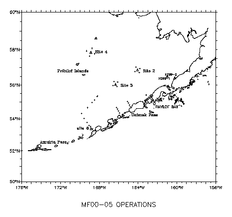
The Miller Freeman departed Kodiak on the 18th of April for a touch and go in Dutch Harbor to load scientists and mooring equipment for the Bering Sea operations. During the transit to Dutch Harbor the CRAB temperature mooring at Pavlof Bay was serviced by recovering the mooring, exchanging the instrumentation and re-deploying the mooring at the same location. The Unimak Pass CTD lines A and D were also completed before the T&G in Dutch Harbor on April 21st.

After the mooring equipment was loaded aboard the Miller Freeman, the ship departed Dutch Harbor for the Unimak Pass CTD line B to complete the third line of the Unimak Pas CTD box. After completing line B, the ship moved on to the Bristol Bay CRAB temperature mooring sites KC-1 and KC-2. Both moorings were recovered and re-deployed.

At site# 2, two subsurface moorings were recovered and a third mooring would not respond to release commands. A search and dragging attempt was tried. It appeared the mooring had been moved to about 0.6 mile east of its original position. This position was from a sonar sounding observed during the search.  A further attempt to recover this mooring will be made in September. Three moorings including a surface mooring were deployed at site# 2. The CTD grid of five CTDs was completed before leaving site# 2.

At site# 4, two moorings were deployed and the CTD grid was completed.

At site# 3, three moorings were deployed including a surface mooring. The same CTD grid was completed at site# 3.

The CTD line from the shelf break to mooring site# 6 was completed. Mooring 99BS-6 was recovered and re-deployed. Three Seimac Drifting Buoys were deployed on the transit from site# 6 to Unimak Pass.

CTDs at Unimak Pass Line A were again completed before returning to Dutch Harbor to complete the MF00-05 cruise.

Acknowledgments:
We would like to thank the officers and crew of the Miller Freeman for their efforts to complete the PMEL/AFSC operations on MF00-05.
Attachments:
 Cruise Intinerary
Activity Latitude      Longitude      Dist. Spd Trans On Sta Arrive (Local) Depart
              (nm) (kts) (hrs) (hrs) Date / Time Date / Time
Depart Kodiak 57° 44' N 152° 30' W           18-Apr 14:00
CTD/Recover- Pavlof Bay 55° 11' N 161° 41' W 340.4 10.0 34.0 2.0 20-Apr 00:02 20-Apr 02:02
Deployment/CTD- Pavlof Bay 55° 11' N 161° 41' W 0.0 10.0 0.0 2.0 20-Apr 02:02 20-Apr 04:02
CTD/Bongo-Unimak Pass-A 54° 26.7 N 164° 59.7 W 122.8 10.0 12.3 1.0 20-Apr 16:18 20-Apr 17:18
CTD/Bongo-Unimak Pass-A 54° 24.8 N 165° 08.4 W 5.4 10.0 0.5 1.0 20-Apr 17:51 20-Apr 18:51
CTD/Bongo-Unimak Pass-A 54° 22.3 N 165° 16.7 W 5.4 10.0 0.5 1.0 20-Apr 19:23 20-Apr 20:23
CTD/Bongo-Unimak Pass-A 54° 20.2 N 165° 25.4 W 5.5 9.5 0.6 1.0 20-Apr 20:58 20-Apr 21:58
CTD/Bongo-Unimak Pass-D 54° 21.6 N 165° 56.0 W 17.9 9.5 1.9 1.5 20-Apr 23:51 21-Apr 01:21
CTD/Bongo-Unimak Pass-D 54° 28.1 N 166° 02.0 W 7.4 9.5 0.8 1.5 21-Apr 02:07 21-Apr 03:37
CTD/Bongo-Unimak Pass-D 54° 34.8 N 166° 07.6 W 7.4 9.5 0.8 1.5 21-Apr 04:25 21-Apr 05:55
CTD/Bongo-Unimak Pass-D 54° 41.4 N 166° 14.2 W 7.6 9.5 0.8 1.5 21-Apr 06:43 21-Apr 08:13
T&G Dutch Harbor 53° 55' N 166° 31' W 47.9 10.0 4.8 9.0 21-Apr 13:00 21-Apr 22:00
CTD-Unimak Pass-B 54° 43.2 N 164° 46.8 W 77.8 10.0 7.8 1.0 22-Apr 05:47 22-Apr 06:47
CTD-Unimak Pass-B 54° 49.2 N 164° 53.4 W 7.1 10.0 0.7 1.0 22-Apr 07:30 22-Apr 08:30
CTD-Unimak Pass-B 54° 56.1 N 164° 59.1 W 7.6 10.0 0.8 1.0 22-Apr 09:16 22-Apr 10:16
CTD-Unimak Pass-B 55° 03.0 N 165° 05.4 W 7.8 10.0 0.8 1.0 22-Apr 11:02 22-Apr 12:02
CTD/Recover- KC99-1 56° 25' N 160° 13' W 183.9 10.0 18.4 1.5 23-Apr 06:26 23-Apr 07:56
Deployment/CTD- KC99-1 56° 25' N 160° 13' W 0.1 10.0 0.0 1.5 23-Apr 07:56 23-Apr 09:26
CTD/Recover- KC99-2 56° 30' N 161° 00' W 26.6 10.0 2.7 0.8 23-Apr 12:06 23-Apr 12:54
Deployment- KC00-2/CTD/RCM-9Turbidity  56° 30' N 161° 00' W 0.1 10.0 0.0 1.5 23-Apr 12:54 23-Apr 14:24
CTD/Bongo (BS2-SE) 56° 43.9 N 163° 53.0 W 96.1 12.0 8.0 1.2 23-Apr 22:25 23-Apr 23:37
CTD/Bongo (BS2-SW) 56° 46.0 N 164° 20.0 W 15.0 12.0 1.2 1.0 24-Apr 00:52 24-Apr 01:52
CTD/Bongo (BS2-NE) 56° 56.5 N 163° 50.0 W 19.5 12.0 1.6 1.0 24-Apr 03:29 24-Apr 04:29
CTD/Bongo (BS2-NW) 57° 01.0 N 164° 13.0 W 13.3 12.0 1.1 1.0 24-Apr 05:36 24-Apr 06:36
CTD/Recover- 00BS-2A 56° 52.6 N 164° 03.4 W 9.9 12.0 0.8 2.0 24-Apr 07:25 24-Apr 09:25
Search- 99BS-2C 56° 52.5 N 164° 03.0 W 0.2 10.0 0.0 4.0 24-Apr 09:27 24-Apr 13:27
Recover- 99BSP-2F 56° 52.4 N 164° 03.2 W 0.1 10.0 0.0 1.0 24-Apr 13:28 24-Apr 14:28
Deployment- 00BSM-2 56° 52.5 N 164° 03.0 W 0.1 10.0 0.0 2.2 24-Apr 14:29 24-Apr 16:41
Deployment- 00BSP-2S 56° 52.5 N 164° 03.0 W 0.0 10.0 0.0 1.5 24-Apr 16:41 24-Apr 18:11
Deployment- 00BSSST-2S/CTD /Bongo 56° 52.5 N 164° 03.1 W 0.1 10.0 0.0 1.4 24-Apr 18:11 24-Apr 19:35
Dragging- 99BS-2C 56° 52.5 N 164° 03.0 W 0.1 10.0 0.0 3.6 24-Apr 19:35 24-Apr 23:11
Deployment 00BS-4 57° 51.1 N 168° 52.4 W 166.7 11.5 14.5 1.5 25-Apr 13:41 25-Apr 15:11
Deployment/CTD/Bongo 00BSP4 57° 51.1 N 168° 52.4 W 0.0 11.5 0.0 1.5 25-Apr 15:11 25-Apr 16:41
CTD (BS4) 57° 55.6 N 169° 19.3 W 15.0 11.0 1.4 0.8 25-Apr 18:03 25-Apr 18:51
CTD (BS4) 58° 04.0 N 168° 43.8 W 20.6 11.5 1.8 0.6 25-Apr 20:38 25-Apr 21:14
CTD (BS4) 57° 46.0 N 168° 28.0 W 19.9 11.5 1.7 0.6 25-Apr 22:58 25-Apr 23:34
CTD (BS4) 57° 39.2 N 169° 01.2 W 19.0 11.5 1.7 0.6 26-Apr 01:13 26-Apr 01:49
CTD/Bongo (BS3) 56° 12.5 N 166° 30.0 W 119.7 11.7 10.2 0.6 26-Apr 12:02 26-Apr 12:38
CTD/Bongo (BS3) 56° 10.0 N 166° 06.0 W 13.6 11.0 1.2 0.8 26-Apr 13:53 26-Apr 14:41
Deployment 00BSM-3 56° 03.0 N 166° 20.0 W 10.5 11.0 1.0 2.0 26-Apr 15:38 26-Apr 17:38
Deployment 00BSP-3 56° 03.0 N 166° 20.0 W 0.0 11.0 0.0 1.0 26-Apr 17:38 26-Apr 18:38
Deployment 00BSSST-3S/CTD/Bongo 56° 03.0 N 166° 20.0 W 0.0 11.0 0.0 1.8 26-Apr 18:38 26-Apr 20:26
CTD/Bongo (BS3) 55° 55.0 N 166° 10.0 W 9.8 11.0 0.9 1.5 26-Apr 21:19 26-Apr 22:49
CTD/Bongo (BS3) 55° 59.0 N 166° 35.0 W 14.6 11.0 1.3 1.5 27-Apr 00:08 27-Apr 01:38
CTD/Bongo-500 meters  55° 22.3 N 168° 10.5 W 65.2 11.0 5.9 1.5 27-Apr 07:34 27-Apr 09:04
Equipment Repair (SeaCat) 55° 22.3 N 168° 10.5 W 0.0 11.0 0.0 3.0 27-Apr 09:04 27-Apr 12:04
CTD/Bongo-1000 meter  55° 20.5 N 168° 15.2 W 3.2 11.0 0.3 2.1 27-Apr 12:21 27-Apr 14:27
CTD/Bongo 55° 07.0 N 168° 29.0 W 15.6 11.0 1.4 2.0 27-Apr 15:53 27-Apr 17:53
CTD 54° 58.0 N 168° 45.0 W 12.8 11.0 1.2 1.8 27-Apr 19:03 27-Apr 20:51
CTD 54° 40.0 N 169° 12.0 W 23.8 11.0 2.2 1.5 27-Apr 23:00 28-Apr 00:30
CTD 54° 20.0 N 169° 50.0 W 29.8 11.0 2.7 1.7 28-Apr 03:13 28-Apr 04:55
CTD 54° 02.0 N 169° 34.0 W 20.3 11.0 1.8 1.8 28-Apr 06:46 28-Apr 08:34
CTD 53° 47.0 N 169° 16.0 W 18.4 11.3 1.6 1.5 28-Apr 10:11 28-Apr 11:41
CTD 53° 36' N 169° 04' W 13.1 11.2 1.2 1.5 28-Apr 12:51 28-Apr 14:21
CTD 53° 31.0 N 168° 55.0 W 7.3 11.2 0.7 1.7 28-Apr 15:00 28-Apr 16:42
CTD/Recovery- 99BS-6  53° 24.3 N 168° 51.2 W 7.1 11.2 0.6 2.0 28-Apr 17:20 28-Apr 19:20
Deployment- 00BS-6/CTD 53° 24.3 N 168° 51.2 W 0.0 11.0 0.0 3.2 28-Apr 19:20 28-Apr 22:32
Deploy Seimac Buoy(mim. depth 400M) 53° 24' N 168° 51' W 0.3 11.0 0.0 0.1 28-Apr 22:34 28-Apr 22:40
CTD-500meter? 53° 22.0 N 168° 42.0 W 5.7 11.0 0.5 1.0 28-Apr 23:11 29-Apr 00:11
Deploy Seimac Buoy(mim. depth 400M) 53° 40' N 167° 41' W 40.5 11.0 3.7 0.1 29-Apr 03:52 29-Apr 03:58
Deploy Seimac Buoy(mim. depth 400M) 54° 30.0 N 166° 04.0 W 75.7 11.0 6.9 0.1 29-Apr 10:51 29-Apr 10:57
CTD/Bongo-Unimak Pass-A 54° 26.7 N 164° 59.7 W 37.5 4.4 8.5 0.4 29-Apr 19:29 29-Apr 19:53
CTD/Bongo-Unimak Pass-A 54° 24.8 N 165° 08.4 W 5.4 10.0 0.5 0.7 29-Apr 20:25 29-Apr 21:07
CTD/Bongo-Unimak Pass-A 54° 22.3 N 165° 16.7 W 5.4 10.0 0.5 0.7 29-Apr 21:40 29-Apr 22:22
CTD/Bongo-Unimak Pass-A 54° 20.2 N 165° 25.4 W 5.5 10.0 0.5 0.7 29-Apr 22:55 29-Apr 23:37
Arrive Dutch Harbor 53° 55' N 166° 31' W 46.2 11.0 4.2   30-Apr 03:49  

 Mooring Plot
MF00-05 mooring locations


Fisheries-Oceanography Coordinated Investigations

NOAA | Pacific Marine Environmental Laboratory | Alaska Fisheries Science Center

Seattle, WA 98115
FOCI Coordinator
Disclaimer | Privacy Policy