1.3 NOAA /PMEL Operations Contact:
LCDR Michele Bullock
NOAA/PMEL
7600 Sand Point Way NE
Seattle, WA 98115
(206) 526-4485
1.4 Program Contacts:
Dr. Phyllis Stabeno
NOAA/PMEL
7600 Sand Point Way NE
Seattle, WA 98115
(206) 526-6453
Phyllis.Stabeno@noaa.gov
2.0. OPERATIONS:
2.1. SUMMARY OF ACTIVITIES:
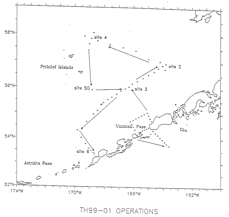
TGT-99-01 cruise will conduct mooring, CTD and Bongo net tow operations
as described:
1. Site 3: recover one mooring (subsurface) and deploy one mooring (subsurface).
2. Site 2: recover three moorings (subsurface) and deploy four moorings
(subsurface).
4. St. George Island: deploy one mooring (subsurface).
Mooring calibration CTD casts will be completed before each mooring
recovery and after each mooring deployment.
Mooring Operations: (see Appendices)
CTD lines are planned at Unimak Pass and between mooring sites 3 and
2, 2 and 4, 3 and 6 (see Appendices).
Bongo net tows will be completed at selected CTD locations (see Appendices).
In the event that conditions prohibit mooring deployments/ recoveries,
operations will focus on CTD lines to be selected by the Chief Scientist.
PMEL/FOCI requests that the mooring equipment recovered on TGT-99-01
remain on the Thompson until the ship's return to Seattle in February,1999.
2.2 PROCEDURES FOR OPERATIONS:
The following are operations to be conducted on this cruise:
Mooring calibration CTD casts will be completed before each mooring
recovery and after each mooring deployment.
Details and estimated times of these operations are specified in the
Appendices.
TGT-99-01 cruise operations will begin at east of Unimak Pass with the
IOS CTD line. PMEL CTD lines A, D, C and B in and west of Unimak Pass will
the next operations. Biological samples to be collected on lines A & D
only.
After completing the Unimak CTD lines the Thompson will transit to pickup
the CTD line southwest of site 3 with one CTD before the deployment of
the University of Alaska Sediment Trap mooring (F-99BSST-3S) at site 3.
The CTD/bongo grid around mooring site 3 will be competed. The CTD line
from site 3 to site 2 will be the completed next. At site 2, three moorings
will be recovered (F-98BS-2C,F-98BSP-2F, F 98BSST-2F). Four moorings (F-99BS-2A,
F-99BS-2B, F-99BSP-2S, F-99BSST-2S, will be deployed. The CTD/bongo grid
around mooring site 2 will be completed. The CTD line from site 2 to site
4 and the CTD/bongo grid at site 4 will be completed if sea ice conditions
allow the Thompson access to the area.
South of St. George Island, one mooring (F-99SG-4) will be deployed.
The Thompson will then transit to the CTD line south of site 3 and complete
the final CTD line between site 3 and site 6. This will complete the Bering
Sea Mooring and CTD operations.
Mooring diagrams will be provided to ship by the Chief Scientist before
cruise .
3.0. FACILITIES AND EQUIPMENT:
The following systems and their associated support services are
essential to the cruise. Sufficient consumable, back-up units, and on-site
spares and technical support must be in place to assure that operational
interruptions are minimal. All measurement instruments are expected to
have current calibrations, and all pertinent calibration information shall
be included in the data package.
3.1 Equipment and Capabilities to be Provided by the Ship:
Oceanographic winch with slip rings and 3-conductor cable terminated
for CTD,
Sea-Bird 911 plus CTD system with stand ,
(The CTD system should include underwater CTD, weights, and pinger and
there should be one deck unit and tape recorder ),
10-liter sampling bottles for use with rosette (10 plus 4 spares),
EK-500 or suitable water depth indication to 1500 meters,
Oceanographic winch for bongo net (and other nets when used) with slip
rings and 3-conductor cable terminated for the SeaCat,
Wire-angle indicator and readout for oceanographic winch,
Wire speed indicators and readout for oceanographic winches,
For meteorological observations: 2 anemometers (one R. M. Young system
interfaced to the SCS), calibrated air thermometer (wet-and dry-bulb) and
a calibrated barometer and/or barograph,
Freezer space for storage of biological and chemical samples (blast
and storage freezers),
Simrad EQ-50 echo sounder ,
RDI shipboard ADCP,
Laboratory space with exhaust hood, sink, lab tables and storage space,
Sea-water hoses and nozzles to wash nets (quarterdeck and aft deck),
Adequate deck lighting for night-time operations,
Navigational equipment including GPS and radar ,
Safety harnesses for working on quarter deck and fantail,
Capstan or winch system for recovery of moorings
3.2 Equipment to be Provided by the Project:
Sea-Bird SBE-19 Seacat system (primary system),
PMEL PC with SEASOFT software for CTD data collection and processing,
Fluorometer, light meter, and chlorophyll absorbance meter (ChlAM) to
be mounted on CTD,
60-cm bongo sampling arrays,
20 cm bongo arrays,
Calvet arrays,
Spare wire angle indicator,
Subsurface moorings, including anchors, floatation and instrumentation,
Miscellaneous scientific sampling and processing equipment ,
Discrete Sample Data Base computer, software and forms.
4.0 MISCELLANEOUS:
4.1. Hazardous Materials:
1. The Chief Scientist shall be responsible for complying with NC Instruction
6280A, Hazardous Waste; policy, guidance, and training, dated February
4, 1991, paragraph 7.g and paragraph 9. By federal law, the ship may not
sail without a complete inventory of MSDS, and appropriate neutralizing
agents, buffers, and/or absorbent in amounts adequate to address spills
of a size equal to the amount aboard.
5.0 COMMUNICATIONS:
5.1 Important phone numbers, fax numbers and e-mail addresses:
PMEL/CARD Fax: (206) 526-6485
PMEL/ADMIN Fax: (206) 526-6815
6.0. APPENDICES:
1. CTD and mooring locations and schedule
2. CTD and mooring plot
3. Hazardous Materials information