|
March 16, 1999
FINAL CRUISE INSTRUCTIONS
NOAA Ship MILLER FREEMAN
Cruise No: MF99-05
FOCI No: 2MF99
Applicability:
These instructions, with "FOCI
Standard Operating Instructions for NOAA Ship MILLER FREEMAN, 1999"
present complete information for this cruise.
Area:
Bering Sea
Itinerary:
April 21,1999: Dutch Harbor, Alaska
May 1, 1999: Dutch Harbor, Alaska
Participating organizations:
NOAA - Pacific Marine Environmental Laboratory (PMEL)
NOAA - Alaska Fisheries Science Center (AFSC)
University of Alaska, Fairbanks (UAF)
CRUISE DESCRIPTION:
Fisheries-Oceanography Coordinated Investigations (FOCI) is
an effort by NOAA and associated academic scientists. At present, FOCI
consists of a Shelikof Strait (western Gulf of Alaska) walleye pollock
project, and a NOAA Coastal Ocean Program project: Southeast Bering Sea
Carrying Capacity. FOCI also supports associated projects, such as the
Arctic Research Initiative, U.S. GLOBEC, and NSF Inner Front Study, that
address scientific issues related to FOCI's. FOCI's goal is to understand
the effects of abiotic and biotic variability on ecosystems of the North
Pacific Ocean and Bering Sea in order to discern the physical and biological
processes that determine recruitment variability of commercially valuable
finfish and shellfish stocks in Alaskan waters.
CRUISE OBJECTIVES:
1. Recover and deploy moorings at the FOCI study areas of Nunivak
Island, St. George Island, site #2, and site #6.
2 Recover and deploy AFSC and NSF moorings at the Bristol Bay study
areas.
3. Conduct biological sampling in project areas.
4. Complete CTD lines at Unimak Pass and between mooring sites.
1.0. PERSONNEL
1.1. Chief Scientist:
| William Parker |
M |
PMEL |
| 206-526-6180 |
|
|
The Chief Scientist has the authority to revise or alter the technical
portion of the instructions as work progresses provided that, after consultation
with the Commanding Officer, it is ascertained that the proposed changes
will not: (1) jeopardize the safety of personnel or the ship; (2) exceed
the overall time allotted for the project; (3) result in undue additional
expenses; (4) alter the general intent of these project instructions.
1.2 Participating Scientists
| Carol DeWitt |
F |
PMEL |
| David Kachel |
M |
PMEL |
| Rick Miller |
M |
PMEL |
| Elaina Jorgensen |
F |
AFSC |
| Chris Baier |
F |
AFSC |
| Stacey Smith |
F |
Univ. of Alaska |
| TBN |
? |
Univ. of Alaska |
1.3 NOAA Pacific Marine Center Operations Contact:
Larry Mordock
NOAA/PMC (PMC1x4)
1801 Fairview Ave. East
Seattle, WA 98102-3767
(206) 553 - 4764
Larry.Mordock@noaa.gov
1.4 Program Contacts:
Dr. Phyllis Stabeno
PMEL
7600 Sand Point Way NE
Seattle, WA 98115
(206) 526-6453
Phyllis.Stabeno@noaa.gov |
Dr. Art Kendall
AFSC
7600 Sand Point Way NE
Seattle, WA 98115
(206) 526-4108
|
2.0. OPERATIONS
A standard oceanographic watch will be utilized which consists
of a winch operator, a scientific staff of three and a Survey Tech on deck.
Operations will be conducted 24 hours per day.
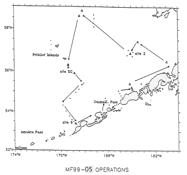
2.1. SUMMARY OF ACTIVITIES:
The operations during Cruise MF99-05 will consist of a combination
of mooring recoveries, mooring deployments, CTD casts, Bongo net tows along
with pollock egg sampling through out the cruise. Seimac Drifting Buoys
will be deployed during the cruise at the discretion of the Chief Scientist.
CTD lines are planned at Unimak Pass, the mooring locations and between
sites #3 and #6. Other CTDs will also be completed.
Mooring Operations: (see Appendices)
Slime Bank- Deploy four moorings.
Bristol Bay- Recover two moorings. Deploy two moorings.
Cape Newenham- Deploy one mooring
Site #2- Recover three moorings. Deploy two moorings.
Nunivak Is.- Deploy two moorings.
St. George Is.- Recover four moorings. Deploy three moorings.
Site #3- No mooring operations.
Site #6- Recover one mooring. Deploy one mooring.
In the event that conditions prohibit mooring deployments/ recoveries,
operations will focus on CTD lines to be selected by the Chief Scientist.
2.2 PROCEDURES FOR OPERATIONS:
The following are operations to be conducted on this cruise.
The procedures for these operations are listed in the FOCI Standard Operating
Instructions (SOI). Operations not addressed in the SOI and changes to
standard procedures are addressed below.
Mooring calibration CTDs will be completed before each mooring recovery
and after each mooring deployment.
Details and times of these operations are specified in the Appendices.
CTD operations will begin at Unimak Pass with the lines in and on the
Bering Sea side of the Pass. Mooring operations will begin northeast of
Unimak Pass in the Slime Banks area with the deployment of three Innerfront
mooring (one surface, three subsurface). Moving further northeast into
Bristol Bay mooring operations will consist of the recovery and deployment
of the AFSC CRAB Program Moorings (two subsurface). After completing the
CRAB mooring work the ship will transit to an Innerfront mooring site between
Cape Newenham and site #2 and deploy one mooring (subsurface). At Site
#2, mooring recoveries (three subsurface), deployments (one surface, one
subsurface), CTDs and Bongo tows will be completed with the CTD/ Bongo
grid around the mooring locations.
Leaving Site #2 the Miller Freeman will transit to the Innerfront Nunivak
area. At Nunivak Is. moorings will be deployed (two subsurface) with CTDs
after each deployment.
After completing the Nunivak operations we will move south to begin
the mooring work around St. Paul Is./St. George Is. This will involve mooring
recoveries(four subsurface) and mooring deployments (three subsurface).
Moving from the St. George operations, the ship will proceed to Site
#3 and complete the CTD/Bongo grid around the mooring site. There will
be no mooring operations at Site #3. The next operation will be the CTD
line south of Site #3 at the shelf break and south on the CTD/bongo line
to Site #6. At Site #6 the 1000 meter mooring (subsurface)will be recovered
and re-deployed. The CTD at mooring Site #6 and one other CTD will complete
the basin CTD line.
This will complete the planned operations for MF99-05.
Mooring recoveries/ deployments ( Mooring diagrams will be provided
to ship by chief scientist before cruise )
CTD/Water samples (SOI 2.2.1)
Chlorophyll samples (SOI 2.2.10)
Satellite tracked drifter buoy (SOI 2.2.11)
EK500 monitoring (SOI 2.2.12)
ADCP (SOI 2.2.13)
Radiometer (SOI 2.2.14)
Bongo tows ( SOI 2.2.2)
3.0. FACILITIES AND EQUIPMENT
The following systems and their associated support services
are essential to the cruise. Sufficient consumable, back-up units, and
on-site spares and technical support must be in place to assure that operational
interruptions are minimal. All measurement instruments are expected to
have current calibrations, and all pertinent calibration information shall
be included in the data package.
3.1 Equipment and Capabilities to be Provided by the Ship
Oceanographic winch with slip rings and 3-conductor cable terminated
for CTD,
EK-500,
Wire-angle indicator and readout for oceanographic winch,
Oceanographic winch for bongo net (and other nets when used) with slip
rings and 3-conductor cable terminated for the Seacat,
Sea-Bird 911 plus CTD system to be used with PMEL stand (primary system)
(The underwater CTD unit should have mounts compatible with the PMEL
CTD stand),
Sea-Bird 911 plus CTD system with stand (back up system),
(Each CTD system should include underwater CTD, weights, and pinger
and there should be one deck unit and tape recorder for the two systems),
10-liter sampling bottles for use with rosette (10 plus 4 spares),
For CTD field corrections: IAPSO water and AUTOSAL salinometer,
Sea-Bird SBE-19 Seacat system,
Wire speed indicators and readout for quarterdeck, Rowe and Marco winches,
For meteorological observations: 2 anemometers (one R. M. Young system
interfaced to the SCS), calibrated air thermometer (wet-and dry-bulb) and
a calibrated barometer and/or barograph,
Freezer space for storage of biological and chemical samples (blast
and storage freezers),
Simrad EQ-50 echo sounder ,
JRC JFV-200R color sounder recorder,
RDI ADCP written to SCS and Iomega Zip drives,
Use of Pentium PC in DataPlot for data analysis,
SCS (Shipboard Computer System),
Stern platform in place,
Laboratory space with exhaust hood, sink, lab tables and storage space,
Sea-water hoses and nozzles to wash nets (quarterdeck and aft deck),
Adequate deck lighting for night-time operations,
Navigational equipment including GPS and radar ,
Safety harnesses for working on quarter deck and fantail.
3.2 Equipment to be Provided by the Project
PMEL PC with SEASOFT software for CTD data collection and processing,
Fluorometer, light meter, and chlorophyll absorbance meter (ChlAM) to
be mounted on CTD,
CTD stand modified for attachment of fluorometer,
Conductivity and temperature sensor package to provide dual sensors
on the primary CTD,
CTD rosette sampler,
Seimac O2L Drifting Buoys,
60-cm bongo sampling arrays,
20 cm bongo arrays,
Spare wire angle indicator,
Surface moorings (FOCI bio-physical platforms),
Subsurface moorings,
Miscellaneous scientific sampling and processing equipment ,
Scientific ultra-cold freezer,
Discrete Sample Data Base software and forms.
3.3 Ship's Computer System (SCS)
The (SCS) shall operate throughout the cruise, acquiring and
logging data from navigation, meteorological, oceanographic, and fisheries
sensors. See FOCI Standard Operating Instructions for specific requirements.
4.0 DATA AND REPORTS
Data disposition, responsibilities and data requirements are
listed in the FOCI Standard Operating Instructions.
5.0 ADDITIONAL INVESTIGATIONS AND PROJECTS
5.3 Piggyback projects:
None at this time.
6.0 MISCELLANEOUS
6.5. Hazardous Materials:
The Chief Scientist shall be responsible for complying with NC Instruction
6280A, Hazardous Waste; policy, guidance, and training, dated February
4, 1991, paragraph 7.g and paragraph 9. By federal law, the ship may not
sail without a complete inventory of MSDS, and appropriate neutralizing
agents, buffers, and/or adsorbents in amounts adequate to address spills
of a size equal to the amount aboard.
7.0 COMMUNICATIONS
7.4 Important phone numbers, fax numbers and e-mail addresses:
PMEL/CARD Fax: (206) 526-6485
PMEL/ADMIN Fax: (206) 526-6815
AFSC/RACE Fax: (206) 526-6723
MILLER FREEMAN COMSAT (government account numbers): These are much
cheaper than Inmarsat direct numbers and should always be used first.
800-678-0872, after voice prompt dial customer ID# (Voice)
800-678-0872, after voice prompt dial customer ID# (Fax)
PI's should establish their ID#'s with their program.
Inmarsat (direct numbers)
B Voice: 011-872-330-394-113
B Fax: 011-872-330-114
M Voice: 011-872-761-267-346
011-872-761-267-347
M Fax: 011-872-761-267-348
CELLULAR: 206-660-7167
KODIAK ROAMER: 907-528-7626
DUTCH HARBOR ROAMER: 907-391-7626
(First dial the roamer, wait for dial tone, then dial cellular number.)
8.0. APPENDICES
1. CTD
and mooring locations
2. CTD
and mooring plot
| 