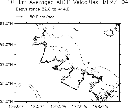
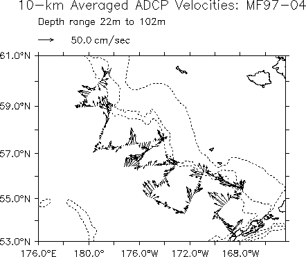
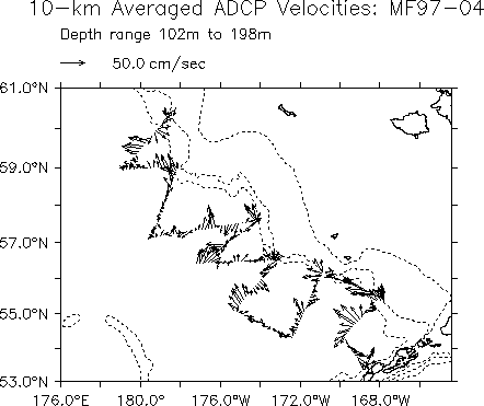
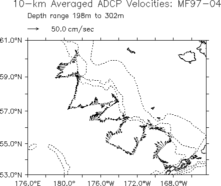
Cruise MF97-04 (FOCI 4MF97) was conducted aboard the NOAA Ship Miller Freeman from 28 March to 13 April, 1997, under the direction of Dr. E.D. Cokelet, Chief Scientist. One of the primary cruise objectives was to study the Bering Slope Current and how it relates to the associated "green belt" of enhanced biological activity at the boundary between the Bering Sea basin and the continental shelf. CTD (conductivity-temperature-depth) and ADCP (acoustic Doppler current profiler) observations were made to provide information on the current's speed and location. Deep geostrophic currents will be referenced to the upper-ocean ADCP velocities in a manner similar to Cokelet, Schall, and Dougherty (1996). Water sample analyses by University of Alaska Fairbanks scientists will give phytoplankton species composition, standing stock, primary production, and nutrient estimates.
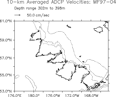
Preliminary ADCP data from cruise MF97-04 are presented here. Plots of water velocity vectors are from data collected and processed during this cruise and are not represented to be final products.
ADCP data were acquired with an RD Instruments (RDI) 153 kHz ADCP system. The transducer is mounted on the Miller Freeman's retractable centerboard, at a depth of 10 m. Acquisition and logging of the data were controlled by RDI DAS software, version 2.48, in conjunction with the University of Hawaii user-exit software UE4.
The acquistion software was configured to collect velocity data in 8 meter depth intervals ("bins"), for a maximum of 50 bins, corresponding to a maximum depth range of approximately 420 meters. The user-exit software controlled acquisition of primary navigation data from a precision Global Positioning System (Trimble PPS-GPS) satellite receiver, and the acquisition and processing of ship's attitude data from a GPS attitude determination unit (Ashtech 3DF).
ADCP Velocity data presented here have been corrected for gyrocompass error using a time series of comparisons between the gyro output and the Ashtech 3DF Attitude Determination Unit. A correction for transducer alignment has been applied. The ship's speed and position have been smoothed by referencing to the water track at 40-120 m.
Current vectors are averaged to 10-kilometer intervals along the ship track. Various vertical averaging results are offered here.
For further information on this research, contact
Edward.D.Cokelet@noaa.gov.
Last Modified September 11, 1997.
|
FOCI Project Office |