|
Joseph
Resing
Research Project:
Climate Variability and Predictability (CLIVAR)
CLIVAR project website: www.clivar.org
| |
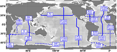
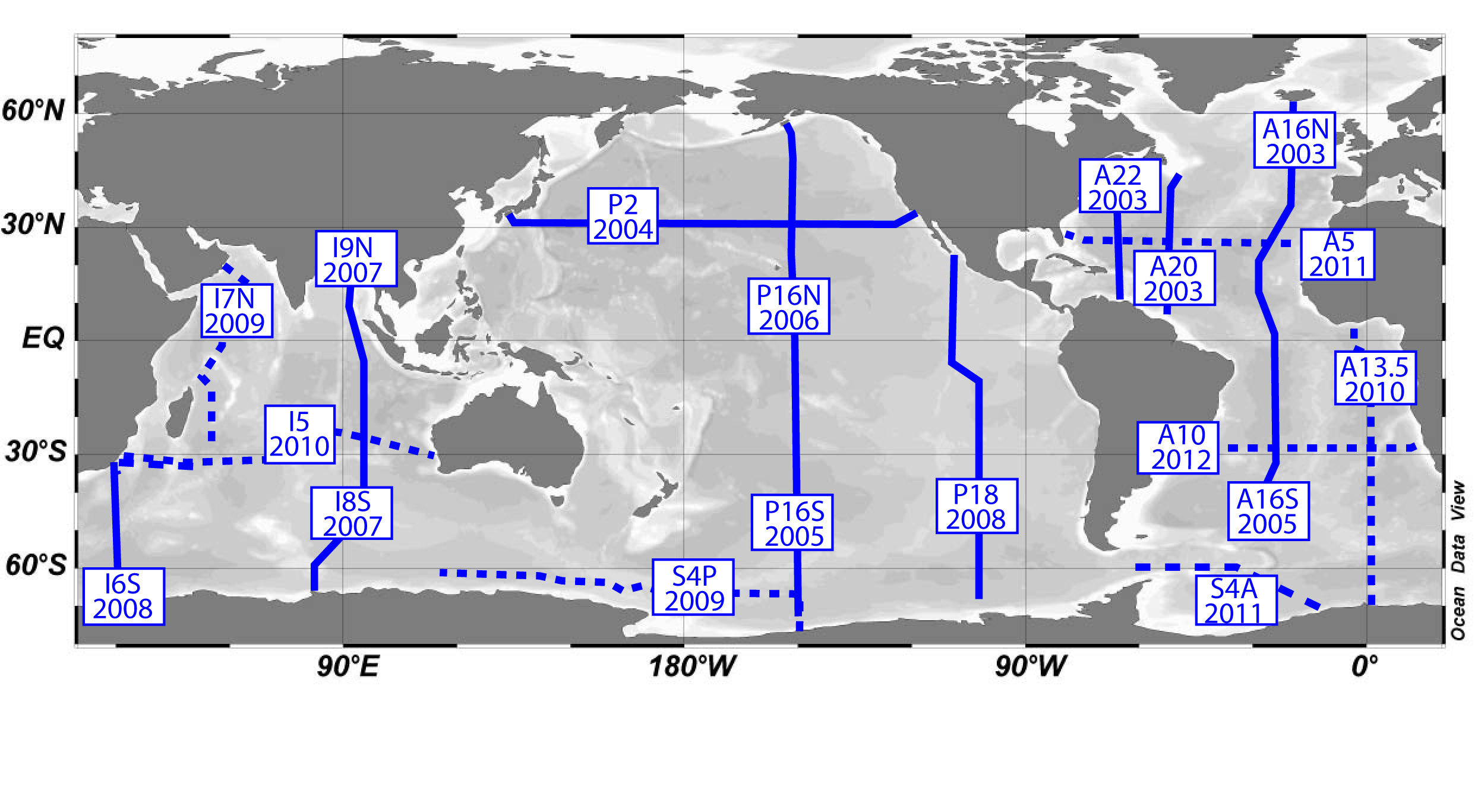
Figure 1. U.S. Repeat Hydrography cruises.
Samples have been taken from cruises A16N, P2, P16S and P16N. I8S,
I9N, I6S and either I7N or S4P will be sampled in the future. (click
for full size) |
Introduction
Atmospheric carbon dioxide concentrations
affect the earth’s radiation balance which is a defining component
of planetary equilibrium temperature and climate. Modeling the redistribution
of atmospheric carbon dioxide between atmospheric, oceanic and crustal
reservoirs is critical for understanding climate response to current
and future anthropogenic carbon dioxide releases and is paramount for
accurate prognostic climate models.
Transfer of carbon dioxide across the
atmospheric-oceanic boundary consists of two main components. First
, there is a physical component where dissolution of carbon dioxide
is moved into the ocean interior via mixing and entrainment. Second,
is a biological component, called the ‘biological pump,’ where
primary production within the euphotic zone fixes carbon dioxide
gas into organic carbon particles which are then exported to the
deep ocean and sediments. In the latter system there is a mounting
body of evidence that the rate of transfer of carbon from the surface
ocean to the crust is moderated by concentrations of biologically-available
Fe. Fe is an important element for photosynthesis but is also a trace
element in surface seawater and as a result controls the rate photosynthetic
organisms fix carbon dioxide in large High Nutrient, Low Chlorophyll
regions in the ocean.
 |
|
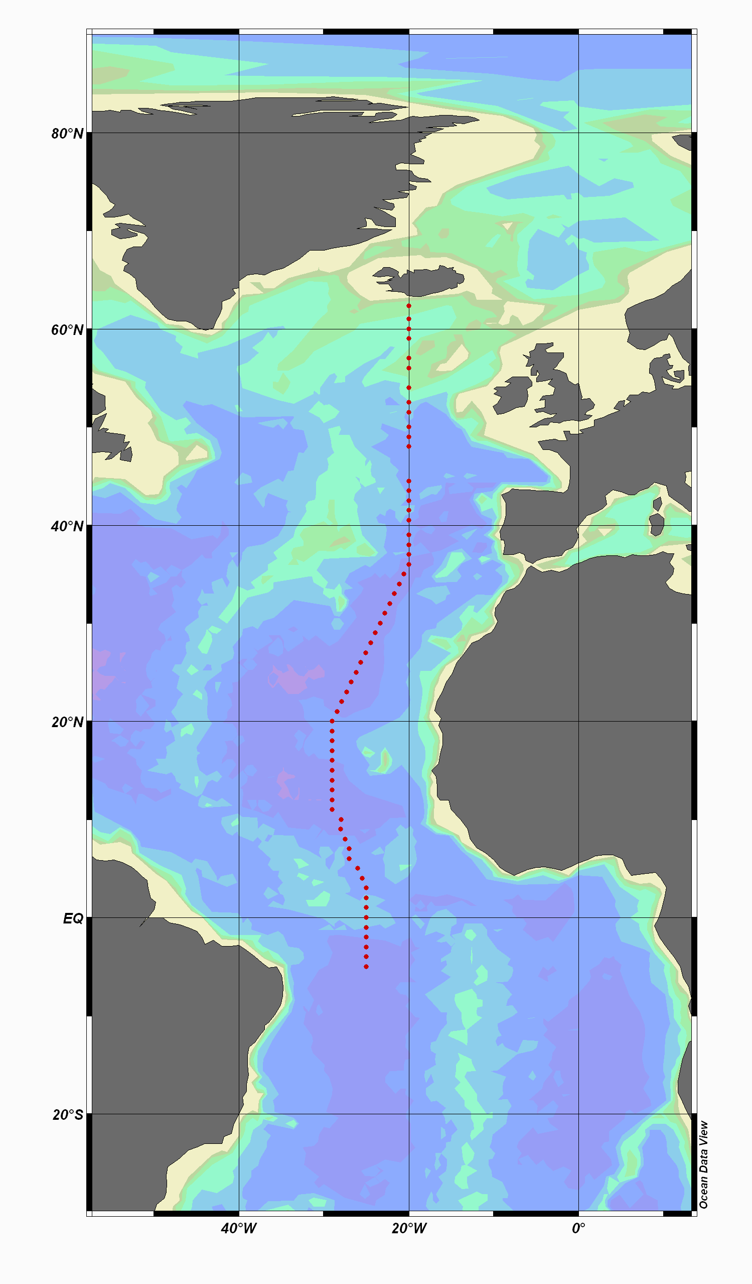
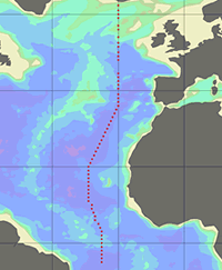
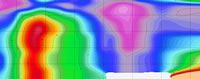
| Figure
2. Meridional Atlantic transect
along 20° W from the A16N
CLIVAR cruise in 2003. |
|
Thus, to better understand how the global
biogeochemical ocean carbon cycle operates it is important to investigate
and quantify all transport processes which deliver Fe and other trace
nutrients into the surface ocean as well as the factors controlling
them. This is particularly true for atmospheric transport and dissolution
of continentally derived mineral dust to surface ocean areas located
great distances from continental land masses. While other global
ocean studies such as WOCE and JGOFS have quantified the global distributions
of temperature, salinity, nutrients and a number of other tracers
there is a comparatively small pool of data for trace element distributions.
Furthermore, and most importantly, no measured data exists in the
literature on atmospheric dust loads over the open ocean -- only
estimates extrapolated from adjacent land based sampling sites, calculated
concentrations from shipboard measurements or estimates from particle
interceptor traps.
The CLIVAR/CO2 Repeat Hydrography program has provided
an opportunity to collect and measure surface water column profiles and
aerosol concentrations for trace elements.
| |
 |
| |
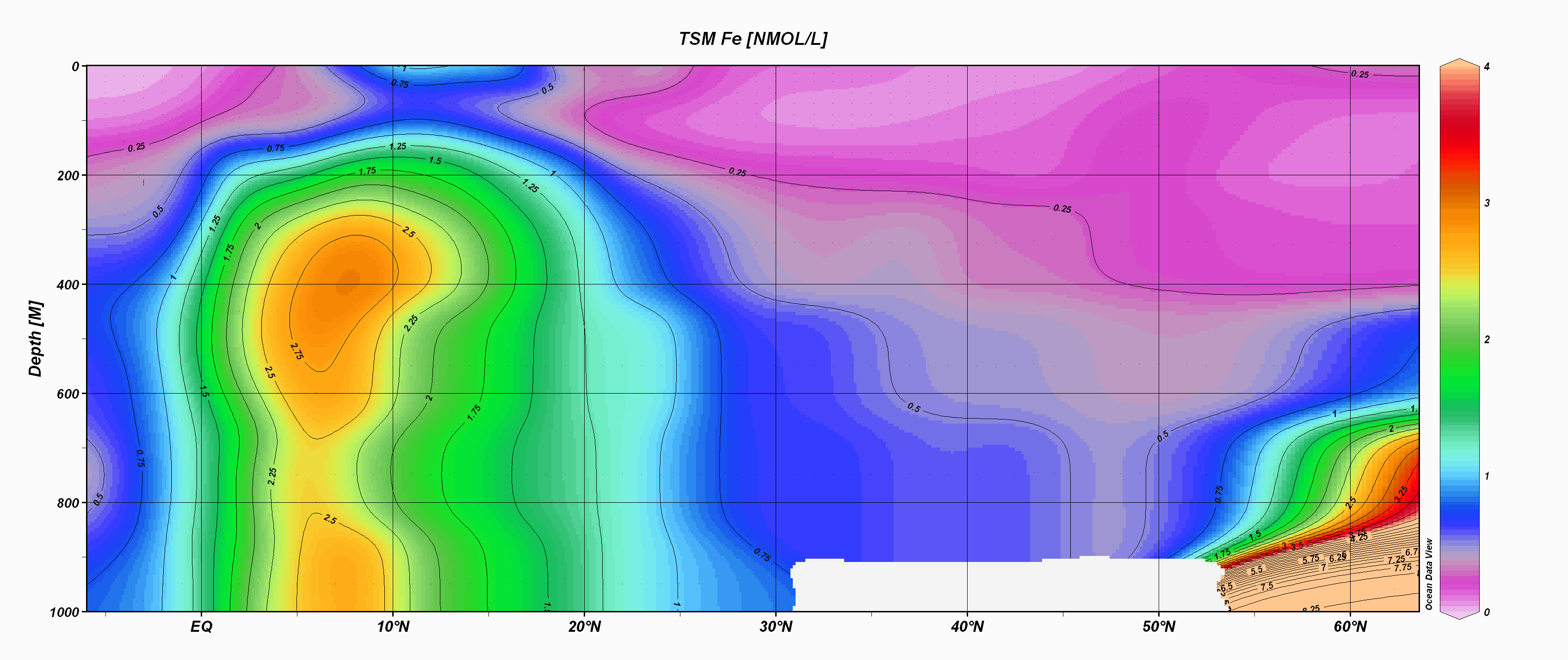
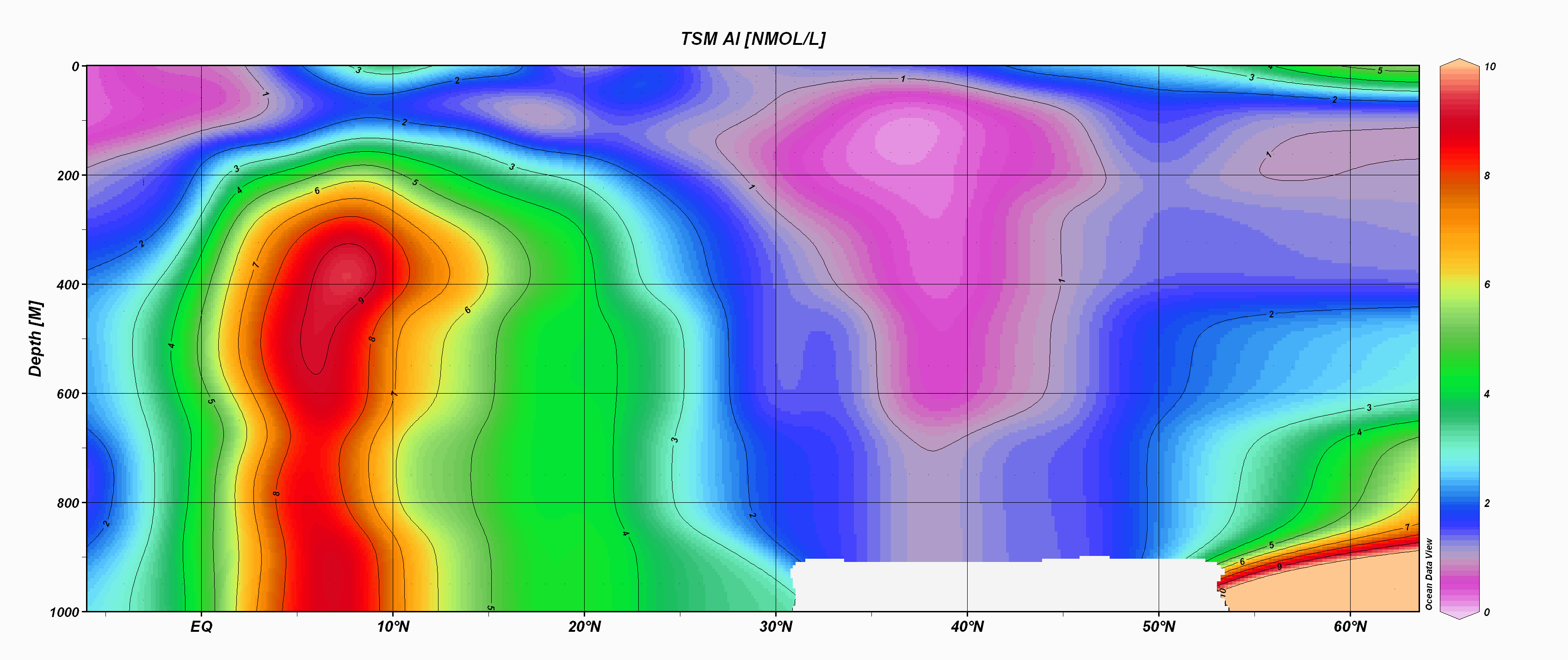
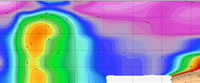
Figure
3 and 4. Contour plots of suspended particulate Al and Fe
from the A16N CLIVAR transect sampled in the summer of 2003. |
Basin-wide transects of dissolved
and particulate trace metal concentrations in solution as well as
total and soluble fractions of aerosols can be a powerful tool in
constraining ocean-atmosphere carbon models. Not only are many trace
elements bioactive (Mn, Fe, Co, Ni, Cu, Zn) but they can also be
used as tracers for particle scavenging processes (Al, Mn, Co, Pb)
and atmospheric input (Al, Si, Ti and Fe).
Research Goals
The Climate Variability and Predictability
program (CLIVAR) is an international, interdisciplinary research
effort focused on understanding seasonal to centennial variations in the
climate system. The US CLIVAR organization has created a Repeat Hydrography
program (Figure 1; http://ushydro.ucsd.edu/repeathydro_map.html )
which, “is driven by the need to monitor the changing patterns
of carbon dioxide (CO2) in the ocean and provide the necessary data
to support continuing model development that will lead to improved
forecasting for oceans and global climate.
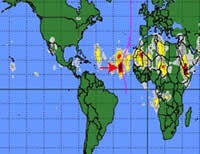 |
|
| Figure
5. Satellite image of airborne dust generated
from a Saharan dust storm. |
|
The WOCE/JGOFS survey during
the 1990s has provided a full depth, baseline data set against which
to measure future changes. By integrating the scientific needs in the
following five areas, major synergies and cost savings will be achieved.
These areas are of importance both for upcoming research programs,
such as CLIVAR and the U.S. GCRP Carbon Cycle Science Program (CCSP),
and for operational activities such as GOOS and GCOS.
In this regard,
consensus was reached at the First International Conference on Global
Observations for Climate, held in St. Raphael, France in October 1999,
that one component of a global observing system for the physical climate/CO2
system should include periodic observations of hydrographic variables,
CO2 system parameters and other tracers” (Smith and Koblinsky,
2000; http://ushydro.ucsd.edu/history_justification.html).
Within this framework we hope to elucidate the biogeochemical role
of dust in the world’s oceans by:
(1) Measuring the temporal and spatial variability and magnitude
of aerosol deposition into surface ocean waters as well as its subsequent
dissolution.
(2) Continue the work undertaken on previous CLIVAR cruises by mapping
the distributions of dissolved and particulate Fe, Al and other trace
elements. This will allow for evaluation that aerosol deposition
plays in maintaining trace element concentrations.
Data and Preliminary Result
Our role in the CLIVAR/CO2 Repeat Hydrography
is to collect, quantify and analyze data for dissolved particulate
and aerosol Fe, Al and other trace elements. Research efforts are conducted
in conjunction with Dr Chris Measures http://www.soest.hawaii.edu/oceanography/faculty/measures.html (
of the University of Hawaii (shipboard dissolved Al and Fe profiles
using flow injection analysis) and Dr William Landing, Florida State
University (http://ocean.fsu.edu/faculty/landing/landing.html (aerosol
collection and solubility experiments). This has produced large scale
data sets that can be used to ground-truth biogeochemical and coupled
ocean/atmospheric/climate models. Results have revealed many unknown
features regarding the distributions of dissolved and particulate Al
and Fe, as well as Fe aerosol chemistry not expressed in existing models.
Trace Element particulate distributions --
Participation in the 2003 CLIVAR U.S. Repeat
Hydrography A16 cruise produced a large and comprehensive dataset of trace
element distribution in the Northern Atlantic (Figure 2). Samples were
collected using a rosette based trace element sampling system. Sixty two
vertical profiles sampling 12 depths to 1000 meters were made every 60
Nautical miles. Suspended particulate matter was collected with 0.4 µm,
47mm PCTE TSM filters. Filters were analyzed using energy dispersive X-ray
fluorescence methods on a Spectro X-Lab 2000 X-ray Fluorescence Spectrometer.
Concentrations of AL, Si, P, S, K, Ca, Ti, V, Cr, Mn, Fe, Ni, Cu, Zn, Br
and Pb have been quantified. Figures 3 and 4 showcase the potential of
large, semi-synoptic basin wide transects. Particulate Al and Fe sections
from the A16 transect display coherent distributions, with elevated concentrations
in surface and intermediate waters beneath the main summertime track of
Saharan dust plume. Large summer storms transport Saharan dust to the North
Atlantic injecting the surface waters with trace elements (figure 5). Figure
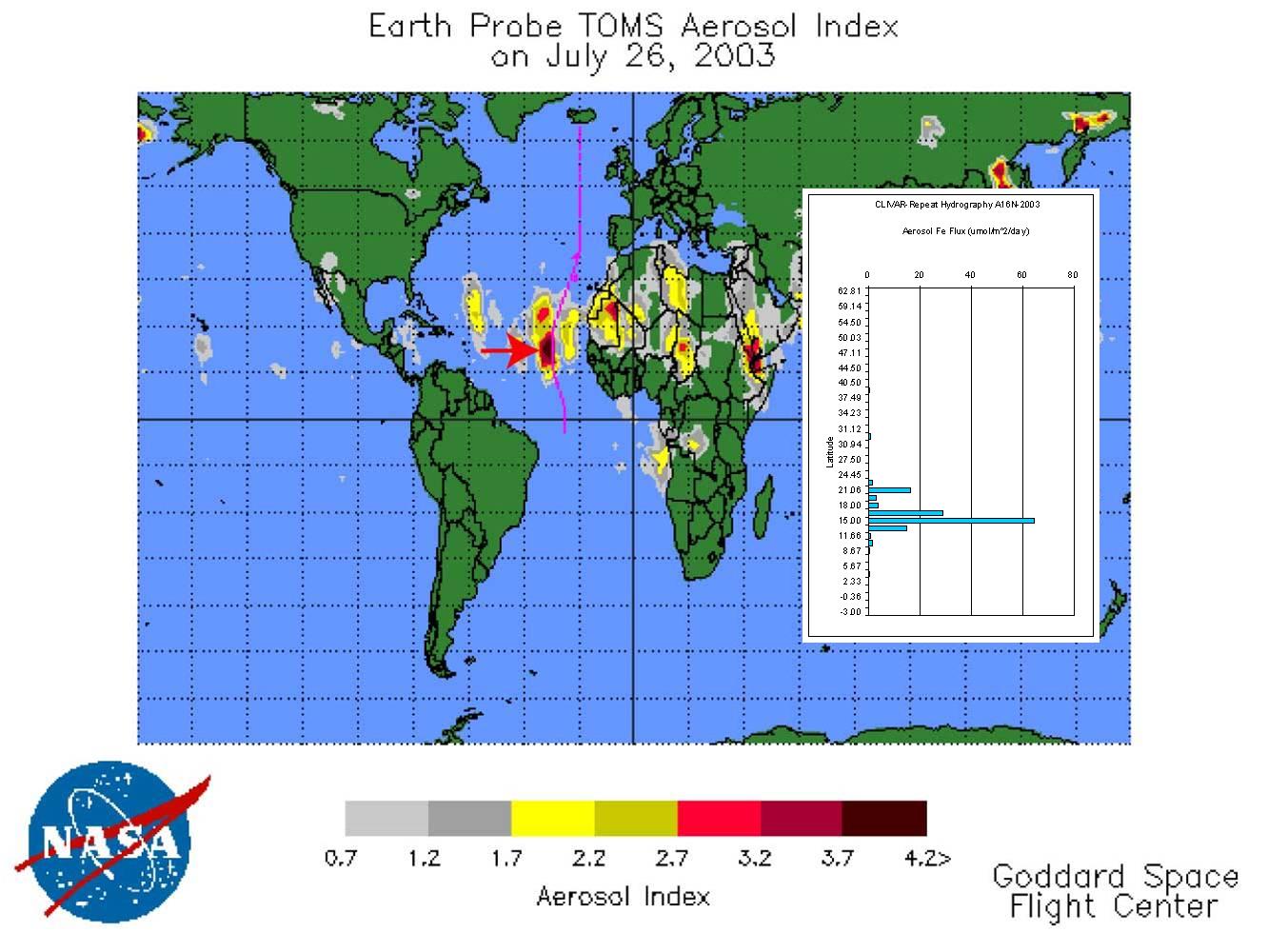
6 displays Aerosol Index for July 26, 2003 from the Goddard Space Flight
Center. The red arrow indicates the sample location in relation to a high
dust mass event. The inset characterizes Fe aerosol Flux versus Latitude.
Further studies are being conducted to constrain the impact of such deposition
by investigating aerosol Fe and Al solubility. See Buck et al. G3 Volume
7, number 4, April 2006. |
|