|
| |
||||||||||||||||
|
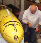
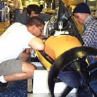
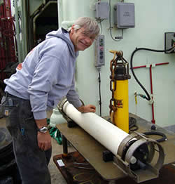 Matt Fowler preparing an OBH for redeployment. (click image for larger view) |
Just like earthquakes on land, earthquakes on the seafloor generate seismic waves that propagate through the Earth’s crust. However, the earthquakes typically associated with submarine volcanism are usually too small to be detected by seismometers on land, because they are just too far away. Fortunately, seafloor earthquakes also generate another type of wave, called a tertiary (or T-) wave. T-waves are sound waves that propagate from the seafloor into the water above (submarine earthquakes actually cause the seafloor to rumble). These sounds travel so efficiently in the ocean that small submarine earthquakes can be detected and located from distances up to thousands of kilometers away. Thus hydrophones can provide us more information about the seismicity at Axial Seamount than seismometers on land can.
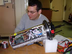
For this reason, some of the instruments we are using to monitor the activity at NeMO are Ocean Bottom Hydrophones (or OBH’s). An OBH consists of a hydrophone mounted on a platform anchored on the seafloor, an acoustic release that can let go of the anchor on command, and flotation to return the instrument to the surface at the end of a deployment. These OBHs can be deployed for up to 2 years. The Acoustic Monitoring Project of NOAA’s Pacific Marine Environmental Laboratory and Oregon State University first deployed OBHs at Axial Seamount in 2006 in support of the NeMO observatory. The OBH array consists of four identical instruments and is designed to augment an existing regional hydrophone array SOSUS (SOund SUrveillance System) currently monitoring earthquakes of the Juan de Fuca Ridge. The OBH array can detect smaller earthquake events and determine their depth compared to SOSUS, however the data from the OBH is only available after the instruments are recovered. SOSUS earthquakes are monitored in near real-time. SOSUS was developed by the U.S. Navy in the 1960’s. In 1991 the U.S. Navy granted permission to the civilian research community for access this valuable dataset on a real-time basis. The combination of real-time regional monitoring from SOSUS and the site-specific OBH monitoring gives us the best of both worlds here at NeMO.
| NeMO Home |About NeMO | Expeditions | NeMO Net | Explore | Dive! | Education |