 Kermadec Arc:
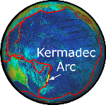
The Kermadec Arc is an active volcanic island arc stretching north-northeast from New Zealand's North Island towards Tonga. While only a few volcanoes in the arc are tall enough to form islands, it also includes about 30 submarine volcanoes. The EOI program has explored many of the submarine volcanoes of the Kermadec Arc with our New Zealand and other international colleagues. The two most recent EOI expeditions to the Kermadec arc were in 2005 and 2007.
 Submarine Ring of Fire 2007 Expedition*:
The New Zealand American Submarine Ring of Fire 2007 (NZASRoF'07) expedition focused on Brothers submarine volcano, a site of vigorous geothermal activity north of New Zealand along the Kermadec Arc. A state-of-the-art autonomous underwater vehicle (ABE) was used to explore Brothers Volcano in great detail, probably the most comprehensive exploration of this type of submarine volcano to date. In addition, some newly mapped deep rifts southwest of Brothers volcano were explored. The research vessel R/V Sonne carried a team of 26 scientists and engineers from New Zealand, Germany, and the U.S. to conduct these explorations.
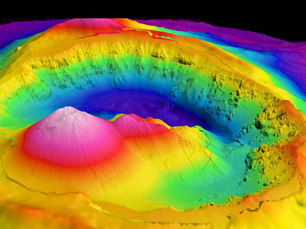 One of the outstanding successes of the expedition was a high-resolution map of the caldera of Brothers Volcano, produced by Dana Yoerger, the team leader of the autonomous benthic explorer (ABE) group. The new data allows us to be the first to “see” a submarine volcanic caldera as it really "is." An 3D image of the new bathymetry shows two cones: a large smooth-sided cone with its small crater that is the site of most of the recent volcanic activity, and a smaller cone that is partially eroded but still has intense hydrothermal activity at its summit. Beyond those the rugged topography of the wall of the caldera is apparent, created by the erosion of the steep slopes formed during previous eruptions. The comprehensive, co-located topographic, magnetic, and water-column mapping of Brothers Volcano is a new tool for exploring this type submarine volcano, and the new data allows us to see it in greater detail than ever before.
More information is available on the 2007 Cruise website, the expedition photo and video log, and in the 2007 Cruise Report (pdf)
* Funded in part by NOAA's Ocean Exploration
and Research Program
Submarine Ring of Fire 2005 Expedition*:
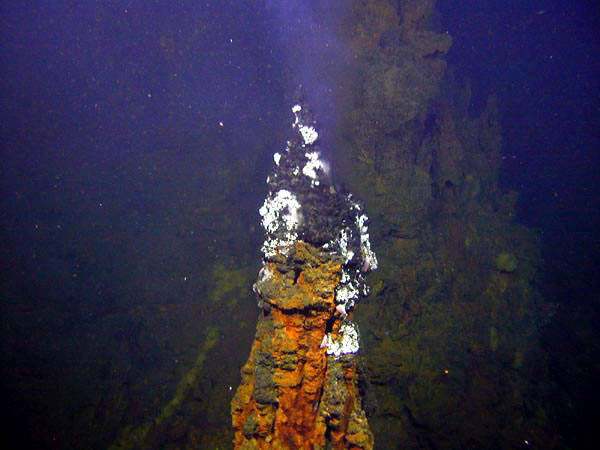 The New Zealand American Submarine Ring of Fire 2005 (NZASRoF'05) Expedition explored active submarine volcanoes in the Kermadec Arc, located north of New Zealand, with a pair of manned submersibles. This is a subduction zone where tectonic plates converge and a chain of restless volcanoes is formed along the boundary. The dive sites chosen were at volcanoes that showed evidence of having vigorous seafloor hot springs. This evidence comes from previous New Zealand / American expeditions to the area that mapped the seafloor and surveyed the ocean above each volcano for signs of hydrothermal plumes. Seafloor hot springs are dynamic environments where heat and chemicals from inside volcanoes are vented into the ocean and support unique biological communities. Most of the dive sites had never been visited before and so the potential for exciting discoveries was high.
The NZASRoF-o5 cruise track between Pago Pago, American Samoa and Tauranga, New Zealand transited more than 2900 kilometers during the first leg, stopping at 5 volcanoes (Monowai caldera, Macauley, Giggenbach, "W", and Rumble V) for 11 Pisces V submersible dives, 2 RCV-150 remotely operated vehicle deployments, and 3 CTD vertical casts. The second leg transited over 1350 kilometers between Tauranga, New Zealand and Brothers Volcano, stopping at 4 volcanoes (Clark, Rumble V, Healy and Brothers) for 6 Pisces V dives, 2 CTD tows and 1 vertical cast. Seven moorings were also recovered at Brothers (requiring 1.5 operational days). A single potential dive day was lost to weather during the first leg and 7 days were lost during the second leg. No dives or over-the-side operations were lost to equipment malfunctions. Seventeen interdisciplinary (geology + chemistry + macro-biology + micro-biology) dives were completed, compared to 20 planned dives (85%). All but one of the targeted volcanoes were visited and an extensive suite of samples (more than 200 fluid, rock, mineral and biology samples) was collected. Monowai cone was in a period of active volcanism, therefore we determined it was not safe to visit that dive site. The HURL group and the KoK crew worked very hard to prepare for this expedition and to ensure that the science teams got the maximum possible return from the dive programs.
More information is available on the 2005 Cruise website, the expedition
photo and video log, and in the 2005 Cruise Report (pdf)
* Funded in part by NOAA's Ocean Exploration and Research Program