The
PMEL MAPR:
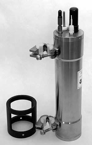
Description of the PMEL MAPR:The PMEL
MAPR was designed to be an inexpensive, lightweight yet rugged, simple
to use self-contained instrument for recording temperature, pressure,
and optical data during a wide variety of seagoing operations. There are
many cruises where geological or geophysical explorations and experiments
are conducted at midocean ridges.
researchers, and without the need for additional dedicated technicians, could be expanded worldwide. The adaptable design of MAPRs allow them to be easily attached to many types of wires or towed instrument packages. Their small size makes them easy to handle and less likely to interfere with other instruments or wire configurations. Supporting software has been developed to provides a point-and-click user interface for instrument configuration and data recovery that assures MAPRs are reliable and simple to use. Since their introduction in 1996 [Baker and Milburn, 1997; Scheirer et al., 1998], PMEL MAPRs have been successfully deployed by PMEL and non-PMEL researchers at many locations not previously sampled for hydrothermal plumes. Specifications for constructing the MAPR pressure case and internal hardware, and schematic drawings for the MAPR circuit board and sensor board, are available in the accompanying engineering drawings. (pdf files) The map (above-left)
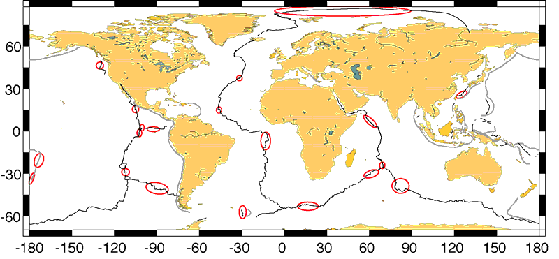
shows the path of the midocean ridge system through Earth’s ocean
basins. Red ellipses indicate locations where MAPRs have been used by
a variety of investigators to study the distribution of hydrothermal plumes.
As of 2006, MAPRs have been used in every ocean on more than 40 cruises
on research vessels from the USA, New Zealand, UK, Germany, France, Japan,
and China.
References: Bach, W., N.R. Banerjee, H.J.B. Dick, and E.T. Baker (2002): Discovery of ancient and active hydrothermal systems along the ultra-slow spreading Southwest Indian Ridge 10–16°E. Geochem. Geophys. Geosyst., doi: 10.1029/2001GC000279. Baker, E.T., M.-H. Cormier, C.H. Langmuir, and K. Zavala (2001): Hydrothermal plumes along segments of contrasting magmatic influence, 15°20'–18°30'N, East Pacific Rise: Influence of axial faulting. Geochem. Geophys. Geosyst., 2, paper number 2000GC000165, September 24, 2001. Baker, E.T., H.N. Edmonds, P.J. Michael, W. Bach, H.J.B. Dick, J.E. Snow, S.L. Walker, N.R. Banerjee, and C.H. Langmuir (2004): Hydrothermal venting in magma deserts: The ultraslow-spreading Gakkel and South West Indian Ridges. Geochem. Geophys. Geosyst., 5(8), Q08002, doi: 10.1029/2004GC000712. Baker, E.T., G.J. Massoth, K. Nakamura, R.W. Embley, C.E.J. de Ronde, and R.J. Arculus (2005): Hydrothermal activity on near-arc sections of back-arc ridges: Results from the Mariana Trough and Lau Basin. Geochem. Geophys. Geosyst., 6(9), Q09001, doi: 10.1029/2005GC000948. Baker, E.T., and H.B. Milburn (1997): MAPR: A new instrument for hydrothermal plume mapping. RIDGE Events, 8(1), January 1997, 23–25. Baker, E.T., J.A. Resing, S.L. Walker, F. Martinez, B. Taylor, and K.-I. Nakamura (2006): Abundant hydrothermal venting along melt-rich and melt-free ridge segments in the Lau back-arc basin. Geophys. Res. Lett. [In press]. Devey, C.W., K.S. Lackschewitz, and E. Baker (2005): Hydrothermal and volcanic activity found on the southern Mid-Atlantic Ridge. Eos, Trans. Am. Geophys. Union, 86(22), 209, 212. Edmonds, H.N., P.J. Michael, E.T. Baker, D.P. Connelly, J.E. Snow, C.H. Langmuir, H.J.B. Dick, R. Mühe, D.W. German, and D.W. Graham (2003): Discovery of abundant hydrothermal venting on the ultraslow-spreading Gakkel ridge in the Arctic Ocean. Nature, 421, 252–256. German, C.R., E.T. Baker, C. Mevel, K. Tamaki, and FUJI Scientific Team (1998): Hydrothermal activity along the southwest Indian Ridge. Nature, 395(6701), 490–493. German, C.R., R.A. Livermore, E.T. Baker, N.I. Bruguier, D.P. Connelly, A.P. Cunningham, P. Morris, I.P. Rouse, P.J. Statham, and P.A. Tyler (2001): Hydrothermal plumes above the East Scotia Ridge: An isolated high-latitude back-arc spreading. Earth Planet. Sci. Lett., 184(1), 241–250. Johnson, K.T.M., D.W. Graham, K.H. Rubin, K. Nicolaysen, D.S. Scheirer, D.W. Forsyth, E.T. Baker, and L.M. Douglas-Priebe (2000): Boomerang Seamount: The active expression of the Amsterdam–St. Paul hotspot, Southeast Indian Ridge. Earth Planet. Sci. Lett., 183, 245–259. Martinez, F., B. Taylor, E.T. Baker, J.A. Resing, and S.L. Walker (2006): Opposing trends in crustal thickness and spreading rate along the back-arc Eastern Lau Spreading Center: Controls on ridge morphology, faulting, and hydrothermal activity. Earth Planet. Sci. Lett. [In press]. Scheirer, D.S., E.T. Baker, and K.T.M. Johnson (1998): Detection of hydrothermal plumes along the southeast Indian Ridge near the Amsterdam-St. Paul Plateau. Geophys. Res. Lett., 25(1), 97–100. Staudigel, H., S. Hart, A. Pile, B. Bailey, E. Baker, S. Brooke, D.P. Connelly, L. Haucke, C. German, I. Hudson, D. Jones, A. Koppers, J. Konter, R. Lee, T. Pietsch, B. Tebo, A. Templeton, R. Zierenberg, and C. Young (2006): Vailulu'u Seamount, Samoa: Life and death on an active submarine volcano. Proc. Nat. Acad. Sci. [In press]. Walker, S.L., E.T.
Baker, G.J. Massoth, and R.N. Hey (2004): Short-term
variations in the distribution of hydrothermal plumes along a superfast
spreading center, East Pacific Rise, 27°30'-32°20'S . Geochem.
Geophys. Geosyst., 5, Q12005, doi: 10.1029/2004GC000789. |