P18
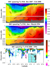
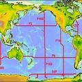
A hydrographic survey (CLIVAR/Carbon P18) was carried out on the NOAA Ship Ronald H. Brown from December 2007 through February 2008 in the eastern Pacific. Most of the survey work was a repeat of a 1994 occupation of a meridional section nominally along 110 - 103°W (WOCE P18). Two stations along a 1992 section along 67°S west of 103°W (WOCE S4P) were also taken towards the end of the cruise. Operations included CTD/LADCP/Rosette casts and radiometer casts. Underway data collected included upper-ocean currents from the shipboard ADCP, surface oceanographic and meteorological parameters from the ship's underway systems, and bathymetry data. Ancillary operations included surface drifter deployments, Argo float deployments, and XBT drops. NDBC TAO buoy servicing was also performed during the first leg of the cruise.
After an 8-day delay, NOAA Ship Ronald H. Brown departed San Diego, CA on 15 December 2007 at 0215 UTC. The ship anchored off Easter Island, Chile from 18-21 January 2008 for a personnel change and short break between leg 1 and leg 2. CLIVAR/Carbon P18 ended in Punta Arenas, Chile on 23 February 2008.
A total of 174 stations and 7 TAO Buoy sites were occupied during P18. 179 CTD/LADCP/Rosette casts (including 2 Test casts, 2 TAO calibration casts and 2 casts at station 98: the first to end leg 1 and the second to start leg 2) plus 54 radiometer casts were made. 24 ARGO floats were deployed, 17 SVP drifters were deployed, and approximately 82 XBTs were dropped. CTD data, LADCP data and water samples (up to 36 depths) were collected on most Rosette casts, in most cases to within 10-20 meters of the bottom.
Salinity, dissolved oxygen and nutrient samples were analyzed for up to 36 water samples from each cast of the principal CTD/LADCP/Rosette program. Water samples were also measured for CFCs, pCO2, Total CO2 (DIC), Total Alkalinity, pH, CDOM and Chlorophyll a. Additional samples were collected for 3He, Tritium, 13C/14C, 32Si, Millero Density, ONAR, DOC, DON, POC, and CDOM2C/CDOM3C.
Carbon Data
CTD and other hydrographic data
WOCE section designation: P18
Chief Scientists leg 1: Dr. John L. Bullister and Dr. Dong-Ha Min
Chief Scientists leg 2: Dr. Gregory C. Johnson and Dr. Alejandro Orsi
Dates: 15 DEC 2007 to 18 JAN 2008 Leg 1, 21 JAN 2008 to 23 FEB 2008 Leg 2
Ship: RONALD H. BROWN
Ports of call: San Diego, CA - Easter Island, Chile Leg 1, Easter Island - Punta Arenas, Chile Leg 2
Stations: 174
Geographic boundaries: 24° 27.56" N to 69° 26.63" S by 112° 54.39" W to 102° 32.47" W


