Related Stories

A MAPCO2 system is deployed on the Ala Wai mooring (21.28°N, 157.85°W) as part of the Hawaii Ocean Carbon Network. ...


The PMEL carbon group is developing a network of carbon dioxide systems on coastal moorings. ...

The PMEL carbon group is developing a network of carbon dioxide systems on coastal moorings. ...

The PMEL carbon group is developing a network of carbon dioxide systems on deep water moorings. ...
Kaneohe
Kaneohe Offshore Observatory within the Hawaii Ocean Carbon Network (21.48°N, 157.78°W)
Kaneohe Bay, located on the eastern side of Oahu, Hawaii, is a complex estuarine system with a large barrier coral reef, numerous patch reefs, fringing reefs, and several riverine inputs. The Kaneohe Bay system consists of an inner bay that includes waters landward of the barrier reef and an outer bay that includes water over the barrier reef. The inner bay is host to the CRIMP2 buoy (deployed June 2008) at the landward edge of the barrier reef and also hosted the original CRIMP buoy which was deployed in the southern sector of the bay between December 2005 and May 2008, after which it was moved to the current CRIMP2 location. Water generally flows across the barrier reef from the open ocean into the central bay and return flows occur primarily through two channels: a deep shipping channel in the northern bay and the Sampan Channel about one kilometer south of the CRIMP2 location in the central bay. Northeasterly (Trade) winds that prevail during 80% of the year generate waves at the seaward edge of the barrier reef and drive flow across the reef. Strong winter swells from the N and NE also contribute to wave driven flow across the reef. The tides in Kaneohe Bay, which are mixed semi-diurnal with a mean tidal amplitude of approximately 68 cm day-1, also play in role in water flow across the reef.
The Kaneohe buoy was deployed in 2011 in approximately 60 ft of water on the open ocean side of the barrier reef. This location was selected as a complement to the CRIMP2 site in order to allow evaluation of the changes that take place in the chemistry of seawater as it travels across the barrier reef as a result of calcification and primary productivity and their respective reverse processes (carbonate mineral dissolution and respiration). Travel time across the reef varies from a few hours under strong wave driven flow to more than twelve hours under calm conditions.
This new buoy was deployed as part of a collaboration between the PMEL carbon group and collaborators from the University of Hawaii Department of Oceanography to better understand the CO2 dynamics of Kaneohe Bay. The lab members of University of Hawaii oceanographer Christopher Sabine are studying the temporal variability in air-sea fluxes and examining the physical and bio-chemical mechanisms controlling CO2 fluxes on Hawaiian coral reefs. The climate and ecosystem monitoring at this location is supported by NOAA’s Coral Reef Conservation Program and Ocean Acidification Program.
On September 29, 2011, a surface seawater pH sensor was added to the Kaneohe mooring. By measuring pH in addition to pCO2, we are able to more accurately and precisely study the changes associated with ocean acidification. All seawater pH observations are shown in the second figure below.
For more information about the mooring and meteorological sensors please visit the PacIOOS Water Quality Buoys site.
Data availability: archived at NCEI.
Plots of surface water and atmospheric CO2 and surface water pH (click+drag to zoom):
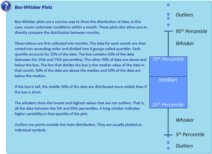
Monthly climatology of surface seawater aragonite saturation state (Ω) and pH:
Interactive box plots below are observations binned by month as described in Sutton et al., 2016. Pie charts represent % of observations within each month that fall below the adjustable line. This adjustable line is meant to provide a tool for assessing potential biological thresholds. For example, setting the line to Ωaragonite of ~2.0 would assess monthly exposure of Pacific oyster larvae to sub-lethal chronic effects in regions where these larvae occur naturally or in hatcheries (see studies here and here).