Related Stories

The PMEL carbon group is developing a network of carbon dioxide systems on coastal moorings. ...

The PMEL carbon group is developing a network of carbon dioxide systems on coastal moorings. ...

The PMEL carbon group is developing a network of carbon dioxide systems on deep water moorings. ...

The coastal LA buoy is located in 20 m water depth on the Louisiana continental shelf. ...
Related Content


Coastal MS
Coastal Mississippi Buoy (30°N, 88.6°W)
The Central Gulf of Mexico Ocean Observing System (CenGOOS) station CenGOOS-01 was initially established in December of 2004 with funding by the Office of Naval Research, with subsequent funding through NOAA. The buoy has survived two hurricanes (Katrina in 2005 and Gustav in 2008), and although damaged, was repaired and redeployed each time. The 3 m discus buoy USM3m02, with the NOAA MAPCO2 instrument package, was deployed at station CenGOOS-01 on April 30, 2009 from the R/V Tommy Munro.
On March 18, 2011, a surface seawater pH sensor was added to the Coastal Mississippi Mooring mooring. By measuring pH in addition to pCO2, we are able to more accurately and precisely study the changes associated with ocean acidification. All seawater pH observations are shown in the second figure below. This project is supported by NOAA's Ocean Acidification Program. In July 2017 this site was discontinued and the buoy platform and sensors were moved to nearby coastal LA.
Data availability: archived at NCEI.
Plots of surface water and atmospheric CO2 and surface water pH: (click+drag to zoom)
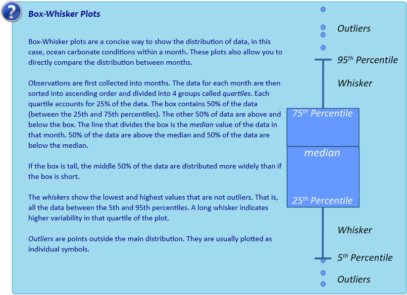
Monthly climatology of surface seawater aragonite saturation state (Ω) and pH:
Interactive box plots below are observations binned by month as described in Sutton et al., 2016. Pie charts represent % of observations within each month that fall below the adjustable line. This adjustable line is meant to provide a tool for assessing potential biological thresholds. For example, setting the line to Ωaragonite of ~2.0 would assess monthly exposure of Pacific oyster larvae to sub-lethal chronic effects in regions where these larvae occur naturally or in hatcheries (see studies here and here).