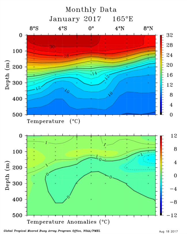
All of the fields displayed as latitude-depth sections are fields of gridded monthly or 5-day means. Gridding was done by 1) removing the Kessler (1994) CTD/XBT Objective Analysis from the temperatures after bilinearly interpolating it to a 1° by 1° latitude-longitude grid, and in the case of 5-day means, also interpolating the climatology to the data times. A special exception to this is along 95°W where we use the Bureau of Meteorology Research Center (BMRC) temperature climatology rather than the Kessler climatology, because we have data at 12°N during the EPIC program, and the Kessler domain extends only to 10°N. BMRC is used at all latitudes along 95°W so that we have coherent anomalies extending to 12°N. This introduces a small inconsistency between anomalies shown in in the Depth-Longitude and Latitude-Depth section plots at 95°W. The BMRC climatology was provided to us courtesy of Dr. Neville Smith. 2) linearly interpolating the monthly or 5-day data anomalies at the nominal TAO/TRITON array coordinates to these standard depths:
0, 10, 20, 30, 40, 50, 60, 70, 80, 90, 100, 110, 120, 130, 140, 160, 180, 200, 225, 250, 275, 300, 400, 500 (m)
3) linearly interpolating in latitude to 1° spacing, 4) 5° triangle filtering in latitude, 5) distance-weighted binomial (1/4-1/2-1/4) filtering in depth, and 6) adding these gridded and smoothed anomalies to the Kessler objective analysis to produce the mean latitude-depth field.
The locations of data input to the gridding routine are indicated by the little x's on the plots.
For more information on the Kessler (1994) Objective Analysis of Historical CTD and XBT temperatures, see the Climatology Background page, and to see plots of the Kessler Analysis, see the Climatology page under the "Latitude-Depth Sections of Temperature".