The Bering Sea (Fig. 30.1) is a northern extension of the North Pacific Ocean, and is the world's third-largest semi-enclosed sea. A continental shelf underlies about one-half of the Bering Sea, consisting of a broad (>500 km) eastern portion between the Alaska Peninsula and Cape Navarin, and a narrower (<100 km) western portion between Cape Navarin and Kamchatka Strait. Mean northward transport (~0.8 × 10![]() m
m![]() s
s![]() ) through Bering Strait is driven by an ~0.5 m sea level difference between the Bering Sea and Arctic Ocean (Coachman, 1993). This transport provides the only connection and exchange of water between the Pacific and Atlantic Oceans in the northern hemisphere. This northward flow requires transport onto the shelf of nutrient-rich slope waters from the Bering Slope Current, the eastern boundary current of the cyclonic gyre that dominates circulation in the Bering Sea gyre (Stabeno et al., 1999). Over the northern shelf, nutrient-rich water upwells due to shoaling topography, thereby stimulating primary production (Nihoul et al., 1993). Ice forms predominantly in the polynyas over the northern shelf. The cold, saline water formed from brine rejection sinks and flows northward through Bering Strait. Globally, this water plays a role in maintaining the Arctic Ocean halocline and hence ventilation of the deep waters (Aagaard et al., 1985).
) through Bering Strait is driven by an ~0.5 m sea level difference between the Bering Sea and Arctic Ocean (Coachman, 1993). This transport provides the only connection and exchange of water between the Pacific and Atlantic Oceans in the northern hemisphere. This northward flow requires transport onto the shelf of nutrient-rich slope waters from the Bering Slope Current, the eastern boundary current of the cyclonic gyre that dominates circulation in the Bering Sea gyre (Stabeno et al., 1999). Over the northern shelf, nutrient-rich water upwells due to shoaling topography, thereby stimulating primary production (Nihoul et al., 1993). Ice forms predominantly in the polynyas over the northern shelf. The cold, saline water formed from brine rejection sinks and flows northward through Bering Strait. Globally, this water plays a role in maintaining the Arctic Ocean halocline and hence ventilation of the deep waters (Aagaard et al., 1985).
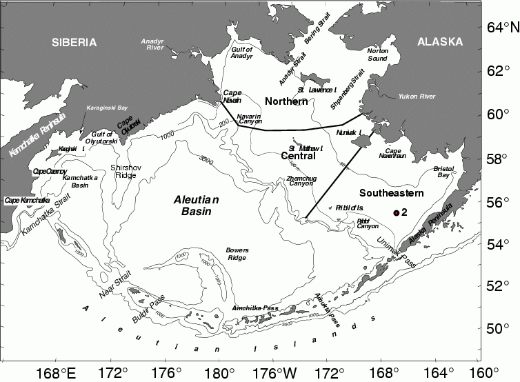
Figure 30.1: Geography and place names of the Bering Sea. The location of the M2 is indicated. Depth contours are in meters. (From Schumacher and Stabeno, 1998 or Stabeno et al., 1999.)
The eastern Bering Sea is home to a rich variety of biota, including the world's most extensive eelgrass beds; at least 450 species of fish, crustaceans, and mollusks; 50 species of seabirds; and 25 species of marine mammals. It has been classified as its own bio-geographic province (Longhurst, 1998) and as a Class II, moderately high (150–300 gC/m![]() /yr) productivity, ecosystem based on satellite remote sensing estimates (www.edc.uri.edu/lme/text/east-bering-sea.htm), although primary production estimates for sub-regions are much higher (e.g., Springer and McRoy, 1993). The abundant fish and wildlife of the Bering Sea have supported the lives and livelihoods of Asians and North Americans since prehistoric times. For the 65,000 Alaskan natives living on the shores of the eastern Bering Sea (NRC, 1996), subsistence is not just a means of providing food; it is the wellspring of spiritual and cultural traditions. Presently (2002), the U.S. Bering Sea fishery provides about 40% of the U.S. and about 5% of the world harvest of fish and shellfish with walleye pollock (Theragra chalcogramma) comprising much of the fish landings; the tanner crab (Chionoecetes bairdi) fishery currently is the largest crustacean fishery (by weight) in the U.S. Bristol Bay and supports the world's largest sockeye salmon (Onchorhynchus nerka) fishery. In addition to supporting a large portion of the nation's fishery production, the Bering Sea supports ~80% of the U.S. nesting seabird population, comprising approximately 36 million birds. Furthermore, many endemic species such as red-legged kittiwakes (Rissa brevirostris) and whiskered auklets (Aethia pygmaea) are found in the Bering Sea and further highlight the significance of this region. Prior to the 1960s, there were much larger populations of northern fur seals (Callorhinus ursinus), Steller sea lions (Eumetopias jubatas), whales and birds. The U.S. government has listed the Steller sea lion and spectacled eider (Somateria fischeri) as endangered species, sea otters (Enhydra lutris) as threatened, and there are declines of some salmon populations that have adversely affected commercial and subsistence harvest. This region's wetlands, coastlines and islands provide globally significant habitats for many additional wildlife species, and its natural history holds answers to important questions about world history, including the introduction of hominids to North America.
/yr) productivity, ecosystem based on satellite remote sensing estimates (www.edc.uri.edu/lme/text/east-bering-sea.htm), although primary production estimates for sub-regions are much higher (e.g., Springer and McRoy, 1993). The abundant fish and wildlife of the Bering Sea have supported the lives and livelihoods of Asians and North Americans since prehistoric times. For the 65,000 Alaskan natives living on the shores of the eastern Bering Sea (NRC, 1996), subsistence is not just a means of providing food; it is the wellspring of spiritual and cultural traditions. Presently (2002), the U.S. Bering Sea fishery provides about 40% of the U.S. and about 5% of the world harvest of fish and shellfish with walleye pollock (Theragra chalcogramma) comprising much of the fish landings; the tanner crab (Chionoecetes bairdi) fishery currently is the largest crustacean fishery (by weight) in the U.S. Bristol Bay and supports the world's largest sockeye salmon (Onchorhynchus nerka) fishery. In addition to supporting a large portion of the nation's fishery production, the Bering Sea supports ~80% of the U.S. nesting seabird population, comprising approximately 36 million birds. Furthermore, many endemic species such as red-legged kittiwakes (Rissa brevirostris) and whiskered auklets (Aethia pygmaea) are found in the Bering Sea and further highlight the significance of this region. Prior to the 1960s, there were much larger populations of northern fur seals (Callorhinus ursinus), Steller sea lions (Eumetopias jubatas), whales and birds. The U.S. government has listed the Steller sea lion and spectacled eider (Somateria fischeri) as endangered species, sea otters (Enhydra lutris) as threatened, and there are declines of some salmon populations that have adversely affected commercial and subsistence harvest. This region's wetlands, coastlines and islands provide globally significant habitats for many additional wildlife species, and its natural history holds answers to important questions about world history, including the introduction of hominids to North America.
The current state of this ecosystem is a product of its history that includes substantial human and natural impacts. Western knowledge of the Bering Sea's rich ecosystem began with Vitus Bering's voyage in 1741 (Ford, 1966). Over the next two centuries, commercial exploitation brought the Steller sea cow to extinction, and the sea otter, fur seal, walrus and bowhead whale nearly to extinction (Fay, 1981). In the early 1950s, the "commercial fishing period" began and that, together with the removal of marine mammals (until the early 1970s), had a marked impact on the composition of the ecosystem (NRC, 1996). These factors form the basis of the Trophic Cascade Hypothesis (Merrick, 1997; NRC, 1996). As the large populations of mammals (particularly whales) and fish were removed, there was an increased amount of food (zooplankton and small fish) for other vertebrate predators. There is little doubt that the over-exploitation and reductions of these populations, together with a regime shift in the physical environment, led to a switch in the late 1960s and early 1970s to a system dominated by pollock, which has persisted since then (NRC, 1996).
Much of the early oceanographic research was conducted to address questions relating to the international fishery (Takenouti and Ohtani, 1974; Arsenev, 1967; Hood and Kelley, 1974; and Favorite et al., 1976). In the early 1950s, Hokkaido University began annual training cruises to the Bering Sea and established what has become one of the longest physical and biological time series available in the region (e.g., Sugimoto and Tadokoro, 1997). Between the mid-1970s and late 1980s, the focus changed to resource assessment on the eastern shelf as part of the Outer Continental Shelf Environmental Assessment Program (OCSEAP; Hood and Calder, 1981). Annual groundfish and crab assessment continues to this day by NOAA/National Marine Fisheries Service. OCSEAP was followed by ecosystem research over the southeastern (PROBES; Processes and Resources of the Bering Sea: Hood, 1999) and northern shelf (ISHTAR; Inner Shelf Transfer and Recycling in the Bering and Chukchi Seas: McRoy, 1999), and examination of ice related phenomenon during the Bering Sea Marginal Ice Zone Experiment (MIZEX: Muench, 1983). During the 1990s, research focused again on fisheries and the influence of the physical factors on the ecosystem. Major contributions included those from the Fisheries Oceanography Coordinated Investigations program (FOCI: Schumacher and Kendall, 1995); NOAA's Coastal Ocean Programs, Bering Sea FOCI (BSFOCI: Bailey et al., 1999; Brodeur et al., 1999b; Napp et al., 2000) and the Southeast Bering Sea Carrying Capacity program (SEBSCC: Stabeno and Hunt, 2002; Macklin et al., 2002); the National Science Foundation (Polar Programs) "Study of prolonged production, trophic transfer, and processes at the Bering Sea inner front" (hereafter called Inner Front Study: Stabeno and Hunt, 2002) and a program to conduct long-term ecological research on marine ecosystems in the Arctic and Pacific Oceans (BERPAC: Tsyban, 1999). Alexander (1999) provides a review of many of the interdisciplinary studies of the Bering Sea.
Features of the Bering Sea (including solar radiation, atmospheric phenomenon, sea ice cover, and water column structure and temperature, and biological production) vary over a wide range of time scales. These include strong seasonal and annual signals and smaller, but potentially important longer-period fluctuations. Over the vast region of the eastern shelf, most of the physical phenomena also vary greatly with both latitude and longitude. The variability in physical features, together with the flux of nutrient-rich slope waters onto the eastern shelf, shapes one of the world's most productive ecosystems (Walsh et al., 1989). Observations suggest that a highly productive region also exists over the edge of the continental shelf (Springer et al., 1996). This "green belt" extends around the entire perimeter of the continental shelf and estimates of both primary and secondary production in this belt are more than 60% greater than production over the adjacent shelf waters.
In this chapter, we first present a conceptual model of the pathways by which changes in atmospheric phenomenon can influence sea ice, oceanic features and biota. While some of the pathways may be specific to the Bering Sea, much is directly applicable to other subarctic seas. We then present the salient features of the physical environment summarized from Schumacher and Stabeno (1998), updated to include more recent findings (e.g., Kachel et al., 2002; Overland et al., 1999a; Stabeno et al., 2002). Our focus here is on interdisciplinary ocean science, with a particular focus on several phenomena whose influence on biota has been established: water temperature, transport and turbulence. Following Schumacher and Stabeno (1998), we partition the continental shelf of the Bering Sea into eastern (primarily U.S. waters) and western regions, with the former further differentiated into southeastern, central and northern sub-regions. The following sections describe processes of the eastern Bering Sea shelf and those over the northern and western shelf. We conclude with a discussion of suggestions for future research.