The Bering Sea is a semi-enclosed, high-latitude sea that is bounded on the north and west by Russia, on the east by Alaska, and on the south by the Aleutian Islands (Fig. 1). It is divided almost equally between a deep basin (maximum depth 3,500 m) and the continental shelves (<200 m). The broad (>500 km) shelf in the east contrasts with the narrow (<100 km) shelf in the west. Seasonal extremes occur in solar radiation, meteorological forcing, and ice cover. Large interannual fluctuations exist in climate, due both to the Southern Oscillation and the Pacific-North American atmospheric pressure patterns (Niebauer 1988; Niebauer et al., chapter 2, this volume). An amplification of global warming is predicted in the Bering Sea (Bryan and Spelman 1985). Basin scale climate variability profoundly impacts both the physical and biological environment (Schumacher and Alexander, chapter 6, this volume).
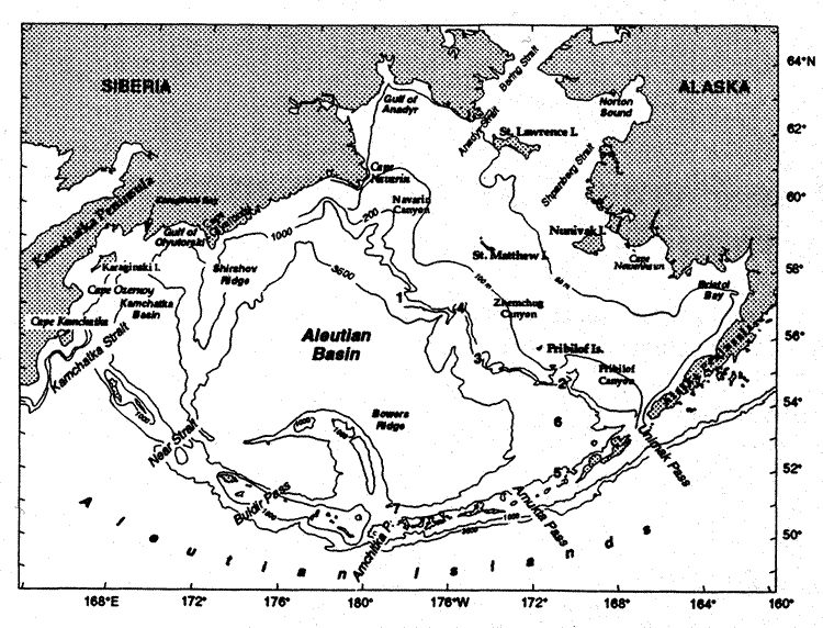
Fig. 1. Geography and place names of the Bering Sea. The location of the seven mooring sites discussed in the text are indicated by bold numerals. Depth contours are in meters.
Interactions among ocean, ice, and atmosphere dominate the physics of the Bering Sea. Large-scale weather patterns in both the tropical South Pacific (El Niño-Southern Oscillation events) and the North Pacific (Pacific-North America patterns) have strong connections to the Bering Sea, mainly via the atmosphere (Niebauer 1988, Niebauer and Day 1989, Niebauer et al., chapter 2, this volume). The mode of teleconnection appears to perturb the passage of storms (areas of low sea level atmospheric pressure with closed isobars) along the Aleutian Island chain. The migration of storms results in a statistical feature known as the Aleutian Low, one of the two main low pressure systems in the high latitude Northern Hemisphere. During summer with its long periods of daylight and high insolation, the Aleutian Low is typically weak and weather benign. During winter, a marked change occurs in atmospheric pressure fields. High sea level pressure (Siberian High) dominates Asia, while the Aleutian Low intensifies and dominates weather over the North Pacific and Bering Sea. The juxtaposition of these features results in strong, frigid winds from the northeast. The frequency and intensity of storms in the southern Bering Sea decreases from winter to summer and frequency also decreases with increasing latitude (Overland 1981, Overland and Pease 1982). In the winter, an average of three to five storms per month move eastward along the Aleutian Chain forming the primary storm track, while less than two storms per month cross the northern Bering Sea. A secondary storm track curves northward along the Asian coast. A difference in the number of storms also occurs across the broad shelf, with more activity occurring over the outer shelf (Schumacher and Kinder 1983).
Due to the presence of the Aleutian Low, the wind torque over the Bering Sea is greater in winter than in summer by an order of magnitude. A climatology of the wind forcing (Bond et al. 1994) shows that eastward and northward-propagating storm systems dominate the surface stress at short periods (<1 month), and their energy mixes the upper ocean. At longer periods (>1 month), the wind-driven (Sverdrup) transport accounts for roughly one-half of the observed transport in the Kamchatka Current. Driven by changes in the location of the Aleutian Low, interannual variations in the Sverdrup transports occur that are ~25% of the mean.
Much of the physical oceanographic research in the Bering Sea has been coupled
to fisheries research, since the combination of nutrient-rich slope waters and
high summer solar radiation create one of the world's most productive ecosystems
(Walsh
et al. 1989). Seasonal primary production often begins with a bloom on the
shelf associated with ice-edge melt; annual production varies from >200 g C/m over the southeastern shelf to >800 g C/m
north of St. Lawrence Island. Over the western shelf maximum annual production
(>400 g C/m) occurs over the continental
slope (Arzhanova
et al. 1995). These blooms often consume all available nutrients (Niebauer
et al. 1995), so subsequent production depends on nutrients being supplied
by mixing due to storms and/or advection. The blooms support strong higher trophic
level production which in turn supports vast populations of marine mammals,
birds, fish, and shellfish. During the mid-1980s, the pollock fishery was the
world's largest single species fishery, and during the mid-1990s the salmon
run along the Alaska Peninsula was the world's largest.
over the southeastern shelf to >800 g C/m
north of St. Lawrence Island. Over the western shelf maximum annual production
(>400 g C/m) occurs over the continental
slope (Arzhanova
et al. 1995). These blooms often consume all available nutrients (Niebauer
et al. 1995), so subsequent production depends on nutrients being supplied
by mixing due to storms and/or advection. The blooms support strong higher trophic
level production which in turn supports vast populations of marine mammals,
birds, fish, and shellfish. During the mid-1980s, the pollock fishery was the
world's largest single species fishery, and during the mid-1990s the salmon
run along the Alaska Peninsula was the world's largest.
This paper both reviews and presents new data on the physical oceanography of the Bering Sea. It will focus on the basin, since a thorough review of the shelves has recently been completed (Schumacher and Stabeno 1998). Further, since this volume contains an extensive review of the water property characteristics (Luchin et al., chapter 3, this volume), the primary goal here is to review and update circulation over the basin. We begin with the known and estimated transports through each of the passes of the Aleutian Islands, followed by a discussion of the surface and deep currents of the Bering Sea basin and the flow on the Bering Sea shelves.
Return to Abstract or go to next section