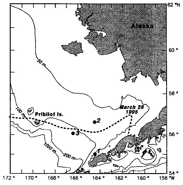
Figure 1. A map of the eastern Bering Sea continental shelf indicating the locations of the three moorings. Maximum ice extent during 1995 is shown by a dashed line. Depth contours are in meters.
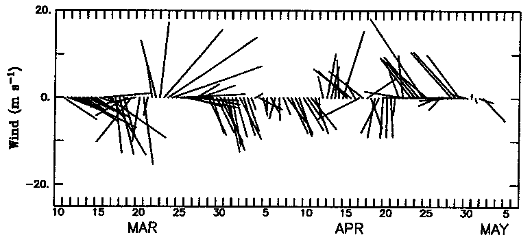
Figure 2. Wind velocity derived from atmospheric pressure and interpolated to a point midway between moorings 1 and 2. North is along the y-axis.
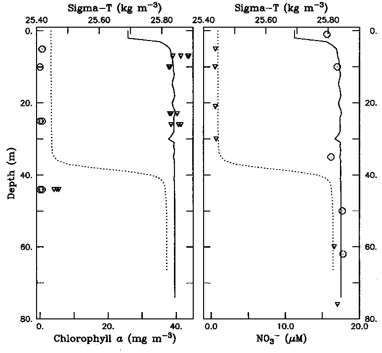
Figure 3. At mooring site 2, (a) concentration of chlorophyll-a as measured from CTD casts taken on deployment (circle) and recovery (triangle) and (b) concentration of dissolved nitrate upon deployment (circle) and recovery (triangle). The density structure upon deployment (dashed) and recovery (solid) is also shown in each panel.
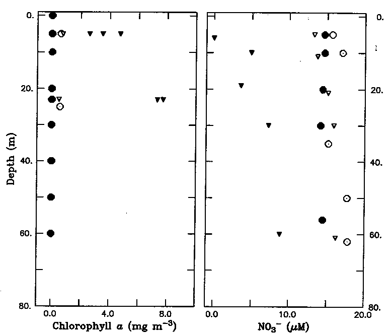
Figure 4. At mooring site 1, (a) concentration of chlorophyll-a as measured from CTD casts on March 14 (open circle), April 23 (closed circle), May 5 (open triangle), and May 17 (closed triangle); (b) concentration of dissolved nitrate for same days as in (a).
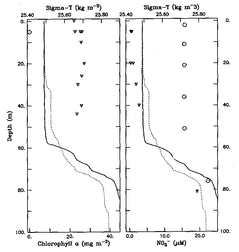
Figure 5. As in Figure 3, except for mooring site 3.
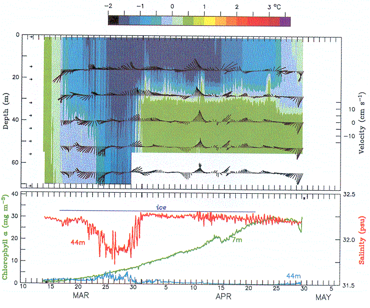
Figure 6. (a) Temperature measured at mooring 2. The vertical location of each instrument is indicated by an arrow along the depth axis. Plotted over the contours of temperature at the appropriate depths are 6 hourly low-pass filtered current vectors (upward indicates northward flow). (b) Chlorophyll-a as determined by an A-3 (7 m) and as inferred from a fluorometer (44 m). The estimated period when ice covered the mooring is indicated by the blue line. Salinity at 44 m (the shallowest SEACAT that gave data) is shown in red.
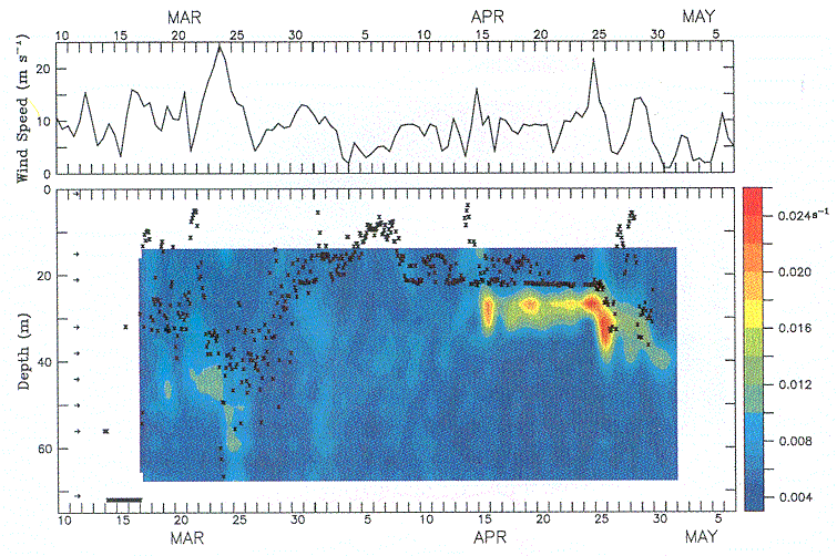
Figure 7. (a) Wind speed derived from atmospheric pressure. (b) Daily averaged shear (s ) determined from hourly ADCP records at mooring 2.
Velocity was measured in 4-m bins. The 2-hourly depth of the mixed layer (defined by differing
by 0.1° from the temperature at 1 m) at 6-hr intervals is indicated by +.
) determined from hourly ADCP records at mooring 2.
Velocity was measured in 4-m bins. The 2-hourly depth of the mixed layer (defined by differing
by 0.1° from the temperature at 1 m) at 6-hr intervals is indicated by +.
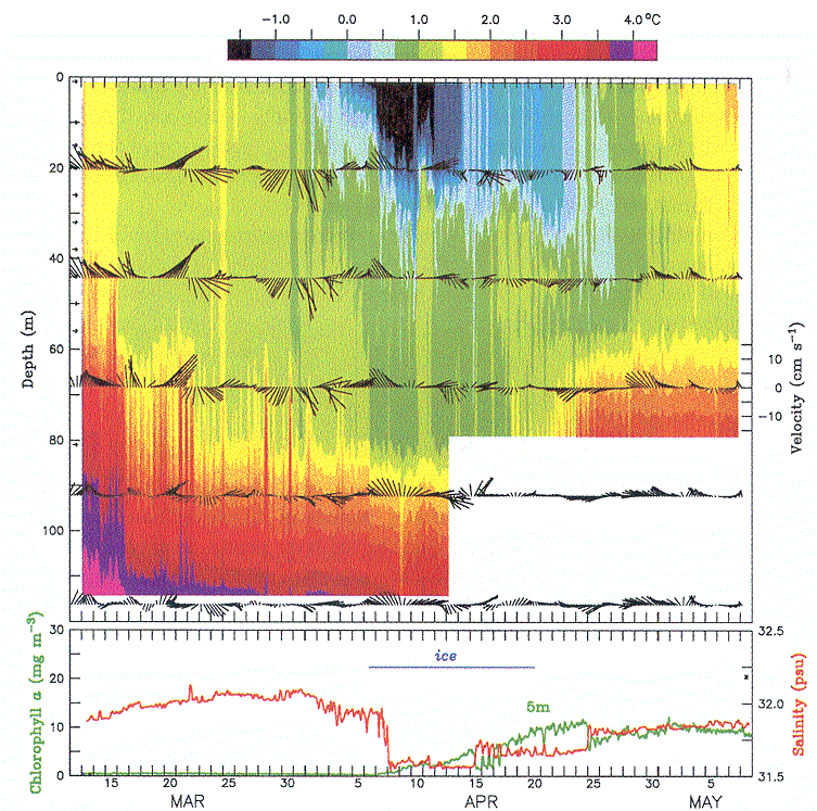
Figure 8. (a) Temperature measured at mooring 3. The vertical locations of the measured temperatures are indicated by arrows. Plotted over the contours of temperature at the appropriate depths are 6 hourly low pass filtered current vectors. (b) chlorophyll-a as measured by an A-3 (7 m) is shown in green. The period when ice covered the mooring is indicated by the blue line. Salinity at 10 m is shown in red.
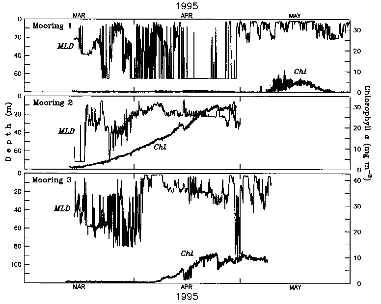
Figure 9. The 2-hourly depth of the mixed layer and hourly concentration of
chlorophyll-a estimated from A-3 for (a) mooring 1, (b) mooring 2, and (c) mooring 3.
Table 1. Mooring location, water depth, deployment period, and depths (m) of subsurface
instruments. ADCPs (with SEACAT ) were deployed
within 1 km of surface mooring. Instruments that failed and provided no data are indicated by
asterisks (*). ) were deployed
within 1 km of surface mooring. Instruments that failed and provided no data are indicated by
asterisks (*). |
|||||||||||||||
| MTR | SEACAT | Fluorometer | A-3 | ||||||||||||
| Mooring 1 | 1 | ||||||||||||||
55°04 : 164°31 : 164°31 |
15 | 10 | 5 | * | |||||||||||
| 65 m | 20 | 26 | 21 | ||||||||||||
| March 14-June 15 | 32 | 44 | |||||||||||||
| 600 KHz ADCP | 38 | 60 | |
||||||||||||
| 50 | |||||||||||||||
| Mooring 2 | 1 | ||||||||||||||
| 56°36 : 164°37 |
15 | 11 | * | 11 | * | 7 | |||||||||
| 75 m | 20 | 22 | * | 22 | * | 14 | * | ||||||||
| March 14-April 29 | 32 | 44 | 44 | ||||||||||||
| 150 KHz ADCP | 38 | 68 | |
||||||||||||
| 50 | |||||||||||||||
| 56 | |||||||||||||||
| Mooring 3 | 1 | 10 | 7 | ||||||||||||
| 56°02 : 166°23 |
15 | 26 | |||||||||||||
| 123 m | 20 | 44 | |||||||||||||
| March 13-May 8 | 32 | 80 | |||||||||||||
| 150 KHz ADCP | 38 | 118 | |
||||||||||||
| 50 | |||||||||||||||
| 56 | |||||||||||||||
Return to References or go back to Abstract