
U.S. Dept. of Commerce / NOAA / OAR / PMEL / Publications
Figure 1. The study area in the western Gulf of Alaska. The location of the moorings at Wide Bay (21-25, 28, and 29) and Cape Kekurnoi (1-3) are indicated by circles. The inset shows regional circulation. Depths are in meters.
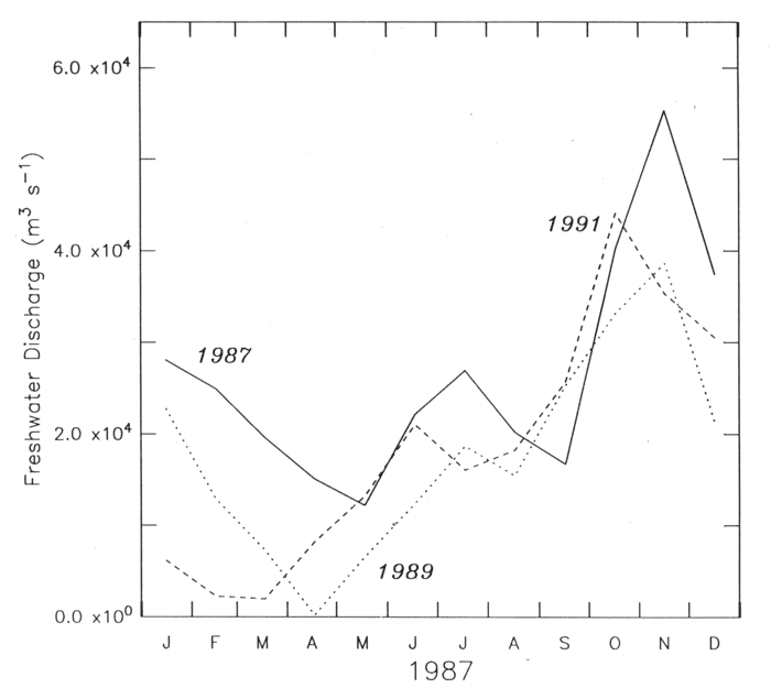
Figure 2. Time series of the monthly mean freshwater input for 1987, 1989, and 1991 (data from T. Royer, personal communication, 1994).
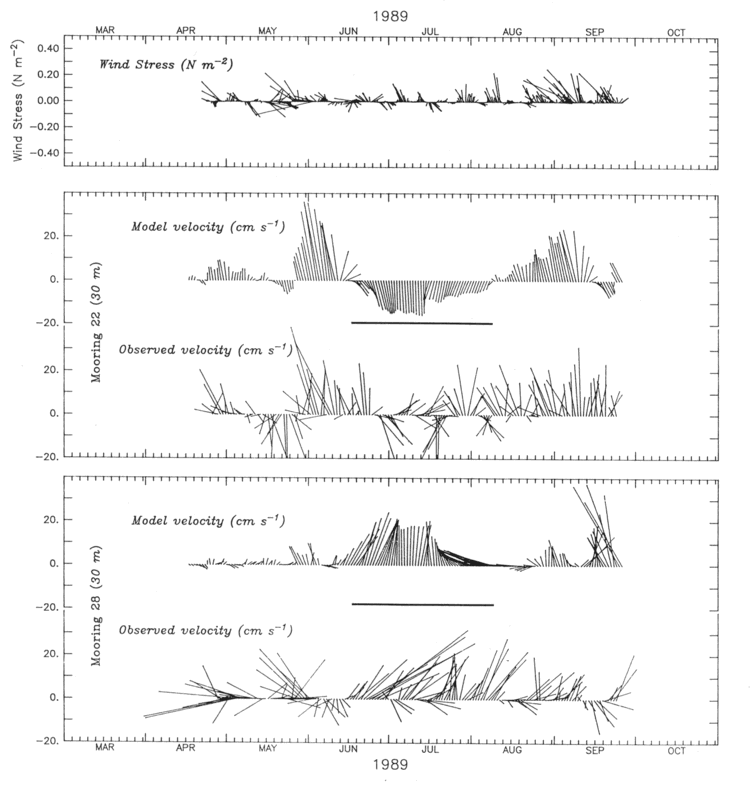
Figure 3. The wind stress at 57.5°N, 155°W and the daily velocity at selected depths from current meter measurements and the 1989 model simulation. Series were rotated to along isobath (220°T). The bold lines indicate when the large eddy discussed in the text was present in the simulation.
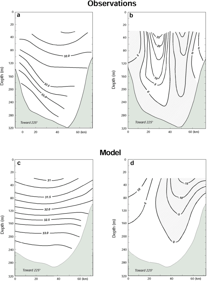
Figure 4. The (a) salinity (practical salinity units) and (b) velocity (centimeters per second) structure of an eddy observed in the sea valley near Wide Bay in 1989 (from Bograd et al. [1994]) and the (c) salinity (practical salinity units) and (d) velocity (centimeters per second) structure of an eddy near Wide Bay simulated by the model. Hatched regions indicate flow toward the northeast (up the sea valley).
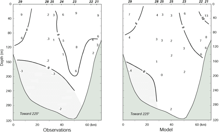
Figure 5. Cross section of mean alongshore current (centimeters per second) observed off Wide Bay for the period April 27 through June 6, 1989, from (a) current meter measurements and (b) model simulation. Hatched regions indicate flow toward the northeast (up the sea valley). Mooring locations are indicated at the top of each panel.
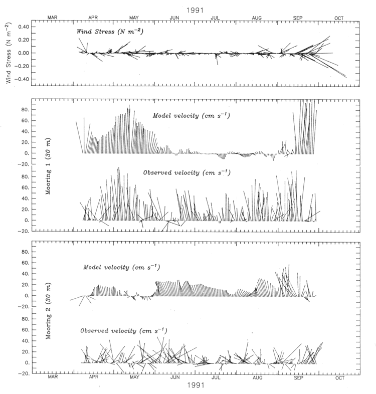
Figure 6. The wind stress at 57.5°N, 155°W and the daily velocity at selected locations from current meter measurements and the 1991 model simulation. Series were rotated to along isobath (220°T).
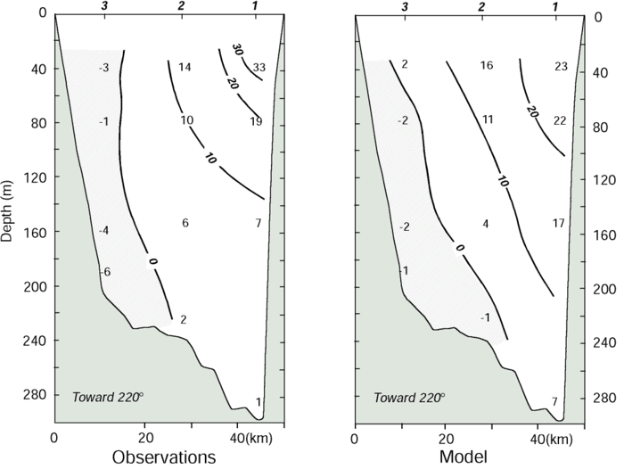
Figure 7. Cross section of the mean alongshore current (centimeters per second) observed off Cape Kekurnoi for the period April 8 through September 30, 1991, from (a) current meter measurements and (b) model simulation. Hatched regions indicate flow toward the northeast (up the sea valley). Mooring locations are indicated at the top.
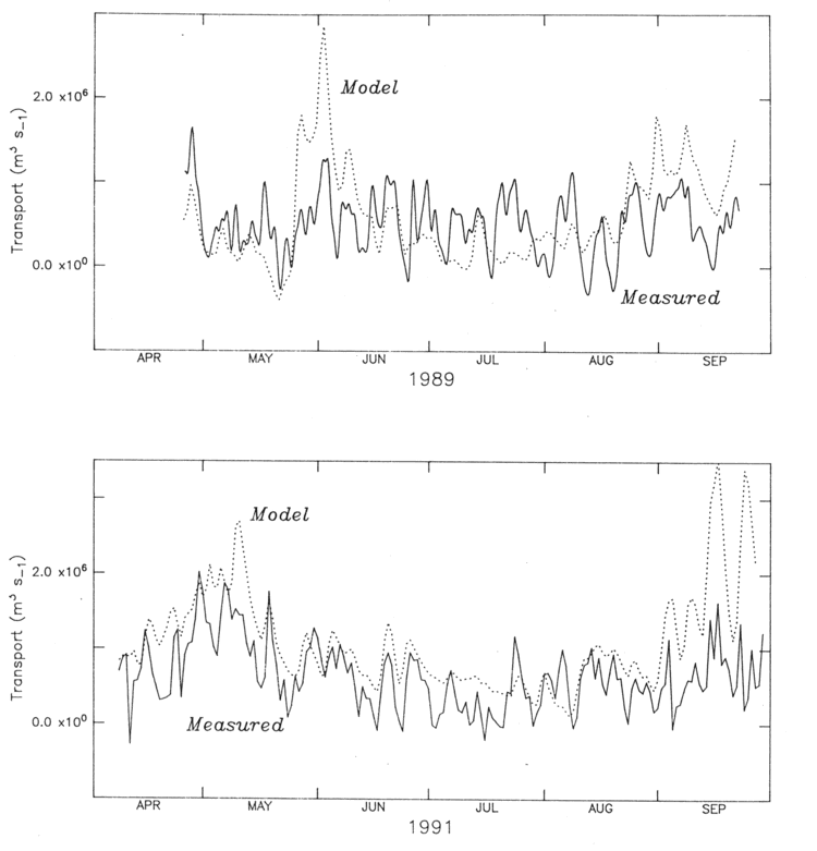
Figure 8. Time series of transport (as measured by current meters and simulated by the model) through (a) the section off Wide Bay (1989) and (b) through the section off Cape Kekurnoi (1991).
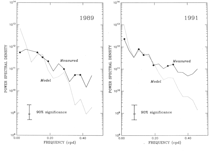
Figure 9. Spectra of the modeled and measured transport for (a) 1989 and (b) 1991. Frequencies at which the coherence between measured and modeled transport was above 0.44 (95% significance level) are indicated with solid circles.
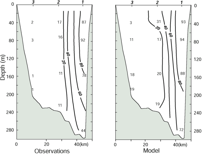
Figure 10. The horizontal structure for percent variance explained by the first empirical orthogonal function mode at each current meter location for (a) observed and (b) modeled currents during 1991.
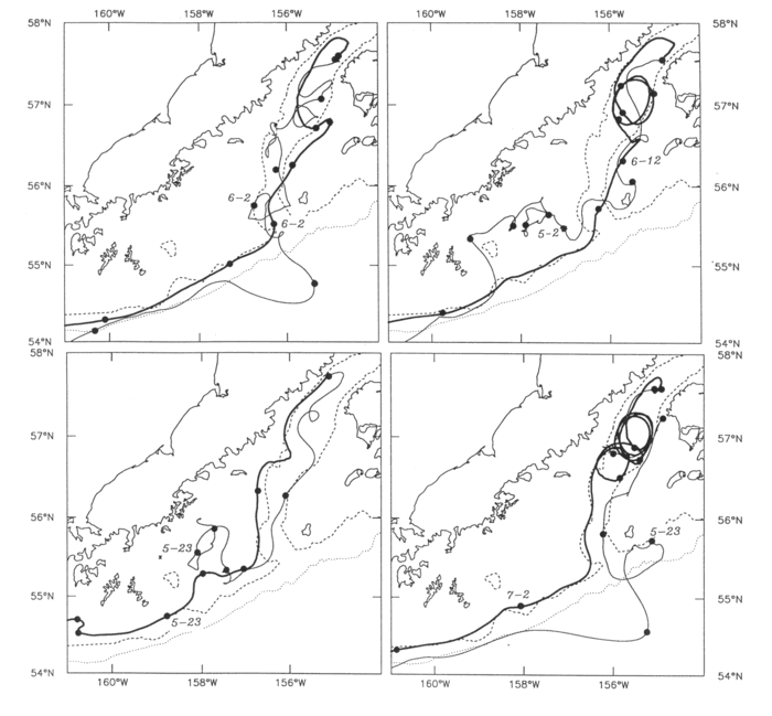
Figure 11. Trajectories of four buoys deployed in 1987 (thin solid lines) compared with buoys seeded at the same location and time into the model simulations (thick solid lines). Solid circles indicate every 10 days.
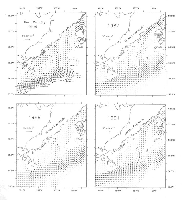
Figure 12. Maps of horizontal currents at 40 m (a) generated from the trajectories of 51 satellite-tracked drifting buoys and simulated by the model for (b) 1987, (c) 1989, and (d) 1991.
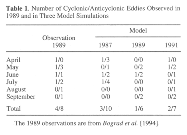
| Table 1. Number of Cyclonic/Anticyclonic Eddies Observed in 1989 and in Three Model Simulations | ||||
| Model | ||||
| Observation | ||||
| 1989 | 1987 | 1989 | 1991 | |
| April | 1/0 | 1/3 | 0/0 | 1/0 |
| May | 1/3 | 0/1 | 0/2 | 1/2 |
| June | 1/1 | 1/2 | 1/2 | 0/1 |
| July | 1/2 | 1/4 | 0/0 | 0/1 |
| August | 0/1 | 0/0 | 0/0 | 0/1 |
| September | 0/1 | 0/0 | 0/2 | 0/2 |
| Total | 4/8 | 3/10 | 1/6 | 2/7 |
| The 1989 observations are from Bograd et al. [1994]. | ||||
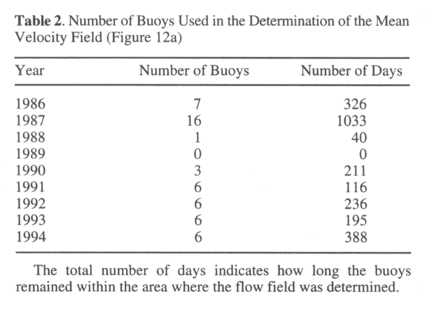
| Table 2. Number of Buoys Used in the Determination of the Mean Velocity Field (Figure 12a) | ||
| Year | Number of Buoys | Number of Days |
| 1986 | 7 | 326 |
| 1987 | 16 | 1033 |
| 1988 | 1 | 40 |
| 1989 | 0 | 0 |
| 1990 | 3 | 211 |
| 1991 | 6 | 116 |
| 1992 | 6 | 236 |
| 1993 | 6 | 195 |
| 1994 | 6 | 388 |
| The total number of days indicates how long the buoy remained within the area where the flow field was determined. | ||
Return to previous section or go back to Abstract