U.S. Dept. of Commerce / NOAA / OAR / PMEL / Publications
An eddy-resolving model of circulation on the western Gulf of Alaska shelf. 2.
Comparison of results to oceanographic observations
P. J. Stabeno
Pacific Marine Environmental Laboratory, NOAA, Seattle, Washington
A. J. Hermann
Joint Institute for the Study of the Atmosphere and Ocean, University of Washington,
Seattle
(Also at Pacific Marine Environmental Laboratory, NOAA, Seattle, Washington)
Journal of Geophysical Research, 101(C1), 1151-1161 (1996).
Copyright ©1996 by the American Geophysical Union. Further electronic distribution is not
allowed.
Comparison Between Observations and Model Simulations
Eddies
Eddies are an integral part of the flow field in the Shelikof sea valley and,
apparently, enhance larval survival [Schumacher
et al., 1993; Bograd
et al., 1994]. Noting this, it is important that the model generate
eddies at the same rate and size as observed in the data (at least in a statistical
sense). Eddies are generated in Shelikof Strait, primarily as a result of baroclinic
instabilities, which are common there [Bograd
et al., 1994; Mysak
et al., 1981]. The eddies in the Shelikof sea valley generally range
in diameter from 20 to 45 km, with peak rotational speeds of ~30 cm s [Bograd
et al., 1994], although larger eddies have been observed in satellite
images and satellite-tracked drifting buoy trajectories. The eddies generated
by the model were generally larger (~60 km) than those observed in the data
and rotated more slowly (~20 cm s). The
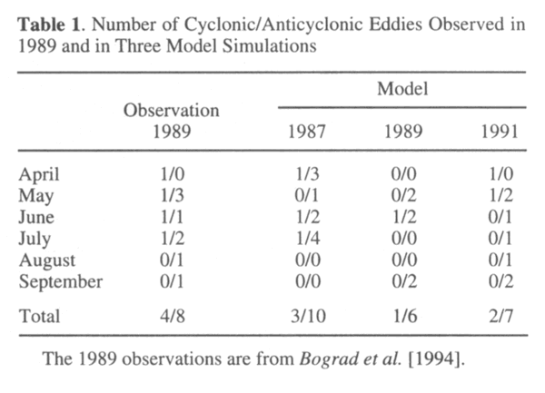
number of eddies generated in model simulations during each of 3 years was similar
to the number observed in 1989, when a census of eddies was conducted (Table
1). Model simulations and observations showed the following similar characteristics:
cyclonic eddies were generally observed between April and May and not during
August and September; in contrast, anticyclonic eddies were evident throughout
the observation period; and each year, anticyclonic eddies occurred more frequently
than cyclonic eddies.
[Bograd
et al., 1994], although larger eddies have been observed in satellite
images and satellite-tracked drifting buoy trajectories. The eddies generated
by the model were generally larger (~60 km) than those observed in the data
and rotated more slowly (~20 cm s). The
number of eddies generated in model simulations during each of 3 years was similar
to the number observed in 1989, when a census of eddies was conducted (Table
1). Model simulations and observations showed the following similar characteristics:
cyclonic eddies were generally observed between April and May and not during
August and September; in contrast, anticyclonic eddies were evident throughout
the observation period; and each year, anticyclonic eddies occurred more frequently
than cyclonic eddies.
If your browser cannot view the following table correctly,
click this link for a GIF image of Table
1
| Table 1. Number of Cyclonic/Anticyclonic
Eddies Observed in 1989 and in Three Model Simulations |
|
|
|
|
Model |
|
|
Observation |
|
|
1989 |
1987 |
1989 |
1991 |
|
| April |
1/0 |
1/3 |
0/0 |
1/0 |
| May |
1/3 |
0/1 |
0/2 |
1/2 |
| June |
1/1 |
1/2 |
1/2 |
0/1 |
| July |
1/2 |
1/4 |
0/0 |
0/1 |
| August |
0/1 |
0/0 |
0/0 |
0/1 |
| September |
0/1 |
0/0 |
0/2 |
0/2 |
|
|
|
|
|
| Total |
4/8 |
3/10 |
1/6 |
2/7 |
|
| The 1989 observations are from Bograd
et al. [1994]. |
The somewhat larger eddy scale observed in the simulations may be due, in part,
to how the freshwater is added to the model. As described by Hermann
and Stabeno [this issue], the salinity field is freshened at the coast
upstream (northeast) of Shelikof Strait to represent freshwater input along
the Gulf of Alaska. The length of coastline along which this input is distributed
is shorter in the model than in the true gulf, due to the limited spatial domain
of the former. This may result in stronger cross-shelf salinity gradients in
the model, leading to larger Rossby radii and hence larger diameters of eddies
produced through baroclinic instability.
In the model, large eddies (both cyclonic and anticyclonic) were generated
at the onset of a storm, when a pulse of freshwater (salinity <31.0 practical
salinity units (psu)) was forced down the strait. The cross-strait salinity
gradient doubled from ~0.3 to ~0.6 psu during such events. An anticyclonic eddy
dominated the sea valley for 60 days during the 1989 model simulation (Figure
3). Although an eddy was not evident in the current meter records at that
time, features of similar size have been observed in the sea valley. During
1994 a large, cyclonic eddy was evident off Wide Bay in a satellite-tracked
drifting buoy trajectory (not shown). This eddy was similar in size (~60 km)
and location to that observed in the 1989 model simulation. Large eddies have
also been observed in sea surface temperature from advanced very high resolution
radar. During May 1987 one existed west of Kodiak Island for >10 days, with
speeds of 30 cm s-1 [Vastano
et al., 1992].
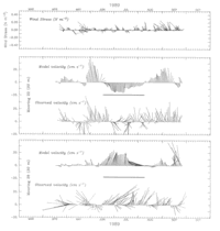
Figure 3. The wind stress at 57.5�N, 155�W and the daily velocity at
selected depths from current meter measurements and the 1989 model simulation.
Series were rotated to along isobath (220�T). The bold lines indicate when the
large eddy discussed in the text was present in the simulation.
Most eddies translated through the sea valley in a matter of weeks. In 1990
an anticyclonic eddy of smaller diameter (~25 km) was observed ~50 km to the
west of the Wide Bay moorings [Schumacher
et al., 1993]. This eddy remained stationary for at least 16 days, the
longest observation of a stationary eddy. This, of course, does not prove that
other eddies have not remained locked in position for a longer period, but none
has been observed. We suspect that the large eddy evident in the model simulations
of 1989 was stationary for a longer period than typical of eddies in the sea
valley.
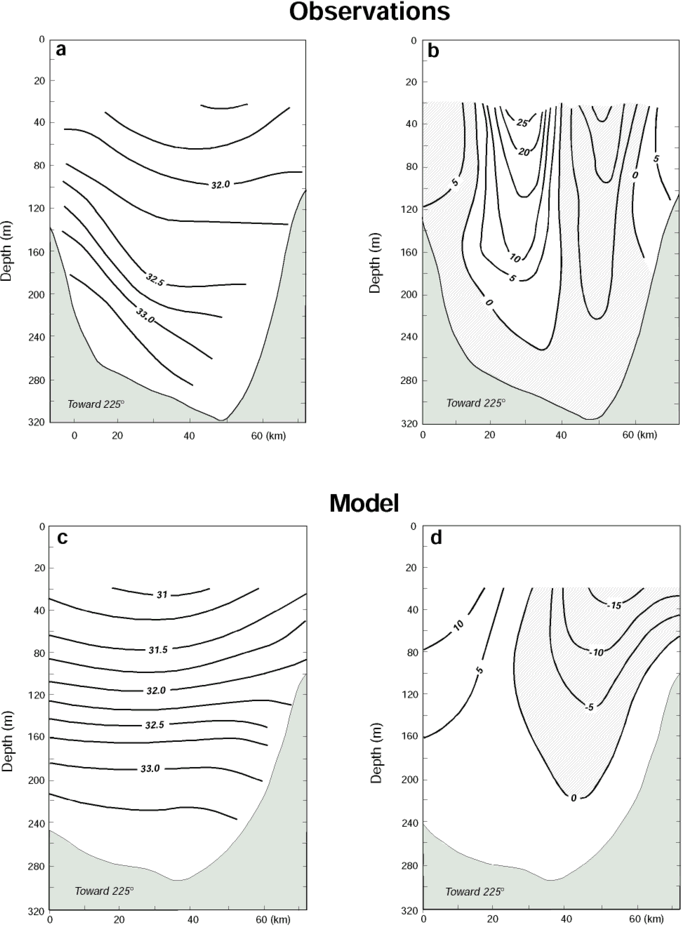
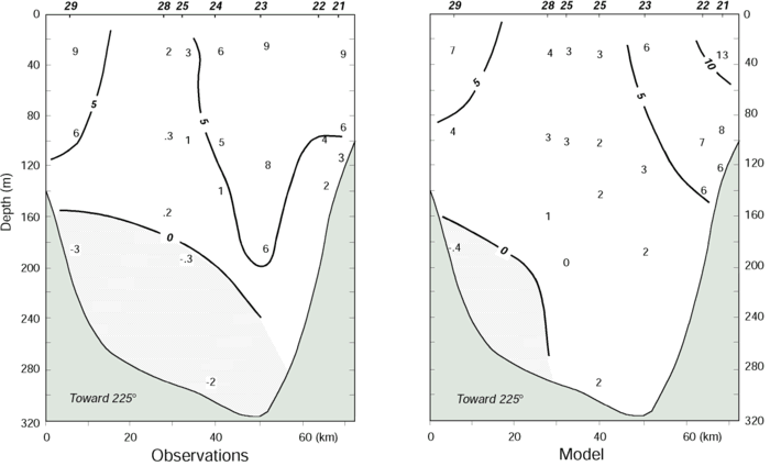
The vertical structure of a typical anticyclonic eddy (Figure
4) from the 1991 model simulations at Wide Bay was compared to an eddy observed
at the same location in 1989 [Bograd
et al., 1994]. The deformation of the salinity field (which at these
temperatures determines the density field) in both modeled and observed eddies
was greatest in the upper 100 m, while the velocity signature in both was evident
almost to the bottom. As is typically the case, the simulated eddy was larger
and not as intense as the observed eddy.
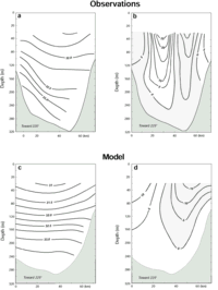
Figure 4. The (a) salinity (practical salinity units) and (b) velocity
(centimeters per second) structure of an eddy observed in the sea valley near
Wide Bay in 1989 (from Bograd
et al. [1994]) and the (c) salinity (practical salinity units) and (d)
velocity (centimeters per second) structure of an eddy near Wide Bay simulated
by the model. Hatched regions indicate flow toward the northeast (up the sea
valley).
Current Meter Observations
The large, anticyclonic eddy, spawned in Shelikof Strait during the 1989 model
simulation, remained stationary from June 21 to August 6 off Wide Bay. As a
result, the model simulation from 1989 was analyzed in two parts, April 27 to
June 21, when the model reproduced the low-frequency variability evident in
the observations; and after June, when the eddy dominated the currents (Figure
3). The signature of the model eddy is evident in the current time series,
with steady northwestward flow at mooring 22 and southeastward flow at mooring
25. Near the edge of the sea valley (mooring 22) the flow was generally along
the isobaths in both modeled and observed flow. Farther to the center of the
sea valley, however, strong across-shelf flow existed which was not reproduced
by the model. This was particularly evident in the measurements at mooring 28.
Correlations between modeled and measured currents, both for the entire record
length and for the noneddy period, were not significant at the 99% level.
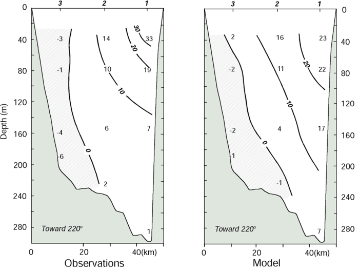
The current velocity between April 27 and June 21 (when the model currents
were not dominated by the large eddy) was used to calculate the mean flow normal
to the section (Figure 5). There was marked agreement
between the observed and modeled mean flow. In both the observations and model
simulations the strongest flow was toward the southwest on each side of the
sea valley, with weak flow near the middle (moorings 24-28). Although both observations
and simulations show estuarine inflow at depth, the modeled flow was weaker.
This is also evident in Figure 3. In general,
the shear was weaker in the model simulations than observations. The current
simulations also lacked the high-frequency variability evident in the observed
current.
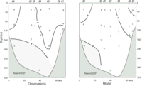
Figure 5. Cross section of mean alongshore current (centimeters per
second) observed off Wide Bay for the period April 27 through June 6, 1989,
from (a) current meter measurements and (b) model simulation. Hatched regions
indicate flow toward the northeast (up the sea valley). Mooring locations are
indicated at the top of each panel.
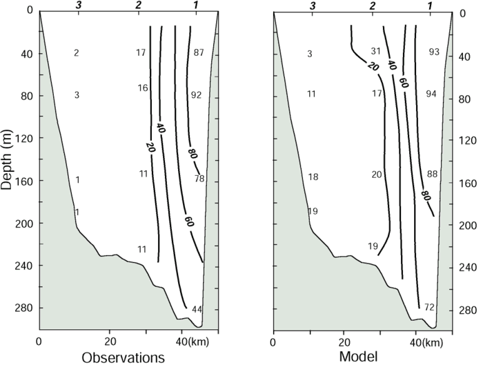
For 1991 the model reproduced the currents forced by the strong winds of spring
and fall better than events forced by the weaker winds of summer (Figure
6). As occurred in 1989, the flow near the edge of the sea valley was predominately
along the isobaths in both the model simulations and observation. Strong cross-shelf
flow occurred at the center of the strait in the observations (mooring 2), which
was not well simulated by the model. Significant correlation at the 99% level
between modeled and measured currents existed only at mooring 1.
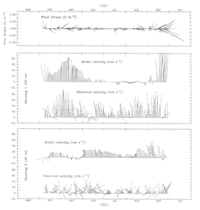
Figure 6. The wind stress at 57.5�N, 155�W and the daily velocity at
selected locations from current meter measurements and the 1991 model simulation.
Series were rotated to along isobath (220�T).
The mean along-sea valley flow for the period April 21-September 28, 1991 (Figure
7), revealed results similar to those for 1989. Once again, there was marked
agreement in the general pattern and magnitude of flow generated by the model
and measured by current meters. The flow was strongest along the peninsula (mooring
1), with inflow occurring on the Kodiak Island side (mooring 3) of the strait.
Again, the shear was weaker in the model results than in the observations. The
reduced shear may be due to excessive vertical mixing in the model required
for numerical stability. A comparison of terms for the salt balance in Shelikof
Strait suggests that vertical mixing is, on average, ~35% as large as the horizontal
advection term; this may be unrealistically large at middepth. (As noted by
Hermann
and Stabeno [this issue], horizontal mixing is generally insignificant
in this balance.)
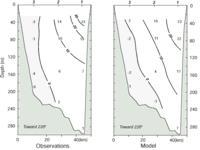
Figure 7. Cross section of the mean alongshore current (centimeters
per second) observed off Cape Kekurnoi for the period April 8 through September
30, 1991, from (a) current meter measurements and (b) model simulation. Hatched
regions indicate flow toward the northeast (up the sea valley). Mooring locations
are indicated at the top.
Transport
Time series of transport from current meter records for 1989 and 1991 were
compared with the modeled transport (Figure 8).
The large eddy, which dominated the currents in 1989 in the model simulations,
reduced transport. While the response of transport to strong wind events was
evident in both the measured and the modeled transport for both years, the modeled
transport was larger by a factor of 2 on several occasions. This was particularly
evident in late May 1989 and September 1991 and, to a lesser extent, in September
1989. The mean transport during 1989 (0.5 � 10 m
m s) compared
well with that simulated by the model (0.6 � 10
m s). For
1991, however, the modeled transport (1.0 � 10
m s) was
larger than that observed (0.6 � 10 m
s), primarily because the model overestimated
transport in September. Correlation between the measured and modeled transport
for 1989 was less (r = 0.45) than for 1991 (r = 0.60).
s) compared
well with that simulated by the model (0.6 � 10
m s). For
1991, however, the modeled transport (1.0 � 10
m s) was
larger than that observed (0.6 � 10 m
s), primarily because the model overestimated
transport in September. Correlation between the measured and modeled transport
for 1989 was less (r = 0.45) than for 1991 (r = 0.60).
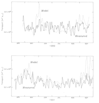
Figure 8. Time series of transport (as measured by current meters and
simulated by the model) through (a) the section off Wide Bay (1989) and (b)
through the section off Cape Kekurnoi (1991).
The spectra of the modeled and measured transport (Figure
9) compare well at frequencies below 0.35 cpd. At higher frequencies the
model transport had significantly less energy than the measured transport. For
both years the modeled and measured transport were coherent at the lowest-frequency
band (Figure 9). There was a lack of coherence
at the next frequency band and a return of significance in the weather band.
This pattern of coherence is similar to that observed between measured transport
and winds [Stabeno
et al., 1995b]. The coherence between the modeled transport and alongshore
wind also shows a lack of coherence at frequencies of ~0.09 cpd, with high coherences
at frequencies above and below.
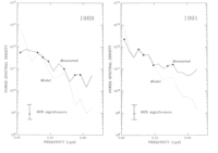
Figure 9. Spectra of the modeled and measured transport for (a) 1989
and (b) 1991. Frequencies at which the coherence between measured and modeled
transport was above 0.44 (95% significance level) are indicated with solid circles.
While the individual current time series are generally not correlated with
the alongshore winds (with the exception of mooring 1 from 1991), the transports
are. The lack of correlation between winds and individual current records was
due both to occurrence of eddies and to the variability in the location of the
high-speed core of the ACC. The significant correlations at mooring 1 were due
to the fact that the ACC primarily flows along the peninsula, and eddies tend
to quickly cross this region. The wind series used for comparison was the same
as that which forced the model. Thus we expected the correlations between modeled
transport and alongshore wind (r = 0.66, 0.70) to be higher than between
observed transport and alongshore wind (r = 0.47, 0.50) during 1989 and
1991, respectively. The correlations did not differ significantly between the
1989 and 1991 comparisons.
EOF Analysis
While empirical orthogonal function (EOF) analysis is often used to obtain
modes of motion that are related to dynamical modes, here we use this technique
to compare the principal modes of variability in the currents simulated by the
model with those measured by the current meters. During 1989 the horizontal
structure of the currents generated by the model were markedly different from
that observed because of the eddy which dominated model simulation that year.
Limiting our analysis to just the noneddy period results in time series which
are too short to significantly resolve the structure.
Noting this, we concentrate on the 1991 comparison (Figure
10). The first complex EOF mode accounted for 50% (66%) of the variance
in the measured (modeled) currents. Most of the energy in both the modeled and
observed current is concentrated along the Alaska Peninsula. The weaker vertical
shear in the model resulted in the reduced shear in the EOF of the modeled current
compared with measured; otherwise, the two patterns are markedly similar. Furthermore,
the time series of these EOFs were significantly correlated (r = 0.58).
The second-mode EOF accounted for ~20% of variance in both the modeled and measured
time series, but the time series were not significantly correlated nor were
the horizontal structures similar.
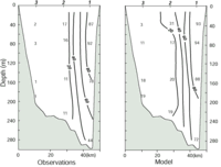
Figure 10. The horizontal structure for percent variance explained
by the first empirical orthogonal function mode at each current meter location
for (a) observed and (b) modeled currents during 1991.
Drifting Buoy Trajectories
There was a marked similarity between the float trajectories generated by the
model for 1987 and the trajectories of satellite-tracked drifting buoys for
that year (Figure 11). While the trajectories
have similar mean paths, their variability is not correlated. This is largely
due to the occurrence of eddies and their effect on a trajectory. An eddy is
clearly evident in the trajectories of the floats from the model in Figures
11b and 11d. This eddy delayed the exit of
these floats from the sea valley for ~50 days. For the two floats that were
not entrained in the eddy (Figures 11a and 11c)
the transit time through the sea valley was very similar to that of the satellite-tracked
buoys (<40 days). A general tendency of buoys was similar to that of model
floats; that is, buoys deployed (or floats seeded into the model) nearest the
Alaska Peninsula tend to continue along the coast (not shown), while those started
toward the middle of the strait and nearer Kodiak Island tend to follow the
sea valley.
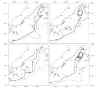
Figure 11. Trajectories of four buoys deployed in 1987 (thin solid
lines) compared with buoys seeded at the same location and time into the model
simulations (thick solid lines). Solid circles indicate every 10 days.
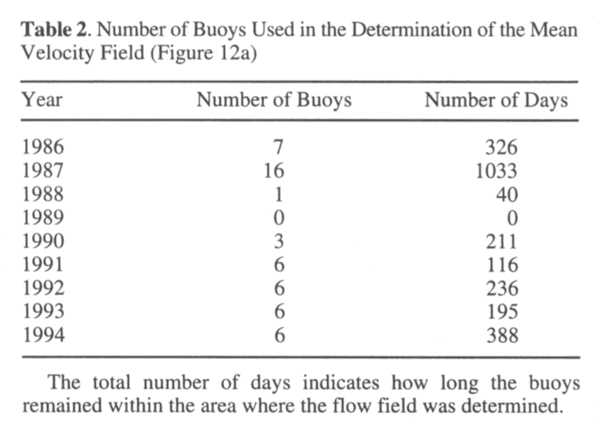
The trajectories from 51 satellite-tracked buoys were used to derive a mean
velocity field at 40 m (Figure 12a), following
Stabeno
and Reed [1991]. While most buoys were from 1987, every year but 1989
was represented (Table 2). The data come predominantly from April-October. The
measured drift velocities were averaged in 25 � 25 km bins and interpolated
to the velocity field shown in Figure 12a. The
mean (April-September) horizontal velocity field at 40 m from the model for
each of the 3 years already discussed is also shown (Figures
12b-12d). There is good agreement between the current patterns derived from
the satellite-tracked drifting buoys and the model, especially for 1987, although
there is significant variability between years in the model results. The simulations
for 1989 had the weakest mean flow, while the simulations for 1987 and 1991
had stronger flow, similar to the drifter-derived pattern.
If your browser cannot view the following table correctly,
click this link for a GIF image of Table
2
| Table 2. Number of Buoys
Used in the Determination of the Mean Velocity Field (Figure
12a) |
|
| Year |
Number of Buoys |
Number of Days |
|
| 1986 |
7 |
326 |
| 1987 |
16 |
1033 |
| 1988 |
1 |
40 |
| 1989 |
0 |
0 |
| 1990 |
3 |
211 |
| 1991 |
6 |
116 |
| 1992 |
6 |
236 |
| 1993 |
6 |
195 |
| 1994 |
6 |
388 |
|
| The total number of days indicates how
long the buoy remained within the area where the flow field was determined. |
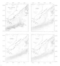
Figure 12. Maps of horizontal currents at 40 m (a) generated from the
trajectories of 51 satellite-tracked drifting buoys and simulated by the model
for (b) 1987, (c) 1989, and (d) 1991.
The modeled and observed coastal flow fields were all dominated by the ACC
which flows to the southwest through Shelikof sea valley (~25 cm s).
The mean velocity field showed a strong return flow onto the shelf south of
the Semidi Islands, which flowed offshore at the Shumagin Islands. This pattern
was also evident in the 1987 computer simulation and, to a lesser extent, in
1989 and 1991. The flow (~10 cm s) which
occurred along the peninsula, however, was largely absent from each of the model
simulations. This is likely caused by the strong tendency of the currents in
the model to follow the bathymetry and thus flow down the sea valley. Another
source of this discrepancy is the smoothed bathymetry used by the model; narrow
areas of >40 m depth in the near-coastal region were often excluded. Since
1989 had no satellite-tracked drifting buoys, the lack of similarity in the
strength of the currents between the observed and modeled flow from 1989 is
not surprising. The Alaskan Stream in the model was wider and weaker than observed
in the data because the model was limited to a maximum depth of 500 m.
Since eddies were not produced at the same time in the model as in the sea
valley, correlations between records that included eddy variability are poor.
Once the data are integrated in time or space (thus removing the effect of the
randomly spaced eddies), the comparisons are very good. Correlations between
individual observations and model simulations can hopefully be improved by assimilation
of current meter data. This particular problem will be explored in the future.
Acknowledgments. We thank T. Royer for runoff data from the
Alaskan coast. Simulations were performed on a Cray Y-MP with generous support
from the Arctic Region Supercomputing Center, Fairbanks, Alaska. This is contribution
FOCI-0221 to Fisheries Oceanography Coordinated Investigations, PMEL contribution
1612, and contribution 265 from the Joint Institute for the Study of the Atmosphere
and Oceans under cooperative agreement NP90RAH00073.
Return to previous section or go to next section
PMEL Outstanding Papers
PMEL Publications Search
PMEL Homepage


