U.S. Dept. of Commerce / NOAA / OAR / PMEL / Publications
Volume transport in the Alaska Coastal Current
James D. Schumacher, Phyllis J. Stabeno, and Andrew T. Roach
NOAA/Pacific Marine Environmental Laboratory, Seattle, Washington
Continental Shelf Research, 9(12), 1071-1083 (1989)
Not subject to U.S. copyright. Published in 1990 by Pergamon Press.
Nine moorings were deployed in three sections in the Shelikof Strait/Semidi Islands
region of the Alaskan continental shelf during the period of August 1984 to July 1985.
Analysis of the resulting current and bottom pressure data, together with surface wind,
provides a new understanding of transport in the Alaska Coastal Current. Using current
observations, mean volume transport through the Shelikof sea valley was computed to be
0.85 × 10 m
m s
s , which is in good agreement with estimates of transport
obtained from hydrographic data. Approximately 75% of this flux flowed seaward through the
Shelikof sea valley, with the remainder flowing along the Alaska Peninsula. Data showed
the expected increase of volume transport concomitant with maximum freshwater discharge in
autumn. The greatest monthly mean transport, however, occurred in winter and was related
to wind forcing. On time intervals of days, fluctuations in transport were often large (up
to 3.0 × 10 m s), and generally geostrophic ( r = 0.79). Some of
these fluctuations resulted from convergence of flow caused by the complex interaction of
storms with orography. Approximately half of the fluctuations in volume transport were
accounted for by the alongshore wind.
, which is in good agreement with estimates of transport
obtained from hydrographic data. Approximately 75% of this flux flowed seaward through the
Shelikof sea valley, with the remainder flowing along the Alaska Peninsula. Data showed
the expected increase of volume transport concomitant with maximum freshwater discharge in
autumn. The greatest monthly mean transport, however, occurred in winter and was related
to wind forcing. On time intervals of days, fluctuations in transport were often large (up
to 3.0 × 10 m s), and generally geostrophic ( r = 0.79). Some of
these fluctuations resulted from convergence of flow caused by the complex interaction of
storms with orography. Approximately half of the fluctuations in volume transport were
accounted for by the alongshore wind.
Introduction
During the past decade, knowledge of the physical oceanography of the Gulf
of Alaska has grown substantially. Discovery of the Alaska Coastal Current (ACC),
a narrow coastal jet extending more than 1000 km along the coast (Fig.
1), was one of the most important advances. This is a vigorous coastal current
with speeds as large as 175 cm s . Transport
is driven by the large flux of freshwater along the coast of Alaska (Royer,
1982). The alongshore wind perturbs this flow through both confinement of the
freshwater and alteration of coastal sea level (Schumacher
and Reed, 1980; Royer,
1981; Reed
and Schumacher, 1981). Between Kodiak Island and the mainland, differential
Ekman pumping generates fluctuations in transport (Reed
and Schumacher, 1989). The maximum freshwater input is in autumn (Royer,
1982). Concomitantly, speeds in the ACC increase markedly and volume transport
is 2-3 times as great as observed during summer, often exceeding 1.9 × 10
m s . After
leaving the northeastern coast of Alaska, most of the ACC flows through Shelikof
Strait, with a portion continuing westward to Unimak Pass (Schumacher
and Reed, 1986). To date, all transport estimates have been based on hydrographic
data which are sensitive to the selection of a level of no motion.
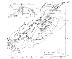
Figure 1. Study area setting. Positions of the nine moorings (dots) are indicated.
Mooring numbers are consecutive but only outer ones are labeled. Shown in the insert is
the regional circulation. Depths are in meters.
In this paper we present the first estimates of transport in the ACC computed using
current and bottom pressure records. These records were collected between August 1984 and
July 1985 in the western Gulf of Alaska (Fig. 1). This
experiment was part of Fisheries Oceanography Coordinated Investigations (FOCI), a
continuing NOAA program. The goal of FOCI is to understand biological and physical
processes influencing recruitment of pollock (Theragra chalcogramma) in Shelikof
Strait, Alaska. The objective of the research component presented here was to answer basic
questions regarding characteristics of transport, including: what fraction of the
transport is through the sea valley along the Alaska peninsula, and can transport be
monitored with bottom pressure observations?
A description of current and bottom pressure data obtained during this experiment,
together with surface winds, is presented in Roach
et al. (1987). Reed
et al. (1987) present a comprehensive analysis of hydrographic data
collected in March and July 1985. The focus of this paper is to describe transport,
to examine mechanisms causing fluctuations, and to investigate geostrophy.
Observations
The observational program
During 1984 and 1985, 35 current meters and six pressure gauges (Aanderaa model RCM-4
and WLR-5 or TG-3) were deployed on nine taut-wire moorings in the western Gulf of Alaska
(Fig. 1). The moorings were arranged in three sections;
data was recorded at section 1 (moorings 1, 2 and 3) for 5 months (August 1984 to January
1985) and at sections 2 (moorings 4, 5 and 6) and 3 (moorings 6, 7 and 8) for 11 months
(August 1984 to July 1985). Current meter depths and locations are shown in Fig. 2. Some instruments measured temperature and conductivity
which were used to estimate salinity. The six bottom pressure gauges were located one at
each end of a section. All gauges were mounted in a well on the anchor to avoid the
effects of mooring motion.

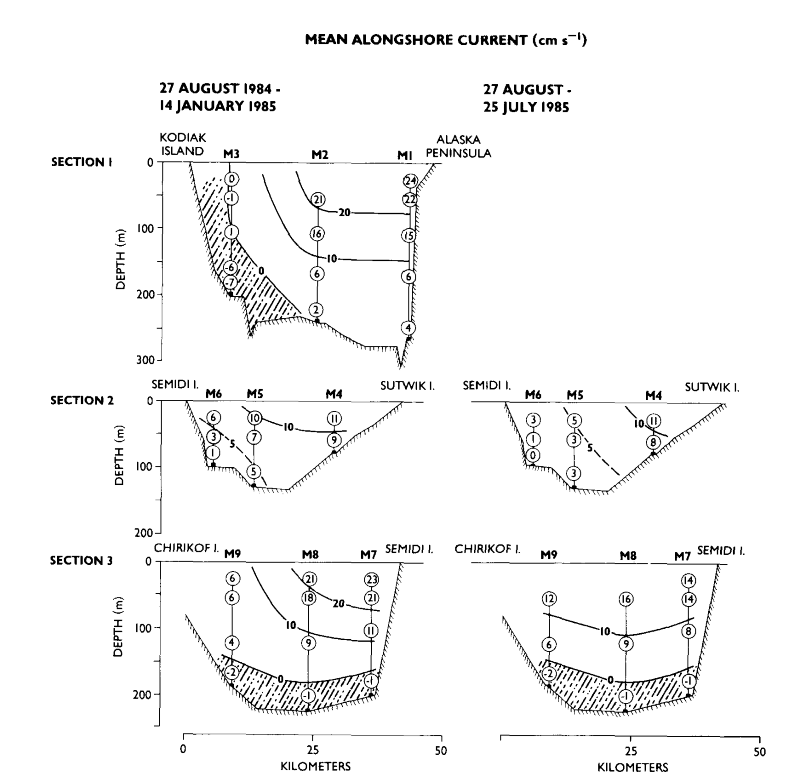
Figure 2. Mean current velocity observed at section 1 (top), section 2 (middle) and
section 3 (bottom). Contours of the alongshore (220°T, 250°T and 190°T for sections 1,
2 and 3, respectively) component of velocity are shown in the left column for the period
27 August 1984 to 14 January 1985, and in the right column for the period 27 August 1984
to 25 July 1985. Shaded areas represent inflow.
Surface winds were computed from 6-hourly atmospheric surface pressure supplied by the
Fleet Numerical Oceanography Center. These are geotriptic winds (a balance of Coriolis,
pressure gradient, centrifugal and friction forces) which were rotated 15°
counterclockwise, reduced in speed by 30% from the geostrophic wind, and interpolated to
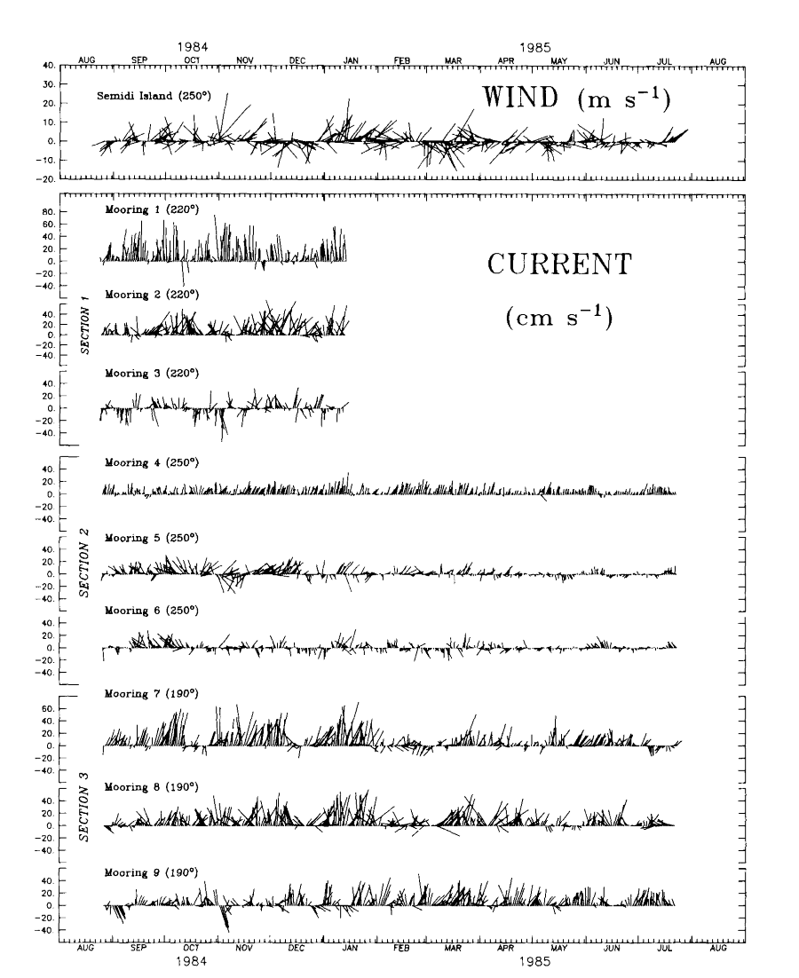
the vicinity of Semidi Islands (Fig. 3).
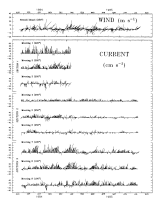
Figure 3. Current time series from a nominal depth of 56 m. The daily vectors are
shown relative to the axis of each section (given in parentheses).
The data
Since tides dominated the bottom pressure spectrum, the pressure records were detided
prior to low-pass filtering and removing linear trends. The current and detided bottom
pressure data were low-pass filtered with a cosine-squared tapered Lanczos filter and
resampled at 6-hourly intervals. This filter passes more than 99% of the amplitude at
periods greater than 44 h, 50% at 35 h and less than 0.5% at 25 h, effectively removing
the tidal signal from the current records. Examples of low-pass filtered currents are
shown in Fig. 3.
Estimates of transport were calculated from the current velocity components normal to
each section, multiplied by estimates of cross-sectional area. These areas were computed
as follows. Detailed bathymetry was compiled for each section using information from
continuous depth recordings, soundings at CTD stations and standard charts. Between
moorings, the midpoint was used to define the horizontal extent assigned a given current
velocity. The horizontal length between a mooring and the edge of a section varied. At
section 1, current was assumed to occur only seaward of mooring 1 and to extend from
mooring 3 to Kodiak Island. At section 2, the current was assumed to extend halfway
between the outer two moorings and the adjacent land. At section 3, the current was taken
to extend halfway between mooring 7 and Semidi Island but only one-third of the way (a
depth of 100 m) to Chirikof Island. The vertical length at each mooring was selected as
the midpoint between adjacent current meters. For example, the velocity from instruments
at a nominal depth of 26 m (the next current meter was at 56 m) was assigned to the upper
41 m of the water column. We assumed no shear in current velocity within a transport
layer. Velocity was set at zero approximately 5 m above the bottom. All results presented
here are based on 6-hourly time series.
Mean and low-frequency transport. The structure of the mean alongshore
current shows the local manifestation of the ACC. During the period August to
January (Fig. 2, left column), the ACC was strongest
(>20 cm s) in the upper 150 m on the
northwest or west side of the sea valley at sections 1 and 3. The portion of
the ACC which continued along the Peninsula (section 2), rather than following
the sea valley (section 3), shows more moderate (~10 cm s)
flow. Inflow occurred in both sea valley sections (1 and 3). When averages over
the entire observation period (August 1984 to July 1985: Fig.
2, right column) are considered, the flow pattern at section 3 is changed
substantially from the August to January mean. Maximum velocities were smaller
and more evenly distributed across the sea valley, although inflow remained
on the bottom. This inflow supports conclusions from hydrographic data that
an "estuarine-like" or two-layered flow exits (Reed
et al., 1987) and emphasizes the care required in selecting a level
of no motion for baroclinic calculations (Reed
and Schumacher, 1989).
From August 1984 to January 1985 the mean and r.m.s. error of the volume flux through
section 1 (
 ) was 0.81 ± 0.13 × 10 m s and the sum of the
transport through the other two sections was 0.26 ± 0.04 (
) was 0.81 ± 0.13 × 10 m s and the sum of the
transport through the other two sections was 0.26 ± 0.04 ( ) +
0.68 ± 0.11 (
) +
0.68 ± 0.11 ( ) = 0.94 ± 0.13 × 10 m s (
 ). During this interval, transport balanced to
within 15%. For the longer time interval (August 1984 to July 1985), mean volume transport
in the ACC was calculated to be 0.19 ± 0.02 () + 0.66 ± 0.08 () =
0.85 ± 0.10 × 10 m s ().
). During this interval, transport balanced to
within 15%. For the longer time interval (August 1984 to July 1985), mean volume transport
in the ACC was calculated to be 0.19 ± 0.02 () + 0.66 ± 0.08 () =
0.85 ± 0.10 × 10 m s ().
Time series of transport through each of the three sections and T are shown in Fig.
4. The time series T was
formed by adding the 6-hourly low-pass filtered transport data from sections 2 and 3;
statistics were computed from this new series. All series had high frequency (0.2-0.5 cpd)
fluctuations which became less prominent after May. These fluctuations were superimposed
on a very low frequency signal (~0.03 cpd) which also decreased in amplitude in spring.
There were four identifiable events in T (Fig. 4, Table 1), each lasting more than 10
days, during which transport exceeded the mean (0.85 × 10
m s). To help
visualize these events, we applied a 10-day running mean to the transport series T. The average duration of these events were 23
days with a standard deviation of 11 days. During these pulses, the average transport was
1.49 × 10 m s. The event with maximum transport occurred during January.
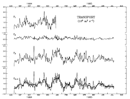
Figure 4. Time series of transport through sections 1, 2, 3 and the sum of T + T. (The heavy line is a 10-day running mean.)
If your browser cannot view the following table correctly, click this
link for a GIF image of Table 1.
TABLE 1. Statistics of very low
frequency events in the 6-hourly total (T  ) transport time series.
R.M.S. error estimates were calculated from the quotient of the standard deviation divided
by the square root of the ratio of the record length divided by the integral time scale
) transport time series.
R.M.S. error estimates were calculated from the quotient of the standard deviation divided
by the square root of the ratio of the record length divided by the integral time scale
|
| Event no. |
Observation period |
Duration |
Volume transport ± r.m.s error |
|
|
(days) |
10 mł s |
|
| 1 |
29 September, 0600 |
15.75 |
1.29 ± 0.12 |
|
15 October, 0000 |
|
|
| 2 |
14 November, 1200 |
31.0 |
1.39 ± 0.16 |
|
15 December, 0600 |
|
|
| 3 |
29 December, 1800 |
33.75 |
1.71 ± 0.15 |
|
31 January, 0600 |
|
|
| 4 |
14 March, 1800 |
12.75 |
1.56 ± 0.20 |
|
27 March, 0600 |
|
|
|
Although the transport time series are rich in variability, spectral analysis
showed no significant peaks (at the 95% significance level). For each series
at least 66% of the variance occurred at periods longer than 10 days. The baroclinic
instability identified in previous current data from Shelikof Strait was thought
to be the source of most of the low-frequency current fluctuations (Mysak
et al., 1981). This signal is clear in the current record from mooring
2 where the current vectors rotate back and forth across the section. Similar
motion appears to a lesser degree at mooring 8. Analysis of current spectra,
however, indicate that only at mooring 2 was the spectral peak statistically
significant (Roach
et al., 1987). In the time series of volume transport, baroclinic
instability was not a mechanism generating significant variability.
Relationships between transport time series. Fluctuations in transport through
sections 2 and 3 were best correlated with those upstream through section 1 and were not
significantly correlated with each other (Table 2). Fluctuations in T accounted for over half of those in T. For all pairs, most of the coherent signal
was in the longest period band (>19 days). Transports through sections 2 and 3 were
coherent in only one frequency band (4.6-5.1 days) and this accounted for less than 6% of
the total variance.
If your browser cannot view the following table correctly, click this
link for a GIF image of Table 2.
Table 2. Correlations at the 95% level
between transport through section 1 (T), section
2 (T), section 3 (T), and section 2 + section 3 (T )
|
|
|
Variance (%) |
|
| Transport |
T |
T |
T |
|
| T |
100 |
|
|
| T |
22 |
100 |
|
| T |
51 |
– |
100 |
| T |
58 |
25 |
92 |
|
Numbers give the percent variance (r˛ × 100) in each
row which is
explained by the column. Dashes indicate no significant correlation. |
Discussion
Forcing mechanisms
The primary cause of the annual variation in transport in the ACC is the freshwater
runoff whose maximum occurs in autumn (Schumacher
and Reed, 1980; Royer,
1981, 1982).
The major source of this runoff is along the east and north coast of Alaska,
before the ACC enters Shelikof Strait. Estimates of geostrophic transport based
on CTD data from 20 occupations of seven stations along section 1 and collected
between March 1985 and June 1988 yield a mean and standard deviation of 0.59
± 0.32 × 10 m
s. The reference levels used for geostrophic
transport calculations vary across the section (Reed
and Schumacher, 1989; Fig. 2). There were
no CTD surveys during winter. The maximum of 1.18 × 10
m s occurred
in October 1985. The mean and standard deviation compares favorably with values
estimated from current records:
= 0.81 ± 0.59 × 10 m
s, or
= 0.85 ± 0.68 × 10 m
s.
There was also good agreement between calculated and observed transport over shorter
time intervals. From 25 to 26 March 1985, CTD data were collected at stations along
sections 2 and 3, providing estimates of 0.01 × 10 and
0.85 × 10 m s, respectively. (For the same time, current data were used
to establish a 190-dbar level of no motion for section 3.) From current records the values
were 0.05 and 0.86 × 10 m s, for sections 2 and 3,
respectively.
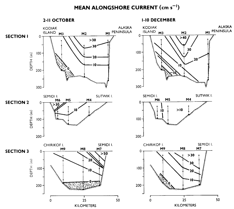
Volume transport during October 1984 (Table
1) was enhanced by the maximum freshwater accumulation. Since there is no
hydrographic data, we examine the current structure (Fig.
5) and salinity from moored instruments. During October, the largest current
speeds and the greatest vertical shear occurred in the vicinity of moorings
6 and 7. This was accompanied by a marked increase in current speed and a decrease
in salinity of approximately 1 psu at moorings 4-7 in the upper 56 m of the
water column. Both of these changes are consistent with observations made in
autumn 1978 (Schumacher
and Reed, 1986). We conclude that strong vertical shear and a narrow band
of high speeds and marked decrease in salinity (as observed in October 1984)
are features of the enhanced geostrophic transport associated with the large
increase of freshwater which occurs during autumn.

Figure 5. Structure of the mean current for (a) 2-11 October and (b) 1-10 December
1984. Volume transport at section 1 was 1.4 × 10 (1.7 ×
10), for section 2, 0.4 × 10 (0.5 × 10) and section 3,
1.0 × 10 (1.3 × 10) m s for the October
(December) event.
Contrast these characteristics with those occurring during a transport pulse of similar
magnitude that occurred in December (Fig. 5). At section 1
the higher current speeds occurred over a greater area than in October, with strong
near-bottom flow toward the northeast compensating for increased southwestward flow. In
section 2, the maximum current was near mooring 4 rather than at mooring 6, and both here
and in section 3 vertical shear markedly decreased from values in October. Finally, there
was no accompanying decrease in salinity at any mooring. The remaining three pulses had
characteristics similar to those in December and represent fluctuations which were not
directly related to the seasonally varying flux of freshwater.
Most of the remaining fluctuations were most likely caused by wind forcing.
Early studies (Schumacher
and Reed, 1980; Royer,
1981; Reed
and Schumacher, 1981) suggest that the alongshore component of the wind
alters the cross-shelf distribution of mass and perturbs coastal sea level through
Ekman transport. In the vicinity of Kodiak Island, complex wind patterns result
from the interaction of storms with orography. Within the orographically bounded
region of Shelikof Strait proper, nearshore isopycnal surfaces appear to be
deepened through differential Ekman pumping (Reed
and Schumacher, 1989). This causes large, rapid perturbations (about 0.4
× 10 m s
in <3 days) in volume transport.
Because most of the sea valley is nearly parallel to and in close proximity of the
coast, Ekman-driven coastal convergence should be important. Between September 1984 and
January 1985, estimates of coherence (at the 95% level of significance) between the
alongshore component (240°T) of the surface wind at Semidi Islands and water transport
accounted for 39, 3 and 41% of the fluctuations in volume transport at sections 1, 2 and
3, respectively. For the series T
approximately 45% (50% for the 11-month time interval) of the variance in transport could
be explained by the alongshore wind.
Wind data collected from a research aircraft show convergence of geostrophic
and ageostrophic winds in the region between sections 1 and 2 (Macklin
et al., 1984). Under such meteorological conditions transport will
be enhanced toward the southwest in Shelikof Strait. At the same time, over
the open shelf west of Kodiak Island, onshore winds cause reduced transport
out of the system. As a result sea level increases in the region bounded by
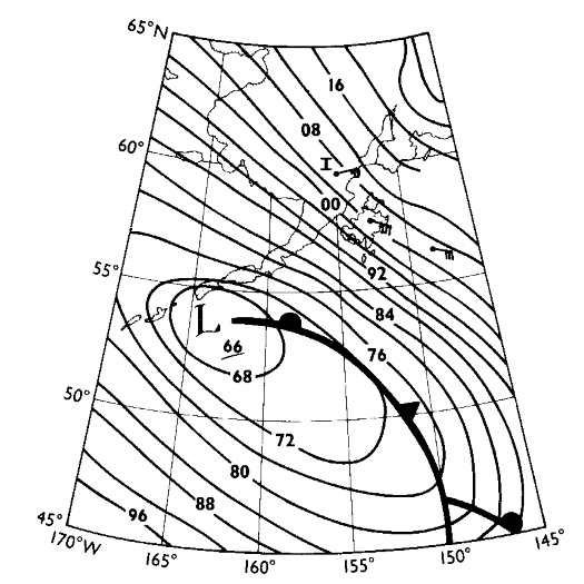
the three sections. For example, between 30 October and 2 November 1984, an
eastward-moving low pressure system passed within 250 km south of the study
area. The distribution of surface atmospheric pressure (Fig.
6) caused onshore surface (geotriptic) winds over the open shelf and down-gradient
(ageostrophic) winds in Shelikof Strait proper. Concomitant with the storm,
near-surface currents at moorings 5-7 reversed and those at mooring 1 increased
toward the southwest. As a result, transport through section 2 decreased markedly
(<0.02 × 10 m
s), transport through section 3 was reduced
and it increased through section 1. At all bottom pressure gauges the response
was an increasing positive anomaly (>15 mbar), with a maximum occurring after
about 36 h. As the storm moved eastward, wind forcing changed and the convergence
of water transport ceased. As the dome of water relaxed, transport seaward through
section 3 increased by as much as 4.3 times greater than the mean. Volume transport
then reversed at all locations as the system overshot equilibrium. The interaction
is reversible. A high pressure system southwest of the Shelikof region generates
offshore winds over the open shelf and northeastward winds in Shelikof Strait
which result in divergent transport. The strong reversal of transport which
occurred at the start of the time series in August is an example of such an
event.
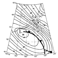
Figure 6. Sea level atmospheric pressure for 1200 on 31 October 1984. The wind barbs
are actual observations. Note how the barb at Iliamna (labeled I) indicates down-gradient
winds similar to those in Shelikof Strait. Surface wind at Semidi Island was 12.5 m s toward 300°T.
The integrated effect of storms also accounts for variations in volume transport
over longer time intervals. Data on principal tracks of centers of cyclones
at sea level (Mariner's
Weather Log, 1985) provide necessary information to estimate the possible
impact of storms. During January, five cyclones passed through the region bounded
by 50°-55°N, and 155°-165°W, on trajectories from south to north. During February,
only two storms passed through the southernmost portion of the area and they
were on eastward trajectories. The difference in number and trajectory of these
storms was reflected in the mean alongshore wind component (240°T) which reversed
from 5.2 m s in January to -0.2 m s
in February. Accompanying the difference in storm characteristics was a marked
difference between the monthly transport in January (1.74 × 10
m s) and
February (0.59 × 10 m
s ).
Geostrophy
One of the objectives of the field experiment was to determine if bottom pressure
measurements could be used to calculate transport. Following Brown
et al. (1987), fluctuations in transport are related to bottom pressure
via
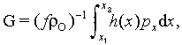 (1)
(1)
where x is the across-channel direction, G the geostrophic transport, p
the bottom pressure, 
 mean density, f Coriolis and h(x) depth. We have
neglected the two terms representing density anomalies, since the time series of salinity
and temperature were not complete enough to calculate density. Bottom pressure records
were limited to the endpoints of each section, so we assume that h(x) = H, a
constant. Deviation from this assumption was greatest at section 1 (30%) and least at
section 3 (<10%). The correlations of transports with their associated pressure
differences at sections 2 and 3 accounted for 50 and 62% of transport fluctuations,
respectively. At section 1 there was no significant correlation. This was probably caused
by two factors. The first is the deviation of h(x) from constant value; the
second is the strength of density anomalies which are largest at section 1 since it is
nearer the freshwater sources.
mean density, f Coriolis and h(x) depth. We have
neglected the two terms representing density anomalies, since the time series of salinity
and temperature were not complete enough to calculate density. Bottom pressure records
were limited to the endpoints of each section, so we assume that h(x) = H, a
constant. Deviation from this assumption was greatest at section 1 (30%) and least at
section 3 (<10%). The correlations of transports with their associated pressure
differences at sections 2 and 3 accounted for 50 and 62% of transport fluctuations,
respectively. At section 1 there was no significant correlation. This was probably caused
by two factors. The first is the deviation of h(x) from constant value; the
second is the strength of density anomalies which are largest at section 1 since it is
nearer the freshwater sources.
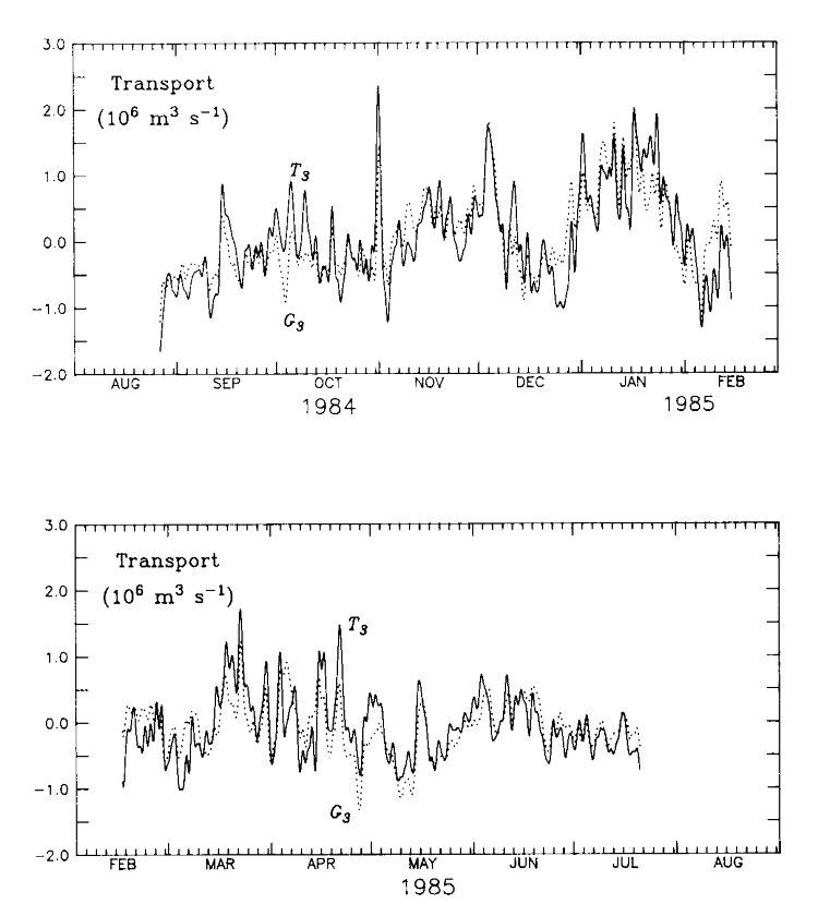
For section 3, the geostrophic transport was calculated using equation (1) with = 1 g cm , f = 1.23 × 10
 and H = 205 m. Shown in Fig. 7 are the demeaned and
detrended transports, calculated from the velocity records (T ) and the geostrophic relationship (G). The fluctuations calculated using equation (1)
were nearly of the same magnitude as those observed; a least squares fit of T =
and H = 205 m. Shown in Fig. 7 are the demeaned and
detrended transports, calculated from the velocity records (T ) and the geostrophic relationship (G). The fluctuations calculated using equation (1)
were nearly of the same magnitude as those observed; a least squares fit of T =  G + e yields = 0.94. The balance held for many of the strong pulses, at
both short and long periods and for both in- and outflow events. Except at a period of 10
days, the series were coherent (at the 95% level) and the phase did not differ
significantly from zero. The relationship between bottom pressure difference and transport
at section 2 was similar to the results at section 3.
G + e yields = 0.94. The balance held for many of the strong pulses, at
both short and long periods and for both in- and outflow events. Except at a period of 10
days, the series were coherent (at the 95% level) and the phase did not differ
significantly from zero. The relationship between bottom pressure difference and transport
at section 2 was similar to the results at section 3.
Figure 7. The demeaned and detrended time series of transport through section 3 from
current records (T, solid line) and
from the bottom pressure records from moorings 7 and 9 (G, dotted line).
Conclusions
For the first time, estimates of volume transport in the ACC are available from both
moored current and bottom pressure records. Our field observations from the Shelikof sea
valley and adjacent shelf region between August 1984 and July 1985 lead to the following
conclusions:
1. The mean volume transport of the ACC calculated from current records was 0.85 × 10 m s. This is in good agreement with estimates of transport
from CTD data (provided that the level of no motion is carefully selected to approximate
the two-layered velocity field generally present over the sea valley). Approximately 75%
of the mean transport was through the sea valley with the remaining flux along the Alaska
Peninsula. There was a relative volume transport maximum (>1.0 × 10 m s) associated with accumulation of freshwater in autumn. The
greatest monthly transport, however, occurred in winter and were associated with
wind-driven perturbations.
2. Wind forcing was the primary cause of fluctuations in transport. This occurred
through Ekman convergence, Ekman pumping (resulting from the curl of the wind stress), and
the convergence of transport through Shelikof Strait with that over the open shelf. From
estimates of coherence, about half of the transport fluctuations in the ACC were accounted
for by the alongshore wind.
3. At sections 2 and 3, transport fluctuations were generally geostrophic. Geostrophy
accounted for about 62% of the variance of transport at section 3 and 50% at section 2.
While neglecting the terms that are a function of density seemed of little consequence at
sections 2 and 3, estimates of geostrophic transport from bottom pressure across section 1
may require time series of density.
The new results further document the relatively vigorous nature of the ACC.
Mean transport here is similar in magnitude and more consistent in direction
than the northward flux through Bering Strait (Muench
et al., 1988; Coachman
and Aagaard, 1988). Volume transport in the ACC is also greater than observed
values for the east coast of North America. Estimates of transport along the
shelf of Nova Scotia indicate an annual mean flux of about 0.25 × 10
m s which
is related to outflow from the Gulf of St. Lawrence (Drinkwater
et al., 1979). Farther south along the coast at Nantucket Shoals,
estimates of annual mean volume transport were approximately 0.35 × 10
m s (Ramp
et al., 1988). Santa Barbara channel (off the west coast of North
America) is a region with similar topography to Shelikof Strait; however, forcing
for circulation here is oceanic rather than regional runoff. Estimates of transport
calculated from current data (Brink
and Muench, 1986) for a 2-month period indicate a mean volume flux similar
to those during winter in the ACC. Clearly, the ACC is one of the largest and
most consistent nearshore currents found along the North American coast.
Acknowledgments--We wish to thank the many people who assisted in field
operations, data processing and discussions. In particular we thank the complements of the
NOAA ships Fairweather and Discoverer and the USCG ship Firebush.
Special thanks to T. Jackson and W. Parker who prepared all the equipment and deployed and
recovered the moorings. L. Long and P. Proctor processed the time series with great care
and patience. Discussions with R. Reed, L. Incze and R. Romea were extremely useful.
Reviewers comments improved the manuscript. This publication is contribution 0071 to the
Fisheries Oceanography Coordinated Investigations (FOCI) of NOAA. Contribution no. 984
from Pacific Marine Environmental Laboratory.
References
Brink, K.H., and R.D. Muench (1986) Circulation in the Pt. Conception-Santa Barbara
channel region. Journal of Geophysical Research, 91, 877-895.
Brown, W.S., J. Irish, and C.D. Winant (1987) A description of subtidal pressure field
observations on the northern California continental shelf during the Coastal Ocean
Dynamics Experiment. Journal of Geophysical Research, 92, 1605-1636.
Coachman, L.K., and K. Aagaard (1988) Transports through Bering Strait: Annual and
interannual variability. Journal of Geophysical Research, 93, 15,535-15,539.
Drinkwater, K., B. Petrie, and W.H. Sutcliffe, Jr. (1979) Seasonable geostrophic volume
transports along the Scotian Shelf. Estuarine and Coastal Marine Science, 9,
17-27.
Macklin, S.A., J.E. Overland, and J.P. Walker (1984) Low-level gap winds in Shelikof
Strait. Third Conference on Meteorology of the Coastal Zone, AMS, Boston, Mass., pp.
97-102.
Mariner's Weather Log (1985) Principal tracks of centers of cyclones at sea level. Mariners
Weather Log, 29, 181-182.
Muench, R.D., J.D. Schumacher, and S.A. Salo (1988) Winter currents and hydrographic
conditions on the northern central Bering Sea shelf. Journal of Geophysical Research,
93, 516-526.
Mysak, L., R.D. Muench, and J.D. Schumacher (1981) Baroclinic instability in a
downstream varying channel: Shelikof Strait, Alaska. Journal of Physical Oceanography,
11, 950-969.
Ramp, S.R., W.S. Brown, and R.C. Beardsley (1988) The Nantucket Shoals Flux Experiment
3. The alongshore transport of volume, heat, salt and nitrogen. Journal of Geophysical
Research, 93, 14,039-14,054.
Reed, R.K., and J.D. Schumacher (1981) Sea level variations in relation to coastal flow
around the Gulf of Alaska. Journal of Geophysical Research, 86, 6543-6546.
Reed, R.K., and J.D. Schumacher (1989) On transport and physical properties in central
Shelikof Strait, Alaska. Continental Shelf Research, 9, 261-268.
Reed, R.K., J.D. Schumacher, and L.S. Incze (1987) Circulation in Shelikof Strait,
Alaska. Journal of Physical Oceanography, 17, 1546-1554.
Roach, A.T., J.D. Schumacher, and P. Stabeno (1987) Observations of currents, surface
wind and bottom pressure in Shelikof Strait, Alaska, autumn 1984. NOAA Technical
Memorandun ERL PMEL-74, 116 pp. (NTIS no. PB88-121736).
Royer, T.C. (1981) Baroclinic transport in the Gulf of Alaska. Part II. Fresh water
driven coastal current. Journal of Marine Research, 39, 251-266.
Royer, T.C. (1982) Coastal fresh water discharge in the northeast Pacific. Journal
of Geophysical Research, 87, 2017-2021.
Schumacher, J.D., and R.K. Reed (1980) Coastal flow in the northwest Gulf of Alaska:
the Kenai Current. Journal of Geophysical Research, 85, 5580-6688.
Schumacher, J.D., and R.K. Reed (1986) On the Alaska Coastal Current in the
western Gulf of Alaska. Journal of Geophysical Oceanography, 91,
9655-9661.
Return to Abstract
PMEL Outstanding Papers
PMEL Publications Search
PMEL Homepage