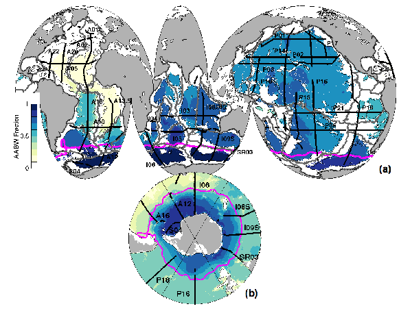
Fig. 1. (a) Tracklines of the 28 repeated sections studied (black lines) with WOCE designators noted adjacent. Basin boundaries are outlined (gray lines) over the depth-averaged fraction of AABW below 4000 m (color bar) after Johnson (2008). The Subantarctic Front (SAF; Orsi et al. 1995) position (magenta line) and the 4000-m isobath (thin black lines) are also shown. (b) As in (a) but a polar projection with tracklines of the nine repeated sections that extend south of the SAF plotted over the depth-averaged fraction of AABW from 1000 to 4000 m with the 1000-m isobath and without basin boundaries.
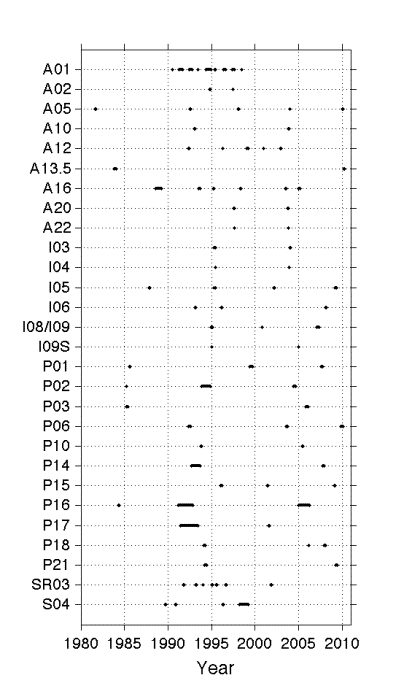
Fig. 2. Occupation dates for each of the 28 repeated sections analyzed here listed by their WOCE designators (see Fig. 1 for locations). Lines extend over the entire period over which data were collected for a given occupation of a section. Longer lines indicate where multiple legs of sections taken over the course of up to a year or more are joined.
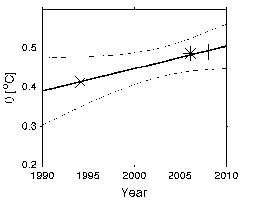
Fig. 3. Local dθ/dt estimate for a location with more than two section occupations. Potential temperature data (asterisks) from three occupations along P18 (see Fig. 4, green asterisk, for location) at 56°S and 4000 dbar plotted vs time are used to fit a line by least squares (solid line), producing an error estimate here shown at 95% confidence limits (dotted line). The slope of the line is dθ/dt.
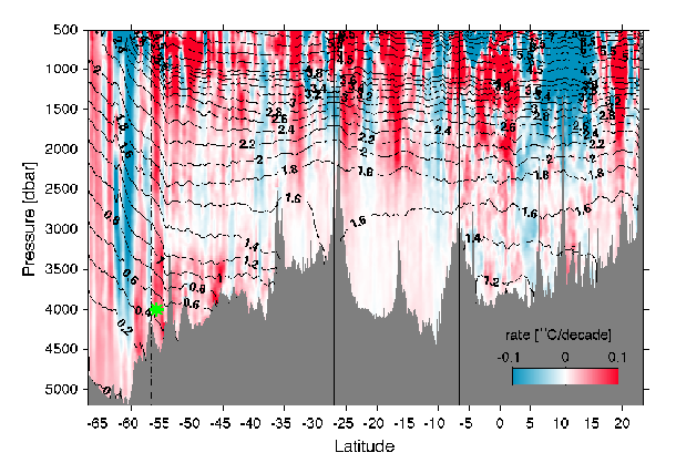
Fig. 4. Time rate of change of potential temperature dθ/dt (color bar), along the trackline of P18 (see Fig. 1 for location). Areas of warming are shaded in red, and regions of cooling are shaded in blue with intensity scaled by the magnitude of the change. Mean θ values over all occupations are contoured (black lines). This trackline is grouped into four basins for analysis (boundaries shown by vertical black lines), and the area south of the SAF (vertical dotted–dashed line) is also analyzed separately. The basins from south to north are the Amundsen–Bellingshausen Basin, Chile Basin, Peru Basin, and central Pacific Basin. Green asterisk denotes location of data used in Fig. 3.
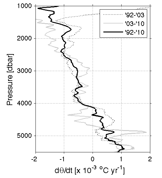
Fig. 5. Mean time rate of change in potential temperature dθ/dt at each pressure along the portion of P06 crossing the southwest Pacific basin (Fig. 1) calculated using every combination of pairs of the three occupations of P06 (see legend).
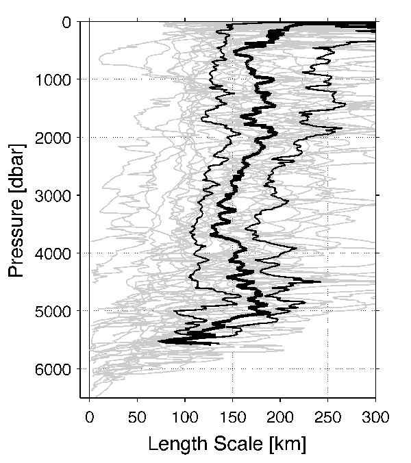
Fig. 6. Horizontal decorrelation length scales (km) of dθ/dt for each of the 28 repeat sections (gray lines) calculated at each pressure. The median (thick black line) and quartiles (thin black lines) are calculated from all sections with horizontal lengths greater than 2000 km at a given pressure. The pressure-averaged mean and median of the median length scale from 500 to 5000 dbar is 163 km.
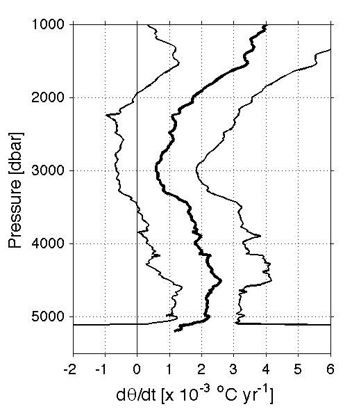
Fig. 7. Mean (thick black line) and 95% confidence limits (thin black lines) of dθ/dt for the Amundsen–Bellingshausen Basin calculated as described in the text, a length-weighted combination of the portions of repeated sections that cross the basin (in this instance P18 and P16, see Fig. 1 for locations).
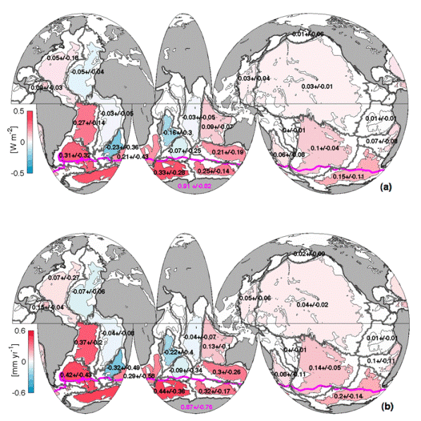
Fig. 8. (a) Mean local heat fluxes through 4000 m implied by abyssal warming below 4000 m from the 1990s to the 2000s within each of the 24 sampled basins (black numbers and color bar) with 95% confidence intervals. The local contribution to the heat flux through 1000 m south of the SAF (magenta line) implied by deep Southern Ocean warming from 1000 to 4000 m is also given (magenta number) with its 95% confidence interval. (b) Similarly, basin means of sea level rise from the 1990s to the 2000s due to abyssal thermal expansion below 4000 m and deep thermal expansion in the Southern Ocean from 1000 to 4000 m south of the SAF. Basin boundaries (thick gray lines) and 4000-m isobath (thin black lines) are also shown.
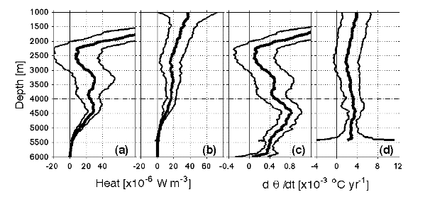
Fig. 9. Profiles of heat gain per meter (thick lines) with 95% confidence intervals (thin lines) estimated as described in (3) for the (a) global ocean and (b) Southern Ocean south of the SAF. Area-weighted mean profiles of dθ/dt for (c) the global ocean and (d) the Southern Ocean south of the SAF.
Return to References
Return to Abstract