Decadal temperature fluctuations in the Pacific Ocean have a significant
effect on marine ecosystems and the climate of North America. The physical
mechanisms
responsible for these fluctuations are poorly understood. Some theories ascribe
a central role to the wind-driven meridional overturning circulation between
the tropical and subtropical oceans. Here we show, from observations over the
past 50 years, that this overturning circulation has been slowing down since
the 1970s, causing a decrease in upwelling of about 25% in an equatorial strip
between 9°N and 9°S. This reduction in equatorial upwelling of relatively
cool water, from 47 × 10![]() to
35 × 10
to
35 × 10![]() m
m![]() s
s![]() ,
is associated with a rise in equatorial sea surface temperatures of about 0.8°C.
Another effect of the slowing circulation is a reduction in the outgassing
of CO
,
is associated with a rise in equatorial sea surface temperatures of about 0.8°C.
Another effect of the slowing circulation is a reduction in the outgassing
of CO![]() from the
equatorial Pacific Ocean—at present the largest oceanic source of carbon
dioxide to the atmosphere.
from the
equatorial Pacific Ocean—at present the largest oceanic source of carbon
dioxide to the atmosphere.
Recent analyses of historical data have revealed the signatures of decadal-timescale variations in the ocean-atmosphere system of the Pacific basin. These variations have been characterized in terms of cyclic oscillations over a broad band of frequencies with periods between 10 and 70 years (Minobe, 2000). Alternatively, they have been described in terms of regime shifts—abrupt and coherent changes in climatological conditions affecting large areas of the Pacific basin—the most pronounced of which in the past 50 years occurred in 1976–77 (Trenberth and Hurrell, 1994). One representation of this decadal variability, the so-called Pacific Decadal Oscillation (PDO), has a spatial structure very similar to that of the El Niño/Southern Oscillation (ENSO), which fluctuates between warm (El Niño) and cold (La Niña) phases at shorter periods of 3–7 years (Mantua et al., 1997; Zhang et al., 1997). Like ENSO, decadal-timescale temperature fluctuations in the Pacific have substantial effects on marine ecosystems and the climate of North America (Hare and Mantua, 2000; Cayan et al., 2001). The dynamics of decadal fluctuations are much less well understood than those of ENSO, however, and there is considerable debate about the underlying physical processes that govern them, especially in the ocean (Miller and Schneider, 2000). Some theories invoke mid-latitude ocean-atmosphere interactions originating in the North Pacific Ocean (Latif and Barnett, 1996), while others point to the importance of ocean-atmosphere interactions spanning tropical and subtropical latitudes (Lindsey et al., 2001; Garreaud and Battisti, 1999; Gu and Philander, 1997).
One of the most prominent theories for Pacific decadal climate variability (Gu and Philander, 1997) assumes that the meridional overturning circulation in the upper ocean acts as a conveyor belt for transporting water mass anomalies from the subtropics to the tropics. In this theory, air-sea interactions in the subtropics create surface water masses with unusually warm or cold temperatures that are subducted—that is, pushed downward—into the pycnocline (where the water density increases rapidly with depth). The temperature-tagged waters slowly drift equatorward below the surface for roughly 10 years, during which time they are isolated from further interaction with atmosphere. When these waters reach equatorial latitudes, they are upwelled to the surface where they are presumed to affect equatorial sea surface temperatures, air-sea heat exchange, and overlying atmospheric circulation in a manner similar to what happens during ENSO events. The upwelled water then flows back towards the subtropics in the surface layer to complete one circuit of the meridional circulation cell.
But recent evidence suggests that temperature anomalies subducted into the
pycnocline at subtropical latitudes may not reach the Equator with any appreciable
amplitude (Schneider
et al., 1999a). Model studies have indicated that these anomalies
can be either strongly dissipated, disperse in the form of planetary-scale
oceanic
waves, or become obscured by wind-forced variations at low latitudes (Schneider
et al., 1999b; Liu
and Shin, 1999; Nonaka
et al., 2000). Thus, a related hypothesis for the role of the meridional
overturning circulation in decadal-timescale climate variability has been proposed:
the circulation speeds up or slows down, transporting water masses with relatively
constant properties at faster or slower rates towards the Equator (Kleeman
et al., 1999). A dynamically changing ocean circulation has significant
implications for equatorial upwelling—which affects not only tropical
Pacific sea surface temperatures, but also the exchange of CO![]() across
the air-sea interface and the supply of nutrients to the biologically productive
surface layer of the ocean.
across
the air-sea interface and the supply of nutrients to the biologically productive
surface layer of the ocean.
To address the question of whether the meridional overturning circulation in the upper Pacific may be changing on decadal timescales, we have analysed hydrographic data between 20°S and 50°N for the period 1950–99 in the depth range of the upper pycnocline (typically 50–400 m in the tropical and subtropical Pacific). We have also computed surface-layer Ekman transports using multidecade long wind products derived from empirical and atmospheric model-based analyses of available observations. Results of our analysis, and implications for climate variability, are described below.
To illustrate important features of the general circulation, and to set the
context for discussion of decadal variations in pycnocline flows, Fig.
1a shows
the 50-year mean geostrophic streamlines and horizontal velocity field on the
25.0 kg m![]() potential
density surface which is located in the middle of the upper pycnocline. This
density surface outcrops at the sea surface between about 30° and 40°N
in the Northern Hemisphere and south of 20°S (except in the far eastern
Pacific) in the Southern Hemisphere. Water subducted into the pycnocline along
these outcrop lines can make its way to the Equator by both interior and western-boundary
routes. Interior pathways are more circuitous in the Northern Hemisphere because
of the presence of a potential vorticity ridge along 9°–10°N
(associated with uplift of the pycnocline under the Intertropical Convergence
Zone), which tends to block the flow of waters between higher latitudes and
the Equator in the eastern and central Pacific (Johnson
and McPhaden, 1999). Based on our estimates of geostrophic velocity, transit
times to the Equator on this density surface are about 5–10 years, depending
on details of a water parcel's pathway and where it is subducted. Comparable
transit times and circulation pathways have been inferred from numerical model
simulations (Huang
and Liu, 1999), circulation theory (McPhaden and Fine,
1988)
and tracer distributions (Quay
et al., 1983; Fine
et al., 2001).
potential
density surface which is located in the middle of the upper pycnocline. This
density surface outcrops at the sea surface between about 30° and 40°N
in the Northern Hemisphere and south of 20°S (except in the far eastern
Pacific) in the Southern Hemisphere. Water subducted into the pycnocline along
these outcrop lines can make its way to the Equator by both interior and western-boundary
routes. Interior pathways are more circuitous in the Northern Hemisphere because
of the presence of a potential vorticity ridge along 9°–10°N
(associated with uplift of the pycnocline under the Intertropical Convergence
Zone), which tends to block the flow of waters between higher latitudes and
the Equator in the eastern and central Pacific (Johnson
and McPhaden, 1999). Based on our estimates of geostrophic velocity, transit
times to the Equator on this density surface are about 5–10 years, depending
on details of a water parcel's pathway and where it is subducted. Comparable
transit times and circulation pathways have been inferred from numerical model
simulations (Huang
and Liu, 1999), circulation theory (McPhaden and Fine,
1988)
and tracer distributions (Quay
et al., 1983; Fine
et al., 2001).
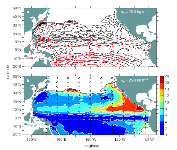
Figure 1. Mean circulation and potential vorticity averaged over 50
years (1950–99)
in the upper pycnocline of the Pacific Ocean. a, Geostrophic streamlines
relative to 900 dbar (in m![]() s
s![]() )
and b, absolute value of potential vorticity
(in 10
)
and b, absolute value of potential vorticity
(in 10![]() m
m![]() s
s![]() )
on the 25.0 kg m
)
on the 25.0 kg m![]() potential
density surface. Velocity vectors are overplotted on a. Distribution of hydrocasts
down to 900 dbar is overplotted on b, with the size of
the dots representing total number of casts in regions of 5° latitude
by 15° longitude (smallest, 50–300;
intermediate, 301–1,000;
largest, 1,001 or more). Winter season outcrop lines are drawn in both panels.
The outcrop lines define locations where wintertime surface mixing penetrates
deepest into the pycnocline, creating new water masses that are subsequently
sequestered from the atmosphere as seasonal heating restratifies the upper
ocean in spring and summer. Potential vorticity is defined as f(
potential
density surface. Velocity vectors are overplotted on a. Distribution of hydrocasts
down to 900 dbar is overplotted on b, with the size of
the dots representing total number of casts in regions of 5° latitude
by 15° longitude (smallest, 50–300;
intermediate, 301–1,000;
largest, 1,001 or more). Winter season outcrop lines are drawn in both panels.
The outcrop lines define locations where wintertime surface mixing penetrates
deepest into the pycnocline, creating new water masses that are subsequently
sequestered from the atmosphere as seasonal heating restratifies the upper
ocean in spring and summer. Potential vorticity is defined as f(![]()
![]() /
/![]() z)/
z)/![]()
![]() ,
where f is the Coriolis parameter,
,
where f is the Coriolis parameter, ![]()
![]() /
/![]() z
is the vertical density gradient, and
z
is the vertical density gradient, and ![]()
![]() is
a constant reference density (10
is
a constant reference density (10![]() kg
m
kg
m![]() ).
Water parcels conserve
their potential vorticity in an ideal fluid.
).
Water parcels conserve
their potential vorticity in an ideal fluid.
The flow pattern shown in Fig. 1a is similar
to that on isopycnals between about 22 and 26 kg m![]() in
the Northern Hemisphere and on isopycnals between 22.5 and 26.2 kg m
in
the Northern Hemisphere and on isopycnals between 22.5 and 26.2 kg m![]() in
the Southern Hemisphere. Waters less dense than 22.0 kg m
in
the Southern Hemisphere. Waters less dense than 22.0 kg m![]() almost
always fall within the surface mixed layer in the tropics, while interior flow
on density surfaces deeper than 26.2 kg m
almost
always fall within the surface mixed layer in the tropics, while interior flow
on density surfaces deeper than 26.2 kg m![]() is
weakly poleward near the Equator (Johnson and McPhaden,
1999). Thus, for the purpose of this analysis, we define
interior pycnocline transports associated with the shallow meridional overturning
circulation as occurring within the above range of density classes.
is
weakly poleward near the Equator (Johnson and McPhaden,
1999). Thus, for the purpose of this analysis, we define
interior pycnocline transports associated with the shallow meridional overturning
circulation as occurring within the above range of density classes.
We calculate pycnocline transports by integrating equatorward flows along 9°N and 9°S from the eastern boundary to near the western boundary. We choose 9°N because it represents a choke point for meridional geostrophic transports in the interior ocean. No similar constriction is present south of the Equator, so we integrate along 9°S for hemispheric symmetry. To test for continuity with meridional transports from higher latitudes, we repeated these calculations at 15°N and 15°S, which approximate the boundaries separating the subtropical and tropical gyres in terms of the depth-integrated horizontal mass transport streamfunction (Sverdrup, 1947).
We calculated meridional mass transports for 7–10 year periods in such
a way as to span the 1976–77 regime shift, and to maximize utilization
of the data that are not uniformly distributed in time. As expected from previous
work (Johnson
and McPhaden, 1999), transports are higher in the Southern Hemisphere than
in the Northern Hemisphere where flow between the subtropics and tropics is
more obstructed in the interior ocean (Fig. 2a).
However, we find that these transports have been non-stationary, with comparable
decreases of 6–7
sverdrups (1 Sv = 10![]() m
m![]() s
s![]() )
across both 9°N and 9°S since the 1970s.
)
across both 9°N and 9°S since the 1970s.
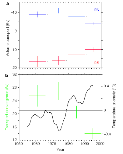
Figure 2. Meridional transports in the pycnocline and smoothed sea surface
temperatures over the past 50 years. a, Mean zonally integrated meridional
transports in the pycnocline relative to 900 dbar along 9°N and 9°S,
computed for 1956–65, 1970–77, 1980–89 and 1990–99. Values
are integrated in the Northern Hemisphere from the eastern boundary to 145°E
in density classes between 22 and 26 kg m![]() ,
and in the Southern Hemisphere from the eastern boundary to 160°E in density
classes between 22.5 and 26.2 kg m
,
and in the Southern Hemisphere from the eastern boundary to 160°E in density
classes between 22.5 and 26.2 kg m![]() .
Transports are in units of sverdrups (1 Sv = 10
.
Transports are in units of sverdrups (1 Sv = 10![]() m
m![]() s
s![]() )
which is the volumetric equivalent of mass for a constant reference density.
Error bars
are for one standard error. b, Mean meridional transport convergence
(in Sv) in the pycnocline across 9°N and 9°S. Convergence is calculated
as the difference
between Southern Hemisphere minus Northern Hemisphere transports in a.
Also plotted in b are areally averaged sea surface temperature anomalies
in the eastern and central equatorial Pacific (9°N–9°S, 90°W–180°W)
where equatorial upwelling is most intense (Wyrtki,
1981). The temperature
time series is derived from monthly analyses (Smith
et al., 1994) smoothed
twice with a 5-year running
mean
to filter out the seasonal cycle and year-to-year oscillations associated
with ENSO. Anomalies are relative to 1950–99 averages.
)
which is the volumetric equivalent of mass for a constant reference density.
Error bars
are for one standard error. b, Mean meridional transport convergence
(in Sv) in the pycnocline across 9°N and 9°S. Convergence is calculated
as the difference
between Southern Hemisphere minus Northern Hemisphere transports in a.
Also plotted in b are areally averaged sea surface temperature anomalies
in the eastern and central equatorial Pacific (9°N–9°S, 90°W–180°W)
where equatorial upwelling is most intense (Wyrtki,
1981). The temperature
time series is derived from monthly analyses (Smith
et al., 1994) smoothed
twice with a 5-year running
mean
to filter out the seasonal cycle and year-to-year oscillations associated
with ENSO. Anomalies are relative to 1950–99 averages.
The combined equatorward transport (or convergence) of pycnocline water across
9°N and 9°S drops from 27.0 ± 2.5 Sv before the regime shift
in the 1970s to 14.0 ± 1.5 Sv in the 1990s (Table
1). For comparison, meridional
transport convergences decrease from 38.0 ± 1.8 Sv in the 1970s to 29.5 ± 1.9
Sv in the 1990s across 15°N and 15°S in the same density classes.
Larger absolute transports are expected at 15°N and 15°S because
some of the interior ocean transport crossing the gyre boundaries is eventually
shunted into equatorward-flowing western boundary currents. However, the downward
trend is similar in magnitude to that observed across 9°N and 9°S,
and is likewise the result of approximately equal decreases in Northern and
Southern Hemisphere transports. Differences in the downward trend (8.5 Sv across
15° versus 13 Sv across 9°) may in part be due to the fact that some
of the very lightest waters between 22 and 23 kg m![]() are
formed equatorward of 15°N and 15°S. Decadal changes in western boundary
current transports between 9° and 15° may also account for some of
the difference, though (as will be shown below) changes in these transports
of only a few sverdrups are not detectable with confidence from our analysis.
are
formed equatorward of 15°N and 15°S. Decadal changes in western boundary
current transports between 9° and 15° may also account for some of
the difference, though (as will be shown below) changes in these transports
of only a few sverdrups are not detectable with confidence from our analysis.

The period from the 1970s to the 1990s coincides with a rise in sea surface temperatures of about 0.8°C in the equatorial Pacific (Zhang et al., 1997) (Fig. 2b). This temperature increase cannot be explained by an increase in surface heating. On the contrary, heat fluxes into the ocean have decreased over the past 50 years in the equatorial Pacific, primarily owing to an increase in cloudiness that has reduced the amount of sunlight reaching the surface (Liu and Huang, 2000). Thus, as occurs on ENSO timescales, changes in surface heat flux act to damp rather than to generate decadal changes in equatorial sea surface temperatures.
What accounts for the observed decadal decreases in interior ocean geostrophic transports, and are they related to the increases in sea surface temperature? Comparing the periods 1970–77 and 1990–99, we see that associated with the increase in sea surface temperature there is a decrease in the intensity of the easterly trade winds, as indicated by the prevalence of persistent westerly wind stress anomalies in the central and western Pacific (Fig. 3a). These features are the tropical manifestation of the PDO in its 'high' phase (warm tropics, cold central North Pacific) (Mantua et al., 1997; Zhang et al., 1997). Weaker surface easterlies in the 1990s are accompanied by increased surface wind convergence, atmospheric deep convection, and rainfall in the central equatorial Pacific, similar to what occurs during El Niño events (Wallace et al., 1998).
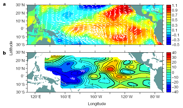
Figure 3. Decadal differences in the tropical Pacific between 1990–99
and 1970–77. a, Wind stress difference (in N m![]() )
for 1990–99
minus 1970–77, based on the Florida State University wind product (Goldenberg
and O'Brien, 1981).
Overplotted is the difference in sea surface temperature (in °C) the same
time period (Smith
et al., 1994). b, Depth difference (in m) of the 25.0
kg
m
)
for 1990–99
minus 1970–77, based on the Florida State University wind product (Goldenberg
and O'Brien, 1981).
Overplotted is the difference in sea surface temperature (in °C) the same
time period (Smith
et al., 1994). b, Depth difference (in m) of the 25.0
kg
m![]() potential
density
surface
for 1990–99 minus 1970–77.
potential
density
surface
for 1990–99 minus 1970–77.
The pycnocline normally slopes down to the west near the Equator, under the
influence of easterly trade wind forcing. This pycnocline slope induces a geostrophically
balanced meridional inflow towards the Equator in both hemispheres. The pattern
of wind stress differences in Fig. 3a favours
a relaxation of this pycnocline tilt, with anomalous deepening in the east
and shoaling in the west. Consistent
with this expectation, the depth of the pycnocline (as indicated by 25.0 kg
m![]() surface)
becomes shallower by about 10–30 m west of 160°W and deeper by about
10–30 m between 120°–150°W in the 1990s relative to the 1970s
(Fig. 3b). As a consequence, equatorward geostrophic
transport is reduced in both hemispheres in the 1990s, in accordance with ocean
circulation theory
that predicts less interior pycnocline exchange for anomalous westerly winds
near the Equator (McCreary
and Lu, 1994).
surface)
becomes shallower by about 10–30 m west of 160°W and deeper by about
10–30 m between 120°–150°W in the 1990s relative to the 1970s
(Fig. 3b). As a consequence, equatorward geostrophic
transport is reduced in both hemispheres in the 1990s, in accordance with ocean
circulation theory
that predicts less interior pycnocline exchange for anomalous westerly winds
near the Equator (McCreary
and Lu, 1994).
We expect that reduced meridional convergence in pycnocline transports should
be associated with reduced poleward transport of water in the surface layer.
To test this hypothesis, we computed meridional Ekman transports integrated
from the eastern boundary to the western boundary of the Pacific for four
different wind stress products that span at least two decades. Meridional Ekman
transport per unit longitude is given by the expression M![]() =
-
=
-![]()
![]()
![]()
![]() f ,
where
f ,
where ![]()
![]() is
the zonal component of the wind stress, f is the Coriolis parameter
(twice the local vertical component of the Earth's angular velocity), and
is
the zonal component of the wind stress, f is the Coriolis parameter
(twice the local vertical component of the Earth's angular velocity), and ![]()
![]() is
a constant reference density (10
is
a constant reference density (10![]() kg
m
kg
m![]() ).
These transports are confined approximately to the upper 50 m in the tropical
oceans (Ralph
and Niiler, 1999),
and are to the right of the wind stress in the Northern Hemisphere and to the
left
of
the
wind stress
in the Southern Hemisphere.
).
These transports are confined approximately to the upper 50 m in the tropical
oceans (Ralph
and Niiler, 1999),
and are to the right of the wind stress in the Northern Hemisphere and to the
left
of
the
wind stress
in the Southern Hemisphere.
Most wind stress products individually show decreases in zonally integrated
Ekman transports in the tropical Pacific associated with the broad-scale
weakening of the trade winds between the 1970s and 1990s. However, to reduce
the effects of uncertainties in individual products, and because no product
is unambiguously superior, we computed ensemble means of Ekman transports and
transport divergences from the four products for the same periods as for the
meridional pycnocline transports in Fig. 2.
Ensemble means and standard errors for the Ekman transport divergences across
9°N and 9°S, computed
as ![]() [M
[M![]() (9°N)
-M
(9°N)
-M![]() (9°S)]dx,
are 53.9 ± 5.3 Sv (1956–65), 58.4 ± 4.2 Sv (1970–77),
52.9 ± 4.5 Sv (1980–89) and 45.9 ± 5.5 Sv (1990–99). The
Ekman transport divergence is highest during 1970–77 and lowest during
1990–99,
decreasing by about 12 Sv over this time. This decrease is comparable to our
estimated decrease in interior pycnocline transport convergence.
(9°S)]dx,
are 53.9 ± 5.3 Sv (1956–65), 58.4 ± 4.2 Sv (1970–77),
52.9 ± 4.5 Sv (1980–89) and 45.9 ± 5.5 Sv (1990–99). The
Ekman transport divergence is highest during 1970–77 and lowest during
1990–99,
decreasing by about 12 Sv over this time. This decrease is comparable to our
estimated decrease in interior pycnocline transport convergence.
The difference between surface-layer transport divergence and pycnocline transport convergence across 9°N and 9°S should reflect flow in the western boundary currents (specifically, in the equatorward-flowing Mindanao Current across 9°N, and in the New Guinea Coastal Current and Undercurrent across 9°S). Inferred western boundary current transport convergences, estimated as the residual of a mass balance for each decadal period, are typically around 25 Sv (Table 1). Several more sverdrups at minimum should be added to these convergences, as western boundary currents (and the Mindanao Current in particular) supply upper pycnocline waters to feed much of the flow that exits the Pacific basin into the Indian Ocean through the Indonesian straits (Gordon et al., 1999). It is noteworthy, though, that these western boundary transport convergences, whose magnitudes are broadly consistent with those from modelling and observational studies (Johnson and McPhaden, 1999; Huang and Liu, 1999), do not seem to vary significantly on decadal timescales given the confidence limits of our estimates. Thus, if changes in western boundary current transports have occurred over the past several decades, they are likely to have been smaller than those for interior ocean geostrophic transports and surface-layer Ekman transports.
A complementary perspective on decadal variations in ocean pycnocline transports is available from Sverdrup theory (Sverdrup, 1947), the dynamics of which are fundamental to our understanding of large-scale oceanic circulation. This theory assumes that flow away from western boundaries is linear and in steady-state balance with surface wind stress forcing. The steady-state assumption is valid for the tropical oceans on decadal timescales, as the adjustment time in response to transient wind forcing at low latitudes is on the order of a few years (Philander, 1979).
Geostrophic transport per unit longitude based on Sverdrup theory is given
by Mg = (![]()
![]()
![]() )
)![]() [
[![]() ×
× ![]() +
+
![]()
![]() x/f],
where
x/f],
where ![]() is wind
stress vector and
is wind
stress vector and ![]() is
the change in the Coriolis parameter with latitude (McPhaden
and Fine, 1988).Using
this expression, we computed meridional transport convergences, integrated
from the eastern boundary to just outside the western boundary along 9°N
and 9°S, for each wind stress product. Resultant ensemble averages and
standard errors are 24.2 ± 2.6 Sv (1956–65), 27.1 ± 6.8 Sv (1970–77),
22.3 ± 4.9 Sv (1980–89) and 10.5 ± 4.1 Sv (1990–99). These
estimates are comparable in magnitude to pycnocline transport convergences
computed independently
from
hydrographic data, and exhibit a similar downward trend from the 1970s to the
1990s (Table 1).
is
the change in the Coriolis parameter with latitude (McPhaden
and Fine, 1988).Using
this expression, we computed meridional transport convergences, integrated
from the eastern boundary to just outside the western boundary along 9°N
and 9°S, for each wind stress product. Resultant ensemble averages and
standard errors are 24.2 ± 2.6 Sv (1956–65), 27.1 ± 6.8 Sv (1970–77),
22.3 ± 4.9 Sv (1980–89) and 10.5 ± 4.1 Sv (1990–99). These
estimates are comparable in magnitude to pycnocline transport convergences
computed independently
from
hydrographic data, and exhibit a similar downward trend from the 1970s to the
1990s (Table 1).
Sverdrup theory provides no information about the vertical structures of geostrophic currents, so that exact comparison with observations would require integration of measured geostrophic flow over the entire water column. It is possible therefore that the good agreement between observed pycnocline transports and geostrophic transports predicted from Sverdrup theory may be fortuitous. However, the circulation in the tropical Pacific is most vigorous in the upper ocean (Johnson et al., 2001), which leads us to conclude that the trend towards a weaker meridional overturning circulation from the 1970s to the 1990s is real.
Poleward flow in the surface Ekman layer extends to depths of about 50 m, whereas the pycnocline flows that we have identified extend to depths of hundreds of metres. The meridional overturning circulation is closed at low latitudes by upwelling, which brings cold pycnocline water to the surface where it once again makes contact with the atmosphere. Most of the upwelling transport (90% or more) in the tropical Pacific occurs along the Equator in the eastern and central basin, with smaller amounts in the Costa Rica dome (centred near 10°N, 90°W) and in the coastal upwelling regime off Peru (Chavez and Toggweiler, 1995). Most of the upwelled water is of extratropical origin, although a portion is associated with shallow meridional recirculation cells confined to within a few degrees of the Equator (McCreary and Lu, 1994; Johnson et al., 2001). Some water upwelled near the Equator downwells around 3°–4°N and 3°–4°S, returning to the Equator at the base of the surface layer. These surface-layer recirculating transports are averaged out of our estimates, which are representative of the deeper water masses of subtropical origin flowing across 9°N and 9°S.
From mass continuity, we can infer that upwelling has transported pycnocline water toward the surface between 9°N and 9°S at an average rate of about 40 Sv over the past several decades. The magnitude of this transport corresponds well with previous estimates, although different latitude and longitude ranges for the various computations preclude exact comparison (Quay et al., 1983; Wyrtki, 1981; Meinen et al., 2001). Our results also indicate that these upwelling transports have varied decadally, decreasing by about 25% from 47 Sv in the 1970s to 35 Sv in the 1990s (Table 1). The reduction in upwelling is consistent with inferences from radiocarbon data of a decreased supply of pycnocline water to the surface layer in the eastern and central equatorial Pacific since the 1970s (Guilderson and Schrag, 1998).
The picture that emerges from this analysis is that the wind-driven meridional overturning circulation in the upper Pacific has been slowing down since the 1970s. This slowdown can account for the recent anomalous surface warming in the tropical Pacific, as the supply of cold pycnocline water originating at higher latitudes to feed equatorial upwelling has decreased. The Southern Hemisphere is responsible for about half of the observed decrease in equatorward pycnocline transport. Thus, perspectives on decadal variability limited to the Northern Hemisphere alone are incomplete. The fact that few studies have considered a role for the Southern Hemisphere ocean is presumably a consequence of limited data availability rather than a lack of decadal signal in the southern tropics and subtropics (Chang et al., 2001).
The oceanic and atmospheric processes that we have described work together so as to reinforce each other, similar to the positive feedbacks that occur during ENSO events. For example, weaker easterly trade winds in the equatorial Pacific would result in reduced Ekman and geostrophic meridional transports, reduced equatorial upwelling, and warmer equatorial sea surface temperatures. Warmer surface temperatures in turn would alter patterns of deep atmospheric convection so as to favour weaker trade winds. If the system is to oscillate on decadal timescales, then delayed negative feedback mechanisms, one candidate for which involves planetary-scale ocean waves, must also be important (Zhang et al., 1997; Kleeman et al., 1999; Knutsen and Manabe, 1998).
Similarities in the spatial structures of the PDO and ENSO (both, for example, have phases that are characterized by warm tropics and a cool central North Pacific, and vice versa) have raised questions about the possible interaction between interannual- and decadal-timescale phenomena in the Pacific. In particular, since 1976–77 there have been fewer La Niña events, and more frequent, stronger, and longer-lasting El Niño events.Whether this recent change in the character of the ENSO cycle is a consequence or a cause of underlying decadal-timescale variability is unknown. It could be that the decadal changes in circulation described here operate independently from those that affect the ENSO cycle. If so, they would modify the background state on which ENSO develops, and thereby precondition interannual fluctuations to preferred modes of behaviour (Federov and Philander, 2000; Urban et al., 2000). Alternatively, the observed decadal changes may simply be the low-frequency residual of random or chaotic fluctuations in tropical ocean-atmosphere interactions that give rise to the ENSO cycle itself (Kirtman and Schofp, 1998). In either case, a complete understanding of climate variability spanning interannual to decadal timescales in the Pacific basin will need to account for the slowly varying meridional overturning circulation between the tropics and subtropics.
Results of some numerical coupled ocean-atmosphere model studies suggest that the response of the tropical Pacific to greenhouse-gas forcing resembles a permanent El Niño-like condition (Knutsen and Manabe, 1998; Meehl and Washington, 1995). Thus, it is conceivable that climate fluctuations in the tropical Pacific over the past 50 years, including the recent slowdown of the meridional overturning circulation, may have been influenced by global warming as well as by natural variability. Unfortunately, separating out the putative effects of anthropogenically forced climate change from natural variations is not possible with relatively short data records. Our analysis can, however, provide an important dynamical constraint for model studies that attempt to simulate recent observed decadal changes in the Pacific basin.
Finally, we note that the equatorial Pacific is the largest oceanic source
of CO![]() to
the atmosphere (Feely
et al., 1999; Feely
et al., 2002). It also accounts
for roughly 20% of the photosynthetically mediated new biological production
in
the world's
oceans (Chavez
and Toggweiler, 1995).
Upwelling of nutrient-
and carbon-rich water to the sea surface is the principal reason why the equatorial
Pacific is so important in global biogeochemical cycles. Consistent with
a decrease in upwelling in the 1990s relative to earlier decades, the outgassing
of CO
to
the atmosphere (Feely
et al., 1999; Feely
et al., 2002). It also accounts
for roughly 20% of the photosynthetically mediated new biological production
in
the world's
oceans (Chavez
and Toggweiler, 1995).
Upwelling of nutrient-
and carbon-rich water to the sea surface is the principal reason why the equatorial
Pacific is so important in global biogeochemical cycles. Consistent with
a decrease in upwelling in the 1990s relative to earlier decades, the outgassing
of CO![]() from
the equatorial Pacific Ocean has decreased from the 1980s
to the 1990s (Feely
et al., 1999; Feely
et al., 2002), potentially reducing
the rate at which CO
from
the equatorial Pacific Ocean has decreased from the 1980s
to the 1990s (Feely
et al., 1999; Feely
et al., 2002), potentially reducing
the rate at which CO![]() would
otherwise have accumulated in the atmosphere (Feely
et al., 2002). It
is also
likely
(though
difficult
to confirm for lack of adequate data) that the supply of nutrients to
the surface layer of the equatorial Pacific has decreased from the 1970s
to the 1990s. A reduced nutrient supply would favour a reduction in biological
productivity in the equatorial Pacific, which in turn would affect overall
global rates of carbon fixation.
would
otherwise have accumulated in the atmosphere (Feely
et al., 2002). It
is also
likely
(though
difficult
to confirm for lack of adequate data) that the supply of nutrients to
the surface layer of the equatorial Pacific has decreased from the 1970s
to the 1990s. A reduced nutrient supply would favour a reduction in biological
productivity in the equatorial Pacific, which in turn would affect overall
global rates of carbon fixation.
Processing of hydrographic data
Hydrographic data were obtained from theWorld Ocean Data Base (Conkright
et al., 1999) augmented with data from archives of the Pacific
Marine Environmental Laboratory (Johnson
and McPhaden, 1999). A total of 114,691 casts between
20°S and 50°N reach 900 dbar (1 dbar = 0.992 m
depth), which is the reference level of our geostrophic velocity estimates.
The number of casts for defining water mass properties on shallow density
surfaces is greater (for example, 215, 993 casts on the 25.0 kg m![]() isopycnal shown in Fig. 1). By decade, the number
of casts to 900 dbar is 11,584 (1950–59),
21,779 (1960–69), 24,920 (1970–79), 36,110 (1980–89) and
20,298 (1990–99).
isopycnal shown in Fig. 1). By decade, the number
of casts to 900 dbar is 11,584 (1950–59),
21,779 (1960–69), 24,920 (1970–79), 36,110 (1980–89) and
20,298 (1990–99).
Data coverage is relatively sparse in the Southern Hemisphere, which limits our analysis to latitudes north of 20°S. Data are also unevenly distributed spatially and temporally, potentially aliasing interannual, seasonal and shorter timescale and space-scale fluctuations into the decadal climate signals in which we are interested. Despite these sampling limitations, the data are adequate to define robust features of the mean circulation and its large-scale variability averaged over periods of 7–10 years.
Data were binned in boxes of 0.5° latitude by 0.5° longitude, then gridded objectively by decade on density surfaces. We assumed a gaussian correlation structure function with a half-width of 5° latitude by 15° longitude in the interior ocean, and 5° latitude by 5° longitude near the western boundary. The distribution of hydrocast data on the larger of these scales is shown in Fig. 1b. Our choice of 900 dbar as a reference level for geostrophic velocity computations is consistent with previous analyses in the tropical and subtropical Pacific (Johnson and McPhaden, 1999). This level represents a compromise between optimizing data coverage (which is better near to the surface) and capturing weak horizontal flows below 900 dbar. Choosing alternative reference depths (for example, 600 dbar or 1,200 dbar) leads to only minor differences in pycnocline transport values (0.5–1 Sv).
The zonal integral of interior ocean meridional geostrophic transport is effectively the difference between depth-integrated dynamic height at opposite ends of the basin. To estimate the random sampling error for these transports, we performed Monte Carlo simulations on subsets of data near the eastern and western limits of the basin for each decadal period. Typically hundreds of data pairs were available for these assessments within several degrees of latitude and longitude around the end points of the transport calculation. Results are shown as one standard error in text, figures and tables.
Ekman and Sverdrup transports
We use four wind products to compute Ekman and Sverdrup transports: the Comprehensive Ocean Atmosphere Data Set (COADS) winds for 1950–93 (da Silva et al., 1994), the Florida State University (FSU) winds for 1961–99 (Goldenberg and O'Brien, 1981), the National Centers for Environmental Prediction (NCEP) winds for 1958–99 (Kalnay et al., 1996), and the European Centre for Medium Range Weather Forecasts (ECMWF) (ECMWF, 2001) winds for 1979–99. COADS provides a stress product directly; FSU, NCEP and ECMWF wind analyses were converted to wind stress using essentially the same algorithm as used in COADS. We required a minimum of 5 years in any given period to compute a decadal average.
There are shortcomings in these (and other) wind products in terms of potential systematic biases related to data coverage, analysis procedures, or both (Liu and Huang 2000; Hackert et al. 2001). Therefore, rather than rely on any one product alone, we formed ensemble means of the different products to draw out significant climate signals common to all. This procedure also provides a measure of the uncertainty (in the form of statistically derived standard errors) in our representation of those signals.
Data shown in Table 1
Interior ocean pycnocline transports relative to 900 dbar were derived from hydrographic data, and convergence was computed as the difference of 9°S minus 9°N values. Ekman transports were adjusted downward for measured equatorward geostrophic flows in the surface layer of the interior ocean, and divergence computed as the difference of 9°N minus 9°S. Western boundary current transport convergences represent the difference between surface-layer divergences and interior ocean pycnocline convergences, assuming that mass is conserved in the upper ocean. Upwelling transports between 9°N and 9°S were computed by assigning 80% of the western boundary current transport convergence to the pycnocline layer and 20% to the surface layer, based on observed mean vertical structures of these currents.
Western boundary current transport convergences in Table 1 represent lower bounds, because these currents also supply upper pycnocline water to the Indonesian throughflow (Gordon et al., 1999). However, those additional sverdrups of boundary current transport required to feed the throughflow, since they simply leave the basin, do not affect our equatorial upwelling computations. Moreover, we estimate that on decadal timescales the Indonesian throughflow has remained constant to within about ±1 Sv on the basis of calculations using Godfrey's island rule (Godfrey, 1989) forced by global NCEP (Kalnay et al., 1996) and ECMWF (ECMWF, 2001) wind fields. Coupled ocean-atmosphere model integrations indicate a similar range of possible decadal-timescale variations in Indonesian throughflow (Schneider, 1998). These fluctuations are much smaller than those associated with the meridional overturning circulation in the upper Pacific.
We thank J. Potemra for advice on Indonesian throughflow calculations. We also thank W. Kessler, G. Johnson and R. Kleeman for comments on an earlier version of this manuscript. This work was supported by the NOAA Office of Oceanic and Atmospheric Research and by the Joint Institute for the Study of the Atmosphere and Ocean (JISAO) at the University of Washington.
Return to Abstract or go to References