We begin with a brief overview of El Niño, which was the primary phenomenological focus of TOGA, in order to highlight physical principles that helped to guide development of the TOGA observing system. This overview parallels what was known at the start of TOGA with the caveat that, as a conceptual model, many of its key mechanisms were poorly understood or not yet critically tested from observations. Progress beyond this simple description is taken up in sections 3 and 4.
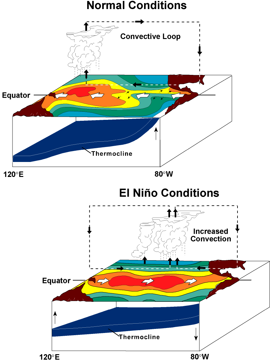
In the tropical Pacific, net heat gain from the atmosphere tends to create a warmer surface layer near the equator than at higher latitudes. Under normal conditions (Figure 1, top), easterly trade wind forcing drives near-equatorial surface flow westward in the South Equatorial Current (SEC), piling up this warm surface layer in the western Pacific to create a deep warm pool. Conversely, warm water is drained from the eastern Pacific, leading to an upward tilt of the thermocline to the east. The relative shallowness of the thermocline in the eastern Pacific increases the efficiency of local trade-wind-driven equatorial upwelling to cool the surface, creating a cold tongue in SST that extends from the coast of South America to near the international date line. The easterly trade winds are reinforced by the east-west SST contrast, which is associated with low atmospheric surface pressure over the warm pool in the west and high surface pressure over the cooler waters of the eastern Pacific. Atmospheric circulation on the equatorial plane (that is, the Walker circulation) is closed by ascent of warm moist air over the warm pool (associated with deep convection and precipitation), westerly winds aloft, and subsidence in the high-pressure zone of the eastern Pacific. In the ocean, westward flow in the surface SEC is in part compensated by a return flow to the east in the thermocline, i.e., the Equatorial Undercurrent (EUC). This current flows down the zonal pressure gradient associated with the east-west tilt of the thermocline and provides a source of water for upwelling in the east [Bryden and Brady, 1985].
Figure 1: Schematic of normal and El Niño conditions in the equatorial Pacific. See section 2 for discussion.
During El Niño (Figure 1, bottom), the trade winds weaken in the central and western Pacific, leading to a local eastward acceleration of the surface currents. In addition, weakening of the trade winds excites downwelling equatorial Kelvin waves, which propagate into the eastern equatorial Pacific, where they depress the thermocline, and upwelling equatorial Rossby waves, which propagate into the western Pacific, where they elevate the thermocline [Wyrtki, 1975; McCreary, 1976; Hurlburt et al., 1976]. Anomalously warm sea surface temperatures appear from the coast of South America to west of the international date line, and the pattern of deep convection and precipitation shifts eastward with the warmest SSTs [Gill and Rasmusson, 1983]. Deep convection is the principal driving force for atmospheric circulation through the release of latent heat at midtropospheric levels, and these shifts in the centers of deep convection during El Niño affect the atmospheric circulation on a global basis [Horel and Wallace, 1981].
The physical basis for ENSO and related phenomena provided a rationale for the development of an observing system to measure key oceanographic and meteorological variables. Prioritization of these variables was based on the need not only to better document and understand but also to predict short-term climate variability. Foremost were fields of surface wind stress and sea surface temperature since, as evident from discussion in the preceding section, it is these two variables by which the ocean and atmosphere most immediately interact in the tropics.
Of next highest priority was the upper ocean thermal field. The basic periodicity of ENSO is controlled in part by the vast thermal inertia of the upper ocean through the propagation of planetary-scale equatorial waves. These waves mediate coupling to the atmosphere on interannual timescales by redistributing upper ocean heat not only zonally along the equator, as evident in Figure 1, but also meridionally [Wyrtki, 1985a]. Thus the "memory" for the ENSO cycle is to be found in the ocean rather than in the atmosphere, where (excluding the mean seasonal cycle, which is externally forced by variations in insolation) intrinsic timescales are much shorter and are primarily associated with 3–5-day weather variability. Also, the slow evolution of upper ocean heat content on seasonal-to-interannual timescales suggested a logic for initializing ocean models used in climate prediction with subsurface temperature data.
Sea level variability was likewise deemed to be a crucial variable because it is a proxy for upper ocean heat content. The tropical oceans behave in many ways as a two-layer fluid, with thermocline variations reflected in sea level heights [Rebert et al., 1985]. For example, during ENSO, sea level is elevated when the thermocline deepens in the eastern Pacific, and it is depressed when the thermocline shoals in the western Pacific. Sea level thus provides a convenient measure of the vertically integrated oceanic response to atmospheric forcing.
Measurement of ocean currents was deemed to be essential for meeting the goals of TOGA because of the strong control ocean dynamics plays in creating ENSO SST anomalies. In most parts of the world ocean, seasonal-to-interannual changes in SST are controlled simply by variations in heat flux across the air-sea interface. In the equatorial Pacific, on the other hand, changes in three-dimensional ocean circulation play a crucial role in generating ENSO SST anomalies through horizontal advection and through changes in intensity of upwelling in the cold tongue region. To a certain extent, the need for information on the horizontal flow field could be met via estimates from the thermal field via geostrophy. However, it was also considered essential to directly measure horizontal currents along the equator, where pure geostrophy breaks down, and in the surface mixed layer, where frictional Ekman flows were expected to be large and likewise inaccessible via the geostrophic approximation.
Surface winds, SST, upper ocean thermal structure, sea level, and ocean currents, though of central importance in motivating the development of an observing system for TOGA, were of course not the only variables considered to be of value for studies of ENSO and related phenomena. It was appreciated that a quantitative understanding of SST variability required improved estimates of surface heat fluxes, that salinity variability needed to be better documented in the tropical oceans for a variety of reasons (e.g., its contribution to static stability and dynamic height, and its potential role in the surface heat balance in regions of heavy rainfall), and that studies of atmospheric circulation would benefit from an improved definition of precipitation (an integral measure of latent heat release) over the ocean. TOGA-sponsored research activities thus addressed measurement issues aimed at variables other than winds, SST, upper ocean thermal structure, sea level, and currents. However, these five key variables were viewed as a sine qua non both for improved understanding of short-term climate variability (section 3) and for the development of climate forecast models with significant predictive skill (section 4).
It was also recognized at the start of TOGA that, although ENSO is predominantly a large-scale, interannual perturbation of the climate system, it could not be effectively observed without taking into account smaller-scale, higher-frequency fluctuations. There is a broad spectrum of variability in both the ocean and the atmosphere that represents a potential source of geophysical noise in estimates of climate signals. Noise contamination can arise because of inadequate sampling in space and/or time, which will alias energy from high-frequency, small-scale fluctuations into the lower frequencies and larger scales of climatic interest. The existence of this broad spectrum of variability imposes stringent sampling requirements for climate observations. As an example, Halpern [1988a] and Mangum et al. [1992] determined that about one sample per day would be required at a given location in the equatorial Pacific to estimate monthly mean winds with an accuracy of 0.5–1.0 m s-1. Much of the equatorial Pacific was significantly undersampled relative to this criterion by volunteer observing ships (VOS), the main source of information on surface winds prior to and during the early stages of TOGA. Furthermore, some high-frequency variations were likely to be dynamically relevant in the evolution of El Niño. Potential scale interactions result from nonlinearities in the ocean-atmosphere system through processes such as atmospheric convection, ocean mixing, heat and momentum advection, etc. Considerable debate, for example, revolved around the role of episodic 1–10-day westerly wind bursts and the 30–60-day intraseasonal Madden and Julian Oscillation [Madden and Julian, 1971, 1972] in either triggering or sustaining El Niño events or in accounting for the irregular periodicity of El Niño [e.g., Keen, 1982; Luther et al., 1983; Harrison and Schopf, 1984; Lau and Chan, 1986].
Resolution and accuracy requirements established by TOGA for the measurements discussed in this study are presented in Table 1, as excerpted from the fourth edition of the "TOGA International Implementation Plan" [International TOGA Project Office, 1992]. These requirements evolved during the program as understanding of the climate system and technical capabilities improved. Table 1 represents the final assessment of the TOGA community, taking into account developments up to 1992. No specific requirements were set for subsurface temperature. For this variable it was felt that available observational techniques would fall short of expectations, especially in terms of resolution, except in certain well-sampled regions. Note that as a practical matter, surface wind velocity rather than wind stress is measured over the oceans, with stress estimated from wind velocity using bulk turbulent transfer formulae. As specified in Table 1, an accuracy of 0.01 Pa (1 Pa = 1 N m-2) for surface stress translates roughly into an accuracy requirement of 0.5 m s-1 for surface winds in regions of trade wind forcing.
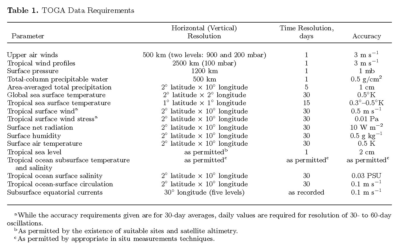
Table 1. TOGA Data Requirements
The requirements in Table 1 were generally cast in terms of mapping and/or documenting variability, rather than in terms of requirements for initialization of climate forecast models. These latter requirements are still a matter of ongoing research. Nonetheless, by the standards of Table 1, it could be claimed that by the end of TOGA the observing system met many of the data requirements in the equatorial Pacific Ocean between 8°N and 8°S. This is partly because that was where most in situ resources were concentrated and partly because TOGA data requirements in some instances (e.g., subsurface temperature and sea level) were based on what was considered technically feasible. Outside the latitude band 8°N–8°S in the tropical Pacific, and in the tropical Atlantic and Indian oceans, the observing system fell short of specific requirements in Table 1.
In the following subsection we provide a brief summary of the observing system, element by element. Additional technical details such as instrumental design and instrumental accuracies are elaborated on in Appendices B, C, and D.
In situ elements of the oceanographic observing system developed and implemented in support of TOGA objectives are illustrated in and summarized in Figures 2 and 3 and summarized in Tables 2 and 3. These elements include an island and coastal tide gauge network to provide sea level measurements; drifting buoy arrays to provide mixed layer velocity and SST measurements; the TOGA Tropical Atmosphere-Ocean (TAO) array of moored buoys to provide surface wind, SST, upper ocean temperature, and current measurements; and a volunteer observing ship (VOS) expendable bathythermograph (XBT) program for upper ocean temperature profiles. The XBT program was embedded in the ongoing program of VOS surface marine meteorological measurements, which provided wind, SST, and other surface data. TOGA also inherited a decade-long VOS sea surface salinity network in 1985. In addition, repeat hydrographic sections from regularly scheduled research cruises, most notably along 110°W [McPhaden and Hayes, 1990b; Hayes et al., 1991c], 165°E [Delcroix et al., 1992], and 137°E [Shuto, 1996], provided valuable information on upper ocean water mass structures in the Pacific during TOGA.
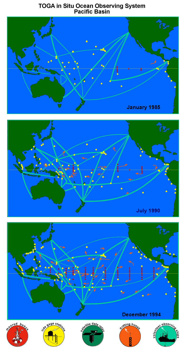
Figure 2: The in situ Tropical Pacific Ocean Observing System developed under the auspices of the TOGA program. (top) The observing system in January 1985 at the start of TOGA; (middle) the observing system in July 1990 at the time of the TOGA midlife conference in Honolulu [World Climate Research Program, 1990b]; (bottom) the observing system in December 1994 at the end of TOGA. The four major elements of this observing system are (1) a volunteer observing ship expendable bathythermograph program (shown by schematic ship tracks); (2) an island and coastal tide gauge network (circles); (3) a drifting buoy program (shown schematically by curved arrows); and (4) a moored buoy program consisting of wind and thermistor chain moorings (shown by diamonds) and current meter moorings (shown by squares). Thick ship tracks indicate expendable bathythermograph sampling with 11 or more transects per year; thin ship tracks indicate sampling with 6–10 transects per year. Although emphasis is on 30°N–30°S, termini of VOS XBT lines originating outside these limits are nonetheless shown. One drifting buoy schematic represents 10 actual drifters. Only those tide gauge stations are shown that reported their data to the TOGA Sea Level Center in Honolulu within 2 years of collection. Some tide gauge stations are so close as to be overplotted on one another. By December 1994 most measurements made as part of this four-element observing system were being reported in real time, with data relay via either geostationary or polar orbiting satellites.
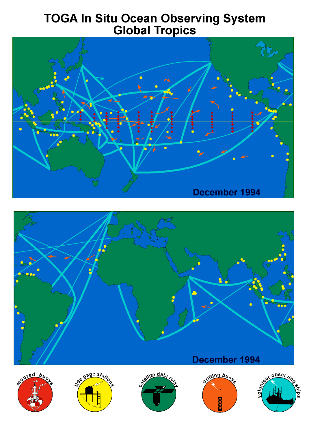
Figure 3: The in situ TOGA Ocean Observing System in its final configuration in December 1994. (top) Pacific Ocean, (bottom) Indian and Atlantic Oceans. Symbols are as in Figure 2.
Table 2. In Situ Elements of the TOGA Ocean Observing System
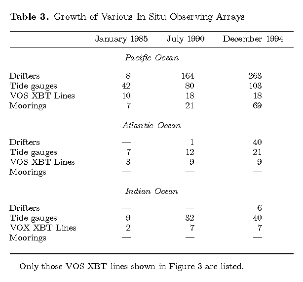
Table 3. Growth of Various In Situ Observing Arrays
A key feature of the array elements shown in Figures 2 and 3 was that by the end of TOGA most of the data were transmitted to shore via satellite relay in real time. In addition, each array element had unique measurement capabilities that were advantageous for TOGA (Table 2). However, none of these elements by themselves would have been adequate for TOGA purposes, because each has certain disadvantages in terms of cost and/or sampling characteristics that limit its applicability for short-term climate studies. These array components were therefore viewed as complementary to one another, providing a synergistic framework in which to document and analyze climate fluctuations in the tropical oceans.
Design of the observing system was guided by general circulation model simulations of wind-forced oceanic variability and by empirical studies of space-time correlation scales. Model design studies indicated, for example, that basin-scale wind measurements were required within at least ~7° of the equator to simulate accurately the seasonal-to-interannual evolution of SST variability in the cold tongue region of the equatorial Pacific, and that the ocean responds most sensitively to zonal wind rather than meridional wind forcing on these timescales [Harrison, 1989]. Empirical studies indicated that zonal wind field variations are minimally coherent over 2°–3° latitude and 10°–15° longitude [Harrison and Luther, 1990], and that approximately one sample per day would be required to meet TOGA accuracy requirements [Halpern, 1988a; Mangum et al., 1992]. The space scales and timescales of upper ocean thermal structure are depth dependent and nonstationary in time. However, the most stringent thermal field sampling requirements (for thermocline temperature during non-ENSO periods) are comparable to those for zonal winds [e.g., Meyers et al., 1991; Hayes and McPhaden, 1992; Kessler et al., 1996]. Scales of variability and sampling requirements for velocity were described in work by Hansen and Herman [1989], World Climate Research Program [1990b], and McPhaden et al. [1991].
Design of the observing system was constrained by logistical considerations, such as the availability of islands suitable for tide gauge installation and the availability of commercial shipping routes. It was also constrained by the practicalities of cost, since financial resources were limited. Implementation was based on existing technologies, although measurement capabilities and cost efficiencies were greatly enhanced by two significant technological breakthroughs. One was the development of a low-cost Autonomous Temperature Line Acquisition System (ATLAS) wind and thermistor chain mooring capable of telemetering its data in real time [Hayes et al., 1991a]. The second was the development of a low-cost, long-lived drifting buoy with accurate water-following characteristics [Niiler et al., 1995].
The in situ observing system was much better developed in the Pacific than in the Atlantic and Indian Oceans, as evident in Figure 3 and Table 3. In the Atlantic and Indian Oceans, fewer VOS XBT tracks and tide gauge stations were instrumented, and no long-term moorings were deployed for TOGA purposes. Drifter deployments were occasionally made in the tropical Atlantic and Indian Oceans during TOGA [e.g., Integrated Global Ocean Services System (IGOSS), 1992], but there was no program of sustained drifter deployments undertaken in either basin specifically by TOGA investigators until near the end of the program.
The full TAO array of ~70 moorings is situated between 8°N and 8°S, 95°W and 137°E and spans over one third the circumference of the globe at the equator (Figure 2). The backbone of the array is the low-cost ATLAS wind and thermistor chain mooring [Hayes et al., 1991a]. Five long-term current meter mooring sites are also maintained along the equator [World Climate Research Program, 1990a]. The array was built up primarily during the second half of TOGA (Figure 2 and Table 3) and was completed only at the very end of TOGA in December 1994 [McPhaden, 1995]. A major advantage of the TAO array was its finely resolved (daily or higher temporal resolution) time series data of key variables, particularly winds, which significantly reduced the amount of aliased high-frequency energy in the climate signals of interest. Data were transmitted in real time to shore via Service Argos then retransmitted on the Global Telecommunications System (GTS). Financial support was derived mainly from the United States, France, Japan, Taiwan, and Korea.
A TOGA/World Ocean Circulation Experiment (WOCE) Surface Velocity Program (SVP) was organized at the beginning of TOGA to seek broad international support for drifter acquisitions and deployments. At the time, there were several competing designs of unknown water-following characteristics. Several years of engineering and design work led to the Global Lagrangian Drifter with a mean lifetime (defined in terms of drogue retention) of roughly 300–400 days. Position information, SST, and other drifter data were telemetered to shore in real time via Service Argos then retransmitted on the GTS. In TOGA, drifters were deployed from research vessels, VOS, and airplanes. The objective was to maintain drifter arrays with enough samples in 2° latitude × 8° longitude areas to define the mean 15-m circulation, the seasonal cycle [Reverdin et al., 1994], and ENSO-related anomalies [Frankignoul et al., 1996]. SST data from the drifters have also proven to be critical for operational SST analyses (see Appendix C). By the end of TOGA, over 700 drifters were operational in the global oceans, over one third of which were deployed in the tropical Pacific. The SVP emerged from TOGA as the Global Drifter Program, maintained with resources from 16 countries.
TOGA inherited a substantial Pacific tide gauge network that was largely installed during NORPAX. Though design of the tide gauge network was constrained by the availability of islands where gauges could be placed (Figures 2 and 3), efforts in the Pacific during TOGA were focused on expanding and refining this network, under the direction of the University of Hawaii Sea Level Center. By the end of TOGA the number of stations in the Pacific had more than doubled (Table 3). Relative growth was equally impressive in the Atlantic and Indian Oceans, although the number of sites instrumented in those oceans was fewer than in the Pacific. Many sites were linked to the Hawaii Center via data channels on geostationary satellites. In addition, many of the TOGA tide gauges contributed to the Integrated Global Ocean Services System (IGOSS) Sea Level Project in the Pacific, for which data were made available via GTS with a delay of 1 month.
There are currently around 7000 VOS worldwide, operated by about 50 countries. They collect observations on sea surface pressure, wind velocity, sea state, humidity, and SST as part of the World Weather Watch (WWW). On a few routes, surface salinity is also sampled. Each month, typically 100,000 or more surface observations are collected and transmitted in real time to national meteorological centers via satellite communication systems or via coastal radio stations, then entered onto the GTS for general use. Prior to the establishment of TAO and other dedicated TOGA observing systems, data from VOS marine reports and from island weather stations constituted the bulk of the available information on seasonal and interannual variability in tropical surface marine meteorological fields. Important data sets and products such as the Florida State University (FSU) wind analysis [Stricherz et al., 1992] and Comprehensive Ocean-Atmosphere Data Set (COADS) [Woodruff et al., 1987] derive largely from VOS surface marine observations.
A subset of VOS ships also collect XBT data, and ~150,000 temperature profiles to a depth of 400 m or more were added to the climatological database during TOGA in the tropical Pacific. Design of the VOS XBT array for TOGA was based on a strategy of low-density sampling to provide broad-scale, widely dispersed coverage in areas of routine merchant shipping on a monthly-to-quarterly cycle for description of large-scale thermal field signals. Recommended low-density XBT sampling was prescribed as one XBT drop per 1.5° latitude by 7.5° longitude per month. TOGA also recognized a need to observe seasonal and interannual variations of major geostrophic currents in the tropical oceans. A strategy of frequently repeated sampling with higher along-track resolution was devised for a few transequatorial VOS lines to meet this need [Meyers et al., 1991]. On some routes, expendable conductivity-temperature-depth (XCTD) data were also collected [Roemmich et al., 1994]. By the end of TOGA most VOS XBT data were telemetered to shore in real time via Service Argos or via geostationary satellites, then retransmitted on the GTS.
Complementing in situ oceanographic observations were satellite missions to measure SST, sea level, and winds (Table 4). Sea level measurements were provided from altimeters flown on the Geosat mission, the ERS-1 mission, and the joint National Aeronautics and Space Administration (NASA)/Centre National d'Études Spatiales (CNES) TOPEX/POSEIDON mission. SST measurements were derived principally from multichannel advanced very high resolution radiometers (AVHRR) carried aboard the National Oceanic and Atmospheric Administration (NOAA) series of polar orbiting weather satellites. Wind speeds were measured by the special sensor microwave imager (SSM/I) deployed on the Defense Meteorological Satellite Program (DMSP) sponsored by the U.S. Department of Defense. Remotely sensed wind velocities were first available during TOGA beginning in 1991 from a scatterometer aboard the ERS-1 satellite. Note that Table 4 does not list all the wind speed and SST data available during TOGA from satellite platforms. For example, SST information was available from the along-track scanning radiometer on ERS-1, and wind speed was available from altimeter missions. The emphasis in Table 4 is on those satellite data sets which for technical reasons were most widely applied in TOGA studies.
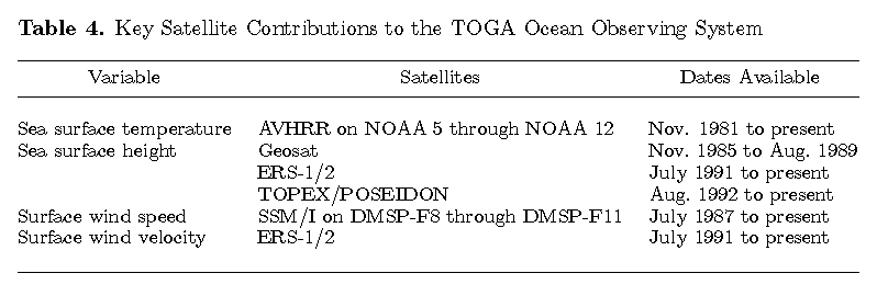
Table 4. Key Satellite Contributions to the TOGA Ocean Observing System
Satellite measurements have the advantage of being global, or nearly so, in coverage and quasi-synoptic in time, and they often have better spatial and/or temporal resolution than in situ data. The increased use of satellite data did not diminish the need for in situ oceanographic measurements, however. In situ techniques are required for measurements of variability below the surface of the ocean. Also, satellite systems rely on complicated algorithms to convert measurements of electromagnetic radiation into geophysically meaningful variables. To be useful, satellite data must be calibrated and validated against in situ observations in order to detect and remove potential biases induced by orbital errors, instrumental errors, and/or atmospheric effects (e.g., water vapor, clouds, and aerosols).
Considerable effort was devoted to calibration and validation during TOGA for satellite-derived estimates of SST [e.g., Liu, 1988; Allen et al., 1995], SSM/I surface wind speed [e.g., Bates, 1991; Halpern, 1993; Boutin and Etcheto, 1996], surface wind velocity from the ERS-1 scatterometer [Bentamy et al., 1996; Rufenach, 1995], sea level from Geosat and TOPEX/POSEIDON [Cheney et al., 1989, 1994; Busalacchi et al., 1994; Delcroix et al., 1991, 1994; Katz et al., 1995a; Picaut et al., 1995], and surface zonal geostrophic currents derived from satellite altimetry [Picaut et al., 1990; Menkes et al., 1995]. The accuracies achieved depended on the particular satellite sensor and the level of data processing (Appendix C). Also, blended satellite/in situ products were developed during TOGA to take advantage of the strengths of both types of data. These products include the SSM/I-based wind analysis merged with in situ data and European Center for Medium-Range Weather Forecasts (ECMWF) model output [Atlas et al., 1991, 1996] and the National Centers for Environmental Prediction (NCEP) blended satellite/in situ SST analysis, an example of which is shown in Figure 4 for the last week of TOGA [Reynolds and Smith, 1994, 1995] (see also Appendix C, section C1).
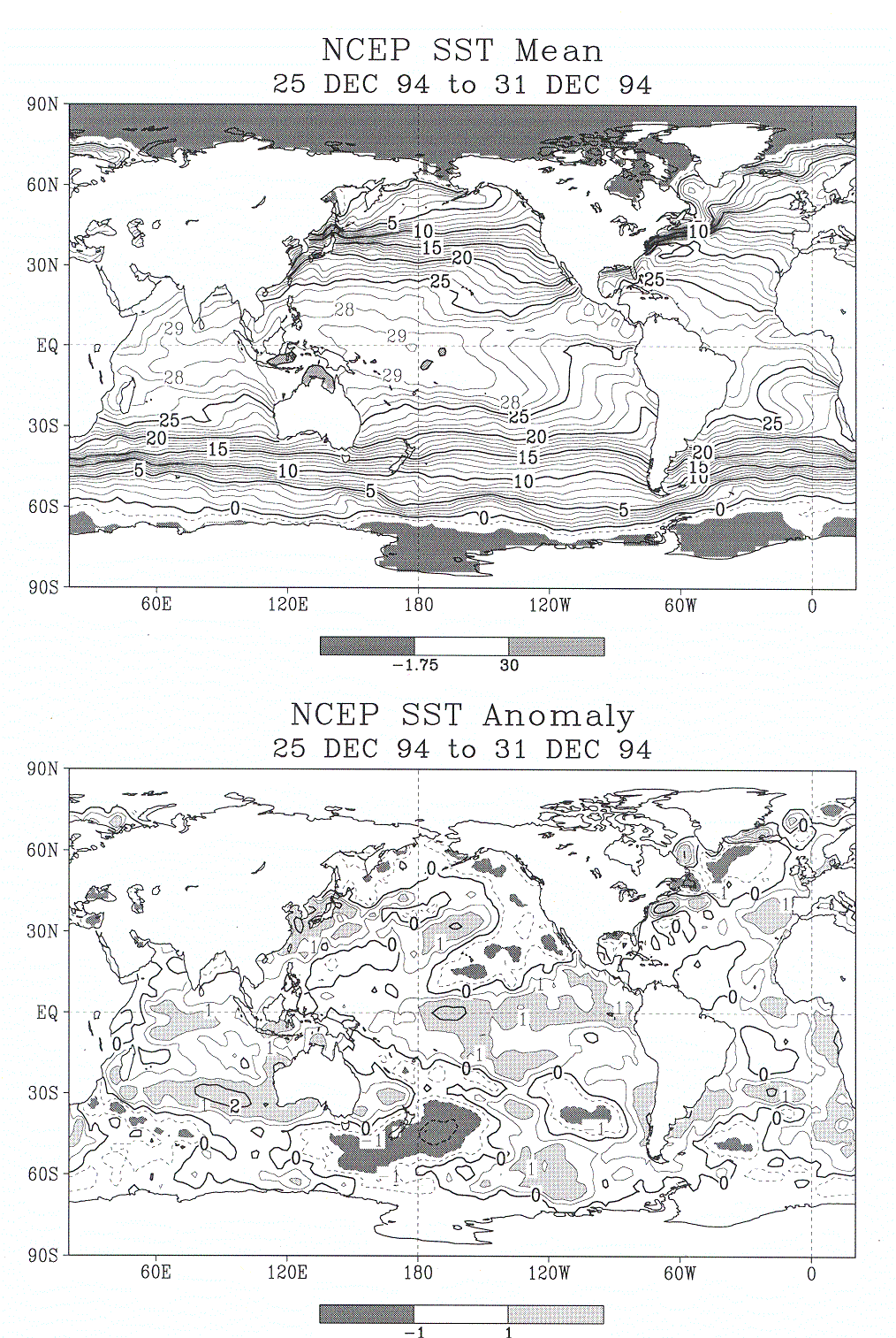
Figure 4: (top) SST weekly mean and (bottom) anomaly for December 25–31, 1994. The contour interval is 1°C, except there are two extra contours at ±0.5°C in Figure 4 (bottom). Negative contours are dashed. Heavy contour lines are used every 5°C in Figure 4 (top) and every 2°C in Figure 4 (bottom). In Figure 4 (top) the heavy shading at values < –1.75°C approximates the sea ice coverage. The anomalies are computed as departures from the monthly climatology of Reynolds and Smith [1995], which was interpolated to the weekly time period.
Most long atmospheric time series available for climate research derive from the operational activities of the WWW. At the start of TOGA, there were about 400 upper air reporting stations between 30°N and 30°S as part of the WWW, of which TOGA identified 150 as a minimal network for documenting planetary-scale variations in atmospheric circulation. Thus the basic elements of an upper air observing system existed at the outset of TOGA. Even so, this WWW network of stations was not adequate for TOGA purposes. As a consequence, initial planning for TOGA by the various scientific bodies noted the strong desirability of expanding the network of WWW rawinsonde sites in the tropics, especially in the Pacific and Indian Ocean sectors. Sites eventually instrumented under TOGA auspices included Tarawa, Kanton, Penrhyn, and San Cristóbal (in the Galápagos Islands) in the Pacific (Figure 5) and the island of Gan in the Indian Ocean. Unfortunately, the WWW network in the tropics in general underwent significant declines in data collection and exchange through the GTS during the TOGA decade for a variety of technological, political, and economic reasons [National Research Council, 1994a].
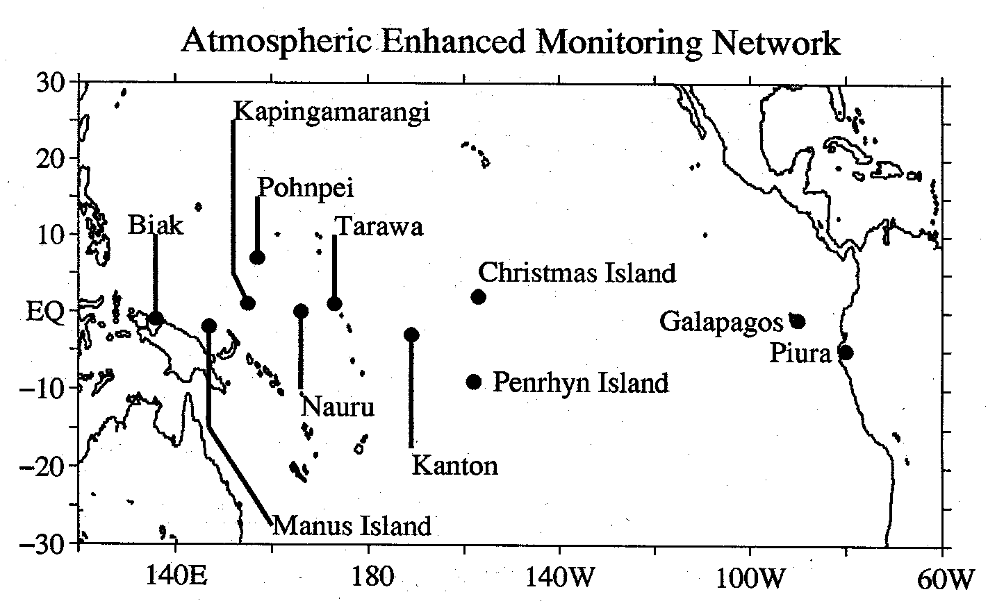
Figure 5: Map of the tropical Pacific Ocean basin
showing the locations of wind profilers and conventional upper air sounding
systems used for enhanced atmospheric observations during TOGA. Shown are VHF
and UHF profiler sites at Biak (Indonesia) and Christmas Island (Kiribati);
stand-alone VHF sites at Pohnpei (Federated States of Micronesia) and Piura
(Peru); stand-alone UHF profiler sites at Tarawa (Kiribati) and San Cristobal
(Galapagos Islands); and integrated sounding systems (ISS) at Manus Island (Papua
New Guinea), Kapingamarangi (Kiribati), and the island Republic of Nauru. The
ISS system consists of a UHF profiler integrated with a balloon sounding system
and surface meteorological instruments; the ISS sites at Manus Island, Nauru,
and Kapingamarangi were established as part of TOGA COARE. World Weather Watch
sites using conventional sounding systems were maintained at Tarawa, Kanton
(Kiribati), San Cristobal, and Penrhyn. Not shown is the World Weather Watch
(WWW) upper air sounding station site established by TOGA at Gan (0.5°16.1 S,
73°16.1E) in the Maldive Islands.
S,
73°16.1E) in the Maldive Islands.
TOGA also supported the establishment of wind profilers at several sites throughout the Pacific Basin (Figure 5), beginning with the 50-MHz very high frequency (VHF) wind profiler that commenced operation at Christmas Island in April 1986 [Gage et al., 1990, 1991a]. This Transpacific Profiler Network provides measurements of tropospheric winds between altitudes of 1.8 and 18 km height. Four times per day, hourly averaged VHF profiler data are telemetered via geostationary satellite and incorporated into the GTS for worldwide distribution. In addition, 915-MHz ultrahigh frequency (UHF) wind profilers were installed at Biak, Indonesia; Tarawa, Kiribati; and San Cristóbal, in the Galápagos Islands of Ecuador to provide more information on boundary layer wind variability.
Return to previous section or go to next section