While considerable effort has been devoted to exploring for submarine hydrothermal activity along the global mid-ocean ridge (MOR) system where tectonic plates are diverging, very little is known about the distribution and intensity of similar submarine activity on volcanic arcs where plates converge. de Ronde et al. [2001] made the first systematic study of hydrothermal activity in this tectonic setting along the southern Kermadec Arc. Their water column plume surveys showed that a substantial portion of the submarine volcanoes there are hydrothermally active [de Ronde et al., 2001]. Furthermore, in contrast to MOR activity that is mainly confined to the depth range of 2000-2500 m, the Kermadec Arc volcanoes were found to be introducing hydrothermal effluent at a wide variety of ocean depths, ranging from 100 to 1800 m.
During February-March 2003, as part of the Submarine Ring of Fire (SROF) project funded by NOAA's Ocean Exploration Program, the R/V Thomas G. Thompson conducted a comprehensive survey of submarine hydrothermal activity along a second volcanic arc, the Mariana Arc from 13.5°N to 22.5°N [Embley et al., 2004]. Plume surveys were conducted in the water column above ~50 Mariana Arc submarine volcanoes using a CTD/rosette system that included an Eh sensor for measuring in-situ oxidation-reduction potential. A total of 70 CTD casts were completed, and discrete water samples were collected for analysis of a variety of hydrothermal tracers, including ![]() He, CH
He, CH![]() , CO
, CO![]() , H
, H![]() S, Fe, Mn, pH, and suspended particles. The analysis of these samples showed that 12 of the Mariana Arc submarine volcanoes surveyed had active hydrothermal discharge. Of these, 8 were new sites and 4 were volcanoes previously known to be hydrothermally active [see Embley et al., 2004]. The newly discovered activity included that on NW Eifuku, a small volcanic cone located at 21.49°N, 144.04°E that rises to a depth of ~1535 m below sea level (Figures 1 and 2). NW Eifuku is the deepest in a cluster of 3 volcanoes that includes the larger neighboring volcanoes Daikoku and Eifuku. The water column samples collected over NW Eifuku in 2003 had excess concentrations of
S, Fe, Mn, pH, and suspended particles. The analysis of these samples showed that 12 of the Mariana Arc submarine volcanoes surveyed had active hydrothermal discharge. Of these, 8 were new sites and 4 were volcanoes previously known to be hydrothermally active [see Embley et al., 2004]. The newly discovered activity included that on NW Eifuku, a small volcanic cone located at 21.49°N, 144.04°E that rises to a depth of ~1535 m below sea level (Figures 1 and 2). NW Eifuku is the deepest in a cluster of 3 volcanoes that includes the larger neighboring volcanoes Daikoku and Eifuku. The water column samples collected over NW Eifuku in 2003 had excess concentrations of ![]() He, CO
He, CO![]() , CH
, CH![]() , Fe, and Mn, as well as pH, light backscattering (suspended particle), and Eh anomalies, all confined to the depth range of 1490 to 1620 m [Lupton et al., 2003; Resing et al., 2003].
, Fe, and Mn, as well as pH, light backscattering (suspended particle), and Eh anomalies, all confined to the depth range of 1490 to 1620 m [Lupton et al., 2003; Resing et al., 2003].
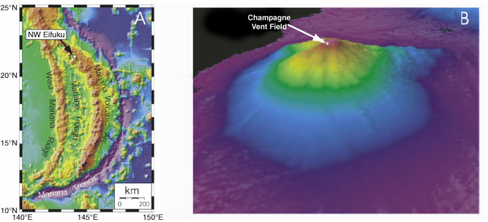
Figure 1. (a) Location map for NW Eifuku in the Mariana Arc. (b) Oblique 3-D representation of NW Eifuku viewed from the southwest, generated from EM300 bathymetry. No vertical exaggeration. Depths range from 1550 to 3000 m.

Figure 2. (a) Bathymetric map showing locations of Daikoku, Eifuku, and NW Eifuku submarine volcanoes. Box shows location of Figure 2b. (b) Detailed bathymetric map of NW Eifuku. Box shows location of Figure 2c. (c) High-resolution bathymetry of the summit of NW Eifuku, showing location of the Champagne site and Sulfur Dendrite (SD) and Cliff House (CH) vent sites. This high-resolution bathymetry was collected using the Imagenex sonar system mounted on the ROPOS ROV [Chadwick et al., 2001, 2004].
Return to Abstract or go to the next section