4.1.2. The eastern tropical Pacific
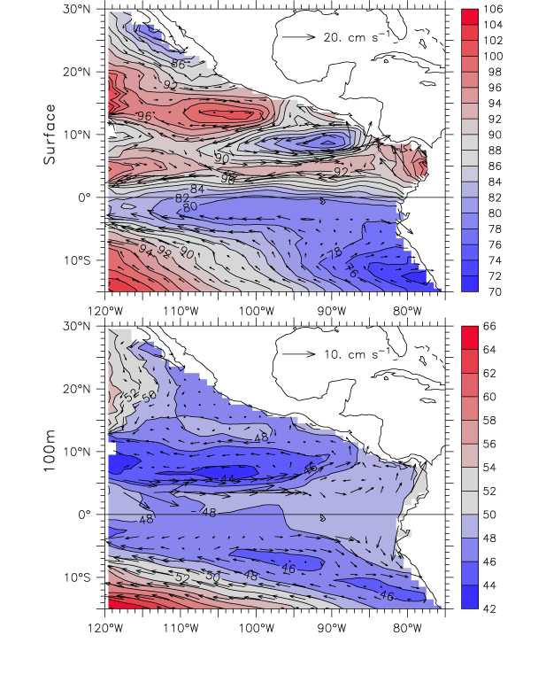
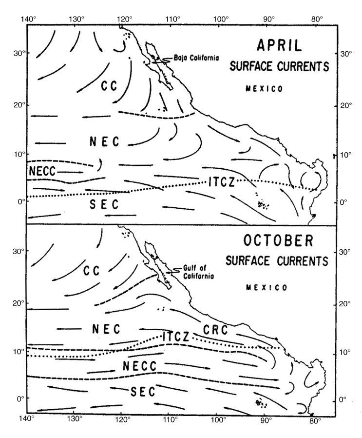
East of 120°W the picture is much more complicated and includes substantial meridional flow that feeds and drains the outgoing and incoming zonal currents. The southeastern corner of the North Pacific subtropical gyre occurs where the California Current flows south along the coast of Baja California and gradually turns west to feed the NEC, though its path is partly indirect, depth-dependent, and seasonally varying. Below the thermocline (Fig. 2, bottom) the turn to the west is clear, but at the surface (top panel), geostrophic currents continue southeastward along the coast of Mexico. However, the Ekman transport in this region is westward (i.e., to the right of the wind vectors in Fig. 1) so the very-near-surface flow is southsouthwest (Fig. 4), approximately parallel to the deeper geostrophic contours (Fig. 2). Part of the shallow geostrophic California Current probably continues southeast around the thermocline bowl centered at 13°N, 105°W (discussed below), to feed the NEC by a second pathway at about 13°N (Fig. 2, top), predominantly in boreal spring (Fig. 7). The NEC is also fed by water that has flowed east in the NECC, which extends all the way to the coast in boreal fall, but greatly weakens near 110°W in spring (Fig. 7), as discussed further below. These seasonal changes were already recognized by Wyrtki in 1965 (Fig. 3), but Figs. 2 and 5b show that the source region of the NEC comprises a complex mingling of currents that have not yet been fully deciphered.
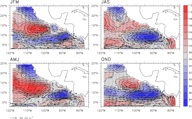
Fig. 7. Annual cycle of surface dynamic height and geostrophic current (relative to 450 m), shown as four average seasons. Red colors indicate high dynamic heights, blue low. The contour interval is 2 dyn cm. The scale vector for geostrophic currents is at lower left. The dynamic height contours shown here have very nearly the same patterns as contours of 20 °C depth for the corresponding season.
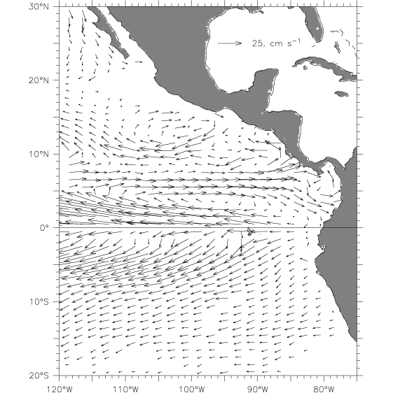
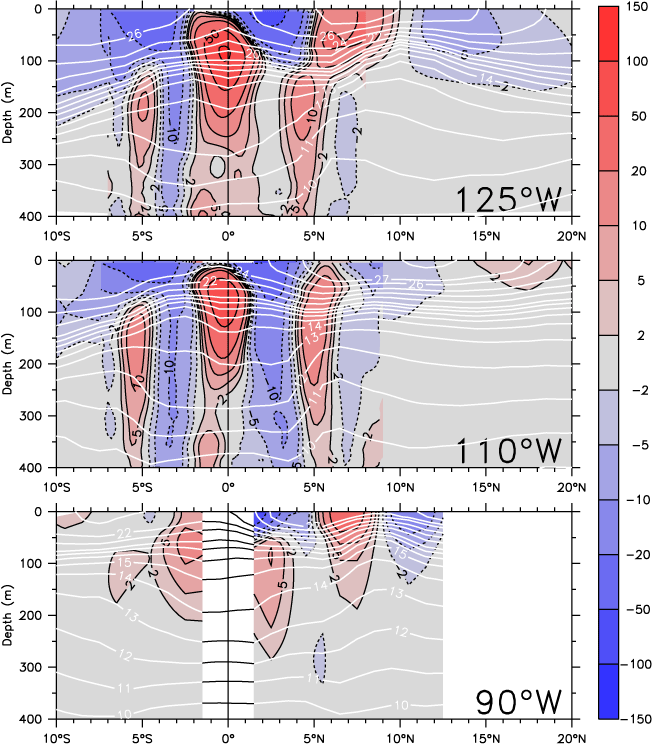
At 110°W, the structure of the EUC and SEC is similar to that at 125°W, though perhaps 20 m shallower, but the mean geostrophic NECC is nearly absent (Fig. 2, top and Fig. 6, middle). The ridge near 9–10°N that supports the NECC has almost completely flattened out (compare the isotherms in Fig. 6, middle vs. top). The weak eastward geostrophic flow found at 5–6°N is due to isotherm slopes below 13 °C; that is, associated with the Tsuchiya Jet and not the thermocline. Surface dynamic height has only a very small meridional pressure gradient between 5°N and 9°N at 110°W (about 2 dyn cm at 110 °W compared to about 14 dyn cm at 120°W; Fig. 2, top), as both the 10° ridge and 5°N trough nearly disappear. Much of the NECC splits, to turn south into the SEC and north into the NEC (note the dynamic height contours from 86 to 90 dyn cm turning north, and those from 94 to 98 dyn cm turning south between 120°W and 110°W, with only a small fraction of the geostrophic NECC continuing to the east). Similar patterns are shown in other climatologies (Strub and James, 2002b). This is a remarkable termination for a current well out in the interior basin. The mean drifter velocities, by contrast, show an apparently continuous NECC all the way from 120°W to the Costa Rica Dome (Fig. 4). The discrepancy is not due to sampling or other problems with the XBT data, as the directly measured currents show, if anything, a weaker mean surface NECC at 110°W (compare Fig. 6, middle, which uses directly measured currents south of 9°N, with Fig. 2, which is entirely geostrophic). Kessler (2002) noted that the Ekman flow under the region's southerly winds (Fig. 1) is strongly eastward, in part due to the small value of the Coriolis parameter this close to the equator. With reasonable assumptions about the Ekman depth (Ralph and Niiler, 1999), the Ekman currents account for nearly all the difference between the geostrophic (Fig. 2) and drifter (Fig. 4) depictions of the NECC at 110°W (see section 4b of Kessler, 2002). Thus the apparently continuous NECC seen by the drifters across 110°W is a near-surface Ekman feature that does not represent the geostrophic NECC that can be followed across the entire basin, and the NECC is therefore shown in Fig. 5b only as a near-surface current at 110°W. Since the Ekman flow is quite shallow the transport of the eastward jet in Fig. 4 is small, about 1 Sv over the width of the eastward current, compared to about 9 Sv for the geostrophic NECC at 125°W in Fig. 6. This mid-basin termination of the NECC is strongly seasonally modulated. In boreal spring, there is no eastward flow at all along 110°W anywhere south of the California Current (Fig. 7, lower left), whereas in boreal autumn and winter the NECC appears to flow all the way to the coast (right panels). The drifter seasonal cycle at 110°W shows the same pattern of variability, as do currents inferred from satellite altimetry (Strub and James, 2002b).
A striking bowl and dome are found in the mean dynamic height, centered at 13°N, 105°W and 9°N, 90°W, respectively (Fig. 2, top). (In the following, we will refer to these features as they appear in thermocline topography, not dynamic height; that is, the Costa Rica Dome at 9°N where the 20 °C isotherm rises to about 25 m, and the "Tehuantepec Bowl" at 14°N where 20 °C is at about 90 m. Note that the top panel of Fig. 2 is nearly equivalent to a map of the depth of the 20 °C isotherm which marks the thermocline, taking high dynamic height as corresponding to deeper isotherm depths.) Since the upwelling associated with the Costa Rica Dome produces a nutrient-rich environment that might support tuna and other fisheries, such as jumbo squid (Ichii et al., 2002), it has been studied much more intensely than the Tehuantepec Bowl, which does not even have a recognized name. These features appear to be the eastern ends of the thermocline trough and ridge that define the limits of the NEC across the basin, with the trough connecting to the center of the subtropical gyre and the ridge running along 9–10°N between the NEC and NECC all the way to the Philippines (Wyrtki, 1975b; Kessler, 1990). Notably, however, both the trough and ridge flatten near 110°W (as has been commented on above with respect to the NECC) before restrengthening near the coast and terminating in the nearly detached bowl and dome. They are clearly seen as counter-rotating eddies in the drifter (Fig. 4) and geostrophic (Fig. 2, top) velocity vectors. Although the Costa Rica Dome has a clear subsurface expression, extending much further to the west below the thermocline, the Tehuantepec Bowl is a shallow feature that is barely visible in the 100 m dynamic height (Fig. 2, bottom, and note that the 100 m dynamic height contours have a very similar pattern as the topography of the 12 °C isotherm).
Wyrtki (1964) noted the cool SST, low oxygen and high salinity and phosphate values in the center of the Costa Rica Dome as an indication of the upwelling of subthermocline water. Based on sections from several cruises, he estimated the current speed around the dome at about 20–50 cm s![]() , which is comparable to modern estimates (e.g., Fig. 4). Wyrtki hypothesized that the centrifugal acceleration around the Costa Rica Dome would contribute an outward divergence and consequent upwelling. The upwelling estimated this way was quite small, less than 0.1 Sv, about 1/30th the modern value, although the values of all the terms Wyrtki used were similar to those that would be used today. Wyrtki's assumption that the reason for the upwelling was rapid rotation around the eddy as the NECC turned at the coast, was the source of the error. If he had scaled the terms he would have found that the centrifugal term is at least 10 times smaller than the geostrophic term. In fact, Costa Rica Dome upwelling is driven by the wind, as discussed in Section 4.1.3 below, which Wyrtki (1964) dismissed as weak and variable in the absence of sufficient observations, and he omitted wind forcing from his balance.
, which is comparable to modern estimates (e.g., Fig. 4). Wyrtki hypothesized that the centrifugal acceleration around the Costa Rica Dome would contribute an outward divergence and consequent upwelling. The upwelling estimated this way was quite small, less than 0.1 Sv, about 1/30th the modern value, although the values of all the terms Wyrtki used were similar to those that would be used today. Wyrtki's assumption that the reason for the upwelling was rapid rotation around the eddy as the NECC turned at the coast, was the source of the error. If he had scaled the terms he would have found that the centrifugal term is at least 10 times smaller than the geostrophic term. In fact, Costa Rica Dome upwelling is driven by the wind, as discussed in Section 4.1.3 below, which Wyrtki (1964) dismissed as weak and variable in the absence of sufficient observations, and he omitted wind forcing from his balance.
Northwestward flow on the east side of the Costa Rica Dome is known as the Costa Rica Coastal Current, with a mean speed of about 20 cm s![]() , and a transport of more than 5 Sv (Fig. 2). In the mean, the CRCC continues along the coast into the Gulf of Tehuantepec, where its surface expression turns south to flow around the south side of the Tehuantepec Bowl. This northward extension is seasonally modulated as the Costa Rica Dome expands and contracts (Fig. 7). The CRCC extends quite deeply into the water column, with an appreciable flow below the thermocline (Fig. 2, bottom; and see also Fig. 8, bottom).
, and a transport of more than 5 Sv (Fig. 2). In the mean, the CRCC continues along the coast into the Gulf of Tehuantepec, where its surface expression turns south to flow around the south side of the Tehuantepec Bowl. This northward extension is seasonally modulated as the Costa Rica Dome expands and contracts (Fig. 7). The CRCC extends quite deeply into the water column, with an appreciable flow below the thermocline (Fig. 2, bottom; and see also Fig. 8, bottom).

Fig. 8. Zonal sections of temperature (top) and meridional geostrophic current (bottom) along 8.5°N, from the coast (right edge) to 110°W. The contour interval for temperature is 1 °C from 8 to 14 °C, then 2 °C from 16 to 26 °C, then 1 °C from 27 to 29 °C; the 20 °C contour is darkened. In the bottom panel, northward current is indicated by solid contours, southward by dashed contours; the contour interval is every 5 cm within ±15 cm s![]() , with additional contours at ±1 and 2, ±0.5 and ±0.2 cm s
, with additional contours at ±1 and 2, ±0.5 and ±0.2 cm s![]() .
.
The paucity of ocean data along the southwest coast of Mexico has led to considerable confusion about the possible extension of the CRCC to the north. Wyrtki (1965) showed it continuing all the way up past the tip of Baja California in October (Fig. 3, bottom), and this interpretation has continued to be cited (Baumgartner and Christensen, 1985; Badan-Dangon, 1998). In the absence of velocity data, the fact that Gulf of California surface and subsurface water properties apparently originated in the central Pacific argued for the CRCC as the likely pathway (Badan-Dangon, 1998; Lavín et al., 2003). Nevertheless, neither the drifter (Fig. 4) nor geostrophic (Fig. 2) velocities indicate the mean surface CRCC continuing north past the Gulf of Tehuantepec. Instead, anticyclonic flow around the Tehuantepec Bowl produces a strongly southeastward current along the coast of Oaxaca into the Gulf of Tehuantepec that cuts off the CRCC and forces it to turn offshore (most of which eventually feeds the NEC). However, as noted above, the Tehuantepec Bowl is a shallow feature that occurs almost entirely above the 12 °C isotherm (near 200 m depth), and a thin finger of subthermocline poleward flow continues along the coast past the Gulf of Tehuantepec, as suggested by the 48 dyn cm contour extending along the coast as far as 100 °W (Fig. 2, bottom). Northwest of the Tehuantepec Bowl, a weak subthermocline dome and cyclonic circulation centered at 19°N, 109°W (Fig. 2, bottom) feeds California Current water to the coastal current. North of 17°N, the poleward coastal flow strengthens and extends to the surface to flow past Cabo Corrientes at 20°N with a mean speed of about 3 cm s![]() and transport of 1–2 Sv. Numerical models indicate a similar pattern, but with larger current speeds (E. Beier, personal communication, 2004). Since this coastal current appears not to be simply a continuation of the CRCC, either in its velocity structure or in the water masses that it carries, we propose that it be called the "West Mexican Current" (WMC), which is shown schematically in Fig. 5b as an initially subsurface, then surface flow. With the sparse sampling in the region, the interconnections among the WMC, Tehuantepec Bowl and California Current remain poorly known, and we have indicated this uncertainty with a question mark in Fig. 5b.
and transport of 1–2 Sv. Numerical models indicate a similar pattern, but with larger current speeds (E. Beier, personal communication, 2004). Since this coastal current appears not to be simply a continuation of the CRCC, either in its velocity structure or in the water masses that it carries, we propose that it be called the "West Mexican Current" (WMC), which is shown schematically in Fig. 5b as an initially subsurface, then surface flow. With the sparse sampling in the region, the interconnections among the WMC, Tehuantepec Bowl and California Current remain poorly known, and we have indicated this uncertainty with a question mark in Fig. 5b.
The Tehuantepec Bowl weakens and retreats offshore during boreal summer (Fig. 7) (the dynamics that control this evolution are discussed below in Section 4.2.1). This weakens the coastal currents that block the surface CRCC, allowing additional leakage to the north around a weak feature along the Oaxaca coast in summer (Fig. 7). The 19°N, 109°W dome also becomes more evident at this time. During June–October, WMC speeds increase to more than 5 cm s![]() , and it presumably transports more tropical water to the Gulf of California at that time (similar boreal summer poleward anomalies are also seen in currents diagnosed from satellite altimetric sea level (Strub and James, 2002b)). In Section 4.4 below, increased poleward transport to the Gulf of California during El Niño events is inferred; it is possible that these episodic surges could, over time, deliver a significant contribution to the water of tropical origin observed in the Gulf (Baumgartner and Christensen, 1985; Lavín et al., 2003). The single existing (published) hydrographic section across the WMC was made in December 1969, a few months after its usual seasonal maximum but at the height of an El Niño event (Roden, 1972). This showed a strong (46 cm s
, and it presumably transports more tropical water to the Gulf of California at that time (similar boreal summer poleward anomalies are also seen in currents diagnosed from satellite altimetric sea level (Strub and James, 2002b)). In Section 4.4 below, increased poleward transport to the Gulf of California during El Niño events is inferred; it is possible that these episodic surges could, over time, deliver a significant contribution to the water of tropical origin observed in the Gulf (Baumgartner and Christensen, 1985; Lavín et al., 2003). The single existing (published) hydrographic section across the WMC was made in December 1969, a few months after its usual seasonal maximum but at the height of an El Niño event (Roden, 1972). This showed a strong (46 cm s![]() maximum), narrow (less than 100 km wide) surface-intensified current immediately against the coast at Cabo Corrientes, with northward flow to 700 m depth. Such a spatial pattern is consistent with the transient passage of an El Niño-generated coastal wave, though it is impossible to verify this
maximum), narrow (less than 100 km wide) surface-intensified current immediately against the coast at Cabo Corrientes, with northward flow to 700 m depth. Such a spatial pattern is consistent with the transient passage of an El Niño-generated coastal wave, though it is impossible to verify this
Return to previous section or go to next section