U.S. Dept. of Commerce / NOAA / OAR / PMEL
/ Publications
Direct measurements of upper ocean currents and water properties
across the tropical Pacific during the 1990's
Gregory C. Johnson, Bernadette M. Sloyan1, William
S. Kessler, Kristene E. McTaggart
NOAA/Pacific Marine Environmental Laboratory, Seattle, WA 98115-6349,
USA
1Present address: Woods Hole Oceanographic Institution, Woods
Hole, MA 02543-1050, USA
Prog. Oceanogr. , 52 (1), 31-36,
2002.
Copyright 2002 Elsevier Science Ltd. Further
electronic
distribution is not allowed.
4. Zonal current properties and their variation
The EUC, NECC, and both branches of the SEC are analyzed for each synoptic
section. Quantities evaluated include zonal volume transport as well as velocity-weighted
latitude, depth, potential temperature, and salinity for each current at each
longitude. These quantities are estimated only where the sections have sufficient
meridional and vertical coverage in currents and water properties to sample
fully the current. The NECC was the least frequently sampled current by the
synoptic sections, followed by the SEC(S). These quantities are then fitted
in the same manner as the section data discussed above.
In this analysis, the EUC is defined as all eastward flow between 2°N
and 2°S (Gouriou & Toole, 1993) for potential densities of 23 <  < 26.5
kg m3. In the west, the latitudinal limits
help separate the EUC from the NSCC and the SSCC at depth, as well as from
the surface NECC. The lighter limit helps to distinguish the EUC from transient
eastward-flowing surface jets driven by local westerly wind events (Cronin
et al., 2000), especially in the west. The denser limit attempts to distinguish
the EUC from deeper eastward flows that are sometimes present below the EUC,
usually separated by a velocity reversal (the EIC) or a minimum in eastward
velocity.
< 26.5
kg m3. In the west, the latitudinal limits
help separate the EUC from the NSCC and the SSCC at depth, as well as from
the surface NECC. The lighter limit helps to distinguish the EUC from transient
eastward-flowing surface jets driven by local westerly wind events (Cronin
et al., 2000), especially in the west. The denser limit attempts to distinguish
the EUC from deeper eastward flows that are sometimes present below the EUC,
usually separated by a velocity reversal (the EIC) or a minimum in eastward
velocity.
The NECC is here defined as all eastward flow north of 2°N for < 26.0
kg m3. To be used for NECC estimates, the
velocity and density fields had to suggest that the northern edge of the NECC
was sampled. This restriction meant that the sections usually had to reach
to 8°N or beyond, which unfortunately, but unavoidably, creates some
potential for a biased sample. The 26.0 kg m3 density
limit is near the base of the thermocline and helps to distinguish the NECC
from the NSCC. The current separation is on the whole a bit denser than previous
ones at 165°E based on the minimum in eastward velocity (Gouriou & Toole,
1993), and at 110°W based on 
 (Hayes,
Toole, & Mangum, 1983).
(Hayes,
Toole, & Mangum, 1983).
The SEC(N) is defined as all westward flow between the equator and the NECC,
and again for < 26.0
kg m3. The SEC(S) is defined as all westward flow between 8°S
(because most of the sections stop at that latitude) and the equator for < 26.0
kg m3. In the far west, around 143°E, New Guinea is substituted
for 8°S as the southern limit of the SEC(S). In this region, upper portions
of the NGCUC are counted as part of the SEC(S). The density limit for both
branches of the SEC is consistent with that for the NECC.
The synoptic analysis presents a picture different from that of the mean section
analysis in at least three ways. First, in the synoptic analysis each section
is reduced to a set of single parameters before fitting. Thus the fits have
less structure than the mean analysis, since the mean analysis allows independent
variations in the properties on isopycnals and the depth of those isopycnals.
Deviations of current properties with respect to the ENSO cycle in the synoptic
analysis are just linear perturbations of the mean properties regressed against
the SOI and the seasonal cycle is a pure annual harmonic. Thus, only El Niño
fits are shown, since La Niña fits contain no additional information. For each
current and quantity the means and the variations with the ENSO cycle (shown
as a strong El Niño by evaluating the fits at SOI = 1.5) are presented as
functions of longitude. The seasonal cycle is shown separately.
The second difference is that the synoptic section analysis exactly follows
the currents as they move horizontally and vertically, within the density and
latitude limits noted above: a Lagrangian approach. However, while the mean
section analysis is quasi-Lagrangian in the vertical, since it is done on isopycnals,
it is closer to Eulerian in the meridional. The annual harmonics and regression
against the SOI in the mean section analysis accounts for some of the currents meridional
migrations, but not all of them. That is to say, currents are not completely
followed as they move north or south with various higher frequency motions
such as TIWs and other disturbances.
The third difference is that the synoptic section analysis defines currents
as all flow in a given direction and region as noted above. With this definition,
there are never any current reversals portrayed in individual sections, just
absences of currents, which are fitted as zero transport and omitted from the
other property fits. This situation contrasts with the mean section analysis,
which includes velocity reversals at any given latitude and isopycnal. These
last two differences combine for stronger current transports in the fits of
the synoptic section analysis than in the mean section analysis.
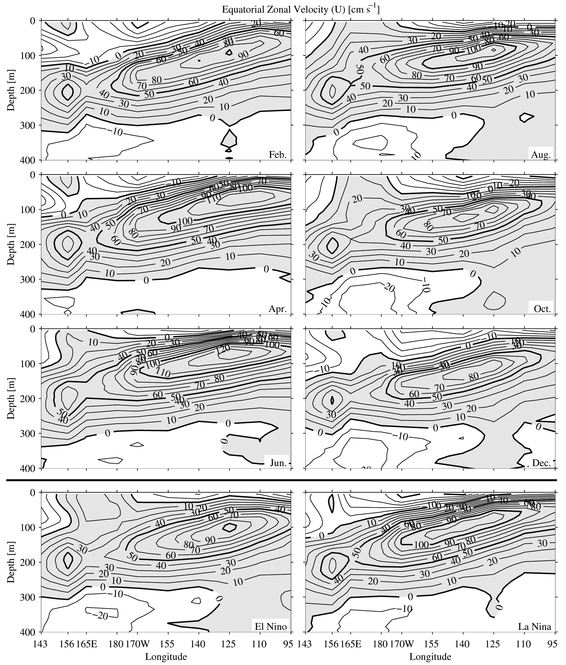
4.1. Zonal current volume transports
Variations of the equatorial zonal currents are closely connected to seasonal
and ENSO cycle changes in the equatorial easterlies. Equatorial zonal winds
affect the surface currents primarily through downwind frictional forcing and
setup of a zonal pressure gradient, which exerts an upwind forcing below the
frictional layer. Thus, when the easterly trade winds are strong, they tend
to spin up both the westward SEC at the surface and, after time, the eastward
EUC beneath. By elevating the equatorial thermocline (through upwelling caused
by local Ekman divergence and non-local wave adjustments), strong trades also
tend to produce meridional pressure gradients that foster westward off-equatorial
currents. During El Niño, or during the phase of the annual cycle with westerly
anomalies, the opposite changes occur.
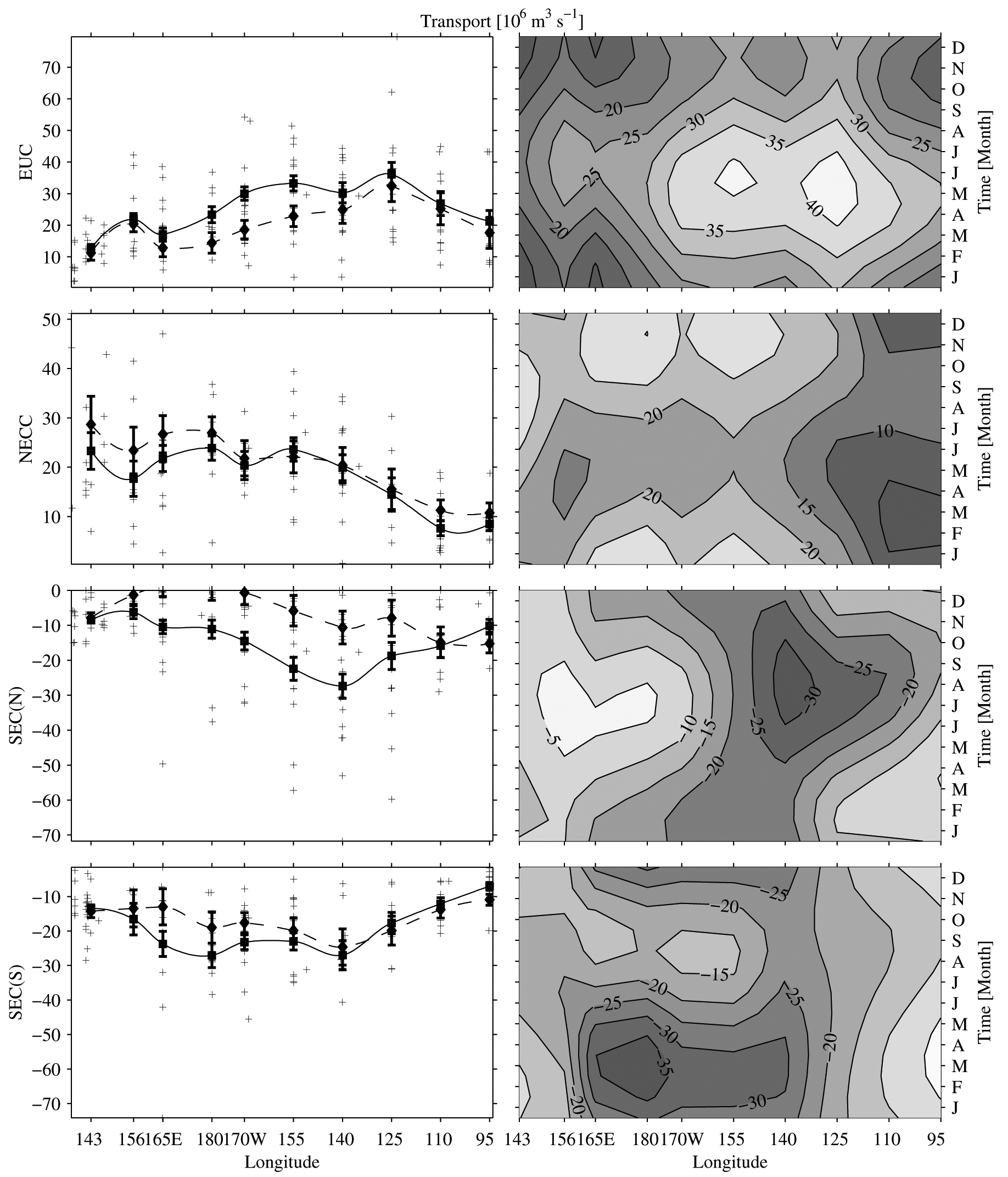
The mean volume transport of the EUC (Figs. 17 and 5) is larger in the central
Pacific than in the west or the east. In the central Pacific the trade winds
are strongest, the zonal thermocline slope and thus the zonal pressure gradient
is the biggest, and so the EUC is the largest. The seasonal cycle in EUC transport
is substantial at all longitudes. The phasing is such that EUC transport peaks
in mid-May in the east and late June in the west, as the relaxed trade winds
during this time allow increased eastward flow in the upper half of the EUC
(Philander, Hurlin, & Seigel, 1987). This westward phase propagation in
the EUC agrees with model results (Blanke & Raynaud, 1997) and empirical
analyses (Yu & McPhaden, 1999). The weakening or disappearance of the EUC
during the height of El Niño was observed during the events of 198283 (Firing,
Lukas, Sadler, & Wyrtki, 1983), 198687 (McPhaden, Hayes, Mangum, & Toole,
1990), 199192 (Kessler & McPhaden, 1995) and 199798 (Johnson et al.,
2000).
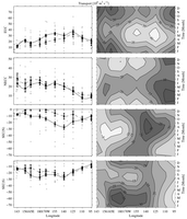
Fig. 17. Zonal current volume transport (106 m3 s–1)
for (from top to bottom) the EUC, NECC, SEC(N), and SEC(S). Left panels show
the quantity with error bars versus longitude for means (GRAPHIC_HERE joined
by solid lines), SOI = –1.5 strong El Niño (GRAPHIC_HERE joined
by dashed lines), and raw data (+). Right panels show contours of the seasonal
cycle versus longitude. Contour interval in the right panels is 5 × 10⁶ m3 s–1 and
the y-axis tick marks on the left panels are at twice that interval.
The mean transport of the NECC is fairly constant over the western and central
Pacific, but decreases in the east, becoming smallest around 110°W (Fig.
17). This minimum at 110°W is as expected from the Sverdrup relation
(Kessler, 2002). The sampling in the far west is sparse and the transport
uncertainties are correspondingly large. The seasonal cycle is a large fraction
of the mean transport of the NECC. The NECC has its largest transport in August
at 95°W, but at and west of 125°W the maximum in transport occurs
in OctoberDecember, except near 143°E, which probably sees the influence
of the western boundary. This shift with longitude is again a signature of
westward phase propagation. Around February the NECC is very weak east of 125°W.
During El Niño events, the NECC is important for export of water eastward from
the warm pool, and its transport increases by about 25% (Picaut, Ioualalen,
Menkes, Delcroix, & McPhaden, 1996). Central Pacific transport NECC variations
with the SOI are aliased by TIWs as discussed in Section 3.2.
Transport estimates for the westward-flowing SEC(N) are difficult and rarely
direct (Wyrtki, 1974a; Wyrtki & Kilonsky, 1984; Picaut & Tournier,
1991). The mean volume transport of this current peaks in amplitude in the
central Pacific (Fig. 17). Throughout the basin, but especially in the western
Pacific where the NECC is closest to the equator, the SEC(N) is sometimes absent.
The current transport estimated through the synoptic analysis in the west is
clearly large compared with the mean fields estimated on isopycnals (Fig.
8).
This example best highlights this difference between the synoptic current transport
analysis and the mean fit fields as discussed in Section 4.
Much like the NECC, the seasonal cycle of the SEC(N) volume transport is such
that the current is weakest in FebruaryMarch in the east, but this lull transitions
to around July in the west (Fig. 17; Wyrtki, 1974a). Depth fluctuations of
the thermocline trough near 4°N5°N affect both the SEC(N) to the south and the NECC to the north, by
simultaneously modulating the pressure gradients across the two currents. As
a result, their transport variations tend to be approximately in phase (Kessler & Taft,
1987). The local manifestation of an annual equatorial Rossby wave at 5°N
(Yu & McPhaden, 1999) accounts for most of the annual variability of the
depth of the trough (Kessler, 1990). This wave is forced by the wind stress
curl resulting from the annual northsouth migration of the ITCZ. The amplitude
of the seasonal cycle is large throughout the basin. Unfortunately, the SEC(N)
and NECC transport estimates around 140°W are aliased by energetic TIWs
sometimes present in the central Pacific as discussed in Section 3.2.2. The
TIW signal is reflected by the relatively wide distribution of transport estimates
for these currents in that region (Fig. 17).
West of 110°W, the SEC(N) is greatly reduced during El Niño, at least
partly because of the reduction in the trades. The deepening of the equatorial
thermocline reduces the meridional pressure gradient and results in anomalously
eastward surface geostrophic velocities during El Niño, with a reduced SEC
and an increased NECC. Momentum advection driven by cross-equatorial southerly
winds may also be important in the SEC(N) dynamics in the central to eastern
Pacific (Philander et al., 1987).
The SEC(S) mean volume transports (Fig. 17) build from fairly small values
at 95°W to nearly constant values west of 140°W, before diminishing
again west of 165°E. As mentioned before, at 143°E the upper part of the NGCUC is folded into these SEC(S) transport
estimates. The amplitude of the seasonal cycle is large only between 165°E
and 155°W, with the current being strongest in FebruaryMarch, roughly
in opposite phase with the SEC(N). The volume transport decreases significantly
only in the west during El Niño (except at 143°E where the NGCUC is strong
during that phase of ENSO). This change is a different, but much less dramatic,
response to the reduction in trade wind forcing than that seen in the SEC(N).
The zonal asymmetry may result from an enhancement of the South Pacific Convergence
Zone (SPCZ) during El Niño, which increases the SECC and reduces the SEC(S)
in the western Pacific (Kessler & Taft, 1987). It is important to remember
that there may be SEC(S) fluctuations beyond 8°S that are missed by this
data set.
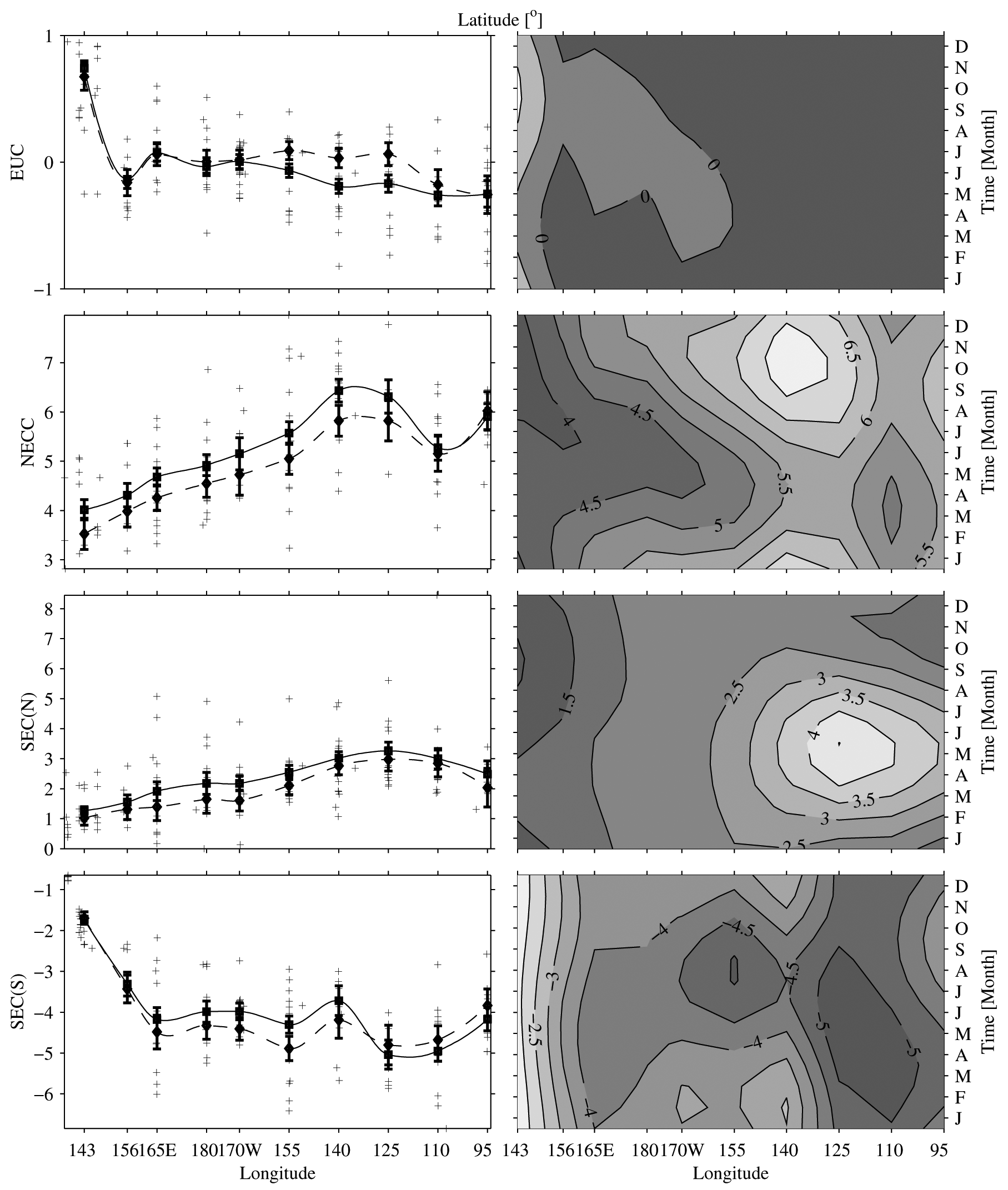
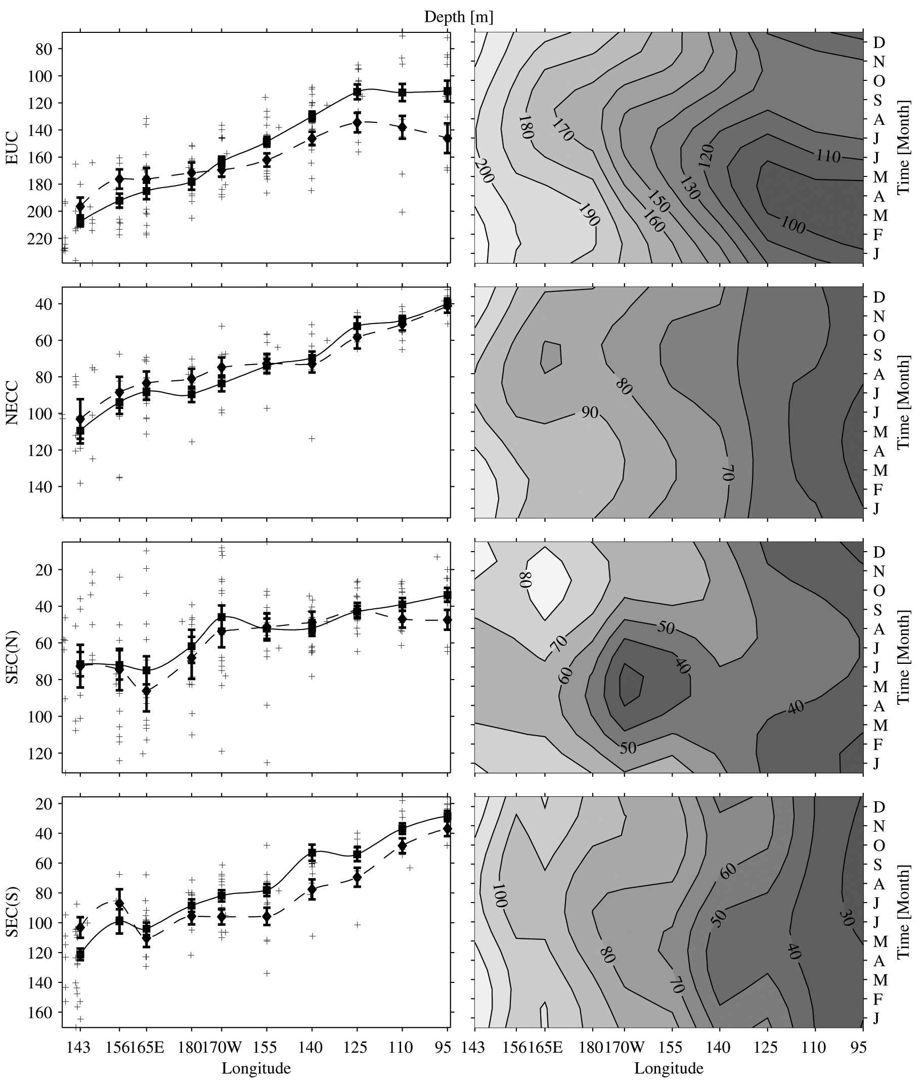
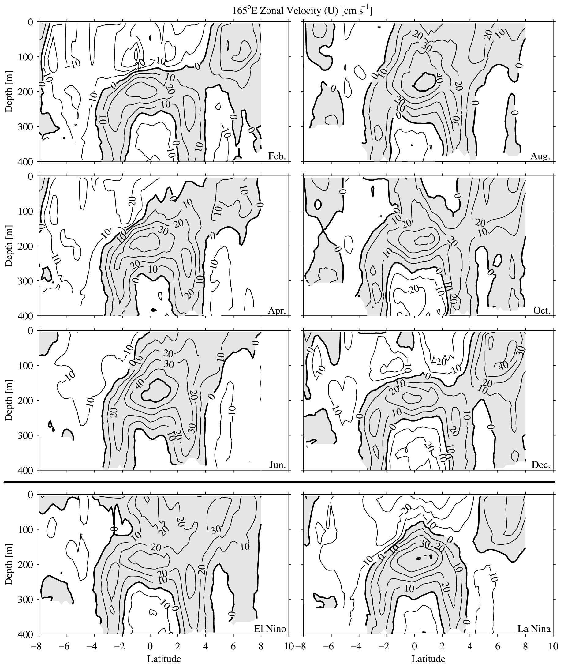
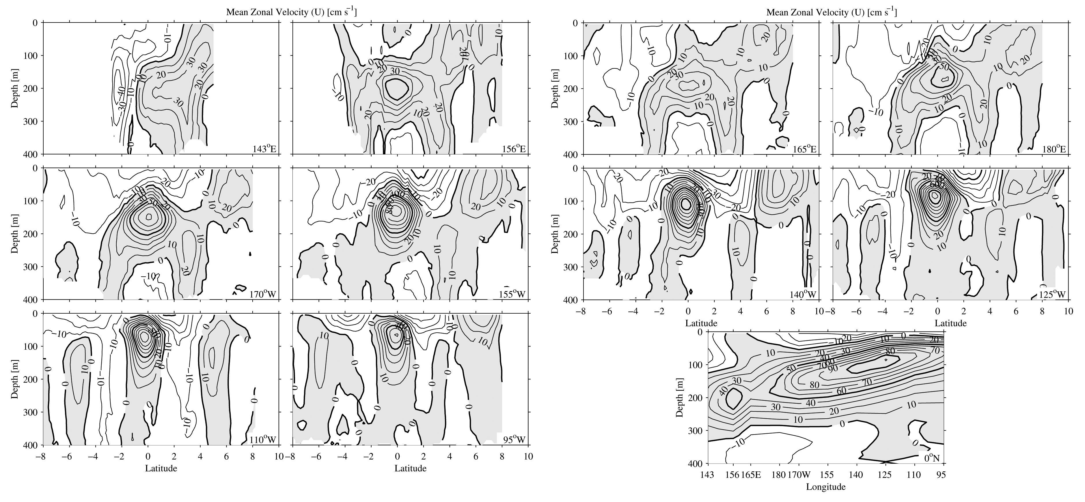
4.2. Zonal current latitudes and depths
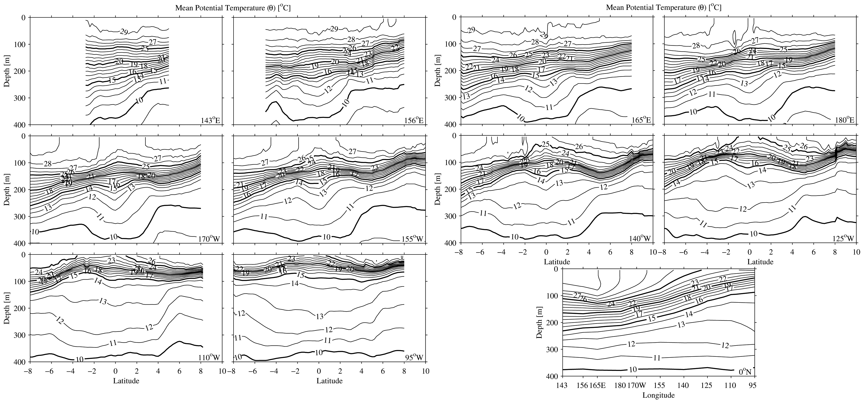
The mean latitude of the EUC (Figs. 18 and 2) is near the equator except at
143°E where the NGCUC is strong. The EUC core shifts slightly south of
the equator in the east, owing to the meridional circulation induced by predominantly
southerly winds in that region (Philander & Delecluse, 1983; Kessler, Rothstein, & Chen,
1998). Eastward shoaling of the EUC is apparent in the mean from 143°E
to 125°W, but the velocity-weighted EUC is relatively constant in depth
east of that longitude (Fig. 19) while the peak velocity continues to shoal
slightly (Fig. 3).
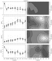
Fig. 18. Zonal velocity-weighted current latitude (°) for (from top
to bottom) the EUC, NECC, SEC(N), and SEC(S). Contour interval in the right
panels is 0.5° and the y-axis tick marks on the left panels are
at twice that interval. Details follow Fig. 17.
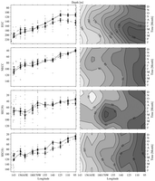
Fig. 19. Zonal velocity weighted current depth (m) for (from top to bottom)
the EUC, NECC, SEC(N), and SEC(S). Contour interval in the right panels is
10 m and the y-axis tick marks on the left panels are at twice that
interval. Details follow Fig. 17.
The seasonal cycle of EUC depth is very smooth and well defined. The current
shoals in March at 95°W, and this shoaling generally lags to the west
(except closest to the western boundary), with maximum shoaling in August by
165°E. This westward propagation is a signature of an annual Rossby wave
(Lukas & Firing, 1985; Kessler & McCreary, 1993). Shallower depths
are generally associated with large transports in the seasonal cycle, although
there are some phase differences between seasonal EUC transport and depth.
This correlation arises as the EUC picks up eastward transport in the shallower
layers with relaxed trade winds. The seasonal cycle of EUC latitude is very
small except in the far west. During El Niño the EUC shifts northward toward
the equator in the central Pacific. During this phase of ENSO the EUC deepens
considerably in the east, and shoals in the west, consistent with the reduced
zonal slope of the equatorial thermocline.
The mean latitude of the NECC moves gradually northward as the current progresses
from west to east, with an interruption of this tendency at 110°W (Figs.
18 and 2), where the mean transport is weakest (Fig.
17). At this longitude
the NECC and NSCC are difficult to distinguish because the NECC is very weak,
so there is little eastward velocity above the thermocline. The NECC also shoals
from west to east (Fig. 19) with the shoaling thermocline. The seasonal cycle
of latitude is such that the NECC is generally found furthest south when its
volume transport is at a minimum. The seasonal cycle of depth is notable only
west of 125°W, with the current being slightly deeper in FebruaryApril.
During El Niño the NECC is found south of its usual latitude in the western
and central Pacific, and it shoals in the western Pacific with a hint of deepening
in the east, as expected from the migration of the warm pool to the east during
this phase of ENSO.
The mean latitude of the SEC(N) starts near 2°N in the east, approaches
3°N in the central Pacific (Figs. 18 and 2), where the current is strongest,
and then tends southward to 1°N in the west where the current weakens. The SEC(N) also deepens to
the west (Fig. 19), again with the westward deepening of the thermocline until
it reaches the warm pool, where the depth remains constant. The seasonal cycle
of latitude is such that the SEC(N) is generally furthest north when its volume
transport is at a minimum, in contrast with the seasonal cycle of the NECC.
The current is shallowest in JanuaryFebruary in the east, with a westward
lag toward shallowest values in MayJune in the west. Deeper values are correlated
with larger transports. During El Niño the current moves southward as it weakens
in transport, again consistent with eastward migration of the warm pool. Interestingly,
during El Niño it also deepens in the west as its transport decreases, because
surface flow tends to be eastward during this time and the SEC(N) is sometimes
limited to a subsurface expression.
The SEC(S) is located from 4°S to 5°S in the mean (Fig.
18), except
near the western boundary where it is forced northward by New Guinea and joins
the NGCUC. Of course, this latitude is somewhat influenced by the southern
limit of 8°S in this analysis. Like the rest of the currents, the SEC(S)
deepens to the west (Fig. 19) with the thermocline. In the seasonal cycle,
the SEC(S) also generally shifts south when transports are weakest. The seasonal
cycle of the SEC(S) depth is such that it is shallowest in MayAugust, roughly
in phase with the SEC(N). The current shifts southward in the west and weakens
under El Niño conditions. During El Niño, like the SEC(N), the current deepens
(except in the far west where the NGCUC influences the analysis) for the same
reason: a tendency toward increased eastward surface flows.
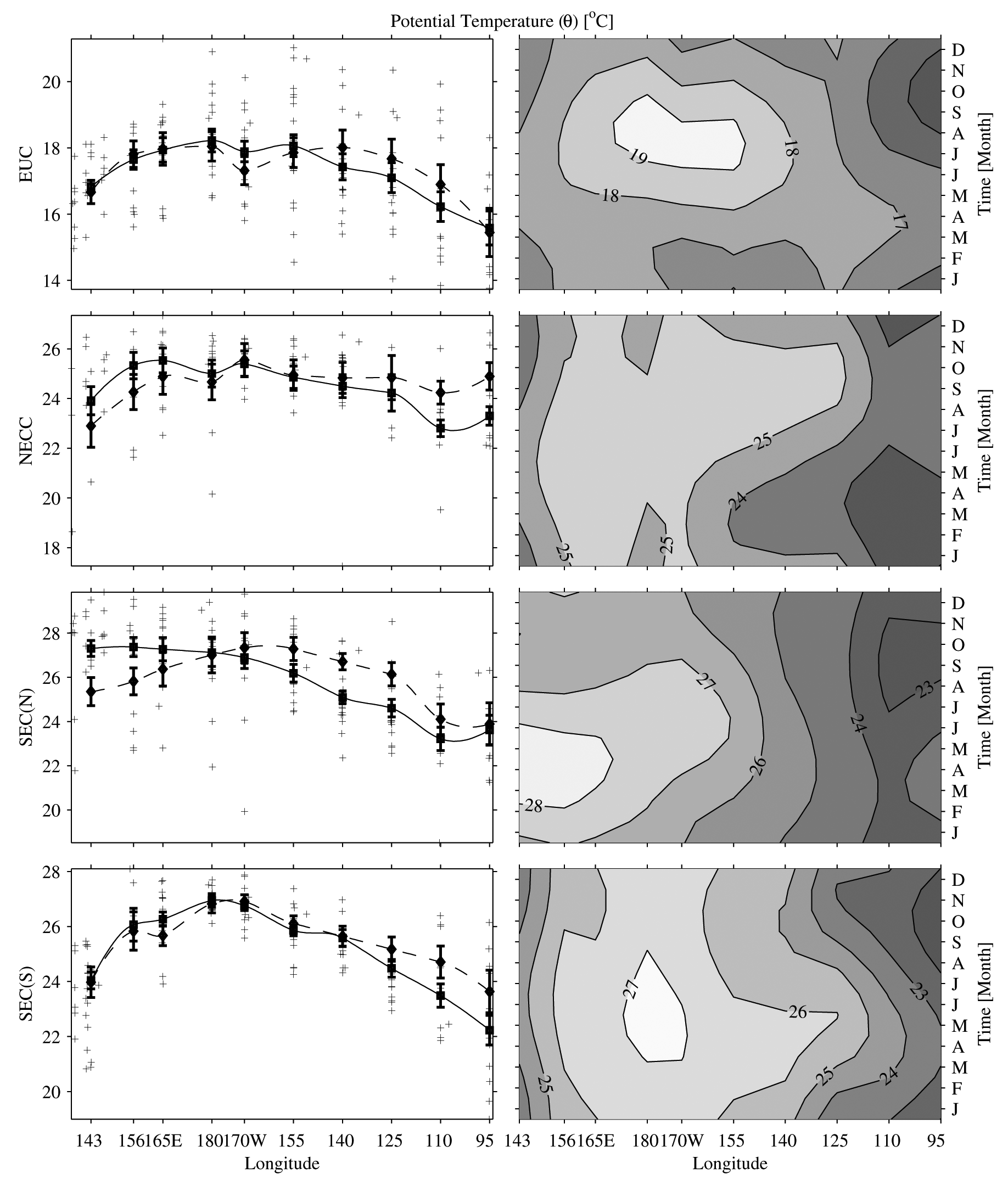
4.3 Zonal current temperatures and salinities
In the mean the EUC is warmest (Fig. 20) and saltiest (Fig.
21) near the dateline.
These changes occur because the current adds warm and salty water from the
southern hemisphere (Johnson & McPhaden, 1999) as it moves eastward, but
then as it surfaces in the east its warmer and saltier waters upwell into the
SEC. The seasonal cycle is such that the EUC is warmer and saltier when the
transport is largest, because the upper layers of the EUC, which are warmer
and saltier, make up most of the seasonal variability. During El Niño
there is some warming of the EUC in the eastern Pacific, owing to more near-surface
eastward flow under the relaxed trades. During El Niño there is also
some freshening of the EUC in the western Pacific, perhaps associated with
eastward migration of the fresh pool in the upper portions of the EUC.
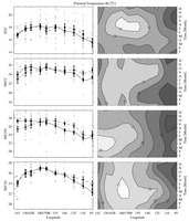
Fig. 20. Zonal velocity-weighted current temperature (°C) for (from
top to bottom) the EUC, NECC, SEC(N), and SEC(S). Contour interval in the right
panels is 1°C and the y-axis tick marks on the left panels are
at twice that interval. Details follow Fig. 17.
Fig. 21. Zonal velocity-weighted current salinity (PSS–78) for (from
top to bottom) the EUC, NECC, SEC(N), and SEC(S). Contour interval in the right
panels is 0.1 and the y-axis tick marks on the left panels are at twice
that interval. Details follow Fig. 17.
The NECC temperature is relatively warm (Fig. 20) and fresh (Fig.
21), but
it cools a little and freshens a lot in the mean as it flows eastward under
the high precipitation of the ITCZ. The seasonal cycle is such that the NECC
is warmest and freshest when the transports are largest, because near-surface
intensification accounts for much of the seasonal cycle. During El Niño
the NECC tends to be warmer in the east, and fresher in the central Pacific.
The latter change is probably a result of large-scale precipitation changes
and eastward advection of the fresh pool.
The SEC(N) is cool (Fig. 20) and fresh (Fig.
21) in the east where it flows
adjacent to the ITCZ and to the fresh coastal surface waters. It warms and
becomes increasingly salty to the west. The seasonal cycle of temperature is
such that larger transports are generally associated with cooler temperatures.
The seasonal cycle of salinity is really only large in the east, where the
current is freshest in January, a time when its transport is low and the ITCZ
has moved south over the current. As might be expected, the SEC(N) is slightly
warmer in the east during El Niño, when the cold equatorial upwelling
that feeds it is suppressed. The salinity shows no change with variations of
the ENSO cycle.
Like the SEC(N), the SEC(S) warms (Fig. 20) and gets saltier (Fig.
21) as
it transits from east to west, except that it cools slightly and freshens in
the far west, because of the presence of the SPCZ. The exception is the western
boundary where the cold, relatively fresh influence of the NGCUC is seen. The
current is generally warmest around April throughout the basin. However, it
is saltiest in the eastern Pacific around July when the ITCZ is far to the
north, and freshest in the western Pacific around the same time. During El
Niño the current warms slightly in the east; this is again not surprising,
since it is fed at least in part from equatorial and coastal upwelling, both
of which are much weaker and warmer during El Niño. The SEC(S) also
gets a bit saltier in the central Pacific during El Niño, mostly because
the current deepens, and additionally, is found only well south of the equator.
As a result of these changes, the current carries a lower fraction of fresher
surface equatorial water.
Return to previous section or go to next section
PMEL Outstanding Papers
PMEL Publications Search
PMEL Homepage
