U.S. Dept. of Commerce / NOAA / OAR / PMEL / Publications
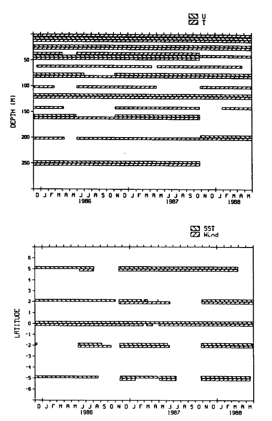
During boreal spring of each of the years considered the data coverage off the equator at 110°W was more extensive (Figure 1). These years provide interesting contrasts (Figure 2): spring 1986 was relatively normal, spring 1987 experienced the warmest eastern Pacific SST of the ENSO event, and in spring 1988 the subsequent cold event began. The enhanced data coverage from the off-equatorial mooring allows a more complete description of these periods and estimation of additional terms in the heat budget.
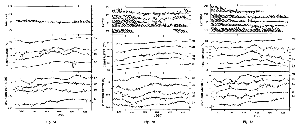
Figure 8 shows the wind, SST, and thermocline depth time series for the six month periods December though May of 1985-1986, 1986-1987, and 1987-1988. These periods are referred to below as 1986, 1987, and 1988. The wind time series are represented by arrows which point in the direction toward which the wind is blowing (north is toward the top of the page) and whose length is proportional to speed. These sticks are 3-day subsamples of the daily data which have been filtered with a 21-day Hanning low pass filter. Temperature and thermocline depth time series show both daily averaged (thin line) and 21-day Hanning low-pass-filtered (heavy line) data. The 18°C isotherm is used to represent the thermocline depth, since the 20°C isotherm surfaces at the equator in spring 1988 (Figure 2). Note that the temperature and depth scales are correct for the equatorial location. The time series of SST and 18°C depth at the other latitudes are offset by the amounts given in the figure caption.
Fig. 8. Time series of the winds, SST, and depth of the 18°C isotherm for
boreal spring of (a) 1986, (b) 1987, and ( c) 1988 at the
latitudes indicated along 110°W. Wind sticks point in the direction toward which
the wind is blowing. The length of the sticks is such that 20 m s is equivalent to the monthly tick marks on the time axis. For SST and 18°C depth,
the light line indicates the daily data and the heavy line indicates a 21-day
Hanning low-pass filter. The 5°S SST in 1986 is actually the 20-m temperature
record. The SST and 18°C depth scales are correct for the equatorial time series.
The SST time series at the other latitudes have been offset as follows: 5°N
and 2°N are offset by 6°C and 3°C for all 3 years shown, 2°S is offset by -3°C
in 1987 and by -6°C in 1988, and 5°S is offset by -6°C in 1986 and 1987 and
by -10°C in 1988. The 18°C time series offsets are the same in all years: 5°N
is offset by -125 m, 2°N by -50 m, 2°S by 50 m, and 5°S by 75 m.
is equivalent to the monthly tick marks on the time axis. For SST and 18°C depth,
the light line indicates the daily data and the heavy line indicates a 21-day
Hanning low-pass filter. The 5°S SST in 1986 is actually the 20-m temperature
record. The SST and 18°C depth scales are correct for the equatorial time series.
The SST time series at the other latitudes have been offset as follows: 5°N
and 2°N are offset by 6°C and 3°C for all 3 years shown, 2°S is offset by -3°C
in 1987 and by -6°C in 1988, and 5°S is offset by -6°C in 1986 and 1987 and
by -10°C in 1988. The 18°C time series offsets are the same in all years: 5°N
is offset by -125 m, 2°N by -50 m, 2°S by 50 m, and 5°S by 75 m.
The meridional distribution of SST change was similar in 1986 and 1987; however, the mean temperature was about 1.5°C warmer in 1987. Warming began in January and occurred nearly simultaneously at all latitudes sampled. Maximum temperature was in March-April, when SST near the equator was about 3°C higher than the December value. In 1988, the SST change south of 5°N was considerably more irregular than in the other 2 years. SST warmed in January-February but began to decrease in mid-March. Equatorial SST fell from a high of 27°C in March to 19°C in May. At 5°N the seasonal SST change was nearly normal.
Wind time series showed the seasonal movement of the intertropicl convergence zone (ITCZ) and the decrease in the Southeast trades near the equator. The wind vectors began turning first near 5°N and then moved towards the equator. In all years, periods of northerly winds occurred on the equator; in 1988 these winds extended to 2°S. In April-May of 1988, strongly divergent winds developed about the equator as the anomalously cool water appeared. Hayes et al. [1989b] suggest that this divergence was in part a response to the SST gradient.
Thermocline depth tended to decrease throughout the spring period of all years. This low-frequency trend was most apparent at 5°S, where warmest SST occurred while the thermocline was shoaling. Near the equator the monthly variability is more pronounced and there is little correlation of SST and thermocline variations on this time scale.
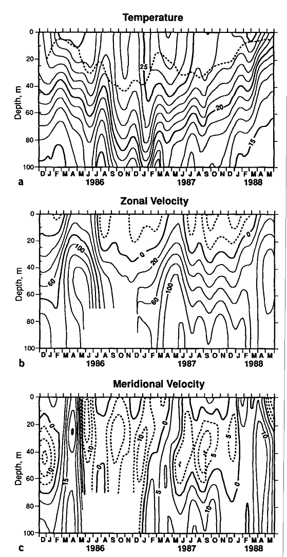
There was a pronounced deepening of the thermocline in January 1987 (about
50 m) which appears to be equatorially trapped. Empirical orthogonal function
(EOF) analysis [Davis,
1976] of the surface dynamic height time series derived from the moored
temperature measurements using a latitude dependent temperature-salinity relation
captured this equatorially symmetric variability in the first mode, which accounted
for 66% of the total variance. The meridional structure function for this mode
near the equator is well fit by the structure of a first baroclinic mode equatorial
Kelvin wave (Figure 9) assuming a phase speed
C = 2.1 m s [Hayes
and Halpern, 1984]. This Kelvin signal was noted in MH, who attributed
it to wind variability in the western Pacific in November-December. This interpretation
was supported by Delcroix
et al. [1991], who used Geosat satellite altimeter measurements to trace
this sea level signal across the Pacific. The signal is apparent in the variations
of the deeper zonal currents (e.g., 120 m current in Figure
10); however, the surface zonal velocity shows no indication of this event.
The weak surface signal is consistent with the effects of wave mean flow interactions
[McPhaden
et al., 1987] and with general circulation model (GCM) studies of the
propagation of Kelvin pulses [Geise
and Harrison, 1990].
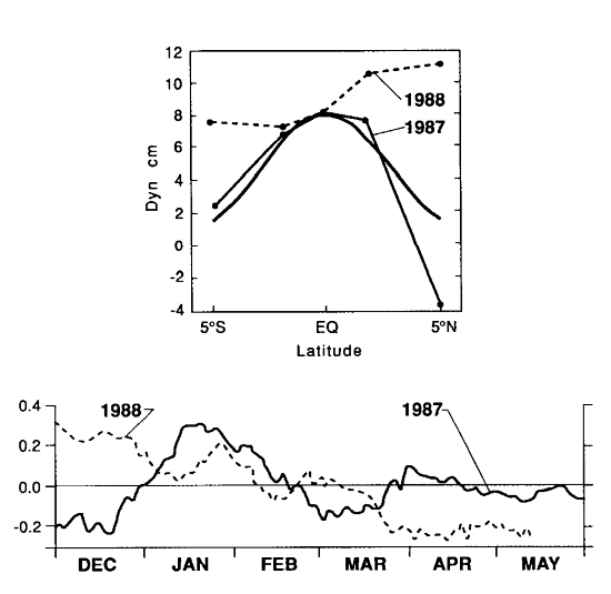
Fig. 9. Meridional structure functions and time series of the first EOF
of surface relative to 300 dbar dynamic height constructed from the temperature
time series along 110°W in 1987 and 1988. For comparison the meridional structure
of a first-vertical-mode equatorial Kelvin wave with a phase speed of 2.1 m
s is also shown.
In 1988 the 18°C isotherm rose about 75 m from December to May and nearly broke the surface. The mixed layer was very thin (Figure 5) or nonexistent. This shoaling was not trapped to the equator. The structure function of the first EOF (which explained 70% of the variance) of surface dynamic height relative to 300 dbar (Figure 9) was fairly uniform from 5°N to 5°S and the time series showed the sea level decrease which accompanied the thermocline rise. This drop in sea level was about 5 dyn cm at 5°N.
A prominent feature of the zonal surface current was the onset of eastward
surface current each year (Figure 10). Persistent
eastward flow began in mid-March, after SST had warmed. The systematic change
was confined to near the surface. There was not a consistent pattern at 120
m. Strongest eastward near surface zonal speed was in 1986 (about 50 cm s
in April), weakest was in 1987.
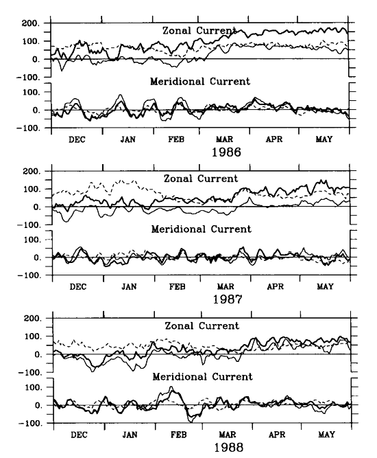
Fig. 10. Time series of zonal and meridional velocity on the equator at 110°W at depths of 10 m (light line), 45 m (heavy line), and 120 m (dashed line) for boreal spring of 1986, 1987, and 1988. Units of velocity are centimeters per second.
Meridional velocity exhibited the 20- to 30-day variability associated with the tropical instability oscillations in the eastern Pacific [Halpern et al., 1988]. This signal was most apparent in December-March 1986 and was again seen during this period in 1988. During the 1987 warm event the instability oscillations were weaker; this weakening was also noted during the 1982-1983 warm event [Philander et al., 1985].
Go back to previous section or forward to next section
Go back to Abstract