U.S. Dept. of Commerce / NOAA / OAR / PMEL / Publications
The measurements used in this study consist of wind, temperature, and current data from the locations and during the periods detailed in Figure 1. Data gaps of less than 2 weeks were filled by linear interpolation. Off the equator, only data during December to May of each year were used, and gaps in SST were filled using the data at 20-m depth. The equatorial instrumentation and processing procedures are discussed in MH. Off-equatorial measurements were collected by ATLAS wind and thermistor chain moorings. ATLAS is a taut wire surface mooring which measures wind (at 4 m above sea level), air temperature, SST (at 1 m depth), and 10 subsurface temperatures to a maximum depth of 500 m. All data are telemetered in real time via Service Argos. In the data sets used here the transmitted temperature data were all 24-hour averages; the wind averaging interval varied. However, in subsequent processing, all time series were reduced to daily averages. The ATLAS mooring and thermistor chain is discussed further by Milburn and McLain [1986] and Hayes et al. [1989a, 1991].
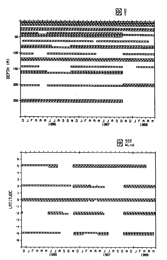
Fig. 1. Depths and locations of the time series used in this study. (Top) Record lengths of the velocity (u) and temperature (T) time series at 0°, 110°W. (Bottom) SST and wind record lengths at the measurement locations along 110°W. SST was measured at 1 m depth except at 5°S for January-August 1986, when the 20 m temperature record was used.
Time series of the equatorial data are shown in Figure 2. The monthly average climatology shown in this figure was computed from the mooring time series as described in MH. Warmest SST (28.5°C) occurred in April 1987; the largest positive anomaly was in September 1987 (3.4°C). Throughout the period September 1986 to February 1988, SST was above normal. Then from March to May 1988, SST dropped by nearly 8°C; the ENSO warm event had ended and a cold event began. This shift from warm to cold was much more dramatic than the onset of the warm period.
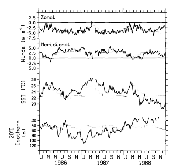
Fig. 2. Time series of zonal and meridional surface wind, SST, and depth of the 20°C isotherm at 0°, 110°W for the 3 years 1986-1988. Solid lines are the measured values, and dotted lines are the monthly mean climatological values based on the historical data from the mooring at this location [McPhaden and Hayes, 1990].
Surface wind tended to follow the annual cycle throughout the study period. Meridional winds were anomalously strong the last half of 1986 and through 1987. Zonal winds were also stronger than normal in much of 1987. The onset of cooler than normal conditions in 1988 was accompanied by normal zonal and weaker than normal meridional winds. MH note that this pattern of surface wind is consistent with the analysis of climatological data [Wallace et al., 1989] which shows that near the equator the southeast trades in the eastern Pacific are stronger than normal during ENSO warm events. Wallace et al. [1989] attribute this result to reduced atmospheric boundary layer stratification and shear when SST exceeds surface air temperature.
Thermocline depth as represented by the 20°C isotherm in Figure 2 tends to mirror SST on interannual time scales. The thermocline was anomalously deep for about 1 year beginning in September 1987, when SST was anomalously warm. The shallowest thermocline was in 1988 when SST was anomalously cool. However, higher-frequency correlations between SST and 20°C depth are not so apparent. There are several examples of large-amplitude changes in 20°C depth which are not seen in SST (e.g., the January 1987 deepening), and the seasonal cycle in SST was not observed in thermocline depth.
Seasonal and lower-frequency variability was examined by low-pass filtering the time series with a 91-day Hanning filter. This filter has a zero at 45 days and passes 50% of the variance at 91 days. On seasonal time scales the correlations among SST, surface wind speed, and total surface heat flux from the atmosphere to the ocean (estimated as discussed in section 3) are apparent in Figure 3 where the time series with the mean value removed are plotted. SST and surface wind speed tend to be out of phase. Net surface heat flux tends to mirror the surface wind speed. Hence warmest SST and largest surface heat flux occur nearly simultaneously each year. This result implies that oceanic processes must be important in the heat budget of the surface waters in the eastern equatorial Pacific. Otherwise, surface heat flux and SST change (rather than SST) would be in phase. The oceanic processes and their estimation from the moored array data are discussed in the next section.
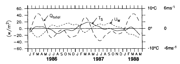
Fig. 3. Low-pass-filtered (91-day Hanning filter) time series of the SST
(T , solid line), surface
wind speed (U
, solid line), surface
wind speed (U , short-dashed
line), and total surface heat flux (Q
, short-dashed
line), and total surface heat flux (Q ,
long-dashed line, see text) at 0°, 110°W for the period indicated. The mean
value has been removed from each series prior to plotting. Scales for Q
are on the left-hand axis; T
and U are indicated on
the right.
,
long-dashed line, see text) at 0°, 110°W for the period indicated. The mean
value has been removed from each series prior to plotting. Scales for Q
are on the left-hand axis; T
and U are indicated on
the right.
Go back to previous section or forward to next section
Go back to Abstract