U.S. Dept. of Commerce / NOAA / OAR / PMEL / Publications
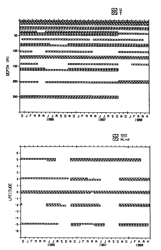
Figure 1. Depths and locations of the time series used in this study. (Top) Record lengths of the velocity (u) and temperature (T) time series at 0°, 110°W. (Bottom) SST and wind record lengths at the measurement locations along 110°W. SST was measured at 1 m depth except at 5°S for January-August 1986, when the 20 m temperature record was used.
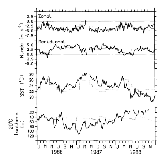
Fig. 2. Time series of zonal and meridional surface wind, SST, and depth of the 20°C isotherm at 0°, 110°W for the 3 years 1986-1988. Solid lines are the measured values, and dotted lines are the monthly mean climatological values based on the historical data from the mooring at this location [McPhaden and Hayes, 1990].
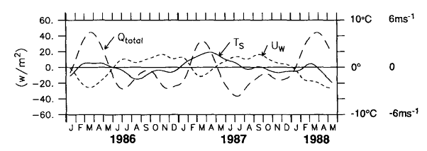
Figure 3. Low-pass-filtered (91-day Hanning filter) time series of the SST (T , solid line), surface wind speed (U
 , short-dashed line), and total surface heat flux
(Q
, short-dashed line), and total surface heat flux
(Q , long-dashed line, see text) at
0°, 110°W for the period indicated. The mean value has been removed from each series
prior to plotting. Scales for Q are
on the left-hand axis; T and U are indicated on the right.
, long-dashed line, see text) at
0°, 110°W for the period indicated. The mean value has been removed from each series
prior to plotting. Scales for Q are
on the left-hand axis; T and U are indicated on the right.
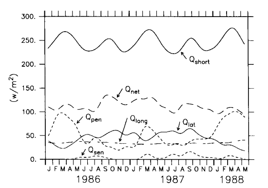
Figure 4. Components of the surface heat flux (see equation (1)).
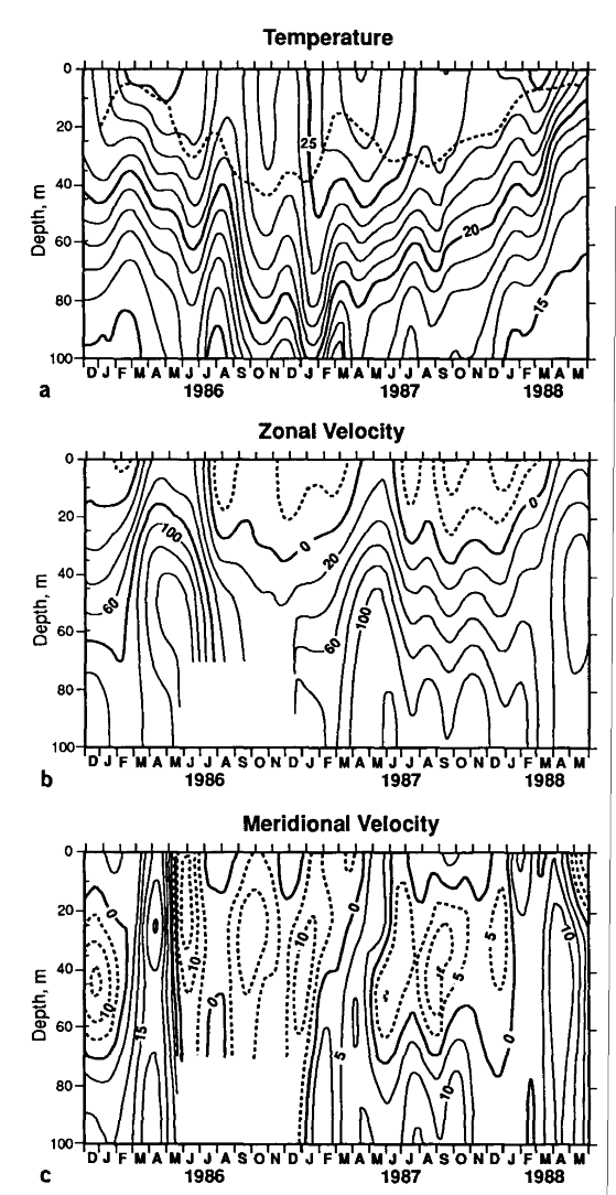
Figure 5. Contour plots of (a) isotherm depth (contours are in degrees
Celsius), (b) zonal velocity (centimeters per second), and (c) meridional
velocity (centimeters per second) in the upper 100 m at 0°, 110°W, based on the 91-day
low-pass-filtered time series. The dashed line superimposed on the isotherm contours
indicates the mixed layer depth computed as discussed in the text. Contour intervals are
1°C, 20 cm s , and 5 cm s for temperature, zonal velocity, and meridional velocity,
respectively.
, and 5 cm s for temperature, zonal velocity, and meridional velocity,
respectively.
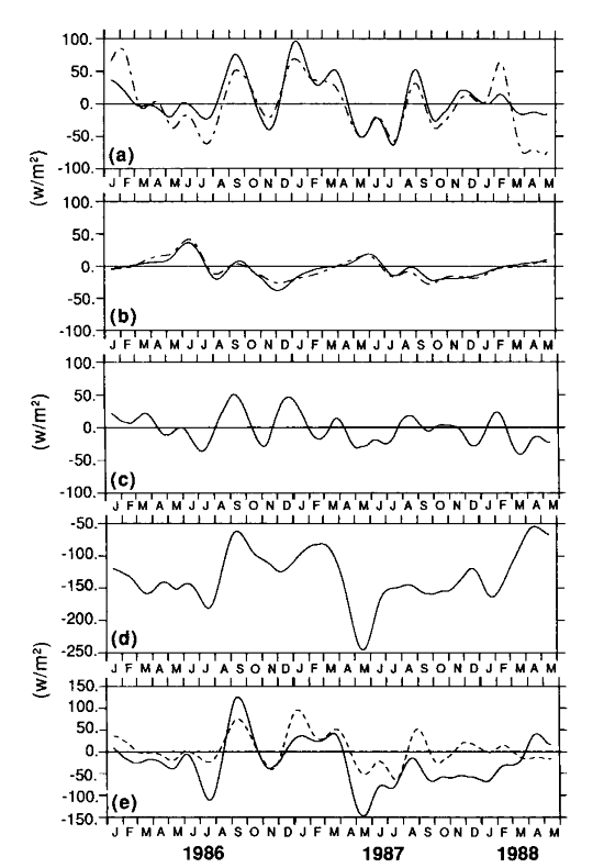
Figure 6. Time series plots of various terms in equation (1). All time series have
been low pass filtered with a 91-day Hanning filter. (a) Change in the mixed layer
heat content, Q ; the solid line was
computed with variable h
; the solid line was
computed with variable h , and the
dashed line has a constant h = 25 m.
(b) Zonal advective heat flux, Q
, and the
dashed line has a constant h = 25 m.
(b) Zonal advective heat flux, Q ; the solid line was computed with
  T/x estimated
from moorings at 110°W and 140°W, dashed line assumes a constant
T/x estimated
from moorings at 110°W and 140°W, dashed line assumes a constant ![]() . (c) Vertical entrainment, Q. (d) Vertical diffusive heat flux, Q
. (c) Vertical entrainment, Q. (d) Vertical diffusive heat flux, Q . (e) Superposition of Q (dashed line) and Q
 (solid line) as defined in the text.
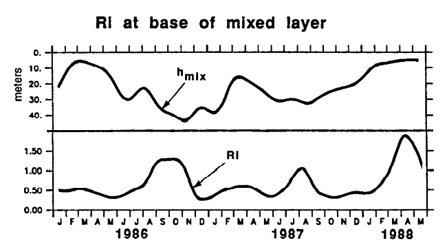
Figure 7. Low-pass-filtered (91-day Hanning filter) time series of the mixed layer
depth h and Richardson number Ri
at the base of the mixed layer at 0°, 110°W, estimated as described in the text.
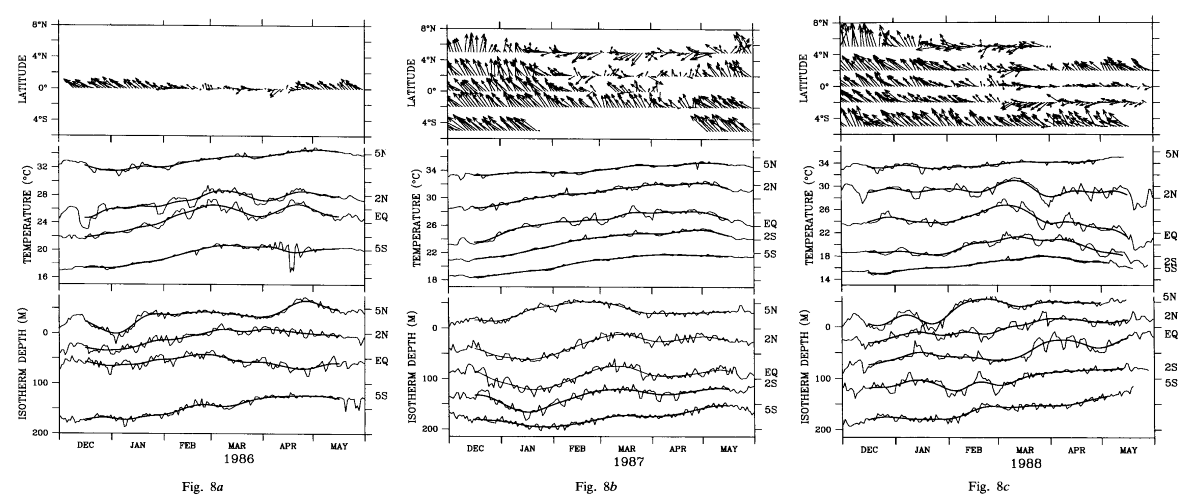
Figure 8. Time series of the winds, SST, and depth of the 18°C isotherm for boreal
spring of (a) 1986, (b) 1987, and (c) 1988 at the latitudes indicated
along 110°W. Wind sticks point in the direction toward which the wind is blowing. The
length of the sticks is such that 20 m s is equivalent
to the monthly tick marks on the time axis. For SST and 18°C depth, the light line
indicates the daily data and the heavy line indicates a 21-day Hanning low-pass filter.
The 5°S SST in 1986 is actually the 20-m temperature record. The SST and 18°C depth
scales are correct for the equatorial time series. The SST time series at the other
latitudes have been offset as follows: 5°N and 2°N are offset by 6°C and 3°C for all 3
years shown, 2°S is offset by -3°C in 1987 and by -6°C in 1988, and 5°S is offset by
-6°C in 1986 and 1987 and by -10°C in 1988. The 18°C time series offsets are the same
in all years: 5°N is offset by -125 m, 2°N by -50 m, 2°S by 50 m, and 5°S by 75 m.
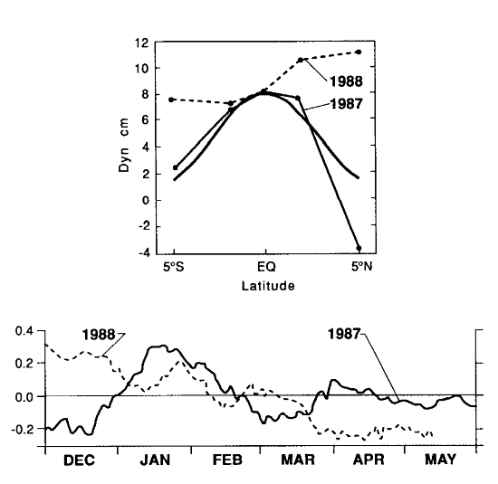
Figure 9. Meridional structure functions and time series of the first EOF of surface
relative to 300 dbar dynamic height constructed from the temperature time series along
110°W in 1987 and 1988. For comparison the meridional structure of a first-vertical-mode
equatorial Kelvin wave with a phase speed of 2.1 m s
is also shown.
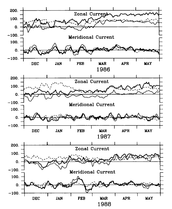
Figure 10. Time series of zonal and meridional velocity on the equator at 110°W at depths of 10 m (light line), 45 m (heavy line), and 120 m (dashed line) for boreal spring of 1986, 1987, and 1988. Units of velocity are centimeters per second.
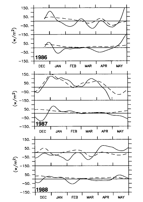
Figure 11. The top panel for each year shows time series (45-day low-pass Hanning
filter) of Q (dashed) and Q (solid; see text for definition).
The bottom panel for each year shows meridional diffusive heat flux Q
(solid; see text for definition).
The bottom panel for each year shows meridional diffusive heat flux Q (dashed) and meridional advective heat flux Q
 (solid). Records for boreal spring 1986, 1987,
and 1988 are shown.
(solid). Records for boreal spring 1986, 1987,
and 1988 are shown.
Go back to previous section
Go back to Abstract