U.S. Dept. of Commerce / NOAA / OAR / PMEL
/ Publications
Recent eruptions on the CoAxial segment of the Juan de Fuca Ridge:
Implications for mid-ocean ridge accretion processes
R. W. Embley,1 W. W. Chadwick,2 M. R. Perfit,3
M. C. Smith,3 and J. R. Delaney4
1Pacific Marine Environmental Laboratory, National Oceanic
and Atmospheric Administration, Hatfield Marine Science Center, Newport, Oregon
97365
2Cooperative Institute for Marine Resources Studies, Oregon State
University, Hatfield Marine Science Center, Newport, Oregon 97365
3Department of Geology, University of Florida, Gainesville, Florida,
32611
4School of Oceanography, University of Washington, Seattle, WA 98195
Journal of Geophysical Research, 105(B7),
16,501–16,525 (2000).
Copyright ©2000 by the American Geophysical Union. Further electronic distribution
is not allowed.
1. Introduction
The realization in the 1960s that the world-encircling mid-ocean ridge (MOR)
generates most of the Earth's volcanic activity has led to an increasing focus
on this system with progressively more powerful mapping systems [Detrick,
1986]. Although the scale of the feature (~60,000 km) and its relative
remoteness have been impediments to a comprehensive study, the combination of
digital swath mapping bathymetric and side-scan sonar systems, detailed MOR
basalt (MORB) geochemical analyses, common depth point seismic profiling, and
the use of deep-towed cameras and submersibles have resulted in significant
progress during the last 2 decades in defining the major volcanic and tectonic
"units" of the system [Detrick
et al., 1987; Lonsdale,
1977; Macdonald
and Fox, 1983; Sempere
et al., 1993] and in understanding some of the fundamental accretionary
processes which occur at the ridge crest [Ballard
et al., 1979; Kappel
and Ryan, 1986; Macdonald
and Fox, 1983; Tucholke
and Lin, 1994]. Although these studies have provided good definition
of long-term (~10 –10
–10 years) patterns of crustal accretion and the tectonic framework of the oceanic
crust, a detailed understanding of the temporal and spatial dynamics of MOR
magmatism has been lacking. Unlike terrestrial volcanic areas, many of which
are closely monitored with local seismic arrays capable of detecting and locating
volcanogenic seismic events (M < 4), most of the MOR is monitored
solely by the worldwide seismic net, which is limited to a detection threshold
of M
years) patterns of crustal accretion and the tectonic framework of the oceanic
crust, a detailed understanding of the temporal and spatial dynamics of MOR
magmatism has been lacking. Unlike terrestrial volcanic areas, many of which
are closely monitored with local seismic arrays capable of detecting and locating
volcanogenic seismic events (M < 4), most of the MOR is monitored
solely by the worldwide seismic net, which is limited to a detection threshold
of M  4 [Fox,
1993/1994].
4 [Fox,
1993/1994].
The first significant data about processes associated with discrete accretion
events along the fast and intermediate spreading rate portions of the MOR
became available from studies of sites on the Juan de Fuca Ridge (JdFR)
and northern East Pacific Rise through the serendipitous discovery of seafloor
eruptions [Chadwick
et al., 1991; Embley
et al., 1991; Haymon
et al., 1993]. Detection of volcanic events on the Juan de Fuca
and Gorda Ridges became possible in 1991 when the U.S. Navy allowed the National
Oceanic and Atmospheric Administration (NOAA) access to the Sound Surveillance
System (SOSUS) submarine hydrophone arrays in the northeast Pacific. The high
efficiency of sound propagation in seawater in the Sound Fixing and Ranging
(SOFAR) channel of the upper ocean lowers the detection threshold by about 2
orders of magnitude and increases the location precision by about 1 order of
magnitude, making possible remote detection of, and subsequent response to,
volcanic events in this area [Fox,
1993/1994]. As of late 1999, three eruptions on northeast Pacific
spreading centers have been detected with this method and verified in the field
[Dziak
and Fox, 1999; Dziak
et al., 1995; Fox
and Dziak, 1998]. The first one was at the CoAxial segment in
1993.
In June 1993, within a week after the real-time acoustic monitoring system
became operational, an unusual seismic swarm began on the northern part of JdFR
just north of Axial Volcano (Figure 1) [Fox
et al., 1995]. The swarm initially migrated north along the ridge
axis for at least 25 km [Dziak
et al., 1995] to the northern (deeper) end of the segment, where
it subsequently became concentrated at approximately the center of the axial
valley at 46°31 N [Embley
et al., 1995] (Figure 1). The
only known eruption associated with the 1993 event occurs within this cluster
of seismicity [Embley
et al., 1995] (Figure 1). Several
rapid response cruises took place between July and October 1993 and included
water column plume surveys from the research vessels Tully, Discoverer,
and Atlantis II, dives with the Remotely Operated Platform for Ocean
Science (ROPOS) and manned submersible Alvin, and near-bottom
surveys with the Scripps Deep-Tow and a U.S. Geological Survey (USGS) towed
camera system. The details of the 1993 seismic swarm and the initial documentation
of the water column and seafloor manifestation of the diking/eruption episode
have previously been described in a series of papers [e.g., Fox,
1995].
N [Embley
et al., 1995] (Figure 1). The
only known eruption associated with the 1993 event occurs within this cluster
of seismicity [Embley
et al., 1995] (Figure 1). Several
rapid response cruises took place between July and October 1993 and included
water column plume surveys from the research vessels Tully, Discoverer,
and Atlantis II, dives with the Remotely Operated Platform for Ocean
Science (ROPOS) and manned submersible Alvin, and near-bottom
surveys with the Scripps Deep-Tow and a U.S. Geological Survey (USGS) towed
camera system. The details of the 1993 seismic swarm and the initial documentation
of the water column and seafloor manifestation of the diking/eruption episode
have previously been described in a series of papers [e.g., Fox,
1995].
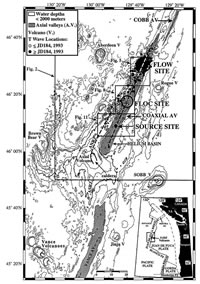
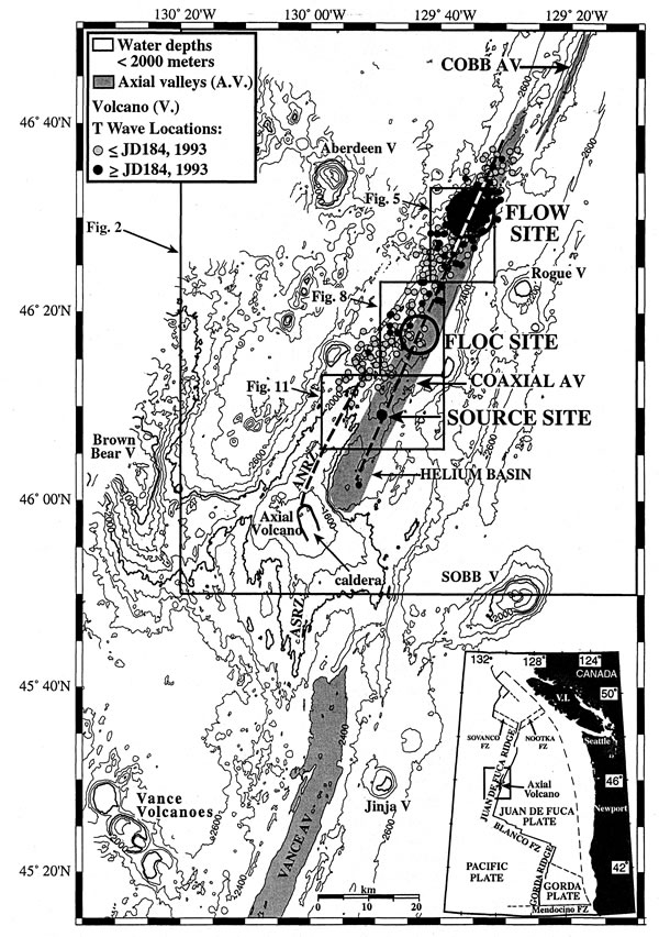
Figure 1. Location map of central Juan de Fuca Ridge with place names used
in text. Inset at bottom right corner shows location of area relative to northwest
United States and Canada. AV is abbreviation for Axial Valley, V is for Volcano,
and FZ is for fracture zone. Location of epicenters from June–July 1993
seismic swarms. Dashed lines show trends of Axial Volcano North Rift Zone (AVNRZ)
and CoAxial neovolcanic zone. Diameters of circles are approximate length along
axis of venting as observed in 1993. Contour interval is 200 m. Boxes outline
areas covered by Figures 2, 5,
8, and 11.
The initial data sets generated several intriguing questions that have major
implications not only for this particular event but also for the nature of MOR
crustal accretion. An important first-order question was: Where did the dike
come from? The tertiary water-borne seismic wave (T wave) epicenters
were initially located west of CoAxial's axial valley, and the activity was
originally thought to have begun on the north rift zone of Axial Volcano, which
overlaps with the southern part of the CoAxial segment (Figure
1). However, the fresh lava and the active hydrothermal sites discovered
during the 1993 cruises were aligned along the neovolcanic zone of CoAxial,
with no indication that Axial had been involved. Water column and bottom
surveys during the 1993 cruises localized three discrete venting sites (Flow
site, Floc site, Source site) which were separated by 15–20 km from one
another (Figure 1). So, a second question was:
What was the geologic and hydrothermal manifestation of the event along
the path of dike injection? Detailed seafloor mapping of the segment and time
series measurements at these vent sites over several years subsequent to the
diking event have helped us interpret what parts of the segment were perturbed
by this event and which were unaffected. A third question was: Was the dike
an isolated event or part of a longer-lasting episode of crustal accretion for
this section of ridge? On the central volcanos of Iceland (our closest subaerial
analogy to the MOR), stress builds up over long periods of time (hundreds of
years) and is released during multiple events that occur on a decadal time scale
[Björnsson,
1985], but until now, there has not been an analogous record of crustal
accretion observations anywhere on the submerged portion of the MOR.
To answer these questions, the initial event response expeditions were followed
by several other surface ship and submersible cruises in 1993–1996. Submersible
dives in 1994–1995 continued the chemical and biological time series studies
at the vent sites discovered in 1993 and conducted detailed mapping of
the sites. A segment-scale mapping program in 1994–1996 used deep-towed
side-scan sonar surveys, camera tows, and rock coring along the CoAxial neovolcanic
zone and the north rift zone of Axial Volcano in order to place the detailed
work at the active vent sites into a regional context.
This paper synthesizes the available SeaBeam, side-scan, towed camera, and
submersible data to relate the 1993 CoAxial accretion event to the recent
structural and magmatic history of the area and to the broader issue of MOR
accretion processes. We believe our data demonstrate that (1) the 1993 dike
intruded from a magma source beneath the CoAxial segment (rather than Axial
Volcano) with a significant component of lateral propagation along the neovolcanic
zone of the segment, and (2) the 1993 eruption was not an isolated event but
was one of at least three volcanic events in the 12-year period between
1981 and 1993 which must have relieved a significant level of stress along the
segment.
2. Sources of Data
2.1. Multibeam Bathymetry
The initial SeaBeam surveys of the axis of the Juan de Fuca Ridge were collected
in 1981–1982 on the NOAA ship Surveyor and were navigated by Loran-C,
which provided good relative positioning for swath matching but only approximate
geodetic control. These data were subsequently shifted to geodetic "space" using
Transit satellite fixes taken during the original surveys. Following the 1990
discovery of the young eruptive mounds on the southern Juan de Fuca Ridge [Chadwick
et al., 1991; Fox
et al., 1992] another survey of the entire neovolcanic zone of
the Juan de Fuca Ridge was made from the NOAA ship Discoverer in 1991.
A third survey with GPS navigation over the northern portion of Axial
Volcano and the CoAxial segment was made immediately after the 1993 eruption.
These three surveys were the basis for the SeaBeam differencing calculations
presented by Chadwick
et al. [1995]. The database used for the SeaBeam base maps in
this manuscript is a combination of the older Loran-C/Transit navigated data
and the 1993 GPS survey.
2.2. Side-Scan Sonar
Data from two types of side-scan sonar systems, SeaMARC II and AMS-60,
are used in this study to provide an excellent regional structural context
within which to view higher-resolution data sets. The SeaMARC II system is a
surface-towed side-scan sonar system operating at 12 kHz. The SeaMARC II data
used in this study were collected in 1983 and 1985 by the Canadian Pacific Geoscience
Center, the USGS, the University of Washington, and the University of Hawaii.
These surveys were navigated by Loran-C and Transit satellite fixes. In 1996,
comprehensive surveys of the neovolcanic zone of CoAxial and the north rift
zone of Axial Volcano were made using an AMS-60 (60 kHz) deep-towed side-scan
operated by Williamson and Co., Seattle, Washington, towed from the NOAA ship
Discoverer. The position of the side-scan sonar was calculated using
the setback of the towfish from depth, wire out, and the GPS position of the
ship. The AMS-60 side-scan data were processed to a resolution of 1 m using
the USGS Mini Image Processing System (MIPS) software. The AMS-60 side-scan
data provides information on the morphology, structure, and texture of the seafloor
and can be used to distinguish young volcanic terrain from older tectonized
seafloor.
2.3. Submersible and Camera Tow Data
These data were collected using the NOAA Pacific Marine Environmental Laboratory
(PMEL) and the USGS deep-towed camera systems (1993–1994), ROPOS
(1993), and the manned submersible Alvin (1993–1995). The ROPOS
and Alvin data used in this paper include video and still photographs
and microbathymetry (derived from adding the pressure depth and altimeter
output). The deep-towed camera data consist of color 35-mm film, color video,
and temperature from the USGS system and monochrome video, color 35-mm film,
temperature, and microbathymetry from the NOAA camera system. The seafloor images
were digitized and characterized according to the scheme of Fox
et al. [1988]. All of the Alvin dives and most of the
deep-towed camera data were collected within long-baseline transponder nets
that provide a positional accuracy of ~20 m. These near-bottom observations
were used to delineate the location of the neovolcanic zone on both the CoAxial
segment and the north rift zone of Axial Volcano.
3. The Structural and Volcanological Context of the Central Juan de Fuca Ridge
The Juan de Fuca Ridge extends from the Blanco Fracture Zone at 44°30N
northward to the Sovanco Fracture Zone at 48°45N
(Figure 1). General descriptions of the ridge
and its various segments have been published previously [Crane
et al., 1985; Delaney
et al., 1981; Embley
and Chadwick, 1994; Embley
et al., 1990; Johnson
and Holmes, 1989; Kappel
and Normark, 1987; Kappel
and Ryan, 1986]. The dominant morphologic feature on the Juan
de Fuca Ridge is the anomalously shallow edifice of Axial Volcano, the youngest
in a series of volcanos generated by the Cobb-Eickelberg hotspot [Desonie
and Duncan, 1990] (Figure 1).
The general characteristics of the Axial Volcano segment have been described
by Delaney
et al. [1981], Johnson
and Holmes [1989], Johnson
and Embley [1990], Appelgate
[1990], and Embley
et al. [1990]. The bulk of the volcanic edifice lies between
about 45°30N and 46°20N
and consists of a summit plateau and caldera centered at 45°55N,
130°00W, two major rift zones around
the caldera, and several other smaller plateaus and volcanic rift zones and
ridges (Figures 1 and 2
and Plate 1). Axial Volcano and its major rift
zones probably overlie the spreading axis between the Vance and CoAxial segments
[Delaney
et al., 1981].
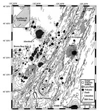
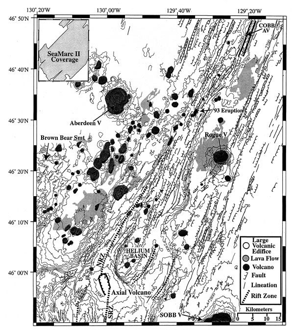
Figure 2. Interpretative map of Axial Volcano and CoAxial segment based
on SeaMARC II side-scan sonar and side-lit SeaBeam bathymetry. Dark shaded areas
are major off-axis volcanos, medium shaded zones are high backscatter areas
marking most recent off-axis lava flows, and light shaded zone marks approximate
limit of major hotspot edifices of Axial Volcano and Brown Bear Seamount to
the east. Faults are hachured. SeaBeam contours are lightly shaded and their
limit marks limit of SeaBeam coverage. Coverage of SeaMARC II side-scan sonar
surveys in 1983 and 1984 are shown in inset. SRZ is south rift zone, NRZ is
north rift zone, SOBB is Son of Brown Bear Volcano.
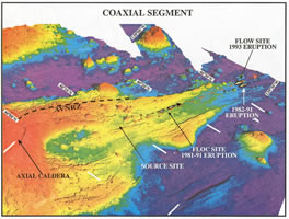
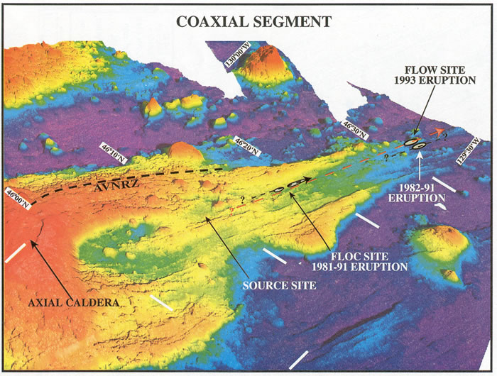
Plate 1. Perspective side-lit SeaBeam bathymetry of CoAxial segment of Juan
de Fuca Ridge with locations of major features discussed in text. View is looking
northwest from eastern side of Axial Volcano. Latitudes and longitudes are only
approximate because of foreshortening of image. Dashed lines with arrows are
orientations and extent of diking based on geologic evidence for 1993 (red)
and 1981–93 dikes.
To better understand the segmentation of the ridge in this complex area, we
constructed a structural map based on the SeaBeam bathymetry and SeaMARC II
side-scan data (Figure 2). In older maps based
on these data [Davis
and Currie, 1993; Johnson
and Holmes, 1989] the Axial Volcano North Rift Zone (AVNRZ) overlaps
with the Cobb segment beginning at about 46°40N
and what is now known as the CoAxial segment was not recognized as an active
spreading segment. However, the CoAxial segment is clearly delineated as a separate
spreading segment by inward facing faults between 46°00N
and 46°40N (Figures
2, 3a, and 3b). These faults structurally
define an axial valley that is between 3 and 5 km in width with up to 150
m of relief. The southern portion of the CoAxial segment overlaps with the AVNRZ
for at least 25 km (46°00–15N),
and the northern end of CoAxial segment overlaps with the southern portion
of the Cobb segment by 10 km. The southern end of the CoAxial valley was named
"Helium Basin" because of the unusually high  (
( He)%
found in hydrothermal plumes from this area in the early 1980s [Lupton,
1990].
He)%
found in hydrothermal plumes from this area in the early 1980s [Lupton,
1990].
Most of the faults digitized from the SeaMARC II and SeaBeam data are oriented
at or close to the trend of the Juan de Fuca Ridge (~N020°E), but oblique
or curvilinear ridges occur at several locations. Curvilinear constructional
volcanic ridges occur on the eastern side of the AVNRZ and at the southern and
northern ends of the CoAxial segment where it overlaps with the AVNRZ and the
Cobb segment, respectively. These curvilinear ridges are interpreted to be formed
by crack interaction between overlapping spreading segments such as those described
at faster spreading centers [Macdonald
and Fox, 1983; Sempere
and Macdonald, 1986]. A set of oblique ridges on older crust
found northeast of Axial Volcano (Figure 2) could
be traces of an older overlapping zone.
A striking feature in Figure 2 is the asymmetric
distribution of volcanic cones and lava flows on the west side of the ridge
and the concomitant apparent lack of faulting. Sediment cover is thinner on
the west side of the ridge because the ridge blocks the sediments from the continent,
so this asymmetry in faulting is not caused by sediment cover. It is probably
due either to burial of the faults by more active off-axis volcanism and/or
because faulting has been less developed on the west side, possibly due to the
shoaling of isotherms in the vicinity of the hotspot. Although there are a few
large volcanoes on the east flank of the ridge axis, most of the recent off-axis
lava flows are confined to the flank of Axial Volcano and Rogue Volcano. An
exception is one isolated but well-defined off-axis lava flow at 46°40N,
129°20W (Figure
2).
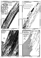
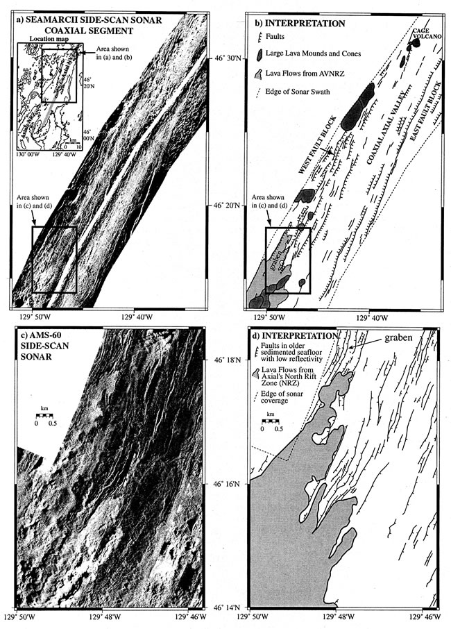
Figure 3. (a) Sea MARC II swath of Coaxial segment and (b) interpretation.
Note distinct graben containing northernmost young lavas. (c) AMS-60 side-scan
mosaic of junction of AVNRZ and CoAxial axial valley and (d) interpretation.
Note high backscatter lavas erupted along AVNRZ covering older (lower backscatter)
fissured lavas.
4. CoAxial Segment and Its Relation to Axial Volcano
The neovolcanic zone of a ridge segment is the narrow zone within which recent
volcanic eruptions have been focused; it is essentially the present axis of
accretion and spreading. Although the exact location of the neovolcanic zone
along the CoAxial segment and the AVNRZ is not always clear from bathymetry
alone, it is well-defined from a combination of side-scan and camera data.
The CoAxial segment extends from the Helium Basin at the base of the steep
northeast flank of Axial Volcano (~46°00N;
129°57W) to about 46°40N
where it overlaps with the southern end of the Cobb segment (Figures
1 and 2). The shoalest portion of the neovolcanic
zone of the CoAxial segment lies between 46°03N
and 46°15N along a ridge that bisects
the bowl-shaped Helium Basin. The segment deepens to the northeast by 425 m
over 60 km, from 2125 m at 46°08N
to 2550 m at 46°40N. This relatively
steep topographic gradient probably reflects a decrease of the long-term magma
supply away from the hotspot.
Morphology of the neovolcanic zone along the CoAxial segment exhibits considerable
along-strike variability (Figure 2 and Plate
1). The southern portion of the axial valley (46°00–15N)
contains a series of prominent ridges and conical volcanoes. From about 46°15N
to 46°30N, the center of the axial valley
consists of an alternating series of low-relief depressions, small volcanos,
and ridges with no well-defined central neovolcanic ridge. North of 46°30N,
a series of narrow volcanic ridges are again prominent. These curve eastward
in the overlap zone with the Cobb segment north of about 46°33N.
Small circular volcanic cones (<1 km in diameter) are found within the axial
valley for its entire length, but most of the largest cones lie along the southern
portion of the segment.
Between 46°12N and 46°25N
the CoAxial segment is bounded on both the west and east sides by large, fault-bounded
ridges, which have outlines in map view like two halves of a pear split along
the axis of the segment (Figure 2 and Plate
1). We interpret that these "fault-block ridges" initially formed on-axis
at CoAxial by magmatic processes and were then split apart by subsequent plate
spreading, as in the model proposed by Kappel
and Ryan [1986] for the southern JdFR. The western fault-block
ridge physically abuts, and is aligned with, the AVNRZ to the south. Some investigators
[Sohn
et al., 1997] have assumed that the western fault-block ridge
is an extension of the AVNRZ and therefore that the T wave epicenters
tracked the 1993 dike as it intruded from AVNRZ to the eruption site on the
CoAxial segment. However, side-scan, towed camera, and geochemical data show
that this would have been unprecedented. Those data clearly show that the lavas
erupted from the AVNRZ do not extend farther north than about 46°18N.
South of this boundary, the hummocky morphology of constructional volcanism
is clearly present in the side-scan imagery (Figures
2, 3a, and 3c),
young lavas are photographed in camera tows, and the lavas have a geochemical
affinity with basalts recovered from Axial Volcano [Smith,
1999; Smith
et al., 1997]. North of this boundary, the recent volcanism abruptly
ends and gives way to much older seafloor with numerous fissures and faults
and a lower acoustic backscatter value (Figure 3a,
3b, 3c, and 3d) probably caused by increased sediment cover of up to 80–100%
in this area as seen on bottom photos. The northern termination of young lavas
from AVNRZ occurs within a 3-km-wide graben extending from 46°16N
to 46°19N that bisects the top of the
western fault block ridge (Figure 3).
Our interpretation of these relationships is that the AVNRZ and CoAxial segment
behave as separate but overlapping ridge segments, with separate shallow magma
supplies, and the young volcanic constructions of the AVNRZ have been superimposed
upon the older western fault block ridge.
Geochemical data are key to evaluating the level of interaction between the
neovolcanic zones of Axial Volcano and the CoAxial segment. Isotropic ratios
are one of the most effective tools for discriminating different parental magmas
and their mantle sources because of their geochemical transparency to melting
and most shallow level crustal processes. Assuming crustal assimilation has
been negligible, significant differences in radiogenic isotopic ratios (e.g.,
87Sr/86Sr and 143Nd/144Nd) of two basalts
indicate that their mantle sources were different [Rogers
and Hawkesworth, 1999]. However, covariation between incompatible
element abundances and isotopic ratios in MORB from many portions of the MOR,
including the JDFR, suggests that some of the isotopic variability is a consequence
of mixing of melts from distinct mantle domains (i.e., enriched versus depleted)
or that it is a result of variable extents of melting of heterogeneous mantle
[White
et al., 1987]. Although the Sr and Nd isotopic values of MORB
from the JdFR do not vary much in comparison to other MOR segments affected
by hot spots, the data allow us to distinguish a few spatial domains along the
length of the JdFR. In particular, MORB from the CoAxial segment have distinctly
non-radiogenic  Sr/
Sr/ Sr
and 143Nd/144Nd, suggesting they were derived from long-term
depleted mantle that has not been recently "enriched" by another component.
A plot of Sr/Sr
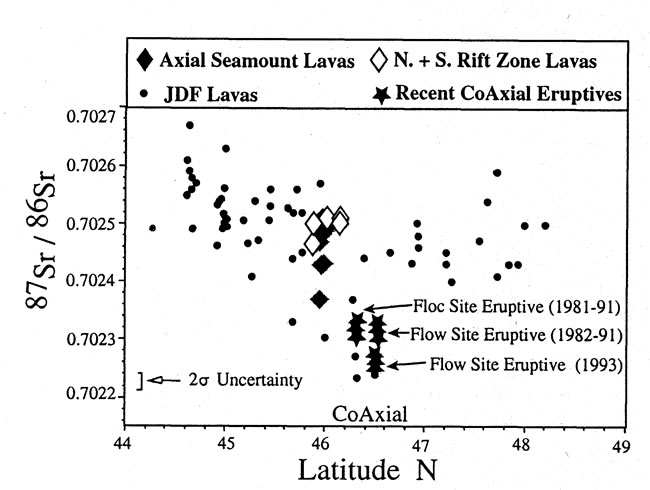
of basalts against latitude (Figure 4) reveals
that the recent source for the CoAxial segment is geochemically distinct from
both Axial Volcano and the rest of the JdFR. This distinction is particularly
clear when comparing the youngest samples from the AVNRZ and CoAxial segment.
The lack of any overlap between the fields that encompass the CoAxial segment
and Axial Volcano/AVNRZ provide compelling evidence that the magmatic plumbing
systems beneath Axial Volcano and the CoAxial segment are separate and that
although these ridge segments overlap, they do not interact magmatically.
Sr
and 143Nd/144Nd, suggesting they were derived from long-term
depleted mantle that has not been recently "enriched" by another component.
A plot of Sr/Sr
of basalts against latitude (Figure 4) reveals
that the recent source for the CoAxial segment is geochemically distinct from
both Axial Volcano and the rest of the JdFR. This distinction is particularly
clear when comparing the youngest samples from the AVNRZ and CoAxial segment.
The lack of any overlap between the fields that encompass the CoAxial segment
and Axial Volcano/AVNRZ provide compelling evidence that the magmatic plumbing
systems beneath Axial Volcano and the CoAxial segment are separate and that
although these ridge segments overlap, they do not interact magmatically.

Figure 4. Sr isotopes versus latitude, central Juan de Fuca Ridge.
5. The 1993 Eruption Site ("Flow Site")
The dives made at the 1993 eruption site ("Flow site") with the ROPOS
and the submersible Alvin mapped out the extent of the fresh lava flow
and diffuse hydrothermal venting associated with a zone of fissures and narrow
grabens extending several kilometers to its north and south [Chadwick
et al., 1995; Embley
et al., 1995] (Figures 5, 6,
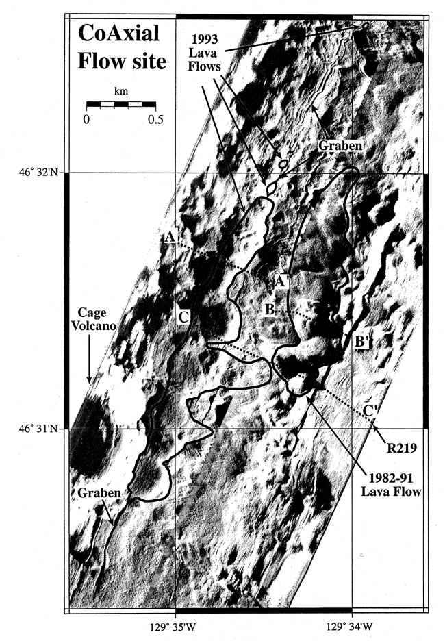
and 7). The eruption took place along an older
volcanic ridge that extends north of Cage Volcano, a prominent 1-km diameter
volcanic cone (Figure 6).
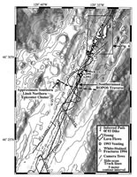
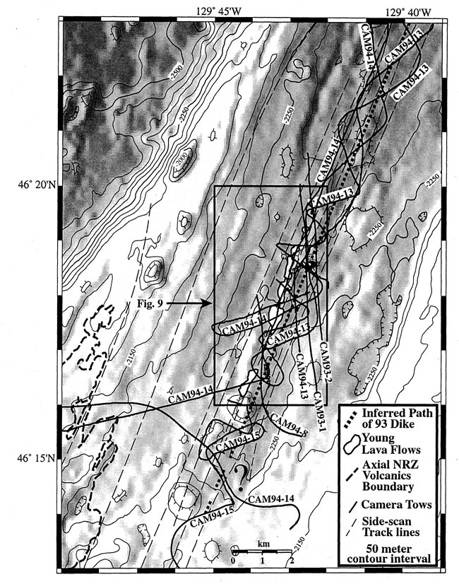
Figure 5. Bathymetric map of northernmost portion of CoAxial segment, including
the Flow site. Bathymetry is side-lit from west with 50-m contours superimposed.
Darker shades are deeper. Box shows area of Figure
6. Location on regional bathymetry shown in Figure
1.
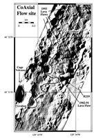
Figure 6. AMS-60 side-scan mosaic (two swaths) of 1993 and 1982–1991
lava flows at the Flow site, CoAxial segment. White lines are boundaries of
young lavas determined by SeaBeam differencing anomalies and ROPOS and Alvin
dives [Chadwick et al., 1995]. Dotted lines denote depth cross-section locations
shown in Figure 7. Location shown in Figure
5.

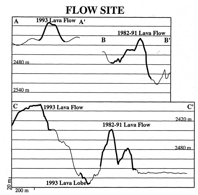
Figure 7. Depth cross-sections along submersible traverses of young lava
flows at the Flow site, CoAxial segment. Young lavas are highlighted by thicker
lines. Locations shown in Figure 6.
Differencing of SeaBeam bathymetric grids from surveys made in 1982, 1991,
and 1993 shows a well-defined positive depth anomaly coinciding with the glassy,
unsedimented lava observed (Figure 6 and Plates
2a and 2b) [Chadwick
et al., 1995]. One of the thicker (~30 m) portions of the lava
flow centered at 46°32.4N (Figure
6) coincides with an area of intense hydrothermal activity observed during
ROPOS and Alvin dives in 1993 (Figure
6 and Plate 2c). Seafloor observations
made during ROPOS dives (e.g., R219, Figure
6) in August 1993 (probably less than 2 weeks after the eruption) showed
that the crestal region of the lava flow was emitting an extensive flow of warm
water up to 50°C from an area of drained-out flattened pillow lavas.
Fe-Si precipitates coated large areas of the crestal area where active venting
was taking place (Plate 2c) [Embley
et al., 1995; Juniper
et al., 1995].

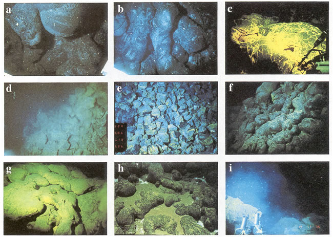
Plate 2. A series of 35-mm photographs from ROPOS (R) and Alvin (A) of lava
flows and vents on CoAxial segment. Origin and year of photograph are given
by, e.g., R93: (a) Lobes of pillow lavas on east flank of 1993 flow. Darker
bands on pillow (~0.75 m diameter) in upper middle right are very delicate veneer
of glass which sloughed off on contact. White particles are fallout in water
column (Figure 6, ROPOS Dive 219, R93).
(b) Sediment-free glassy tubes and pillows on east flank of 1993 eruption mound
(R93). Pillow tube in center is ~0.5 m across (Figure 6,
ROPOS Dive 219, R93). (c) Crest of 1993 lava flow showing extensive coating
of Fe-Si deposit probably precipitated by Fe-oxidizing bacteria. Temperature
probe (~1 m long) at lower right measured exit vent fluid temperatures as high
as 51°C in the vicinity of this site (R93). (d) Extensive venting along
fissure south of 1993 eruption (R93). (e) Brecciated zone along path of venting
south of 1993 eruption site (Figure 7, Alvin
Dive 2990, A95). Pieces are ~0.25 m across. (f) Flank of 1982–91 lava site
lying 500 m east of the 1993 flow (A93). (g) Crest of the 1982–1991 lava
flow; note duller color than Plate 2c (A93).
(h) "Floc" drifts amidst older pillow lavas (note thick sediment pockets)
along center of axial valley at about 46°19.4N (R93). (i) Turbid vent fluid
rising out of fissure near Huge Diffuse Vent (HDV) at Floc site (Figure
9) (A93). Fissure is ~1 m wide.
High-resolution near-bottom bathymetric surveys using an AMS-60 deep-towed
side-scan sonar and a Mesotech scanning sonar mounted on Alvin mapped
well-defined narrow (~20 m wide) grabens at both the southern and northern
ends of the 1993 lava flow (Figure 6). Chadwick
and Embley [1998] propose that these structures formed above
the 1993 dike that fed the eruption. In this paper we use the terms "fissure"
and "graben" as by Chadwick
and Embley [1998]. A fissure is a fracture whose walls have moved
apart by pure extension. A graben is a linear topographic depression created
by subsidence along inward facing normal faults. Small grabens are distinguished
from fissures in that they have a well-defined downdropped center block.
Surveys and seafloor observations using the ROPOS and Alvin mapped
at least three small patches of lava north of the main lava flow (the northernmost
is at 46°32.5N) that erupted out of
narrow grabens. Low-level diffuse venting was observed within the northern graben
in August 1993, but none was observed in July 1994. An Alvin dive within
the graben at the southern end of the main lava flow (Figure
6) in October 1993 found extensive diffuse hydrothermal venting and bacterial
mats along its eastern wall, but venting had ceased by September 1995. Extensive
venting was also found southwest of the 1993 flow on the plateau south of Cage
Volcano in August 1993 at sites extending for 5 km SSW (~N202°E)
of the main lava flow (Figure 5 and Plate
2d). All six ROPOS transects, including the southernmost one at 46°28.4N,
crossed a narrow zone of venting associated with small grabens and or fissures
that cut through pre-1993 lavas (Figure 5). No
recently erupted lava was observed on any transect south of the main lava flow.
Camera tows in 1994 and Alvin dives in 1995 (Figure
5) did not detect any active hydrothermal venting south of the lava flow
where ROPOS observed it in 1993, but Alvin transects at two sites
revealed "fresh" appearing fissures and small grabens characterized by bright
white and yellow staining on the broken rock faces (Figure
5). At 46°29N, Alvin (dives
2990 and 2992) encountered a very unusual fractured zone characterized by brecciated,
pervasively stained basalt lying within a shallow graben up to 10 m wide (Plate
2e). Careful observation from Alvin's viewports confirmed that this
rubble was generated in situ, not tectonic talus generated from a nearby scarp.
The zone appeared to be continuous for at least 500 m along strike and located
along the line of (apparent) continuous venting observed by ROPOS in
1993.
In summary, the 1993 CoAxial eruption site consists of a 3.8-km-long,
(up to) 500-m-wide lava flow, a zone of grabens and fissures extending at least
1 km northward which fed several small eruptions, and a zone extending at least
~4.5 km to the south characterized by grabens, fractured seafloor, and
extensive diffuse venting (in 1993), but no fresh lavas. This entire active
zone is at least 8.4 km in length. A plot of the T wave epicenters (Figure
1) shows that the events in the second half of the swarm(s) (after JD184)
form a "bulls-eye" pattern at the eruption site that has the same diameter (~
8 km) as the length of known along-axis venting and eruption (southern limit
shown on Figure 5). The character and geometry
of these structures as well as the short duration of hydrothermal venting along
them are all consistent with the interpretation that they formed directly above
the 1993 dike and thus reveal the path that the dike took along this section
of the CoAxial segment. There is no evidence for any other 1993 eruption sites,
but repeat SeaBeam surveys and camera tows have identified two pre-1993 eruption
sites along the CoAxial segment, which are described in sections 6 and 8.
6. The 1982–1991 Lava Flow at the Flow Site
The first dive by ROPOS at the Flow site in August 1993 crossed over
a largely sediment-free, glassy lava flow lying about 700 m east of the 1993
flow (Figures 5, 6,
and 7). Subsequent comparison of SeaBeam surveys
clearly showed that this lava was erupted between 1982 and 1991 [Chadwick
et al., 1995]. This older flow appears to be morphologically
similar to the 1993 flow, consisting of mostly pillow lavas (Plate 2f)
but with a distinct zone of flattened and partially drained-out pillow flows
along the crest of the mound. The crest of the 1982–1991 lava flow
has a veneer of dull yellow Fe-Si sediment (Plate
2g), which is likely the Fe-Si precipitates observed forming during the
cooling phase of the 1993 lava flow (Plate 2c).
Similar precipitates were also found on the crest of the lava mounds
on the northern Cleft segment that erupted in the mid-1980s [Chadwick
and Embley, 1994], so the presence of these deposits is now a
well-documented indicator of the cooling phase of recent pillow lavas and their
feeder dikes. The northern extent of this flow is currently unknown due to lack
of near-bottom photographic coverage. The separation between this eruptive mound
and the 1993 mound is ~800 m (centerline to centerline).
7. Floc Site
The July/August 1993 CTDT (conductivity, temperature, depth, light transmission)
profiles showed high light attenuation values in the plumes located around 46°18N
and centered above the CoAxial neovolcanic zone in the middle of the axial valley
[Baker
et al., 1995; Embley
et al., 1995]. This area became known as the "Floc site" (Figures
1, 8, and 9).
It should be noted that at the latitude of the Floc site, almost all of the
epicenters in the 1993 T wave swarm are west of the CoAxial neovolcanic
zone. The Floc site is where a mismatch between the T wave locations
and seafloor geology becomes clear. A ROPOS dive at the Floc site in
1993 observed large white particles up to 200 m above the bottom and
"snowdrifts" of these flocculent particles on the seafloor (Plate
2h). After localizing the source area with the Scripps Deep-Tow system in
August [Spiess
and Hildebrand, 1993], Alvin dives in October 1993 documented
extensive diffuse venting along a fissure and graben system, including
some places where vent fluid was so laden with large white particles that the
sites became known as "snow blower" vents (Plate
2i) [Haymon
et al., 1993]. Taylor
and Wirsen [1997] propose that production of these particles
is controlled by direct excretion of filamentous sulfur from sulfur oxidizing
bacteria. A high production of sulfur-rich particles was produced at the 9°45–52N
East Pacific Rise site [Haymon
et al., 1993], and there is photographic evidence (Embley, unpublished
data, 1987) for a large particle accumulation on the seafloor following the
mid-1980s eruption at the north Cleft site [Embley
and Chadwick, 1994]. Hyperthermophilic Archaea (with
optimal growth ranges of 90°C) were cultured from vent fluids sampled
from the Floc site in October 1993 (but not subsequently), strongly implying
the presence of a viable, substantive subsurface microbial biomass at this site
in the months following the 1993 dike intrusion [Delaney
et al., 1998; Holden
et al., 1998].
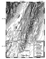
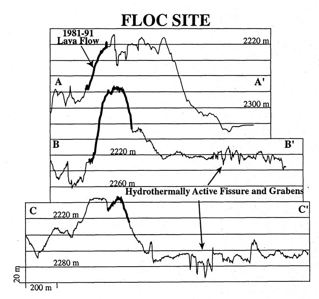
Figure 8. Bathymetric map of central CoAxial segment, including the Floc
site. See Figure 5 caption for details.
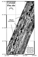
Figure 9. AMS-60 side-scan mosaic of fissure swarm (solid white lines) and
1981–1991 lava flows (white outline) at the Floc site. Boundaries of young
lavas, extent of venting along fissure, and vent sites (e.g., Mkr 18) determined
from camera tows (Figure 8) and Alvin dives.
Location of map shown by box in Figure 8. Dotted
lines are depth cross-sections shown in Figure 10.
Observations from the Alvin dives and camera tows presented here and
from the plume surveys [Baker
et al., 1998] show that diffuse venting was occurring over >5
km along strike from 46°16 to 46°19N
(between Mkr 18 and Mkr 5 on Figure 9). Alvin
dives in the fall of 1993 observed only bacterial mats at these vent sites (Plates
2i and 3a), but subsequent dives in 1994
and 1995 to the same marked sites documented a rapidly evolving macrofaunal
community [Tunnicliffe
et al., 1997] (Plates 3b and 3c).
By 1995, visible venting had declined to just a few isolated sites, notably
at the Huge Diffuse Vent (HDV) and marker 18 sites (Figure
9) and by 1996, observations (using ROPOS) of extensive predation
by crabs marked the rapid decline in the macrofaunal communities at the HDV
site (V. Tunnicliffe, personal communication, 1996) (Plate
3d). Time series observations of hydrothermal plumes for the same period
also show a rapid decline. By 1996, heat and particle content above the Floc
and Flow sites had returned nearly to background levels [Baker
et al., 1998]. These observations are consistent with the interpretation
that the 1993 dike intruded close to the surface beneath the Floc site but by
1996 had cooled to the point that it was no longer producing enough H S
flux to support chemosynthesis at the seafloor/rock interface. The rapid contraction
of hydrothermal/biological sites above a dike intrusion was also observed at
the Cleft segment following its mid-1980s eruption [Embley
and Chadwick, 1994; Embley
et al., 1994].
S
flux to support chemosynthesis at the seafloor/rock interface. The rapid contraction
of hydrothermal/biological sites above a dike intrusion was also observed at
the Cleft segment following its mid-1980s eruption [Embley
and Chadwick, 1994; Embley
et al., 1994].
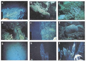
Plate 3. A series of 35-mm photographs from ROPOS, Alvin , and towed camera
of Floc and Source sites: (a) Bacterial mats coating wall of fissure at Floc
site (A-1993). (b) Nemerteans (each ~3 cm in length) on bacterial mats on wall
of fissure at southern Floc site near marker 18 (Figure
9) (A95). (c) Tubeworms (~0.3 m long) at HDV vent, Floc site (A95). (d)
Crabs feeding on remnants of tubeworm community at the HDV vent at the Floc
site (R96). (e) Young lavas (upper) coating wall of older lavas in fissure at
Floc site near marker 18 (A95). (f) The 1981–1991 pillow lavas at the Floc
site. Note small but distinct sediment pockets in these lavas (A95). Pillow
is ~1 m across. (g) Photo from USGS towed camera of sediment-covered lavas between
the AVNRZ and the CoAxial neovolcanic zone. Photo is ~5 m across. (h) Top (~2
m) of 7-m chimney ("Mongo") at Source site. (i) Small chimneys (~0.5–1.0
m high) at Source vent lining up on structure oblique to primary chimneys.
Structural control of the venting at the Floc site is revealed by side-scan
imagery, which shows a braided and anastomosing fracture system 100–200
m wide cutting through low-relief seafloor from about 46°16N
to 46°19.5N (Figures
9 and 10). This zone probably consists largely
of preexisting structures that were reactivated during the 1993 intrusion (in
contrast to the Flow site where the structures hosting active venting appeared
to be new [Chadwick
and Embley, 1998]). The southern part of the zone was apparently
an eruptive vent in the recent past; submersible observations showed extensive
drainback of young sheet flows between 46°17.5N
and 46°18.5N. An old sequence of
pillow lavas was observed to be partly "coated" with a veneer of younger sheet
flows characterized by "bathtub rings" (Plate 3e).
Such drainback features are characteristic of eruptive fissures observed (mostly)
on intermediate to fast portions of the MOR. An interesting aspect of the venting
at the Floc site was that while it was located within a zone that consists of
many individual structures, the venting at any particular location was always
localized along a single fissure or graben, usually the westernmost structure
in the swarm. Hydrothermal fluids vented from the floor, walls, and rims of
the structures.
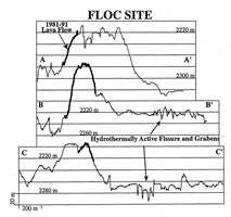
Figure 10. Depth cross sections of Floc site. Locations shown in Figure
9.
Sohn
et al. [1998] located nine microearthquakes at the center of
the CoAxial axial valley between 46°13N
and 46°17N during a 1-month deployment
of an ocean bottom seismometer array in 1994, 1 year after the eruption. Sohn
et al. [1998] attribute this activity to post diking tectonic
adjustments, which is consistent with the geologic evidence presented here.
8. The 1981-1991 Lava Flows at the "Floc Site"
The 1994 deep-towed camera survey delineated a series of young, glassy lava
flows extending for 7 km along a ridge ~500 m west of the actively venting fissure
swarm at the Floc site (Figures 8, 9,
and 10). The lava erupted along a preexisting
ridge; in some locations it flowed down the east side of the ridge and at other
places down the west side (Figure 10). Application
of the SeaBeam differencing technique revealed a small but distinct depth difference
anomaly (up to 25 m) between the 1981 and 1991 surveys which coincides
exactly with the young lava mound delineated by the towed camera at 46°17.5N,
129°43.3W. Note that this SeaBeam anomaly
is different than the "southern 1981–1991 SeaBeam anomaly" tentatively
identified at 46°26.2N by Chadwick
et al. [1995], which our 1994 camera tows revealed to be false.
The Floc site anomaly discussed here was also assumed to be an artifact [Chadwick
et al., 1995] because it was relatively small in area and did
not have any photographic groundtruthing at the time. The absence of additional
SeaBeam difference anomalies coinciding with the other areas of glassy
lavas mapped by the towed camera suggests that most of the 1981–1991 lava
flows at the Floc site are thinner than ~5–15 m, which is the vertical
resolution of this technique [Fox
et al., 1992]. The SeaBeam differencing results do not allow
age discrimination between the 1982–1991 lava flow at the Flow site and
this one at the Floc site. However, close examination of Alvin
hand-held photographs of the two sites suggests that the Floc site pillow mounds
are slightly older because they have small sediment pockets and do not
have as vitreous a luster as the northern lavas (compare Plates
2f and 3f). The towed camera imagery and
video traverses made with the submersible Alvin show that neither of
the 1981–1991 flows were fractured, nor were they colonized with sessile
organisms.
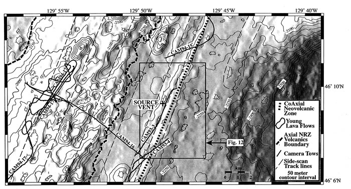
9. Southern CoAxial Segment and the "Source Site"
The southern third of the CoAxial axial valley (south of about 46°14N)
is characterized by a distinct median volcanic ridge (Plate
1 and Figure 11). The ridge summit is covered
with young pillow lavas with small pockets of sediment and small areas of sheet
flows at its southern end (~46°07N)
where it broadens. Seafloor between the median ridge and the AVNRZ (dashed line
on Figure 11) consists of heavily sedimented
sheet flows (Plate 3g). A young pillow mound
on the axis of the AVNRZ centered at 46°10N,
129°55W (Figure
11) mapped by the towed camera probably represents a single eruption from
a recent diking episode originating at or near the summit of Axial Volcano.
No SeaBeam anomaly was found at this site, so it apparently precedes all of
the historic CoAxial eruptions.
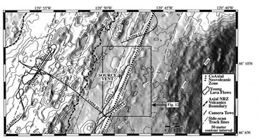
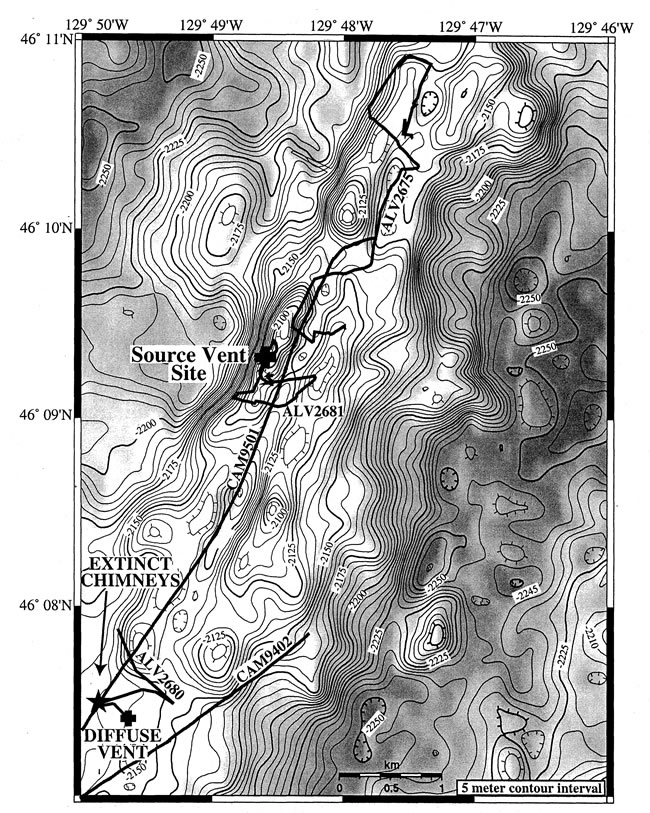
Figure 11. Bathymetric map of southern CoAxial segment including the Source
site. See Figure 5 caption for details. Location
of Figure 12 is shown by box.
CTDT tows along this part of the CoAxial segment in October 1993 encountered
a hydrothermal plume centered around 46°09N
(Figure 11) that was clearly separate from the
plumes originating at the known Floc and Flow sites to the north [Baker
et al., 1998] . The high-temperature vent site subsequently discovered
on Alvin dive 2681 in October 1993 became known as the "Source site"
because it was postulated that this site may have represented the magma source
region that generated the 1993 dike injection [Butterfield
et al., 1997].
The Source vent field is located on the west side of the neovolcanic ridge
of the CoAxial segment (Figure 12) along a fissure/fault
system. This ridge is the shallowest part of the CoAxial neovolcanic zone, rising
to ~2100 m in the vicinity of the vent site and thus is the most likely position
of a long-term hydrothermal system on this segment [Ballard
and Francheteau, 1982; Crane,
1985]. The vent site consists of four major vents aligned at about
N022°E along a west facing scarp (Plate 3h).
The chimneys are spaced ~10–20 m apart and the entire vent field is <100
m in length. Less vigorous venting also occurs on small chimneys west of and
slightly deeper than the large ones. The small chimneys are oriented
along trends about N040°W and intersect the primary vents (Plate
3i). This pattern suggests that the locations of the vents may be controlled
by intersection of two structural trends such as has been documented at the
Endeavour Main Field [Delaney
et al., 1992]. The metal-poor vents emit a clear or grayish "smoke"
with a maximum temperature of 294°C. Butterfield
et al. [1997] concluded that these fluids have a relatively long
crustal residence time compared to other hydrothermal systems on the JdFR, but
the mechanism for this is unclear.
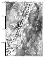
Figure 12. Bathymetry of "Source" site with camera, dive tracks,
and locations of sites discussed in text. Side-lit from west. Contour interval
is 5 m.
The only other active hydrothermal activity found nearby was an an area of
diffuse venting a few tens of meters on a side about 3.5 km to the south (Figure
12). Small mounds of iron oxides had a fluid temperature only ~4°C
above ambient. A line of extinct sulfide chimneys was found several hundred
meters northwest of the diffuse vent. These Zn-rich chimneys lie along a small
fault aligned along N020°E and extend for at least 100 m along the same
trend as the active high-temperature vent field to the north (Figure
12). The presence of these older chimneys indicates that this site has had
a long-term history of high-temperature venting. To date, no other high-temperature
activity (either past or present) has been found along the length of the
CoAxial segment.
Several observations lead one to the conclusion that the Source site predated
and was probably not affected by the 1993 seismic swarm. First, the initial
seismic activity was to the north and northwest of the site (Figure
1); there were no SOSUS-detected events located along this ridge. Second,
the submersible dives and camera tows across and along the ridge yielded no
geologic or biologic evidence of very recent tectonic events or young venting
such as observed at the Floc site. Last, analyses of a time series of vent fluid
samples from this site taken in 1993, 1994, and 1995 [Butterfield
et al., 1997] do not show the rapid changes in temperature and
chlorinity that characterize other recent eruption sites [Butterfield
et al., 1997; Butterfield
and Massoth, 1994; Von
Damm et al., 1995]. Considering these data, it now seems unlikely
that the Source site was significantly perturbed by the 1993 event.
10. Discussion
10.1. Relationship of T Wave Seismicity to Seafloor Structure and Geologic
Observations
Where did the 1993 dike originate and how does the spatial pattern of the 1993
T wave swarm relate to the physical manifestations of the 1993 dike intrusion
on the seafloor? A puzzling problem has been the discrepancy between the trend
of the 1993 T wave swarm and the trend of the neovolcanic zone at CoAxial
as defined by geologic mapping. We think that the 1993 dike intruded from a
magma source beneath the southern CoAxial segment and propagated northward along
the CoAxial neovolcanic zone and that Axial Volcano was not involved in the
1993 event, for the following reasons:
- Hydrothermal plumes related to the 1993 dike intrusion were located over
the neovolcanic zone of CoAxial segment, not along the trend of T wave
epicenters [Baker
et al., 1998].
- Time series measurements of hydrothermal plumes at both the Flow and Floc
sites show a power law decline of temperature and rise height, consistent
with the expected thermal decline during the cooling of a dike [Baker
et al., 1998; Cherkaoui
et al., 1997].
- Venting sites on the seafloor were located directly under the hydrothermal
and exclusively along the neovolcanic zone of CoAxial. The evolution of the
vent sites on the seafloor at the Flow and Floc sites, including a rapid bacterial
bloom followed by rapid cooling of the system, is consistent with a geothermal
response to an intruded dike. Geothermal perturbations associated with dike
intrusions in volcanic rift zones on land generally appear directly over the
axis of the dike [Björnsson
et al., 1979].
- SeaBeam bathymetry of the central JdFR is consistent with Axial Volcano
and its rift zones effectively behaving as one of many independent spreading
segments along the ridge, with overlapping (but not intersecting) relationships
with the adjacent ridge segments (Vance and CoAxial).
- Side-scan imagery and bottom photography delineate the neovolcanic zones
of AVNRZ and CoAxial segment and show that they are separate from one another.
The northern limit of the AVNRZ only extends to 46°15–18N,
where it merges with the western fault block ridge, an older tectonized feature
hypothesized to have formed along CoAxial. There is no evidence from geologic
mapping that dikes have propagated in the past from the AVNRZ into and along
the neovolcanic zone of CoAxial. Although dikes intrude at variable directions
over a period of time on a given rift zone [Gudmundsson,
1990], it is difficult to envision how a dike could propagate across
structure from one volcanic rift zone to another and then along structure
on the second rift zone.
- An ocean bottom seismometer deployment made around the Floc site detected
small earthquakes tightly clustered at the Floc site along the trend of the
neovolcanic zone [Sohn
et al., 1998].
- Geochemistry of lavas from Axial Volcano and its rift zones is distinct
from lavas collected from CoAxial segment, particularly with relation to Sr
isotopic signatures. Geochemical signatures of the 1993 lava flow and the
two 1981–1991 flows indicate that they all came from CoAxial magma sources,
not from Axial Volcano.
- Detailed geologic mapping of the low-temperature hydrothermal vent sites
on the seafloor associated with the 1993 intrusion shows that the vents are
localized along fissures and small grabens which are interpreted to have formed
or were reactivated directly over the 1993 dike while it was intruding. These
structures which trace the path of the dike are located within the CoAxial
neovolcanic zone.
Therefore all of the geologic and geochemical evidence leads to the conclusion
that the 1993 dike originated within the CoAxial segment and intruded northward
along its neovolcanic zone and did not follow the path suggested by the T
wave epicenters from AVNRZ to CoAxial. What could explain the oblique trend
of the T wave swarm, particularly since the T wave epicenters
cluster perfectly above the 1993 eruption site at the northern end of the swarm?
There are two hypotheses that could explain this discrepancy. One hypothesis,
suggested by Fox
et al. [1995], is that the first half of the T wave swarm
consisted of deeper earthquakes [Schreiner
et al., 1995] and the relatively shallow seafloor to the west
of the central CoAxial segment may have radiated more of the acoustic energy
and so added a systematic location error to the epicenters in the southern part
of the swarm. A second hypothesis is that the early T wave events might
have been associated with faulting along the boundary of the western fault block
ridge rather than directly associated with the dike itself, located on-axis.
Intruding dikes have triggered normal faulting in volcanic rift zones on land
[Rubin,
1992; Sigurdsson,
1980], and several normal fault earthquakes located on the bounding
faults of the summit caldera of Axial Volcano were triggered during the early
stages of the 1998 dike injection there [Dziak
and Fox, 1998, 1999].
10.2. Implications for Stress Release During Accretion Events on the Mid-Ocean
Ridge
Three separate eruptions have occurred on the CoAxial segment within the 12-year
period from 1981 until 1993 (Plate 1). The
two younger eruptions occurred near the northern end of the segment,
and the oldest event occurred at the midpoint of the segment at 46°15–21N.
How much strain has been released during this time period and what are the
implications for the space-time pattern of strain and volcanism for the
rest of the ridge system? It seems reasonable to assume that the two 1981–1991
eruptions represent diking events similar to the 1993 event because since (1)
all the lava flows are similar in volume and are elongated along the axis of
the neovolcanic zone, and (2) all of the other known historical eruptions documented
to date along the northeast Pacific spreading centers [Chadwick
et al., 1998; Dziak
and Fox, 1998; Dziak
et al., 1995; Embley
and Chadwick, 1994] have been associated with dikes that have
intruded over tens of kilometers along axis. The T wave epicenters suggest
that the 1993 dike was injected from a latitude between the Floc and Source
sites (~46°12N), so presumably a magma
reservoir exists beneath the axis of CoAxial around this location. If we assume
that all three recent eruptions were fed by dikes that intruded northward from
this area, this may have interesting implications for the pattern of stress
accumulation and release from this section of the ridge. At a spreading
rate of 5.5 cm/yr, each meter thickness of intruded dike relieves about 18 years
of accumulated stress. Although we cannot directly estimate the thickness
of any of the dikes intruded during the CoAxial events, estimates of dike widths
from sections of oceanic crust exposed in ophiolite sections are typically 0.5–1.5
m [Gillis,
1995]. The three documented eruptions occurring over a 12-year
period represent only a minimum number of diking events because additional
events may have taken place without producing eruptions in the 1981–1991
period prior to SOSUS monitoring and after the initial SeaBeam survey. Also,
the lack of teleseismic events (M 4)
along this portion of the ridge (R. Dziak, personal commununication, 1999) in
the 1966–93 time period suggests that faulting was not a significant factor
in stress release for this period. Nevertheless, the record of recent eruptions
at the CoAxial segment represents the first direct evidence of the style of
stress release over the timescale of a about a decade along a portion
of the MOR. The CoAxial diking events of 1981–1993 must have relieved a
significant amount of stress along the segment. No diking events have been detected
by SOSUS in the 1993–1999 period.
Although the period of observation is very short, this pattern could be analogous
to the behavior of Icelandic central volcanos. The long-term record of
volcanism in Iceland shows that the central volcanos release accumulated stress
in a series of major rifting/volcanic events about every 100–150 years
[Björnsson
et al., 1979]. During the latest of these episodes, the Krafla
Volcano produced 20 diking/rifting events between 1975 and 1984, only about
half of which erupted lava at the surface [Björnsson,
1985]. Whether the CoAxial "rifting episode" has ended remains
to be seen, although at the time of this publication, the segment has been seismically
quiet for 6 years. Geodetic monitoring of the Krafla episode suggests that as
each diking event relieves some of the regional stress, it becomes more difficult
to inject additional dikes into an increasingly compressive stress field [Ewert
et al., 1991].
10.3. Implications for Magma Delivery Systems at Intermediate Spreading Rates
How magma is delivered along segments of the MOR is poorly known because of
the lack of direct measurements of 3-D seismicity patterns and deformation during
diking events. Models of magma delivery systems have been mostly inferred from
surface morphology, lava geochemistry, and geophysical measurements [Batiza,
1996]. Even in Iceland, where a rifting episode was monitored in
1975–1984 at the Krafla Volcano and where there has been extensive geologic
mapping, there remains some controversy as to how magma is delivered to the
upper crust. The seismicity patterns during the Krafla rifting events showed
that at least some of the dikes were propagated laterally from beneath Krafla
caldera [Einarsson
and Brandsdottir, 1980] and this led Sigurdsson
[1987] to propose that lateral propagation of dikes is an important
process on Icelandic central volcanos. On the other hand, Gudmundsson
[1995] concludes that many of the long dikes generated during episodes
on Icelandic central volcanos are propagated primarily vertically from deeper
magma sources. Another source of information about magma delivery systems comes
from ophiolites. Interestingly, a study of flow directions in the dikes of the
Troodos ophiolite [Varga
et al., 1998] showed a significant lateral component of magma
transport during diking.
Embley
et al. [1994] proposed that the dike(s) that produced the 1980s
eruption(s) at the north Cleft segment had a significant lateral component.
This was based primarily on the observation that hydrothermal cooling proceeded
more rapidly at the end of the dike even though that is where the largest eruption
occurred. Their preferred interpretation of this observation was that the distal
end of the dike is "rootless"; that is, it did not erupt vertically from a local
magma source but was fed laterally from a more robust magma source. The longer-lasting
high-temperature venting associated with a sheet flow eruption to the south
was assumed to be over the location of the primary magma source.
What was the mode of dike injection during the 1993 event? The northward propagation
of the T waves during the 1993 CoAxial event is certainly consistent
with a lateral dike injection [Dziak
et al., 1995]. Also, Butterfield
et al. [1997] concluded that the chemistry of the 1993 pillow
mound site vent fluids could be explained by the cooling of the dike and lava
flow alone (i.e., "rootless portion"), whereas the chemistry of the fluids at
the Floc site constrained them to a larger and hotter source. Although there
were no observations of active venting on the older pillow lava eruptive mounds
at the CoAxial site, the presence of the yellowish sediments on the 1982–1991
mound is consistent with a low-temperature reaction zone of a rapidly cooling
dike and lava flow. Smith
[1999] explained a decrease in MgO content in the lavas at the Floc
site 1981–1991 eruption mounds as crystal fractionation within a northward
propagating dike. Finally, two of the CoAxial eruptions and the north Cleft
eruption [Chadwick
and Embley, 1994] were characterized by 80–100% of the eruption
by volume being emplaced at the deep end of the segments. This pattern is also
consistent with a lateral dike injection in that it is [Fialko
and Rubin, 1998] hydraulically easier to erupt lava as the seafloor
deepens.
Thus the spatial and temporal patterns of eruption and hydrothermal cooling
and the lava geochemistry of the 1993 and older events are consistent with a
dike that had a significant lateral component of injection. Admittedly, this
conjecture is largely circumstantial, unfortunately; there are very few data
(e.g., seismic reflection) on the along-axis melt supply of the Juan de Fuca
Ridge. However, some new and more direct evidence for lateral dike injection
on a segment of the Juan de Fuca Ridge was the 3-m drop in the caldera of Axial
Volcano (Figure 1) measured by a seafloor pressure
gauge coupled with eruption of lava on the rift zone during the seismicity episode
in 1998 [Fox,
1999; Embley
et al., 1999]. Clearly, monitoring of diking events (at a range
of spreading rates) with arrays of seismometers and instruments to measure vertical
and horizontal strain is needed to provide more definitive data on the geometry
of MOR crustal level magma plumbing systems.
11. Conclusions
- The 1993 CoAxial eruption on the Juan de Fuca Ridge is the third well-documented
eruption to occur on this segment since 1981. These closely spaced events
probably released decades of accumulated stress along this segment.
- These three eruptions were generated by dike injections from within
the CoAxial segment. The alternate hypothesis that the 1993 dike propagated
from Axial Volcano appears unlikely, both because the Sr isotopes of the most
recent extrusives from Axial Volcano and the CoAxial segment are different
and because the surface manifestations of the 1993 dike at the Floc and Flow
sites (short-term hydrothermal venting along dike-related structures) clearly
line up along the axis of the CoAxial segment.
- The epicenters from the early, southern part of the 1993 T wave swarm
must either be systematically biased to the west or were related to faulting
along the western fault block ridge induced by the dike intrusion on-axis.
- On the other hand, the 1993 lava flow and the along-axis extent of intrusion-related
venting at the Flow site coincide very well with the diameter of the cluster
of T wave epicenters that occurred during the later, northern part
of the seismic swarm.
- The venting at the Floc site occurred along a preexisting, 5 to 6-km-long
fissure system between about 46°16N
and 46°19.5N. This fissure system
did not produce eruptions during the 1993 event, but sheet flows had been
erupted from the system in at least two locations in the recent
past.
- The fact that hydrothermal activity lasted 1–2 years longer at the
Floc site than at the Flow site means that the Floc site had a larger source
of heat to mine, probably due to the 1993 dike being wider and/or extending
deeper beneath the site.
- The Source site was apparently a preexisting high-temperature hydrothermal
system and was unaffected by the 1993 dike intrusion.
- The source area of the dike(s) that fed the 1993 eruption on the CoAxial
segment (and possibly the two 1981–91 eruptions) appears to be located
somewhere between the Source and Floc sites (~46°12N),
the latitude at which the T wave swarm started.
- The three diking events that occurred along the CoAxial segment between
1981 and 1993 must have relieved a significant amount of strain along at least
a portion of the segment and the lack of any more events since 1991 makes
a comparison to the behavior of Icelandic central volcanos tempting.
- The available observations of the patterns of extrusion and hydrothermal
cooling and of the geochemistry of the lavas and vent fluids venting for these
1981–1993 CoAxial eruptions are consistent with that predicted from a
dike having a significant lateral component of injection.
Acknowledgments. Without the goodwill of the U.S. Navy in opening up
their SOSUS system to the scientific community, the June–July 1993 eruption
would almost certainly have gone undetected and the detailed studies reported
in this paper would never have been carried out. The NOAA VENTS Program
provided support for onshore data analysis and a good portion of the seagoing
effort. We particularly thank the ROPOS and Alvin groups
and the crew and scientific parties of the research vessels Discoverer
and Atlantis II for their excellent support. Williamson and Co. of Seattle,
Washington, provided excellent support for the 1996 AMS-60 side-scan survey,
and we thank Stuart Sides and Miguel Valasco of the U.S. Geological Survey
for their excellent at-sea processing of the data. H.P. Johnson generously included
the senior author on the 1995 Alvin expedition and allowed us use of
some of the dive data. R. Koski and Hank Chezar generously provided data collected
by the U.S. Geological Survey's deep-towed camera system in 1993–1994.
The NOAA Undersea Research Program and the National Science Foundation provided
generous support for the Alvin dives in 1993–1995. We especially
thank D. Kelley, J. Getsiv, T. Gregg, S. Hanneman, R. Greene, A. Bobbitt, and
D. Wright for their many long hours on watch during the Discoverer and
Atlantis II expeditions. S. Merle and Paul D. Johnson provided excellent
technical and graphics support. We are also grateful to Ralph Currie, H. P.
Johnson, and Mark Holmes for providing tapes of the SeaMARC II data, and to
V. Tunnicliffe for Plate 3d. PMEL contribution
2063.
References
Appelgate, T.B., Morphology of the south flank of Axial Volcano, Juan de Fuca
Ridge: Results from a Sea MARC I side scan sonar survey, J. Geophys. Res.,
95, 12,765–12,783, 1990.
Baker, E.T., G.J. Massoth, R.A. Feely, R.W. Embley, R.E. Thomson, and B.J.
Burd, Hydrothermal vent plumes from the CoAxial seafloor eruption site, Juan
de Fuca Ridge, Mar. Geophys. Res., 22, 147–150, 1995.
Baker, E.T., G.L. Massoth, R.A. Feely, G.A. Cannon, and R.E. Thomson, The rise
and fall of the CoAxial hydrothermal site, 1993–1996, J. Geophys. Res.,
103, 9791–9806, 1998.
Ballard, R.D., and J. Francheteau, The relationship between active sulfide
deposition and the axial processes of the mid-ocean ridge, Mar. Technol.
Soc. J., 16, 8–22, 1982.
Ballard, R.D., R.T. Holcomb, and T.H. van Andel, The Galapagos Rift at 86°W,
3, Sheet flows, collapse pits, and lava lakes of the rift valley, J. Geophys.
Res., 84, 5407–5422, 1979.
Batiza, R., Magmatic segmentation of mid-ocean ridges: A review, in Tectonic,
Magmatic, Hydrothermal and Biological Segmentation of Mid-ocean Ridges,
edited by C.J. MacLeod, P.A. Tyler, and C.L. Walker, pp. 118–130, Geol.
Soc. London, 1996.
Björnsson, A., Dynamics of crustal rifting in NE Iceland, J. Geophys.
Res., 90, 10,151–10,162, 1985.
Björnsson, A., G. Johnsen, S. Sigurdsson, G. Thorbergsson, and E. Tryggvason,
Rifting of the plate boundary in north Iceland 1975–1978, J. Geophys.
Res., 84, 3029–3038, 1979.
Butterfield, D.A., and G.J. Massoth, Geochemistry of north Cleft segment vent
fluids: Temporal changes in chlorinity and their possible relation to recent
volcanism, J. Geophys. Res., 99, 4951–4968, 1994.
Butterfield, D., I.R. Jonasson, G.J. Massoth, R.A. Feely, K.K. Roe, R.W. Embley,
J.F. Holden, R.E. McDuff, M.D. Lilley, and J.R. Delaney, Seafloor eruptions
and evolution of hydrothermal fluid chemistry, Philos. Trans. R. Soc. London,
Ser. A, 355, 369–386, 1997.
Chadwick, W.W., Jr., and R.W. Embley, Lava flows from a mid-1980s submarine
eruption on the Cleft segment, Juan de Fuca Ridge, J. Geophys. Res.,
99, 4761–4776, 1994.
Chadwick, W.W., Jr., and R.W. Embley, Graben formation associated with recent
dike intrusions and volcanic eruptions on the mid-ocean ridge, J. Geophys.
Res., 103, 9807–9825, 1998.
Chadwick, W.W., Jr., R.W. Embley, and C.G. Fox, Evidence for volcanic eruption
on the southern Juan de Fuca Ridge between 1981 and 1987, Nature, 350,
416–418, 1991.
Chadwick, W.W., Jr., R.W. Embley, and C.G. Fox, SeaBeam depth changes associated
with recent lava flows, CoAxial segment, Juan de Fuca Ridge: Evidence for multiple
eruptions between 1981–1993, Geophys. Res. Lett., 22, 167–170,
1995.
Chadwick, W.W., Jr., R.W. Embley, and T.M. Shank, The 1996 Gorda Ridge eruption:
Geologic mapping, side-scan sonar, and SeaBeam comparison results, Deep Sea
Res., 45, 2547–2570, 1998.
Cherkaoui, A.S.M., W.S.D. Wilcock, and E.T. Baker, Thermal fluxes associated
with the 1993 diking event on the CoAxial segment, Juan de Fuca Ridge, J.
Geophys. Res., 102, 24,887–24,902, 1997.
Crane, K., The distribution of geothermal fields along the mid-ocean ridge:
An overview, in Hydrothermal Vents of the Eastern Pacific: An Overview,
edited by M. Jones, Bull. Biol. Soc. Washington, 6, 3–18, 1985.
Crane, K., F. Aikman, R.W. Embley, S. Hammond, A. Malahoff, and J.E. Lupton,
The distribution of geothermal fields on the Juan de Fuca Ridge, J. Geophys.
Res., 90, 727–744, 1985.
Davis, E., and R. Currie, Geophysical observations of the northern Juan de
Fuca: Lessons in sea-floor spreading, Can. J. Earth Sci., 30(2),
278–300, 1993.
Delaney, J.R., H.P. Johnson, and J.L. Karsten, The Juan de Fuca ridge–hot
spot–propagating rift system: New tectonic, geochemical, and magnetic data,
J. Geophys. Res., 86, 11,747–11,750, 1981.
Delaney, J.R., V. Robigou, R.E. McDuff, and M.K. Tivey, Geology of a vigorous
hydrothermal system on the Endeavour segment, Juan de Fuca Ridge, J. Geophys.
Res., 97, 19,663–19,682, 1992.
Delaney, J.R., D.S. Kelley, M.D. Lilley, D.A. Butterfield, J.A. Baross, W.S.D.
Wilcock, R.W. Embley, and M. Summit, The quantum event of crustal accretion:
Impacts of diking at mid-ocean ridges, Science, 281, 222–230,
1998.
Desonie, D., and R. Duncan, The Cobb-Eikelberg seamount chain: Hotspot volcanism
with mid-ocean ridge basalt affinity, J. Geophys. Res., 95, 12,697–12,711,
1990.
Detrick, R.S., Introduction to the seafloor mapping section, J. Geophys.
Res., 91, 3331–3333, 1986.
Detrick, R.S., P. Buhl, E. Vera, J. Mutter, J. Orcutt, J. Madsen, and T. Brocher,
Multichannel seismic imaging of a crustal magma chamber along the East Pacific
Rise, Nature, 326, 35–41, 1987.
Dziak, R.P., and C.G. Fox, Hydroacoustic detection of submarine volcanic activity
at Axial Volcano, Juan de Fuca Ridge, January 1998, Eos. Trans. AGU, 79(45),
Fall Meet. Suppl., F921, 1998.
Dziak, R.P., and C.G. Fox, The January 1998 earthquake swarm at Axial Volcano,
Juan de Fuca Ridge: Hydroacoustic evidence for seafloor volcanic activity, Geophys.
Res. Letts., 26, 3425–3428, 1999.
Dziak, R.P., C.G. Fox, and A.E. Schreiner, The June–July seismo-acoustic
event at CoAxial Segment, Juan de Fuca Ridge, Geophys. Res. Lett., 22,
135–138, 1995.
Einarsson, P., and B. Brandsdottir, Seismological evidence for lateral magma
intrusion during the 1978 deflation of the Krafla Volcano in NE Iceland, J.
Geophys., 47, 160–165, 1980.
Embley, R.W., and W.W. Chadwick, Jr., Volcanic and hydrothermal processes on
the southern Juan de Fuca Ridge, J. Geophys. Res., 99, 4741–4760,
1994.
Embley, R.W., K.M. Murphy, and C.G. Fox, High resolution studies of the summit
of Axial Volcano, J. Geophys. Res., 95, 12,785–12,812, 1990 .
Embley, R.W., W.W. Chadwick, M.R. Perfit, and E.T. Baker, Geology of the northern
Cleft segment, Juan de Fuca Ridge: Recent lava flows, seafloor spreading, and
the formation of megaplumes, Geology, 19, 771–775, 1991.
Embley, R.W., W.W. Chadwick Jr., E.T. Baker, G. Massoth, D. Butterfield, R.
Koski, I.R. Jonasson, J.R. Delaney, R. McDuff, M. Lilley, and J. Holden, Comparison
of two recent eruptive sites on the Juan de Fuca Ridge: Geological setting and
time-series observations, Eos Trans AGU, 75(44), Fall Meet. Suppl.,
617, 1994.
Embley, R.W., W.W. Chadwick, I.R. Jonasson, D.A. Butterfield, and E.T. Baker,
Initial results of the rapid response to the 1993 CoAxial event: Relationships
between hydrothermal and volcanic processes, Geophys. Res. Lett., 22,
143–146, 1995.
Embley, R.W., W.W. Chadwick Jr., D. Clague, and D. Stakes, 1998 Eruption of
Axial Volcano: Multibeam anomalies and seafloor observations, Geophys. Res.
Lett. 26 , 3425–3428, 1999.
Ewert, J., B. Voight, and A. Bjornsson, Elastic deformation models of Krafla
Volcano, Iceland, for the decade 1975 though 1985, Bull. Volcanol., 53,
436–459, 1991.
Fialko, Y.A., and A.M. Rubin, Thermodynamics of lateral dike propagation: Implications
for crustal accretion at slow spreading mid-ocean ridges, J. Geophys. Res.,
103, 2501–2514, 1998.
Fox, C.G., Potential for monitoring low-level seismicity on the Juan de Fuca
Ridge using military hydrophone arrays, Mar. Technol. Soc. J., 27,
22–30, 1993/1994.
Fox, C.G., Special collection on the June 1993 volcanic eruption on the CoAxial
segment, Juan de Fuca Ridge, Geophys. Res. Letts., 22, 129–130,
1995.
Fox, C.G., In situ ground deformation measurements from the summit of Axial
Volcano during the 1998 volcanic episode, Geophys. Res. Lett., 26,
3437–3440, 1999.
Fox, C.G., and R.P. Dziak, Hydroacoustic detection of volcanic activity on
the Gorda Ridge, February–March 1996, Deep-Sea Res., 45,
2513–2530, 1998.
Fox, C.G., K. Murphy, and R.W. Embley, Automated display and statistical analysis
of interpreted deep-sea bottom photographs, Mar. Geol., 78, 199–216,
1988.
Fox, C.G., W.W. Chadwick Jr., and R.W. Embley, Detection of changes in ridge-crest
morphology using repeated multibeam sonar surveys, J. Geophys. Res.,
97, 11,149–11,162, 1992.
Fox, C.G., W.E. Radford, R.P. Dziak, T.K. Lau, H. Matsumoto, and A.E. Schreiner,
Acoustic detection of a seafloor spreading episode on the Juan de Fuca Ridge
using military hydrophone arrays, Geophys. Res. Letts., 22, 131–134,
1995.
Gillis, K.M., Controls on hydrothermal alteration in a section of fast-spreading
oceanic crust, Earth Planet. Sci. Lett., 134, 473–489, 1995.
Gudmundsson, A., Emplacement of dykes, sills and crustal magma chambers at
divergent plate boundaries, Tectonophysics, 176, 257–275,
1990.
Gudmundsson, A., Infrastructure and mechanics of volcanic systems in Iceland,
J. Volcanol. Geotherm. Res., 64, 1–22, 1995.
Haymon, R.M., et al., Volcanic eruption of the mid-ocean ridge along the East
Pacific Rise crest at 9°45–52N:
Direct submersible observations of seafloor phenomena associated with an eruption
event in April, 1991, Earth Planet. Sci. Lett., 119, 85–101,
1993.
Holden, J.F., M. Summit, and J.A. Baross, Thermophilic and hyperthermophilic
microorganisms in 3-30� C hydrothermal fluids following a deep-sea volcanic
eruption, FEMS Microbiol. Ecol., 25, 33–41, 1998.
Johnson, H.P., and R.W. Embley, Axial Seamount: an active ridge axis volcano
on the Central Juan de Fuca Ridge, J. Geophys. Res., 95 (B8),
12,689–12,696, 1990.
Johnson, H.P., and M.L. Holmes, Evolution in plate tectonics; The Juan de Fuca
Ridge, in The Geology of North America, vol. N, The Eastern Pacific
Ocean and Hawaii, edited by E.L. Winterer, D.M. Hussong, R.W. Decker, pp.
73–92, Geol. Soc. of Am., Boulder, Colo., 1989.
Juniper, S.K., J. Sarrazin, and Y. Gelinas, Microbial-mineral floc associated
with nascent hydrothermal activity at CoAxial segment, Juan de Fuca Ridge, Geophys.
Res. Lett., 22, 179–182, 1995.
Kappel, E.S., and W.R. Normark, Morphologic variability within the axial zone
of the southern Juan de Fuca ridge: Interpretation from Sea Marc II, Sea Marc
I, and Deep-Sea photography, J. Geophys. Res., 92, 11,291–11,302,
1987.
Kappel, E.S., and W.B.F. Ryan, Volcanic episodicity and a non-steady-state
rift valley along northeast Pacific spreading centers: Evidence from Sea MARC
I, J. Geophys. Res., 91, 13,925–13,940, 1986.
Lonsdale, P., Structural geomorphology of a fast-spreading rise crest: The
East Pacific Rise near 3°25S, Mar.
Geophys. Res., 3, 251–293, 1977.
Lupton, J.E., Water column hydrothermal plumes on the Juan de Fuca Ridge, J.
Geophys. Res., 95, 12,829–12,842, 1990.
Macdonald, K.C., and P.J. Fox, Overlapping spreading centers: new accretion
geometry on the East Pacific Rise, Nature, 302, 55–57, 1983.
Rogers, N., and C. Hawkesworth, Composition of magmas, in Encyclopedia of
Volcanology, edited by H. Sigurdsson, pp. 115–131, Academic, San Diego,
Calif., 1999.
Rubin, A.M., Dike-induced faulting and graben subsidence in volcanic rift zones,
J. Geophys. Res., 97, 1839–1858, 1992.
Schreiner, A.E., C.G. Fox, and R.P. Dziak, Spectra and magnitude of T-waves
from the 1993 earthquake swarm on the Juan de Fuca Ridge, Geophys. Res. Lett.,
22, 139–142, 1995.
Sempere, J.C., and K.C. Macdonald, Overlapping spreading centers: Implications
from crack growth simulation by the displacement discontinuity method, Tectonics,
5, 151–163, 1986.
Sempere, J.-C., J. Lin, H. Brown, H. Schouten, and G.M. Purdy, Segmentation
and morphotectonic variations along a slow-spreading center: The Mid-Atlantic
Ridge (24°00N–30°40N),
Mar. Geophys. Res., 15, 153–200, 1993.
Sigurdsson, H., Dyke injection in Iceland: A review, in Mafic Dyke Swarms,
edited by H.C. Hall and W.F. Fahrig, Geol. Assoc. Can. Spec. Pap. 34, Vancouver,
B.C., pp. 55–65, 1987.
Sigurdsson, O., Surface deformation of the Krafla fissure swarm in two rifting
events, J. Geophys. Res., 47, 154–159, 1980.
Smith, M.C., Geochemistry of eastern Pacific MORB: Implications for MORB petrogenesis
and the nature of crustal accretion within the neovolcanic zone of two recently
active ridge segments, Ph.D. thesis, Univ. of Fl., Gainesville, 1999.
Smith, M.C., M.R. Perfit, R.W. Embley, and W.W. Chadwick, Interpretations of
magmatic activity and crustal accretion along the CoAxial segment and Axial
Seamount North Rift Zone: Using combined acoustic and geochemical data to map
the seafloor at the scale of individual lava flows, Eos Trans. AGU Fall
Meet. Suppl., 78(46), F676, 1997.
Sohn, R.A., S.C. Webb, J.A. Hildebrand, and B.D. Cornuelle, Three-dimensional
tomographic velocity structure of upper crust, CoAxial segment, Juan de Fuca
Ridge: Implications for on-axis evolution and hydrothermal circulation, J.
Geophys. Res., 102, 17,679–17,695, 1997.
Sohn, R.A., J.A. Hildebrand, and S.C. Webb, Postrifting seismicity and a model
for the 1993 diking event on the CoAxial segment, Juan de Fuca Ridge, J.
Geophys. Res., 103, 9867–9878, 1998.
Spiess, F.N., and J.A. Hildebrand, Deep tow studies of recent activity on the
Juan de Fuca Ridge, Eos Trans. AGU, Fall Meet. Suppl., 74(43),
620, 1993.
Taylor, C.D., and C.O. Wirsen, Microbiology and ecology of filamentous sulfur
formation, Science, 277, 1483–1485, 1997.
Tucholke, B.E., and J. Lin, A geological model for the structure of ridge segments
in slow spreading ocean crust, J. Geophys. Res., 99, 11,937–11,958,
1994.
Tunnicliffe, V., R.W. Embley, J.F. Holden, D.A. Butterfield, G.J. Massoth,
and S.K. Juniper, Biological colonization of new hydrothermal vents following
an eruption on Juan de Fuca Ridge, Deep-Sea Res., 44, 1627–1644,
1997.
Varga, R.J., J.S. Gee, H. Staudigel, and L. Tauxe, Dike surface lineations
as magma flow indicators within the sheeted dike complex of the Troodos ophiolite,
Cyprus, J. Geophys. Res., 103, 5241–5256, 1998.
Von Damm, K.L., S.E. Oosting, R. Kozlowski, L.G. Buttermore, D.C. Colodner,
H.N. Edmonds, J.M. Edmond, and J.M. Grebmeir, Evolution of East Pacific Rise
hydrothermal vent fluids following a volcanic eruption, Nature, 375,
47–50, 1995.
White, W.M., A.W. Hofman, and H. Puchelt, Isotope chemistry of Pacific mid-ocean
ridge basalt, J. Geophys. Res., 92, 4881–4893, 1987.
Return to Abstract
PMEL Outstanding Papers
PMEL Publications Search
PMEL Homepage