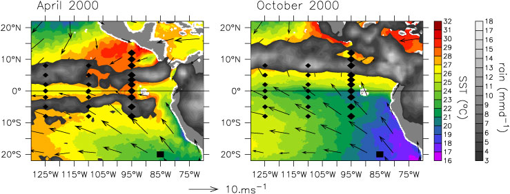
FIG. 1. EPIC mooring array shown in relation to (left) April 2000 and (right) October 2000 TRMM Microwave Imager (TMI) sea surface temperature, TRMM rain rate, and Quick Scatterometer (QuikSCAT) surface winds. Diamonds indicate TAO buoys. Large diamonds indicate EPIC-enhanced 95°W TAO buoys. The Woods Hole IMET buoy is indicated by a large square.
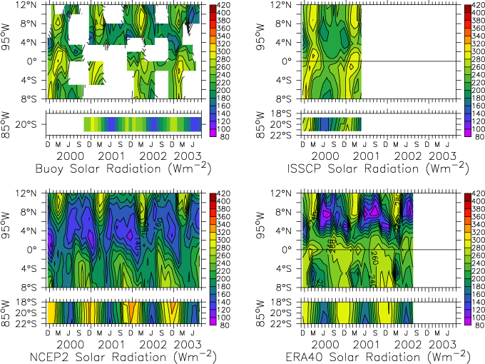
FIG. 2. Monthly averaged solar radiation incident on the surface along 95°W from 8°S to 12°N and at 20°S, 85°W from (top left) buoy measurements, (top right) ISCCP, (bottom left) NCEP2 reanalysis, and (bottom right) ERA-40. Solar radiation has units of W m![]() .
.
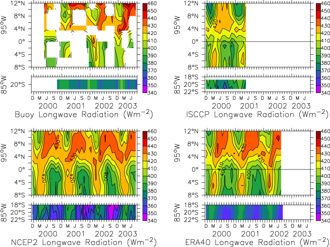
FIG. 3. Same as in Fig. 2 but for monthly averaged longwave radiation incident on the surface.
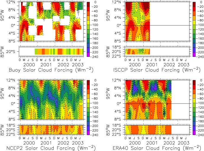
FIG. 4. Same as in Fig. 2 but for monthly averaged solar cloud forcing at the surface along 95°W from 8°S to 12°N and at 20°S, 85°W. Solar cloud forcing is defined by (1) and has units of W m![]() .
.
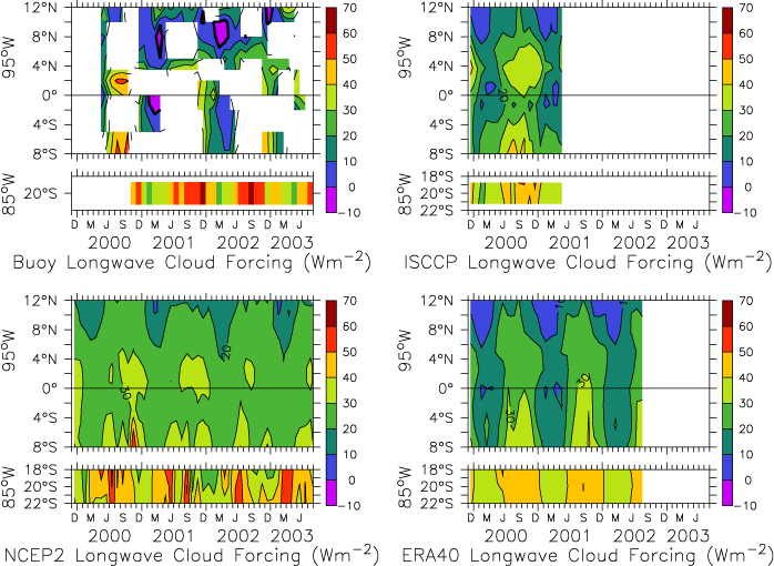
FIG. 5. Same as in Fig. 4 but for longwave cloud forcing. Longwave cloud forcing is defined by (1) and has units of W m![]() .
.
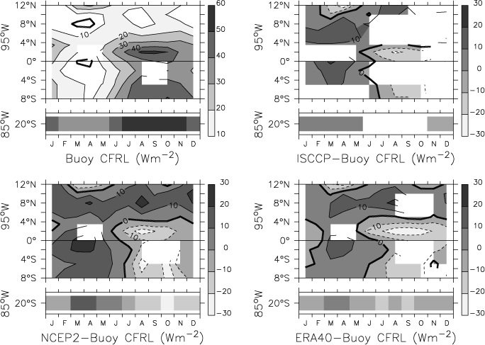
FIG. 7. Same as in Fig. 6 but for surface longwave cloud forcing.
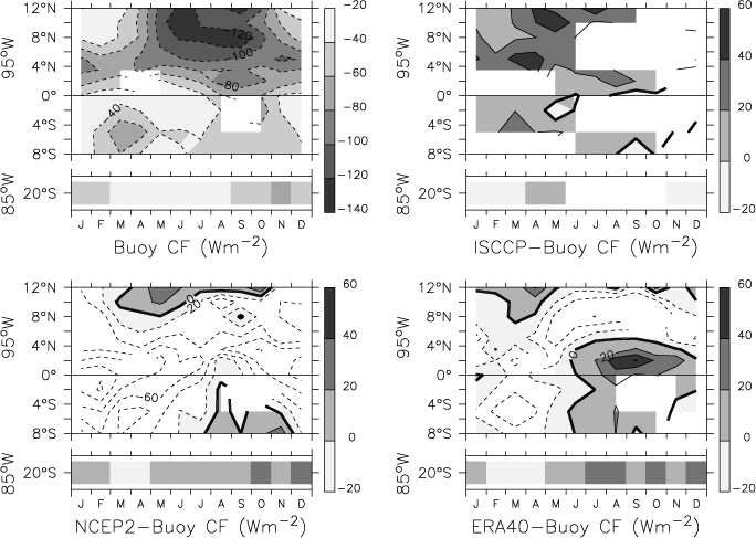
FIG. 8. Same as in Fig. 6 but for total surface cloud forcing, defined as the sum of solar and longwave cloud forcing.
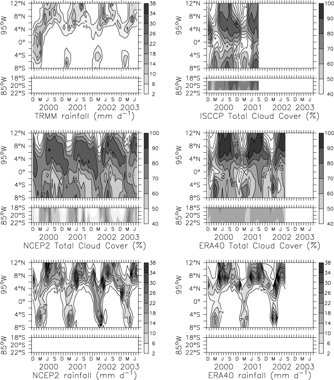
FIG. 9. Monthly averaged precipitation and total cloud cover (TCC) along 95°W from 8°S to 12°N and at 20°S, 85°W: (top left) TRMM rain rate, (top right) ISCCP TCC, (middle left) NCEP2 TCC, (middle right) ERA-40 TCC, (bottom left) NCEP2 rain rate, and (bottom right) ERA-40 rain rate. Precipitation units of mm day![]() ; TCC is unitless and scales from 0 (no clouds) to 1 (full cloud coverage).
; TCC is unitless and scales from 0 (no clouds) to 1 (full cloud coverage).
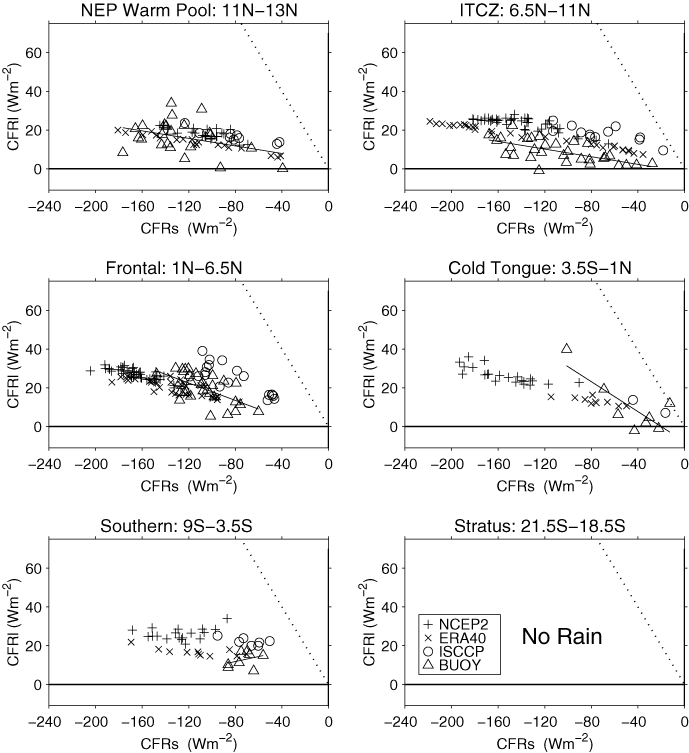
FIG. 10. Scatterplots of monthly averaged longwave cloud forcing vs solar cloud forcing for precipitating clouds in six latitudinal bands defined as northeast Pacific warm pool (11°–13°N, 95°W), ITCZ (6.5°–11°N, 95°W), frontal (1°–6.5°N, 95°W), cold tongue (3.5°S–1°N, 95°W), southern (9°–3.5°S, 95°W), and stratus (21.5°–18.5°S, 85°W). As shown in the legend in the lower left, buoy values are indicated by ![]() , NCEP2 by +, ERA40 by ×, and ISCCP by o. The negative 1–1 line is indicated by a dotted line. A thick black line extending over the range of the buoy solar cloud forcing shows the least squares straightline fit of the buoy cloud forcing values. Significant rainfall was determined by TRMM rainfall within each latitudinal bin.
, NCEP2 by +, ERA40 by ×, and ISCCP by o. The negative 1–1 line is indicated by a dotted line. A thick black line extending over the range of the buoy solar cloud forcing shows the least squares straightline fit of the buoy cloud forcing values. Significant rainfall was determined by TRMM rainfall within each latitudinal bin.
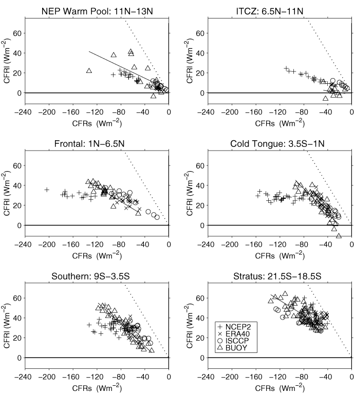
FIG. 11. Same as in Fig. 10 but for months with no significant rainfall.
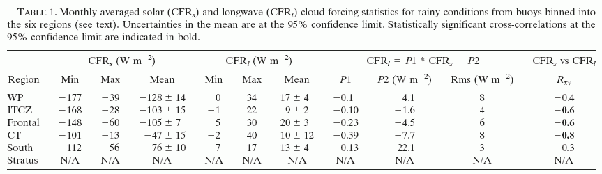
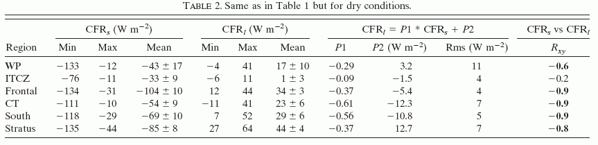
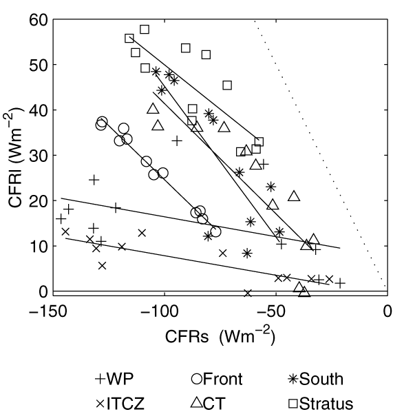
FIG. 12. Scatterplots of longwave cloud forcing mean annual cycle vs solar cloud forcing mean annual cycle from buoy data in six latitudinal bands listed in Fig. 10 for all cloud types.
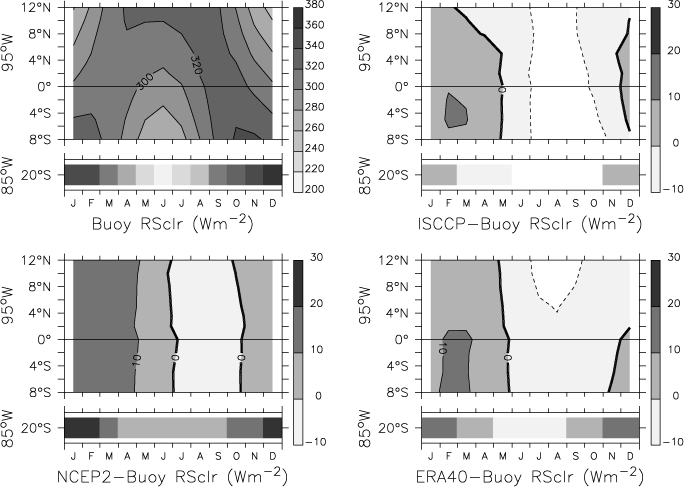
FIG. 13. Same as in Fig. 6 but for clear-sky solar radiation at the surface.
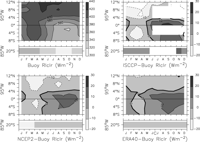
FIG. 14. Same as in Fig. 6 but for clear-sky longwave radiation at the surface.
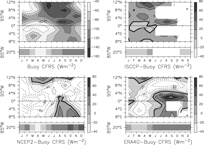
FIG. 6. (upper left) Mean annual cycle of solar cloud forcing field along 95°W from 8°S to 12°N and at 20°S, 85°W from buoy measurements and mean annual cycle of difference between surface solar cloud forcing and buoy field along 95°W from 8°S to 12°N and at 20°S, 85°W for (upper right) ISCCP, (lower left) NCEP2 reanalysis, and (lower right) ERA40.
Return to previous section or return to Abstract