U.S. Dept. of Commerce / NOAA / OAR / PMEL
/ Publications
The upper ocean heat balance in the western equatorial Pacific warm pool during
September-December 1992
Meghan F. Cronin and Michael J. McPhaden
Pacific Marine Environmental Laboratory, NOAA, Seattle, Washington
Journal of Geophysical Research, 102(C4), 8533-8553 (1997)
This paper is not subject to U.S. copyright. Published in 1997 by the American Geophysical
Union.
4. Results
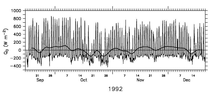
The heat fluxes are quite sensitive to variability in the wind speed (Tables
2-4) and therefore naturally group into a period before the westerly wind burst
from the beginning of the deployment to October 17, a westerly wind burst period
from October 18 to November 12, and a period following the wind burst from November
13 to December 7. Toward the end of the record, near December 8, another westerly
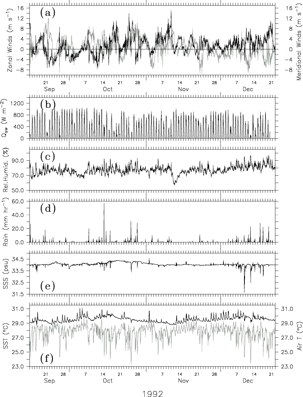
wind burst began to develop (Figure 3a), but
did not reach full strength until after the end of the deployment [Gutzler
et al., 1994; Chen
et al., 1996; Weller
and Anderson, 1996].
4.1. September 19 to October 17, 1992
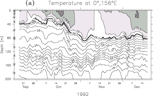
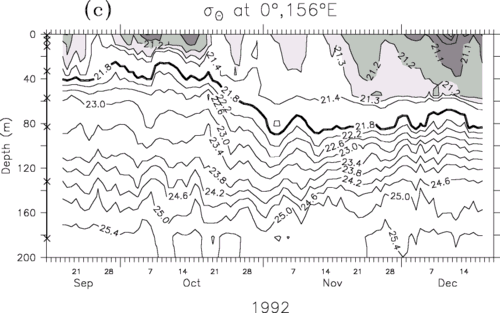
From the beginning of the record until mid-October, the top of the thermocline
was quite shallow (Figure 4a), with the upper
layer depth (depth of the 21.8  surface)
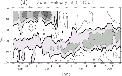
generally between 20 and 40 m. Above the shallow pycnocline, the surface zonal
flow was westward (Figure 4d), associated with
the South Equatorial Current. The surface meridional flow was characterized
by ~15-day wavelike changes in speed and direction, with northward surface flow
occurring during two southerly wind episodes.
surface)
generally between 20 and 40 m. Above the shallow pycnocline, the surface zonal
flow was westward (Figure 4d), associated with
the South Equatorial Current. The surface meridional flow was characterized
by ~15-day wavelike changes in speed and direction, with northward surface flow
occurring during two southerly wind episodes.
Between the two southerly wind episodes, there was nearly two weeks (September
25 to October 7) of relatively light wind and cloudless days during which the
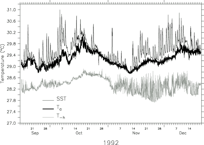
SST at 1 m depth had a strong diurnal cycle, varying by more than 1°C over the
course of the day (Figure 7). During this quiescent
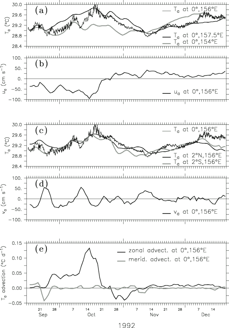
period, the warm pool had a strong temperature gradient with higher SSTs east
of 0°, 156°E (Figure 8a), and consequently the
zonal heat advection at 0°, 156°E was nearly as large as the net surface heat
flux (Figures 8e and 9).
During the period October 8-17, extended cloudiness and moderate winds caused
the surface heat flux to be near zero (Figure 6).
The upper layer, however, continued to warm by almost 0.8°C (Figure
7) due to extremely strong westward warm heat advection (Figures
8e and 9). Thus, as summarized in Figure
10a, during the period from September 19 to October 17, 1992, the upper
ocean was warmed locally by shortwave radiation and by heat advection from the
east and was to a lesser extent cooled by latent heat loss and vertical mixing.
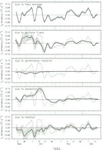
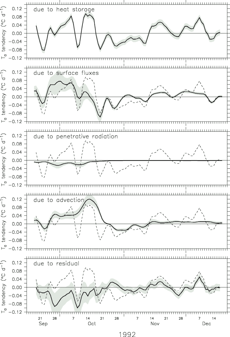
Figure 9. The 5-day triangular filtered surface layer heat balance
in units of degrees Celcius per day. The heat storage rate ( Ta/t)
is repeated as a dashed line in each panel. The ±1 rms error for each term is
indicated by the shading.
Ta/t)
is repeated as a dashed line in each panel. The ±1 rms error for each term is
indicated by the shading.
4.2. October 18 to November 12, 1992
In mid-October a series of three to four strong southwesterly wind episodes
occurred, each with wind speeds of roughly 7-8 m s .
Outgoing longwave radiation (OLR) observations [Gutzler
et al., 1994; Chen
et al., 1996] show that the increased cloudiness extended over 15°-20°
of longitude and propagated eastward at approximately 1.5 m s.
These combined southwesterly episodes spanned approximately 26 days during which
the SST cooled by over 1°C. This period will be referred to hereafter as "the
October wind burst."
.
Outgoing longwave radiation (OLR) observations [Gutzler
et al., 1994; Chen
et al., 1996] show that the increased cloudiness extended over 15°-20°
of longitude and propagated eastward at approximately 1.5 m s.
These combined southwesterly episodes spanned approximately 26 days during which
the SST cooled by over 1°C. This period will be referred to hereafter as "the
October wind burst."
As a result of the decreased shortwave radiation and the enhanced latent heat
loss, surface cooling occurred during daytime as well as nighttime. Persistent
westerly winds accelerated the surface currents such that by the end of October,
the surface equatorial jet completely reversed direction to become eastward.
Consequently, the heat advection became a cooling process. As the warm advection
decreased and the surface cooling increased, the SST began to steadily cool.
During this cooling period, the SST diurnal cycle was suppressed; SST was nearly
identical to (and for several particularly rainy hours even cooler than) the
vertically averaged upper layer temperature (Figure
7).
As shown in Figure 4c, the ocean response to
the westerly wind burst also included a deepening of the pycnocline of over
50 m. Analyses of the mass balance indicate that this deepening was due primarily
to meridional Ekman convergence in the surface layer [R. Weisberg, personal
communication, 1996] rather than to turbulent mixing. The slight warming in
the residual term during October 21-25 cannot represent mixing since the thermocline
was stably stratified. Thus during this westerly wind burst period from October
18 to November 12, 1992, the upper ocean cooled due to a net surface heat loss
and to a lesser extent due to vertical mixing and eastward advection of cooler
water (Figure 10b).
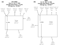
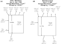
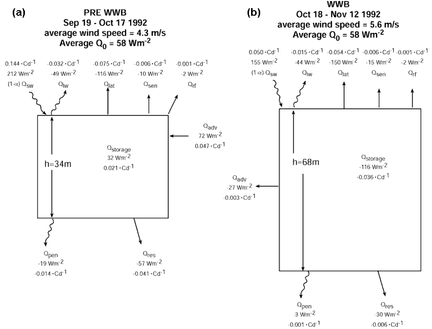
Figure 10. Box diagrams of the heat balance (equations (2a) and (2b))
for (a) the pre-wind burst period from September 19 to October 17, 1992, (b)
the wind burst period from October 18 to November 12, 1992, (c) the post-wind
burst period from November 13 to December 7, 1992, and (d) the beginning of
the December wind burst from December 8 to 17, 1992. The mean wind speed during
each period is listed, and the mean layer depth is indicated in the boxes. As
discussed in the text, although we generally interpret the residual in terms
of entrainment mixing, during the post-wind burst period the residual is positive
and therefore cannot represent mixing. Instead, we believe that during this
period it may represent horizontal advection of a sharp temperature front.
4.3. November 13 to December 7, 1992
From mid-November through mid-December, winds were generally light (less than
4 m s), shortwave radiation was near the
clear-sky value, and precipitation was negligible. As shown in Figures
6 and 9, shortwave radiative warming dominated
over surface cooling fluxes. Likewise, as shown in Figure
8, the zonal temperature gradient and therefore heat advection changed sign,
becoming warm advection from the west. As a result of these warming processes,
the surface layer began to warm (Figures 9 and
10c).
During this post-wind burst period, the top of the pycnocline was quite deep
(i.e., below 80 m). Near-surface restratification in the thermal field was evident
in the latter part of November. However, higher salinity near the surface compensated
for the thermal stratification, and consequently near-surface restratification
is less evident in the density field. Thus the primary effect of this thermal
restratification was to make the vertically averaged surface layer temperature,
Ta, less of a SST proxy.
The intense December 5-7 warming in the residual (Figure
9) cannot be due to entrainment mixing because the temperature field associated
with the pycnocline was stably stratified. Since there was both near-surface
stratification and shear, it could possibly be due in part to the unresolved
terms in (2) involving  .
Alternatively, the intense warming event could be due to the passage of a sharp
temperature front that was not adequately resolved by the mooring array. As
shown in Figure 8a, prior to December 5 the surface
layer temperatures at 0°, 156°E and 0°, 157.5°E were nearly identical and were
both approximately 0.4°C cooler than the surface layer water to the west at
0°, 154°E. Then, over the course of 3-4 days, the temperature of the surface
layer at 0°, 156°E increased by 0.4°C to become nearly identical to the temperature
at 0°, 154°E. With a 20 cm s zonal current,
a 0.4°C temperature change in 4 days corresponds to the passage of a front across
which temperature changes by 0.5°C in 70 km. Sharp fronts (0.4°C in 40 km) were
observed near 2°S, 156°E during COARE [Henin
et al., 1994]; however, further analysis of COARE data is needed to
determine if this large warming event at 0°, 156°E can be conclusively attributed
to zonal advection of a sharp temperature front.
.
Alternatively, the intense warming event could be due to the passage of a sharp
temperature front that was not adequately resolved by the mooring array. As
shown in Figure 8a, prior to December 5 the surface
layer temperatures at 0°, 156°E and 0°, 157.5°E were nearly identical and were
both approximately 0.4°C cooler than the surface layer water to the west at
0°, 154°E. Then, over the course of 3-4 days, the temperature of the surface
layer at 0°, 156°E increased by 0.4°C to become nearly identical to the temperature
at 0°, 154°E. With a 20 cm s zonal current,
a 0.4°C temperature change in 4 days corresponds to the passage of a front across
which temperature changes by 0.5°C in 70 km. Sharp fronts (0.4°C in 40 km) were
observed near 2°S, 156°E during COARE [Henin
et al., 1994]; however, further analysis of COARE data is needed to
determine if this large warming event at 0°, 156°E can be conclusively attributed
to zonal advection of a sharp temperature front.
As summarized in Figure 10c, warming during
this post-wind burst period from November 13 to December 7, 1992, was caused
by strong surface heat flux into the ocean and by warm eastward heat advection.
Unlike during the pre-wind burst period when the pycnocline was shallow, mixing
of cold (deep) pycnocline water into the upper ocean layer was negligible during
the post-wind burst period.
4.4. December 8 to December 17, 1992 (End of Record)
On December 11, a short 3-day northwesterly wind burst occurred, and the surface
layer temperature cooled due to the combined reduction in insolation, increase
in latent heat loss, and increase in the residual processes (turbulent mixing).
Prolonged precipitation events caused cool, freshwater anomalies in the surface
(1 m) salinity, and associated subsurface temperature maxima at 10 m depth.
The pycnocline, however, was located at approximately 60 m, well below the shallow
subsurface temperature maximum (Figure 4a),
so that the residual remained a weak cooling process. As the record ends, the
winds began intensifying into the "December wind burst" which is the
focus of much COARE research [e.g., Smyth
et al., 1996; Weller
and Anderson, 1996].
Return to previous section or go to next section
PMEL Outstanding Papers
PMEL Publications Search
PMEL Homepage