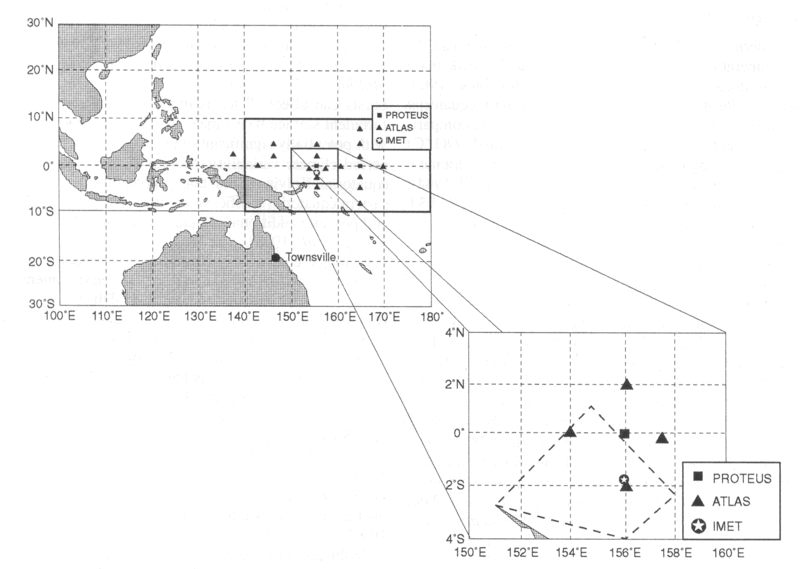
Figure 1. The enhanced monitoring array. The heat balance is estimated at the central 0°, 156°E PROTEUS mooring. The four nearest ATLAS buoys at 0°, 154°E; 0°, 157.5°E; 2°N, 156°E; and 2°S, 156°E are used to estimate horizontal temperature gradients. The 0°, 156°E PROTEUS mooring is on the northern edge of the COARE intensive flux array (dashed region).
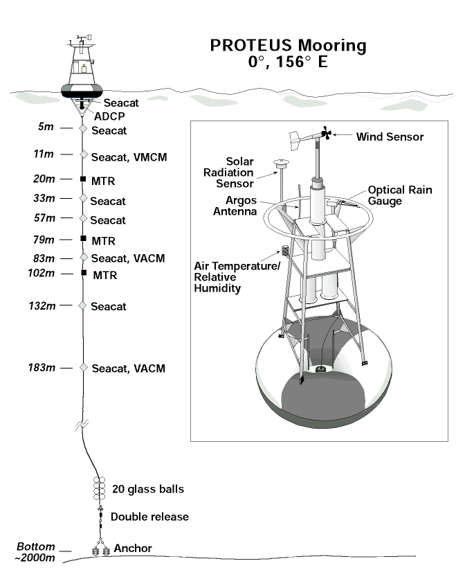
Figure 2. Diagram of the PROTEUS buoy which was deployed at 0°, 156°E from September 15 to December 20, 1992. The vector averaging current meters (VACMs) are located 1 m above the listed SEACAT depths.
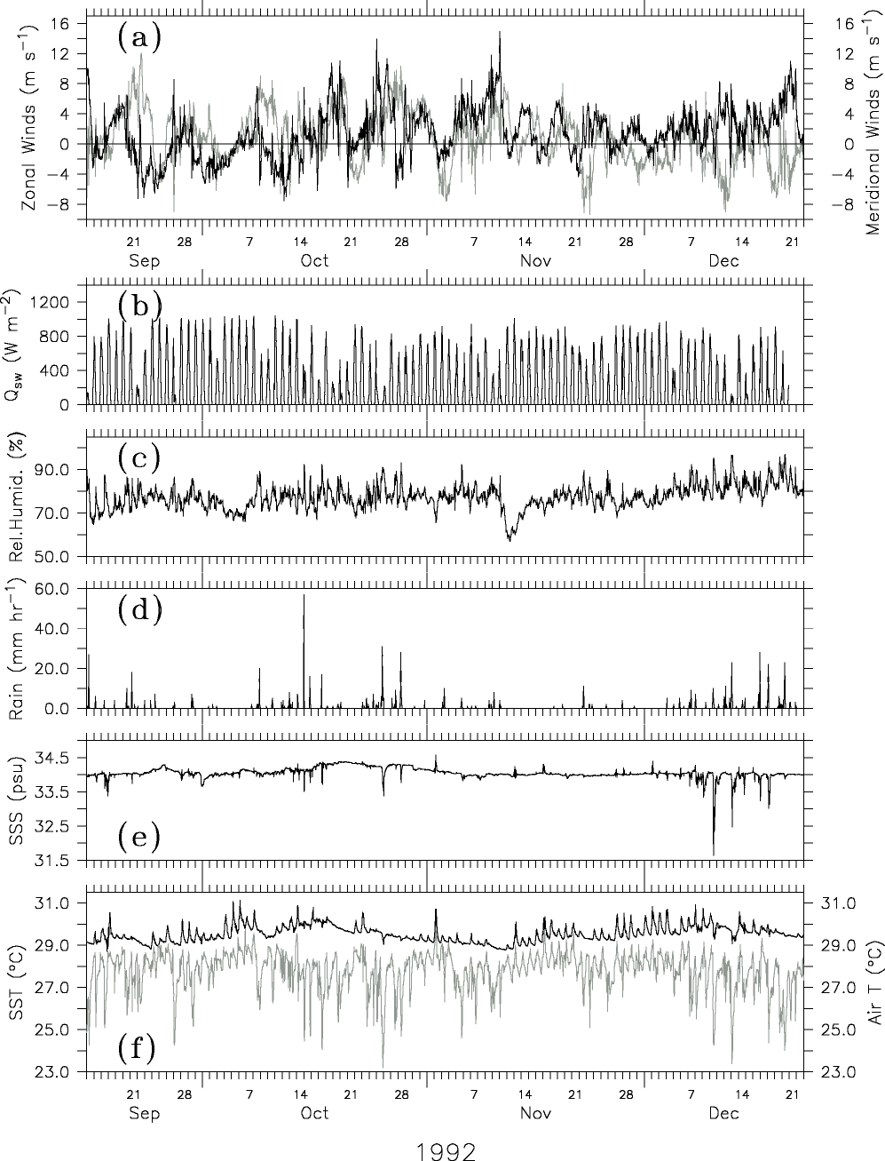
Figure 3. Hourly surface data: (a) eastward (dark line) and northward (light line) winds, (b) shortwave radiation, (c) relative humidity, (d) rain, (e) 1-m sea surface salinity (SSS), and (f) air temperature (light line) and 1-m sea surface temperature (SST) (dark line).
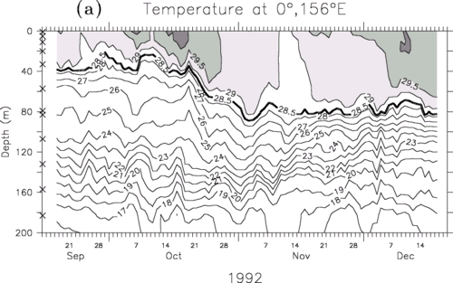
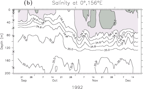
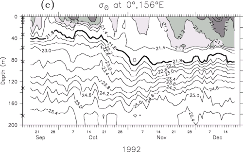
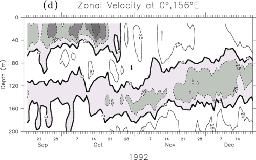
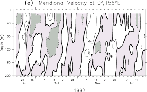
Figure 4. Daily averaged subsurface (a) temperature, (b) salinity, (c)
potential density, (d) ADCP zonal flow, and (e) meridional flow. The surface layer is
defined as the depth of the 21.8 kg m density surface
(ATLAS moorings use the 28.5°C isotherm as the surface layer depth). The subsurface
temperature contour interval (CI) is 1°C for values less than 28°C and 0.5°C for warmer
values. The salinity CI is 0.2 psu. The density CI is 0.1 kg m for values less than 21.4 kg m and 0.4 kg m for
denser values. The velocity CI is 25 cm s
density surface
(ATLAS moorings use the 28.5°C isotherm as the surface layer depth). The subsurface
temperature contour interval (CI) is 1°C for values less than 28°C and 0.5°C for warmer
values. The salinity CI is 0.2 psu. The density CI is 0.1 kg m for values less than 21.4 kg m and 0.4 kg m for
denser values. The velocity CI is 25 cm s . Westward
and southward directed currents are contoured with dashes.
. Westward
and southward directed currents are contoured with dashes.
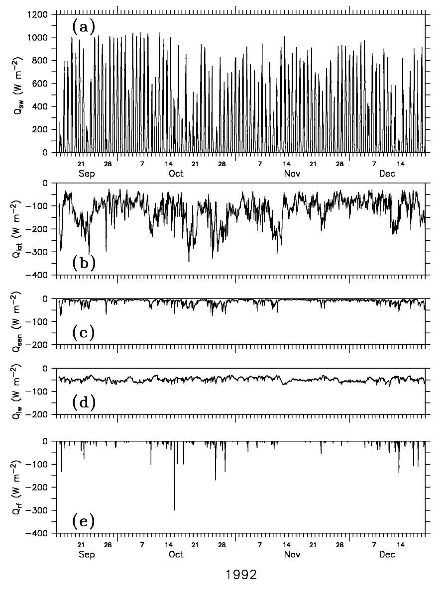
Figure 5. Hourly air-sea heat fluxes. (a) Shortwave radiation, Qsw,
(b) latent heat flux, Q , (c) sensible
heat flux, Q
, (c) sensible
heat flux, Q , (d) net longwave
radiation, Qlw, and (e) sensible heat flux due to rain, Qrf.
, (d) net longwave
radiation, Qlw, and (e) sensible heat flux due to rain, Qrf.
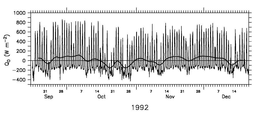
Figure 6. Hourly and 5-day triangular filtered net surface heat flux. A positive flux value represents a heat flux into the ocean.
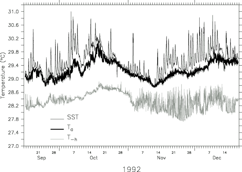
Figure 7. Hourly time series of the vertically averaged surface layer
temperature (Ta), SST at 1 m depth, and the temperature at the base of
the surface layer (Th, where the base of the surface layer is defined as
the depth of the 21.8 kg m density surface).
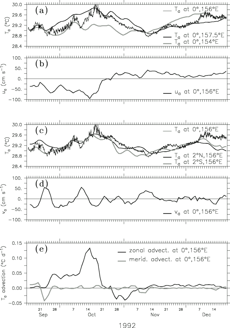
Figure 8. Horizontal heat advection at 0°, 156°E. Daily averaged time series of the (a) vertically averaged surface layer temperatures along the equator at 0°, 154°E; 0°, 156°E; and 0°, 157.5°E and (b) vertically averaged zonal velocity at 0°, 156°E. Daily averaged time series of the (c) vertically averaged temperatures along the 156°E longitude at 2°N, 156°E; 0°, 156°E; and 2°S, 156°E and (d) vertically averaged meridional velocity at 0°, 156°E. (e) Daily estimates of the zonal and meridional heat advection.
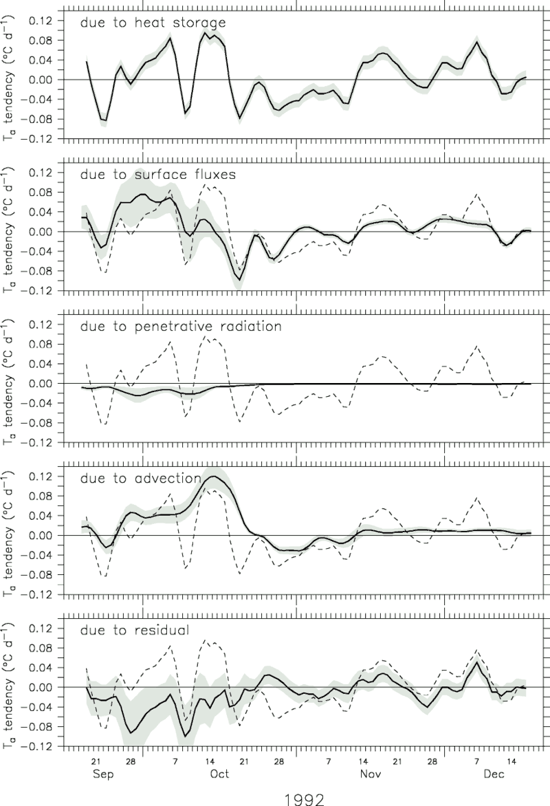
Figure 9. The 5-day triangular filtered surface layer heat balance in units of
degrees Celcius per day. The heat storage rate ( Ta/t) is repeated as a dashed line in each panel. The ±1
rms error for each term is indicated by the shading.
Ta/t) is repeated as a dashed line in each panel. The ±1
rms error for each term is indicated by the shading.
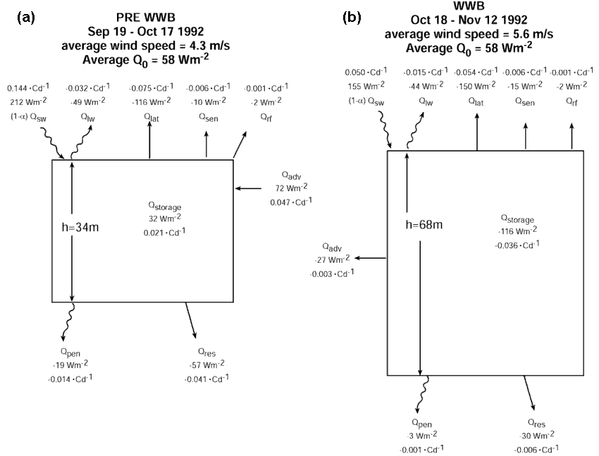
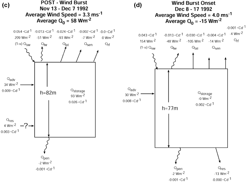
Figure 10. Box diagrams of the heat balance (equations (2a) and (2b)) for (a) the pre-wind burst period from September 19 to October 17, 1992, (b) the wind burst period from October 18 to November 12, 1992, (c) the post-wind burst period from November 13 to December 7, 1992, and (d) the beginning of the December wind burst from December 8 to 17, 1992. The mean wind speed during each period is listed, and the mean layer depth is indicated in the boxes. As discussed in the text, although we generally interpret the residual in terms of entrainment mixing, during the post-wind burst period the residual is positive and therefore cannot represent mixing. Instead, we believe that during this period it may represent horizontal advection of a sharp temperature front.
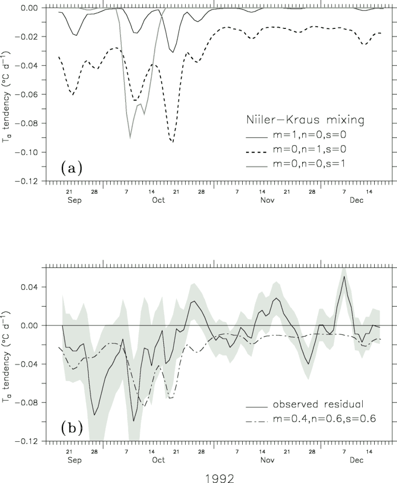
Figure 11. (a) Niiler and Kraus's [1977] parameterization of the entrainment mixing rate for the three cases of pure wind-generated turbulence (m = 1, n = 0, s = 0), pure free convection (m = 0, n = 1, s = 0), and pure shear-generated turbulence (m = 0, n = 0, s = 1). (b) Time series of the heat balance residual (solid curve) and the optimized Niiler-Kraus entrainment mixing rate (m = 0.4, n = 0.6, s = 0.6) (dashed curve). The heat balance residual includes entrainment mixing, diffusion, heat convergence due to the stratified and shear flow, and errors. The rms error of the observed residual is indicated by shading.
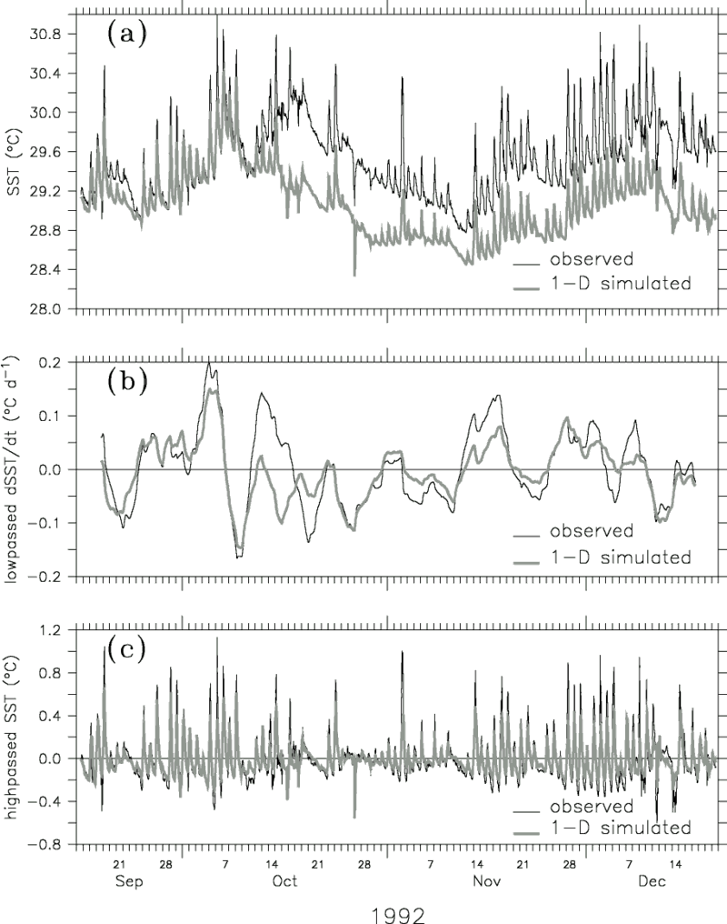
Figure 12. Price-Weller-Pinkel one-dimensional mixed layer simulation at 0°, 156°E from September 17 to December 20, 1992. (a) Observed SST (thin curve) and simulated SST (thick curve) at 1 m depth. (b) The 5-day triangular filtered observed SST tendency rate (thin curve) and simulated SST tendency rate (thick curve). (c) The 5-day high-passed SST (thin curve) and simulated SST (thick curve).
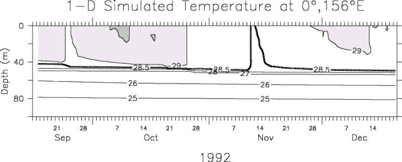
Figure 13. Daily averaged PWP simulated temperature stratification. The CIs are the same as in Figure 4a.

Figure 14. Time-longitude plot of the Reynolds et al. [1994] SST from January 1991 through December 1994, along the equator (average of 0.5°S and 0.5°N) from 140°E to 110°W. The study period is highlighted by a line along the left edge of the time axis. Likewise the study region is highlighted by line through the contoured time series at 0°, 156°E. The CI is 1°C and 0.5°C for SST values less than and greater than 28°C, respectively. The 28.5°C contour (dark line) indicates the boundary of the warm pool.
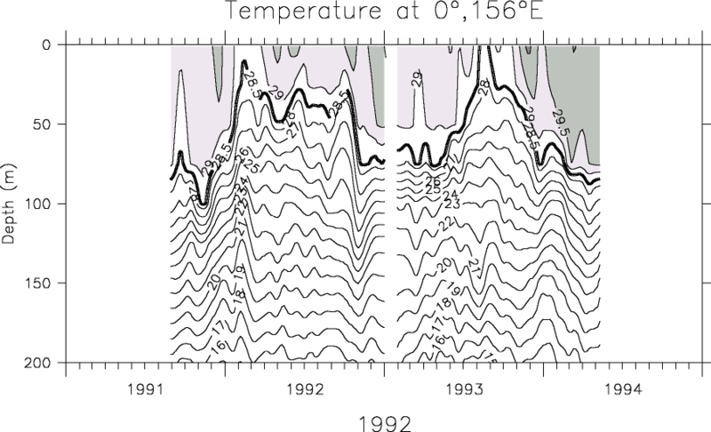
Figure 15. Time series of the subsurface temperature profile at 0°, 156°E. Data have been low passed with a 29-day triangular filter. The CIs are the same as in Figure 4a.
Table 1. Subsurface PROTEUS Instrumentation Used in This Analysis
| Depth | Instrument | Variable | Record start and end dates |
| bridal | ACDP | u, v | Sept. 15 to Dec. 24, 1992 |
| 1 | SEACAT | T, S | Sept. 15 to Dec. 24, 1992 |
| 5 | SEACAT | T, S | Sept. 15 to Dec. 24, 1992 |
| 10 | VAC | u, v | Sept. 15 to Dec. 24, 1992 |
| 11 | SEACAT | T, S | Sept. 15 to Dec. 24, 1992 |
| 20 | MTR | T | Nov. 5 to Dec. 13, 1992 |
| 33 | SEACAT | T, S | Sept. 15 to Dec. 20, 1992 |
| 57 | SEACAT | T, S | Sept. 15 to Dec. 20, 1992 |
| 79 | MTR | T | Nov. 5 to Dec. 13, 1992 |
| 82 | VACM | u, v | Sept. 15 to Dec. 20, 1992 |
| 83 | SEACAT | T, S | Sept. 15 to Dec. 20, 1992 |
| 107 | MTR | T | Sept. 15 to Dec. 20, 1992 |
| 132 | SEACAT | T, S | Sept. 15 to Dec. 20, 1992 |
| 182 | VACM | u, v | Sept. 15 to Dec. 20, 1992 |
| Depths represent best estimates of actual depth. Variables measured include temperature (T), salinity (S), and zonal (u) and meridional (v) velocity. | |||
Table 2. Standard Deviations of the 5-Day Triangular Filtered Surface Measurements, Typical Measurement Errors, and Resulting Errors in Bulk Fluxes
| Instrument | Variable |
5-Day Filtered Std Dev |
Typical Error |
Corresponding rms Error, W m |
|||
| Q |
Q |
Qrf | Q |
||||
| RM Young | winds | 1.41 m s |
0.20 m s |
4.7 | 0.5 | 0.1 | 5.1 |
| Rotronics | air temperature | 0.38°C | 0.16°C | 0.6 | 1.3 | 0.2 | 1.8 |
| Rotronics | relative humidity | 0.03 | 0.02 | 9.2 | 0.1 | 0.6 | 9.2 |
| SEACAT | SST | 0.30°C | 0.014°C | 0.4 | 0.1 | 0.0 | 0.5 |
| ORG | rain rate | 0.37 mm h |
25% | 0.0 | 0.0 | 2.9 | 2.9 |
| Eppley | Qsw | 40 W m |
2-3.5% | 0.2-0.3 | 0.1 | 0.0 | 6.4-11.3 |
| The 2% error in the shortwave radiation, Qsw, is the standard error assuming the radiometer mast is vertical. This error increases to a maximum of 3.5% if the mast is tilted 15° from the vertical. To estimate the upper and lower limits of the resulting flux errors, the bulk heat flux algorithm was run with the observed variables with plus and minus typical errors. One half the rms difference between the upper and lower limit is listed as the corresponding rms error in the heat flux due to a typical error in the bulk parameter. | |||||||
| Table 3. Record Length Means, Standard Deviations of the 5-Day Triangular Filtered Fluxes, rms Error, and Cross Correlations Between 5-Day Filtered Fluxes and 5-Day Filtered Wind Speed | ||||
| Heat Flux | Mean, W m |
5-Day Filtered Std Dev, W m |
rms Error, W m |
5-Day Filtered Correlation with Wind Speed |
(1- )Qsw )Qsw |
189 | 38 | 6.6-11.5 | -0.57 |
| Qlw | -48 | 5 | 6 | 0.70 |
| Q |
-118 | 34 | 10.3 | -0.93 |
| Q |
-11 | 5 | 1.4 | -0.69 |
| Qrf | -2 | 2 | 3.0 | -0.32 |
| Q |
10 | 68 | 14.2-16.9 | -0.80 |
| Table 4. Record Length Means and Standard Deviations of the 5-Day Triangular Filtered Fluxes, rms Error, and Cross Correlations Between the 5-Day Filtered Fluxes and 5-Day Filtered Wind Speed | ||||
| Heat Flux | Mean, W m |
5-Day Filtered Std Dev, W m |
rms Error, W m |
5-Day Filtered Correlation with Wind Speed |
| Qstorage | -3 | 113 | 46 | -0.74 |
| Q0 | 10 | 68 | 14-17 | -0.80 |
| Qpen | 8 | 8 | 8 | -0.08 |
| Qadvect | 28 | 68 | 31 | -0.47 |
| Qres | -33 | 59 | 57-58 | -0.04 |
Qstorage is the lhs of (2b), Q is the net surface heat flux (1), Q is the penetrative radiation (3), Qadvect
is the horizontal advective heat flux (- is the penetrative radiation (3), Qadvect
is the horizontal advective heat flux (- cp h
va cp h
va   Ta), and Qres is the
residual of the budget, computed as Qstorage - (Q - Q) - Qadvect. Ta), and Qres is the
residual of the budget, computed as Qstorage - (Q - Q) - Qadvect.
|
||||
Return to References or go back to Abstract