U.S. Dept. of Commerce / NOAA / OAR / PMEL / Publications
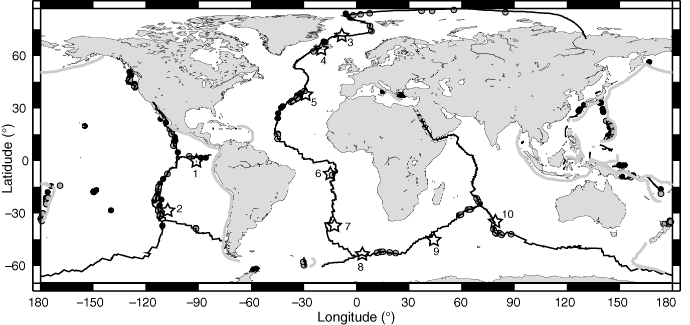
Figure 1a. Distribution of 144 known (black dots) and 133 inferred (gray dots) hydrothermal fields. Some individual fields contain several closely spaced (~100 m) "sites" distinctly named in the literature. Solid black lines are the midocean ridge and transform faults, gray lines are subduction zones. Hotspots (open stars) on or near (<500 km) the midocean ridge include 1, Galápagos; 2, Easter; 3, Jan Mayen; 4, Iceland; 5, Azores; 6, Ascension; 7, Tristan de Cunha; 8, Bouvet; 9, Crozet; and 10, Amsterdam-St. Paul.
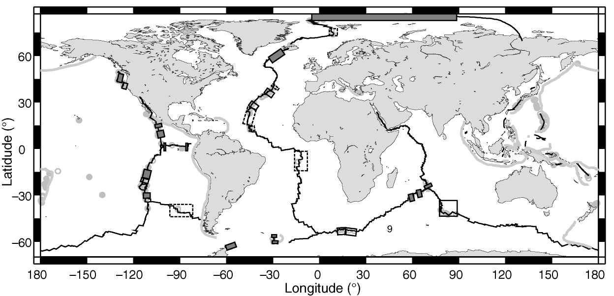
Figure 1b. Vent site distribution overlain with boxes indicating the quality of existing survey data along oceanic spreading ridges: densely surveyed (solid boxes), moderately well surveyed (open boxes), or sparsely surveyed (dotted line boxes).
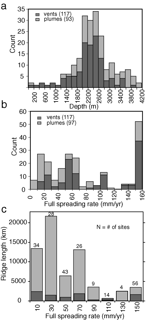
Figure 2. (a) Frequency distribution of the depth of vent sites located along midocean ridge and back-arc basin spreading centers. (b) Frequency distribution of the full spreading rate at the vent site locations. (c) Frequency distribution for the full spreading rate of the global spreading center system in 20 mm/yr increments [DeMets et al., 1990; Bird, 2003]. Numbers above each bar indicate the number of vent+plume sites in each spreading rate category. Dark bars at the bottom of each column indicate the approximate length of densely surveyed plus moderately surveyed ridge axis (from Figure 1b) in each spreading rate bin. This total includes more ridge sections than used in Table 1.
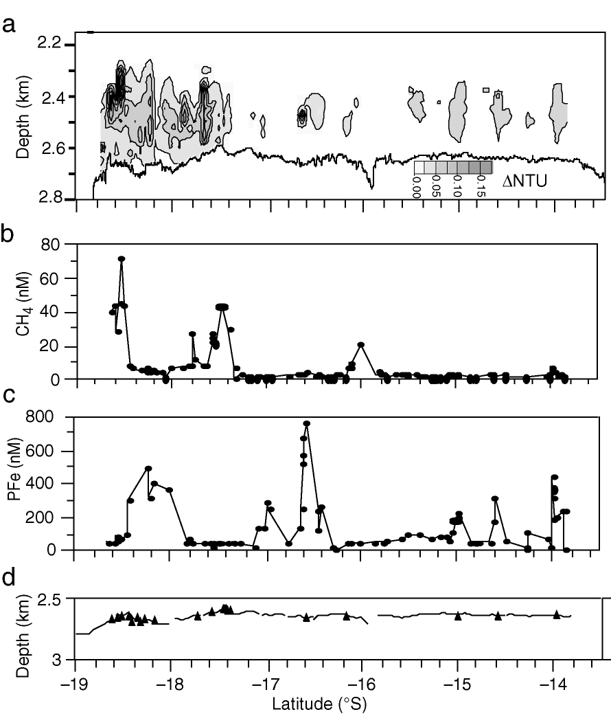
Figure 3. Along-axis transect of (a) light-scattering, (b) dissolved CH , and (c) particulate Fe from 13.5° to 18.67°S on the East Pacific Rise. Light-scattering data collected with a series of continuous CTDO tow-yos. Discrete CH and Fe samples (solid circles) from bottle samples and vertical casts. Note that some plumes are volatile rich (e.g., near 18.5°S and 17.67°), while others are metal rich (e.g., near 18°, 16.5°, and 14°S). Location of known vent areas (solid triangles) shown in (d).
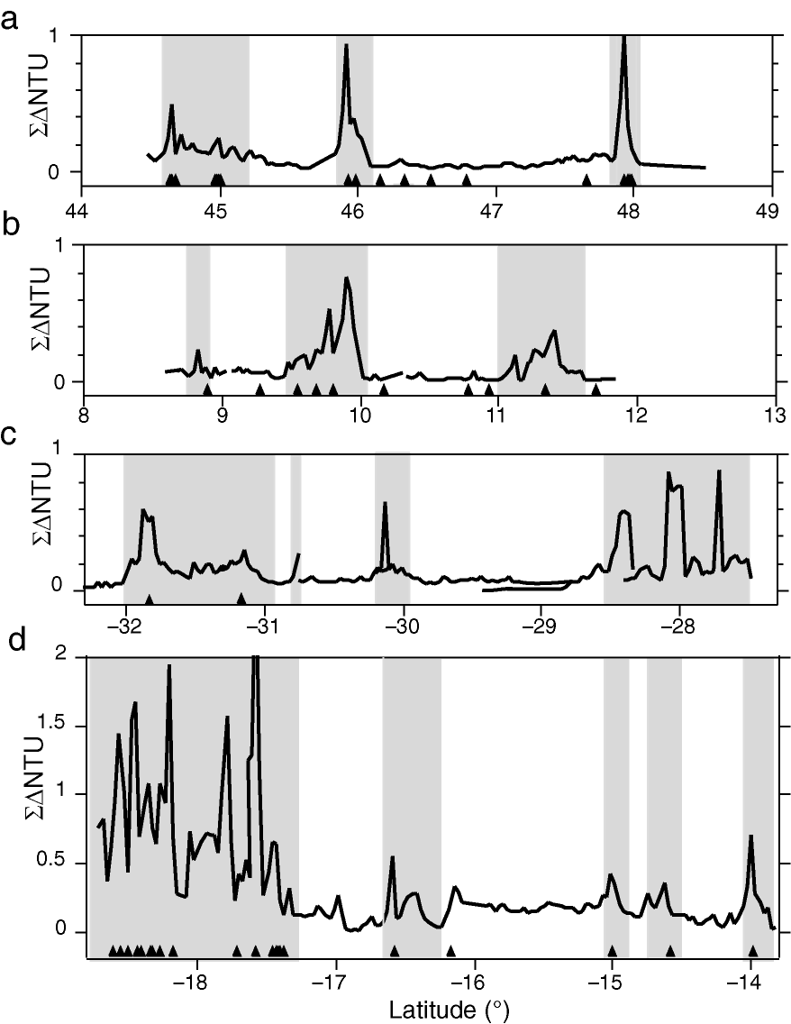
Figure 4. Vertically integrated  NTU transects from sections of fast ridges.
  NTU values were determined by gridding continuous NTU data into cells of 0.03° latitude along axis by 25 m thick from the top of the plume to the seafloor, then summing NTU values vertically in each latitude bin. Shaded areas identify regions where light-scattering plumes are continuous along axis. The fraction of the total surveyed areas covered by these regions (ph) increases with increasing spreading rate: (a) Juan de Fuca Ridge (55 mm/yr), ph = 0.23; (b) northern East Pacific Rise (103 mm/yr), ph = 0.38; (c) southern EPR (148 mm/yr), ph = 0.60; (d) southern EPR (148 mm/yr), ph = 0.54. Locations of known vent fields (solid triangles) indicated along the bottom of each transect.
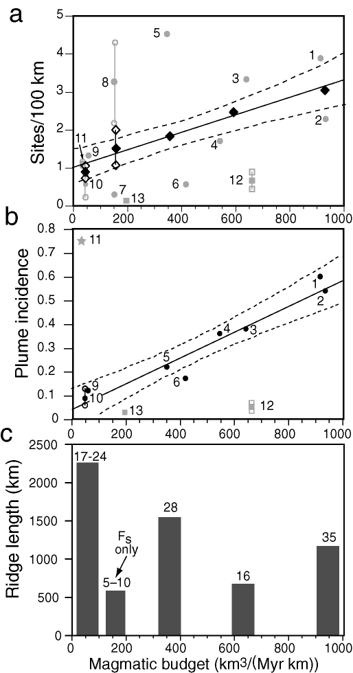
Figure 5. (a) Scatter plot of hydrothermal sites/100 km of ridge length (Fs) vs. magmatic budget (Vm). Numbers refer to ridge sections identified in Table 1. Sections 8, 10, 11, and 12 show high and low estimates with open symbols, mean estimate with solid symbol. Squares indicate hotspot-affected ridges. Black diamonds show binned data (not including sections 12 or 13), with least-squares regression fit of Fs = 1.01 + 0.0023Vm (r2 = 0.97). 95% confidence bands for prediction of Fs from Vm given by dotted lines. (b) Plume incidence (ph) vs. Vm, with symbols as in (a). Least-squares regression fit of ph = 0.043 + 0.00055Vm (r2 = 0.93), excluding sections 11–13 (see text). Note also there is no data point for slow-spreading (non-hotspot-affected) ridges. (c) Total ridge length and number of vent sites in each of the five bins in (a).
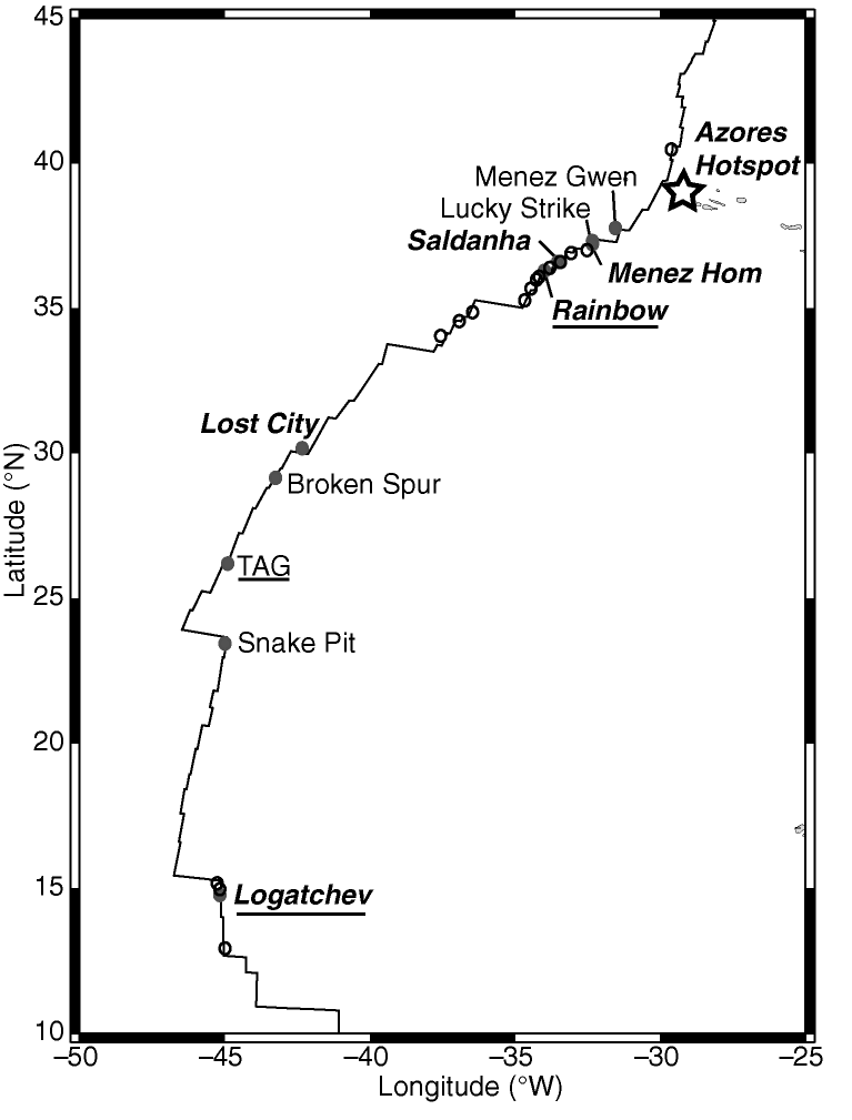
Figure 6. Known (solid circles) and inferred (open circles) vents sites along the northern Mid-Atlantic Ridge. Sites sited on axial neovolcanic highs are in plain type, sites hosted at least partially in ultramafic rocks are in italics, and sites apparently controlled by cross-cutting fault populations are underlined. Unlike the situation on most fast-spreading ridges, many of the inferred vent sites are based on single vertical profiles and have a high degree of uncertainty.
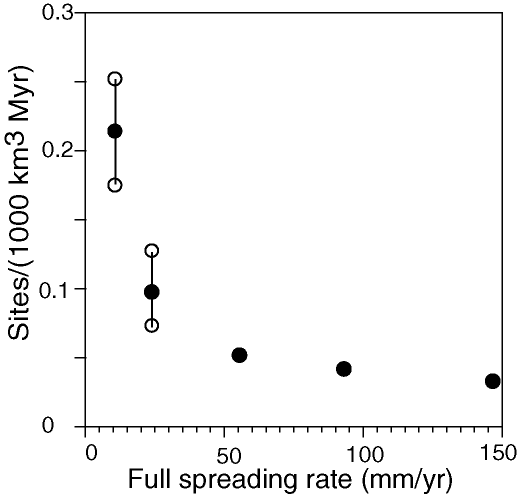
Figure 7. Site frequency Fs normalized to the magma delivery rate vs. spreading rate for the binned data in Figure 5a. Solid circles indicate mean values, open circles the uncertainty range (see Figure 5a). Approximately same trend would result using the ph data in Figure 5b (excluding the biased Gakkel Ridge result and the hotspot-affected ridge sections).
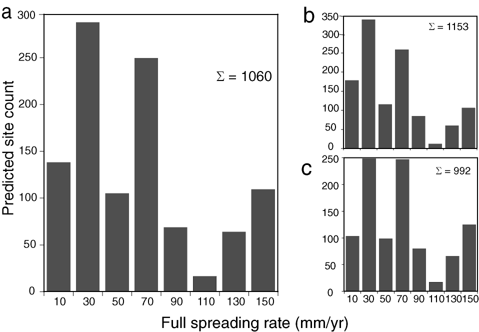
Figure 8. (a) Histogram of predicted vent site population as a function of spreading rate in 20 mm/yr bins (e.g., 0–20, 20–40, etc.). Total population on ridges is estimated as 1060. (b) and (c) show 95% confidence limits for high and low estimates, respectively.
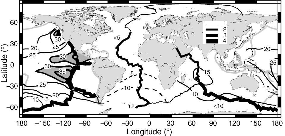
Figure 9. Deep-water (~2000–3000 m) distribution of  (
( He)% values [Geosecs Atlantic, Pacific, and Indian Ocean Expeditions, 1987; Lupton, 1995, 1998; Jamous et al., 1992; Rüth et al., 2000] compared to ridge full spreading rates ((He)% = 100(R/R
 – 1); R = He/
 He). Areas with (He)% values >30 are shaded. The MOR is divided into four rate categories corresponding to increasing line thickness: 1, <20 mm/yr; 2, 20–<50 mm/yr; 3, 50–100 mm/yr; 4, >100 mm/yr.
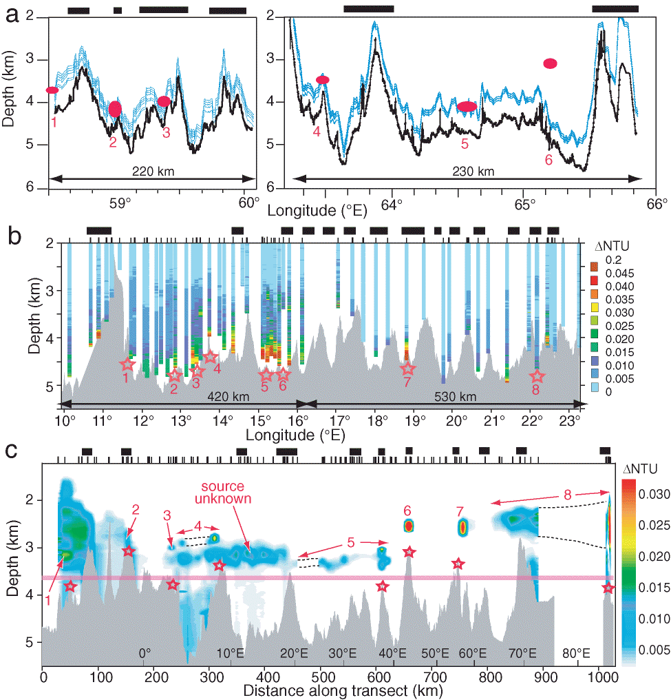
Plate 1. Along-axis transects of NTU for the (a) SWIR 58.5°–66°E, (b) SWIR 10°–23°E, and (c) Gakkel Ridge (4°W–86°E). Black bars above each panel show approximate location of volcanic centers [Grindlay et al., 1998; Sauter et al., 2002; Cannat et al., 2003; Dick et al., 2003; Michael et al., 2003]. In (a) the MAPR paths (light blue) intersected six incidences of NTU (red symbols) while following the bathymetry (heavy black line).This diagram shows only one of two parallel tracks; the plume at 65.12°E was detected on the other track, which followed a slightly different bathymetry. In (b) NTU data are displayed as individual profiles to avoid contouring artifacts. Not all casts were made at the rift axis, so profile depths may be deeper or shallower than the bathymetric profile at the same longitude. Stars mark sites where hydrothermal activity is probable. In (c) MAPR data was sufficiently dense to contour [Baker et al., 2004]. Numbers mark individual plumes and the possible seafloor source location of each is shown by the underlying stars; source location of the extensive plume from 250–450 km along section, centered at ~3200 m, is unknown. Most of the NTU anomaly west of ~150 km has no thermal expression and is thus nonhydrothermal [Baker et al., 2004]. Supplementary x-axis scale gives longitude along the transect. Pink line indicates approximate top of the bottom isopycnal layer.
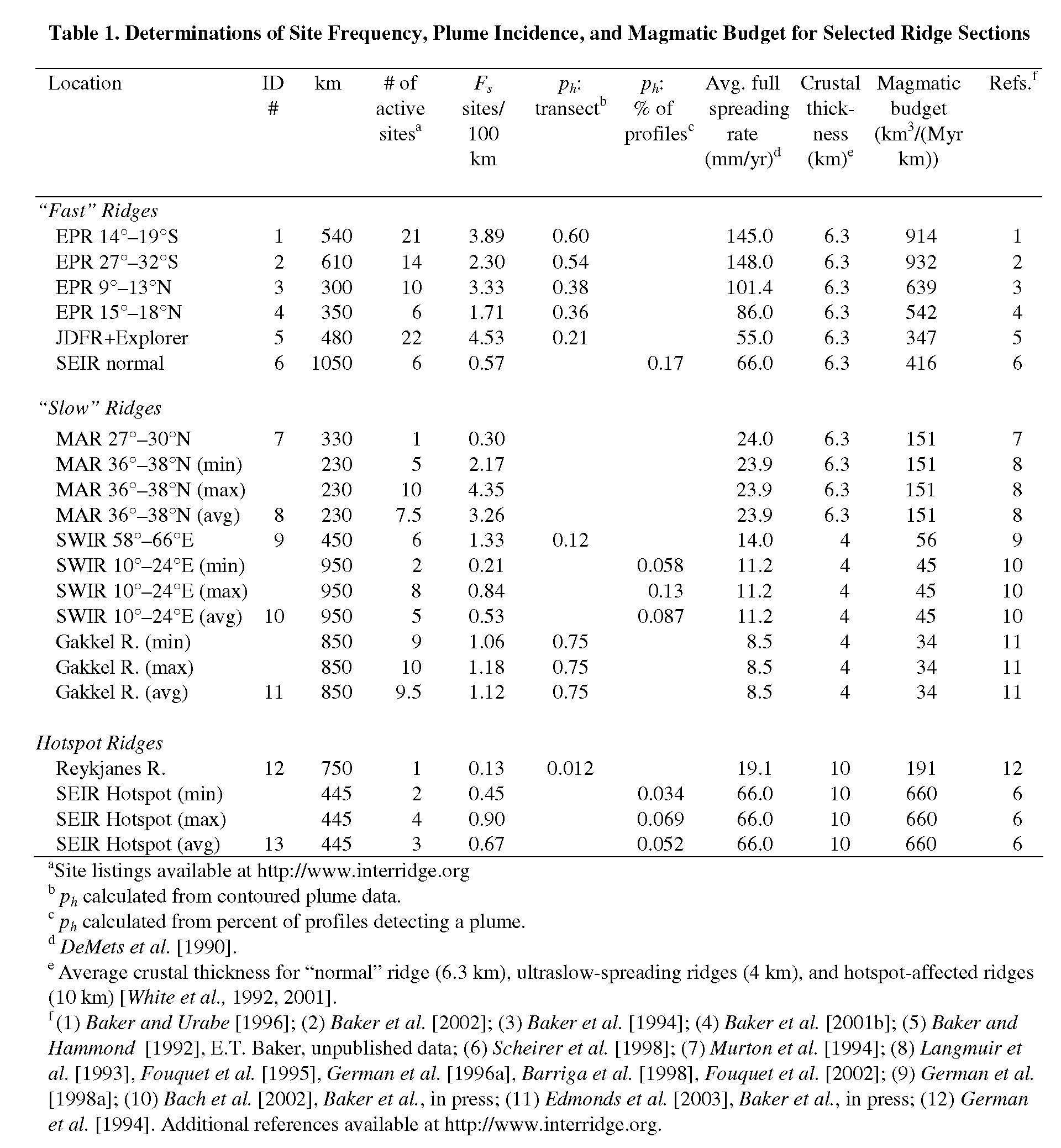
Table 1. Determination of Site Frequency, Plume Incidence, and Magmatic Budget for Selected Ridge Sections
Return to References or go to Abstract