U.S. Dept. of Commerce / NOAA / OAR / PMEL / Publications
Geological indexes of hydrothermal venting
Edward T. Baker
Pacific Marine Environmental Laboratory, NOAA, Seattle,
Washington
Journal of Geophysical Research, 101(B6),
13,741–13,753 (1996)
Not subject to U.S. copyright. Published in 1996 by the American
Geophysical Union.
Segment-Scale Correlations
Segment Characteristics
Structural discontinuities ranging from first-order (transform faults) to fourth-order
(slight devals and offsets) define tectonic segments that determine the pattern
and timing of ocean crust creation [Macdonald
et al., 1991]. First-order and second-order (large OSCs with offsets
of ~2 to 30 km) discontinuities typically correspond to petrologic boundaries
and thus are thought to represent distinct spreading cells. The identification
of third- and fourth-order discontinuities is more subjective, and tectonic
and petrologic segmentation do not always agree [Macdonald
et al., 1991; Sinton
et al., 1991]. Because of these ambiguities, most of the segment boundaries
used here are first- or second-order. Exceptions are a third-order deval identified
at 9°17 N [Macdonald
et al., 1992], four third-order offsets of >2 km between 16°30
and 18°37S [Lonsdale,
1989; Scheirer
et al., 1996], and fourth-order (?) devals at 15° and 17°05S.
All mark significant petrological boundaries [Langmuir
et al., 1986; Sinton
et al., 1991]. Detailed seafloor mapping can reveal hydrothermal, volcanic,
petrologic, and magmatic variations at the scale of fourth-order segments [e.g.,
Langmuir et al., 1986; Toomey
et al., 1990; Haymon
et al., 1991; Wright
et al., 1995], but these variations likely arise from local conditions
that require careful geologic mapping to document (e.g., the scale of individual
fissure eruptions). Such mapping is rare along most of these three study areas.
N [Macdonald
et al., 1992], four third-order offsets of >2 km between 16°30
and 18°37S [Lonsdale,
1989; Scheirer
et al., 1996], and fourth-order (?) devals at 15° and 17°05S.
All mark significant petrological boundaries [Langmuir
et al., 1986; Sinton
et al., 1991]. Detailed seafloor mapping can reveal hydrothermal, volcanic,
petrologic, and magmatic variations at the scale of fourth-order segments [e.g.,
Langmuir et al., 1986; Toomey
et al., 1990; Haymon
et al., 1991; Wright
et al., 1995], but these variations likely arise from local conditions
that require careful geologic mapping to document (e.g., the scale of individual
fissure eruptions). Such mapping is rare along most of these three study areas.
The three study areas thus include 14 segments: four of intermediate spreading
rate, three fast, and seven superfast. For each segment I determined ph
and the mean and standard deviation of Enet,
Axs, MgO wt%, and us. The percent of
each segment underlain by an AMC reflector was calculated only for the northern
and southern EPR. Layer 2A variations are not considered as a separate index
because data throughout the neovolcanic zone are available from only a few cross-axis
MCS lines. Correlations between geological indexes and ph
are expressed in a series of scatterplots (Figure
4).
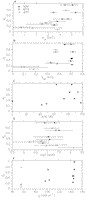
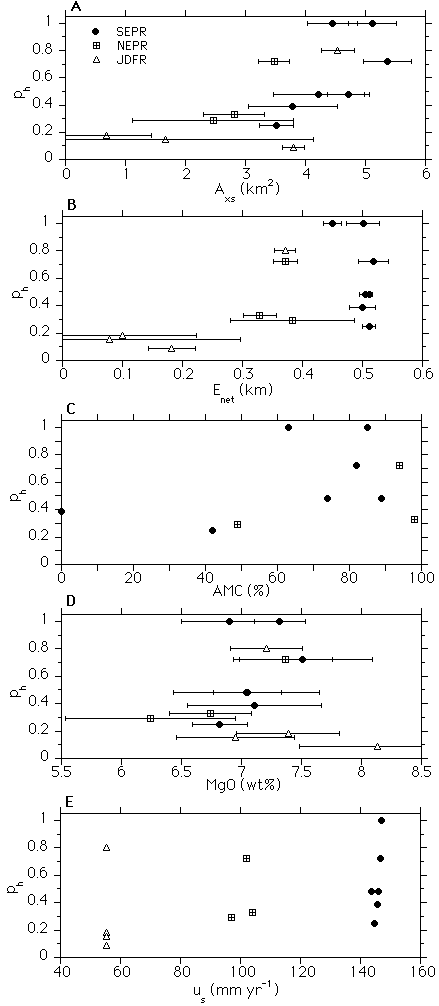
Figure 4. Scatterplots of the mean and standard deviation of (a) Axs,
(b) Enet, (c) AMC percent coverage, (d) MgO wt%, and (e)
us against plume incidence ph for each
of 14 segments. Standard deviations are not applicable for AMC and are negligible
for spreading rate.
Axs exhibits the strongest correlation with ph
(Figure 4a). An exponential least squares fit
of Axs versus ph gives an r2
value of 0.54, the only index with r2 > 0.5.
Enet (Figure 4b) displays
a similar trend but weaker correlation (r2 = 0.27).
(There is no correlation between ph and absolute depth of
the ridge axis.) Relationships between these measures of ridge inflation and
the magma supply rate are complex. Along-axis changes in ridge inflation are
evidently controlled both by factors directly related to magma supply (eruption
rates, melt lens inflation) and those more indirectly related (structural variations
in the low-velocity region within the crust) [Harding
et al., 1993; Scheirer
and Macdonald, 1993; Kent
et al., 1994]. The thickness of layer 2A at the axis is not related
to either Axs or Enet, as it is uniform
at ~200 m throughout fast and superfast spreading EPR study areas [Harding
et al., 1993; Christeson
et al., 1994; Kent
et al., 1994; Mutter
et al., 1995]. A thickness of 350400 m is common where measured
on the JDFR [Cudrak
and Clowes, 1993; McDonald
et al., 1994], but fine-scale variations are ±150 m. Differences
in the near-axis volume of layer 2A can be significant when Axs
varies by a factor of 2 (as between 9°40 and
13°30N [Harding
et al., 1993]) but can be relatively invariant for smaller Axs
changes (14° to 14°30S [Kent
et al., 1994]). Scheirer
and Macdonald [1993] have also suggested a temporal difference between
Axs and Enet. They note that while these
indexes are generally well correlated, axial lengths where Enet
is high relative to Axs may indicate segment portions
where the magma supply has only recently begun to increase, as along 14°3016°30S
(Figure 3c). At least in that area, however,
the proposed increase in magmatic activity causing an increase in Enet
has not produced an AMC reflector under most of the axis nor substantially enhanced
hydrothermal activity. An explanation of Axs and Enet
in terms of the magmatic budget will require more data on the three-dimensional
structure of the ridge axis than are presently available.
Whereas Axs and Enet are indirect indexes
of the magma supply rate, AMC percent coverage is a direct, though simplistic,
index of the relative availability of pooled magma to power hydrothermal activity.
Other AMC characteristics, such as depth and width, either show little intersegment
variation, large variations at the spatial scale of kilometers, or cannot yet
be calculated for most segments. Within the limited areas of the northern and
southern EPR where AMC width has been determined [Kent
et al., 1993a, b,
1994;
Mutter
et al., 1995], it shows no clear correlation with other geological
indexes. Careful analyses of along-axis MCS data on the EPR indicate that although
the depth of the AMC reflector decreases with increasing us
on a regional basis [Purdy
et al., 1992], there is little systematic along-axis variation within
a given area [Harding
et al., 1993; Detrick
et al., 1993; Kent
et al., 1993a, b].
Depth variations in the AMC originally thought to correlate with hydrothermal
activity on the 9°10°N segment of the EPR [Haymon
et al., 1991; Baker
et al., 1994] have since been shown to result mostly from a combination
of ship wander and the sharp increase in layer 2A thickness along the edges
of the neovolcanic zone [Kent
et al., 1993a, b].
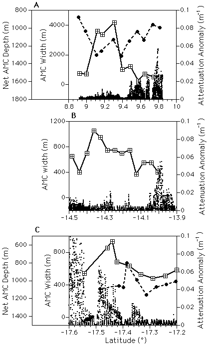
Figure 5 shows comparisons of AMC width and
depth with plume distributions where AMC data are available from the northern
and southern EPR [Kent
et al., 1993a, b;
Kent
et al., 1994; Mutter
et al., 1995]. No consistent relationships are apparent in any of the
three areas. AMC width is greatest near the 9°03N
OSC (Figure 5a), which Kent
et al. [1993b] attribute not to an increased magma supply rate but
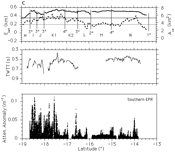
to decoupling between melt supply and the emplacement of extrusives on the seafloor.
Even at 17°25S on the southern EPR [Mutter
et al., 1995], where a broad and shallow AMC spike underlies a peak
in hydrothermal activity, more and greater hydrothermal maxima occur in adjacent
segments where the AMC depth varies little [Urabe
et al., 1995; Baker
and Urabe, 1996].
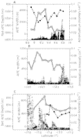
Figure 5. Detailed comparisons of plume distribution with AMC width
(solid line) and depth (dashed line) reveal no systematic correlation. AMC width
and depth from cross-axis seismic reflection lines along the (a) northern [Kent
et al., 1993a, b]
and (b,c) southern [Kent
et al., 1994; Mutter
et al., 1995] East Pacific Rise. Symbols on each line show location
of cross-axis lines; no depth information is yet available for the 14°14.5°S
section. "Net AMC depth" is depth to the AMC reflector less the thickness
of layer 2A. This calculation accounts for changes in apparent AMC depth caused
by ship wander and the rapid off-axis thickening of layer 2A.
There is a slight tendency for MgO wt% to increase with increasing ph
on the EPR, but the JDFR trend is nearly the opposite (Figure
4d). Petrologic variations along the JDFR are likely to be complicated by
the presence of a mantle thermal anomaly at the site of Axial Volcano [Rhodes
et al., 1990], propagating rifts at the southern end of Cleft and the
northern end of Cobb segments [Sinton
et al., 1983], and the lack of a steady state magma chamber along much
of the JDFR [Christeson
et al., 1993; Cudrak
and Clowes, 1993].
Finally, ph shows extreme variability for all values of
us (Figure 4e). The poor
predictive value of us on the scale of individual segments
is an expected consequence of its slight and uniform along-axis variation within
each study area.
Figure 4 makes it clear that no simple functional
relation exists between the distribution of hydrothermal venting on a particular
segment and any of the geological indexes examined. Nevertheless, it is also
apparent that plume incidence is not distributed randomly among the segments
studied. In every case, the probability of observing a higher ph
is greatest for high values of the geological indexes. Segments with Axs > ~3.5 km2,
Enet > ~0.35 km, AMC coverage > ~60%,
and (for the EPR) MgO > ~7 wt% have a much higher mean ph
than other segments. To produce a plot including all the indexes, I calculated
for each observation a normalized value x
= (x- )/
)/ x,
where x is the observed index value for a given segment, with
the mean value and x the
standard deviation of all 14 segments for a particular index. This normalization
produces a distribution with a mean of 0 and standard deviation of 1 for each
index. Spreading rate us is not included because it has
no significant segment-to-segment variation in a given study area. For the JDFR,
the normalization does not use AMC coverage percent because of a lack of data,
nor MgO wt% because of the complexities mentioned above.
x,
where x is the observed index value for a given segment, with
the mean value and x the
standard deviation of all 14 segments for a particular index. This normalization
produces a distribution with a mean of 0 and standard deviation of 1 for each
index. Spreading rate us is not included because it has
no significant segment-to-segment variation in a given study area. For the JDFR,
the normalization does not use AMC coverage percent because of a lack of data,
nor MgO wt% because of the complexities mentioned above.
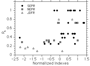
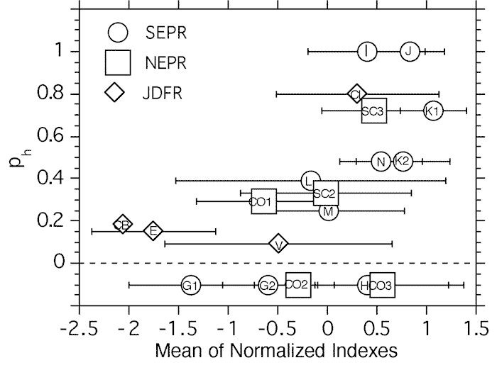
Plotting the normalized indexes of Axs, Enet,
MgO wt%, and AMC percent coverage against ph reveals that
the data fall into two distinct groups (Figure 6).
For normalized values  0.3 (slightly below
the mean value of each index), ph values never exceed 0.4
and have a mean value of 0.25 ± 0.09. For normalized values >0.3,
ph values range from 0.09 to 1 with a mean value of 0.63 ± 0.26.
This pattern indicates that segments do not support a vigorous hydrothermal
environment if their geological indexes indicate a relatively low recent magma
supply rate, regardless of the local long-term magma supply (i.e., us).
Conversely, segments with characteristics of a presently high magma supply rate
exhibit a range of hydrothermal activity from slight to ubiquitous. There is
little gradation between the two states in the available segment population.
Any segment whose geological indexes exceed the mean is a candidate for extensive
hydrothermal activity.
0.3 (slightly below
the mean value of each index), ph values never exceed 0.4
and have a mean value of 0.25 ± 0.09. For normalized values >0.3,
ph values range from 0.09 to 1 with a mean value of 0.63 ± 0.26.
This pattern indicates that segments do not support a vigorous hydrothermal
environment if their geological indexes indicate a relatively low recent magma
supply rate, regardless of the local long-term magma supply (i.e., us).
Conversely, segments with characteristics of a presently high magma supply rate
exhibit a range of hydrothermal activity from slight to ubiquitous. There is
little gradation between the two states in the available segment population.
Any segment whose geological indexes exceed the mean is a candidate for extensive
hydrothermal activity.
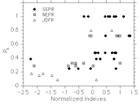
Figure 6. Scatterplot of normalized values of geological indexes (except
spreading rate) against plume incidence ph for each study
area. The distribution defines two populations: low ph when
the normalized index <0.3, and a highly variable ph
when the normalized index is >0.3. Each area has indexes in both populations.
Episodicity
The observations summarized in this paper suggest that the distribution of
ph shown in Figure 6 can
best be explained as a result of the episodic nature of magmatic and hydrothermal
processes at ridge crests. This hypothesis presupposes that hydrothermal fields,
at least on intermediate to superfast spreading ridges, typically begin, or
are renewed, as a sudden response to a dike injection. An injection instantly
invigorates hydrothermal circulation, producing widespread chronic venting and,
often, event plumes. This effect has been documented at the Cleft [Baker
et al., 1987; Embley
and Chadwick, 1994] and CoAxial [Embley
et al., 1995] segments of the JDFR and at 9°50N
on the EPR [Haymon
et al., 1993], and modeled by Lowell
and Germanovich [1994, 1995]
and Wilcock
[1994]. Still unpredictable is the timescale of the invigoration, which
might last from a few years to hundreds of years.
The model proposed here postulates that on magmatically starved segments (normalized
indexes <~0) episodes of dike intrusions are presently uncommon in both space
and time. Consequently, ph values are low and uniform. Segments
with a relatively high rate of magma supply (normalized indexes >~0) have
a greater probability of dike intrusions, leading to ph
values that are higher and more variable. Variability in ph
may arise both from between-segment differences in the magma supply that may
be steady on the order of 1 Myr, and from short-term (on the order of 1 kyr)
waxing and waning of the magma supply at a particular location. For example,
temporal stability in large-scale features such as ocean crustal thickness [Barth
and Mutter, 1996], abyssal hill characteristics [Goff,
1991], and lava petrology [Batiza
et al., 1996] suggests that the average magma supply rate at some locations
changes little over timescales of several hundred thousand years. Recent high-resolution
studies, however, provide evidence of high-frequency fluctuations not recorded
in these features. Careful mapping of along-axis volcanic, tectonic, and hydrothermal
patterns on the 9°1710°05N
segment clearly indicates that magma is episodically supplied, at intervals
of the order of 1 kyr, as individual intrusions on a fourth-order or smaller
spatial scale [Haymon
et al., 1991; Wright
et al., 1995]. Dense petrological sampling at several sites on the
northern EPR [Hekinian
et al., 1989; Reynolds
et al., 1992; Perfit
et al., 1994; Batiza
et al., 1996] has revealed a diversity of lava types that apparently
arises from rapid changes in the chemistry and temperature of magma lenses that
erupt at intervals of no more than 0.11 kyr.
Because of this interplay between low- and high-frequency magmatic fluctuations,
some segments (e.g., Cobb and CO1) have suffered a low mean magma supply rate
for perhaps several hundred thousand years. As a result, average index and ph
values are low even though small sections of these segments are hydrothermally
active at present. Other segments with high index values indicative of a high
mean magma supply rate have highly variable ph values, depending
on whether much (e.g., Cleft and J) or little (e.g., N and K2) of the segment
has been recently perturbed by dike intrusions. A presently high magma supply
rate is thus a necessary but not deterministic condition for large values of
ph.
Hydrothermal Predictions
The indexes described above, together with available data from the EPR, permit
some simple predictions about the likelihood of hydrothermal activity on segments
outside these study areas. Several segments adjacent to the northern and southern
EPR study areas have been examined for all five of the geological indexes discussed
here but as yet have no fine-scale continuous plume data. Segments CO2 and CO3,
bounded by OSCs at 11°45, 12°37,
and 12°54N, lie sequentially north of segment
CO1. Segments H, G2, and G1, bounded by OSCs at 18°37
and 19°, a deval at 19°24S, and a propagating
rift offset at 20°42S, lie sequentially south
of segment I. The degree of hydrothermal activity expected on each of these
segments should be predictable using the method described by Figure
6. Figure 7 shows a recalculation of the
normalized indexes, including these five additional segments. For each segment,
the various indexes have been averaged to give a mean value. The new segments
show a normalized index range of 1.3 to 0.4, indicating the possibility of
a wide range in ph. The model predicts a high probability
of extensive hydrothermal plumes along segments H and CO3, a moderate plume
distribution along G2 and CO2, and meager plumes over G1.
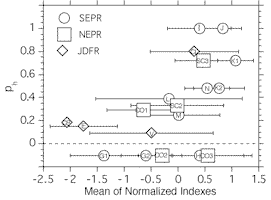
Figure 7. Scatterplot of the mean and standard deviation of normalized
values of geological indexes (except spreading rate) against plume incidence
ph for each studied segment plus five adjacent segments
where all four indexes can be calculated but no continuous plume distributions
are available. These segments are plotted below the ph = 0
line. Segment abbreviations are given in Figures 1 and 3.
Some information is available to test this prediction. Bougault
et al. [1990] mapped hydrothermal chemical anomalies along segments
CO2 and CO3 using their "dynamic hydrocast" system, which collected
an integrated plume sample approximately every 2 km between 12°10
and 13°10N. They covered CO3 completely and
observed significant Mn and CH4 anomalies along about three quarters
of the axis. CO2 was covered only partially and had somewhat less plume coverage.
Much of the rest of the EPR between 18°N and 23°S has been quantified in terms
of Enet and Axs by Scheirer
and Macdonald [1993], who used these data to predict the probability
of an AMC. Hey
et al. [1995] have recently produced similar data along five segments
surrounding a large overlap zone between the Easter and Juan Fernandez microplates.
I have averaged these data on a segment-by-segment basis [Lonsdale,
1989; Sinton
et al., 1991; Macdonald
et al., 1992; Hey
et al., 1995] to predict the distribution of hydrothermal activity
(Figure 8). Segments with Axs > 3.5
km2 and Enet > 0.35 km have a high
probability of present-day hydrothermal activity. On the northern EPR (Figure
8a) a short stretch of ridge just north of the Orozco transform fault is
a prime candidate. Also, most of the ridge between the Clipperton transform
fault and 6°N exceeds the threshold, but just barely. On the southern EPR (Figure
8b) a small region around the Gofar transform fault, the already discussed
13°19°S region, and the segments adjacent to the large overlap zone at 29°S
are the only locations with high values of both Enet and
Axs. Much of the ridge between Gofar and Garrett has Axs > 4 km2
but Enet between 0.2 and 0.3 km, so hydrothermal
explorations there will reveal much about the relative usefulness of Enet
and Axs as hydrothermal indexes.
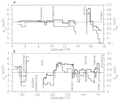
Figure 8. Segment-by-segment plot of cross-sectional area Axs
(dashed line) and net elevation Enet (solid line) for the
(a) northern and (b) southern EPR. The horizontal line in each panel marks the
3.5 km2 Axs and 0.35 km Enet
values, postulated as the approximate threshold for extensive hydrothermal activity.
Locations of transform faults and other major features are also given.
Return to previous section or go to next section
PMEL Outstanding Papers
PMEL Publications Search
PMEL Homepage