U.S. Dept. of Commerce / NOAA / OAR / PMEL / Publications
As Fornari and Embley [1995] point out in reviewing the tectonic and volcanic controls on submarine hydrothermal processes, the two principal factors are crustal permeability and magmatic heat. A systematic consideration of the effects of permeability is precluded by an almost complete lack of data on its magnitude and distribution in zero-age crust. Moreover, permeability is likely to be highly localized on a scale even smaller than the second- to third-order segments considered here [e.g., Wright et al., 1995]. In contrast, a variety of morphological, structural, and petrological indexes have been suggested as proxies for the along-axis variability of magmatic heat. These indexes are schematically summarized in Figure 2 and explained below.
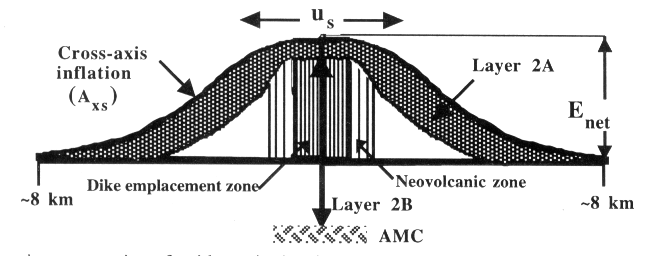
Figure 2. Schematic cross section of a ridge axis showing relationships between all of the geological indexes considered, except MgO wt% in axial basalts. See text for descriptions.
The height of the ridge axis above a reference depth (at 0.5 Ma) for each first-order segment is taken from Scheirer and Macdonald [1993] for the northern and southern EPR regions and calculated here for the JDFR using their method. Using Enet instead of absolute depth removes the effect of long-wavelength topographic variations not related to the recent magmatic budget at the axis. Enet equals the absolute ridge depth less the reference depths of 2994 and 2938 m for the northern EPR north and south, respectively, of the Clipperton transform fault, 3144 m for the southern EPR, and 2660 m for the JDFR.
Cross-sectional area of the ridge axis above the reference depth out to ±8 km from the spreading axis. Axs is effectively the average volume per unit length along the ridge. Scheirer and Macdonald [1993] calculated Axs at 1-km intervals along the EPR; I use a three-point boxcar-smoothed version of those data. JDFR Axs was calculated by the same method at ~6 km intervals, or at greater intervals where near-axis seamounts were present and would bias the profile.
Layer 2A is the seismic layer identified with volcanic extrusives in the near-axis region. The region between the ridge axis and the end of significant off-axis thickening of layer 2A is commonly defined as the neovolcanic zone [Harding et al., 1993; Christeson et al., 1994; Kent et al., 1994; McDonald et al., 1994].
An AMC reflector is a seismic reflection horizon interpreted as the top of a sill of partial melt lying immediately beneath the layer of sheeted dikes (layer 2B). The percentage of each segment underlain by an AMC reflector was determined from the along-axis data of Detrick et al. [1987, 1993], supplemented by cross-axis lines at the northern EPR [Kent et al., 1993a, b]. No JDFR segments have sufficient data to estimate this index.
The MgO wt% of magma melt varies directly with temperature [Helz and Thomber, 1987] and has been used as a relative index of the magmatic supply rate [e.g., Langmuir et al., 1986; Scheirer and Macdonald, 1993]. I used the instrumental correction factor given by Batiza and Niu [1992] to adjust the glass analyses of normal mid-ocean ridge basalts by various investigators using different analytical systems.
The spreading rate us is the full-rate separation at the spreading axis, corrected according to recent revisions of the geomagnetic reversal timescale [DeMets et al., 1994]. Corrected rates are approximately 96% of those calculated by the NUVEL-1 model of plate motion [DeMets et al., 1990] and earlier estimates [e.g., Elvers et al., 1973].
The distribution of hydrothermal activity along multisegment stretches of ridge axis is most efficiently ascertained by mapping the distribution of hydrothermal thermal, optical, and chemical anomalies in the overlying waters (see Baker et al. [1995] for a global summary). This paper uses optical (light attenuation), rather than thermal or chemical, anomalies to map the extent and location of hydrothermal sources. Many hydrothermal particles settle out of the plume soon after their formation above a vent field, so the optical signal defines discharge locations more precisely than the conservative thermal signal. Chemical data are generally not available in sufficient detail. The spatial density of plumes is quantified as plume incidence ph, the fraction of linear ridge axis overlain by a light attenuation anomaly exceeding the local background value of ~0.005 m1 (Figure 3). The determination of ph assumes that the effect of dispersal by along-axis currents has little effect on plume coverage. This assumption rests on the observation that in places with both detailed plume and seafloor observations, optical plume anomalies are co-located with discharge areas at a resolution scale of better than 10 km [Embley et al., 1991; Lupton et al., 1993; Baker et al., 1994, 1995; Baker and Urabe, 1996].
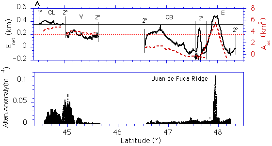
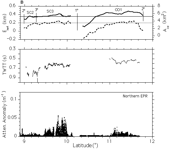
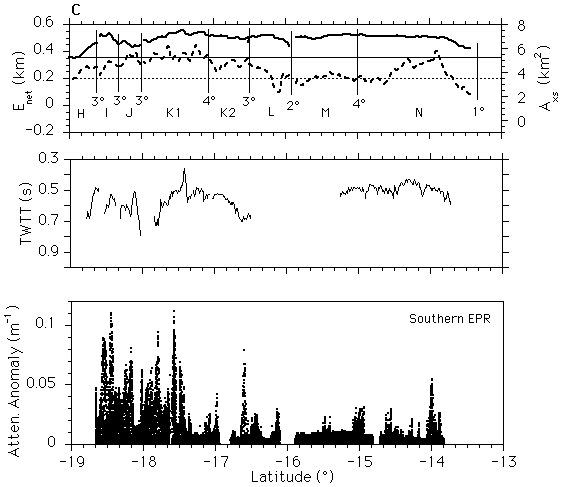
Figure 3. Comparison of (top) along-axis trends in Enet, or net elevation (heavy solid line), and Axs, or cross-sectional area (dotted line), of the ridge axis with (middle) the presence of an axial magma chamber reflector and (bottom) the distribution of hydrothermal plumes for (a) Juan de Fuca Ridge, (b) northern East Pacific Rise, and (c) southern EPR. The top panel for each area shows reference lines at a net elevation of 0.35 km (solid line) and an area of 3.5 km2 (dashed line), as well as position and order of segment boundaries used here. Data are from Scheirer and Macdonald [1993]. The middle panel (EPR only) shows depth to AMC in terms of two-way travel time (TWTT) between seafloor and the AMC [Detrick et al., 1987, 1993]. The true AMC distribution may be somewhat more extensive, as off-axis ship wander can cause reflector drop-outs [Kent et al., 1993a, b]. Plume distribution is revealed by continuous two-dimensional transects of light attenuation anomalies caused by suspended hydrothermal precipitates. Plume incidence is the fraction of ridge length overlain by plumes with light attenuation anomalies exceeding the background, generally ~0.0050.01 m1. Plume incidence increases from ~0.28 on the JDFR, to ~0.38 on the northern EPR, to ~0.6 on the southern EPR.
Return to previous section or go to next section