The widespread and systematic influence of ENSO on the ocean-atmosphere system led to initiation of the Tropical Ocean-Global Atmosphere (TOGA) Program, a 10-y study (1985-1994) of climate variability on seasonal to interannual time scales. Key to the success of TOGA is the accurate determination of basin scale fluctuations in surface winds, sea surface temperature (SST), upper ocean heat content, near-surface currents, and sea level in the tropical Pacific. Measurement of these oceanographic fields is required to describe fully the variability related to ENSO, to understand the physical processes responsible for that variability, and to initialize and verify short-term climate prediction models.
Plans for TOGA in the early 1980s called for an ocean observing system that would rely on an increased utilization of satellite products, in particular for SST, surface winds and sea level, and on the development of a "thin monitoring" array of in situ measurements based on an enhancement of existing capabilities. The in situ array would specifically include a volunteer observing ship (VOS) expendable bathythermograph (XBT) program, a tide gauge network, a drifting buoy program and about 15 moorings located principally in the eastern Pacific (U.S. TOGA Project Office, 1988). Unfortunately, even with the planned enhancement of existing in situ measurements, it was recognized that large areas of the tropical Pacific would still be poorly sampled and that important processes like wind-forced excitation and propagation of equatorial Kelvin waves would not be well resolved. The reliance on in situ measurements was further heightened by delays in satellite missions and/or temporal discontinuities in satellite data coverage. For example, launch of the U.S. National Aeronautics and Space Administration's scatterometer (NSCAT) for surface wind velocity estimates, originally scheduled for 1989, has been delayed until after the end of TOGA; and there was a 2-y hiatus in satellite sea level altimetry measurements between the end of the US Navy's GEOSAT (Geodetic Satellite) mission in 1989 and the launch of European Space Agency's Environmental Research Satellite (ERS-1) in 1991.
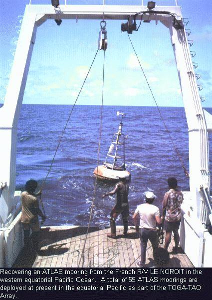
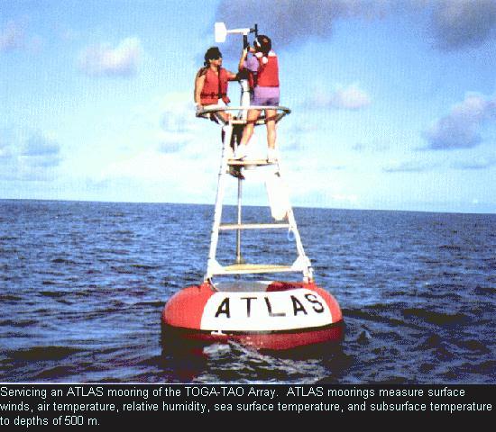
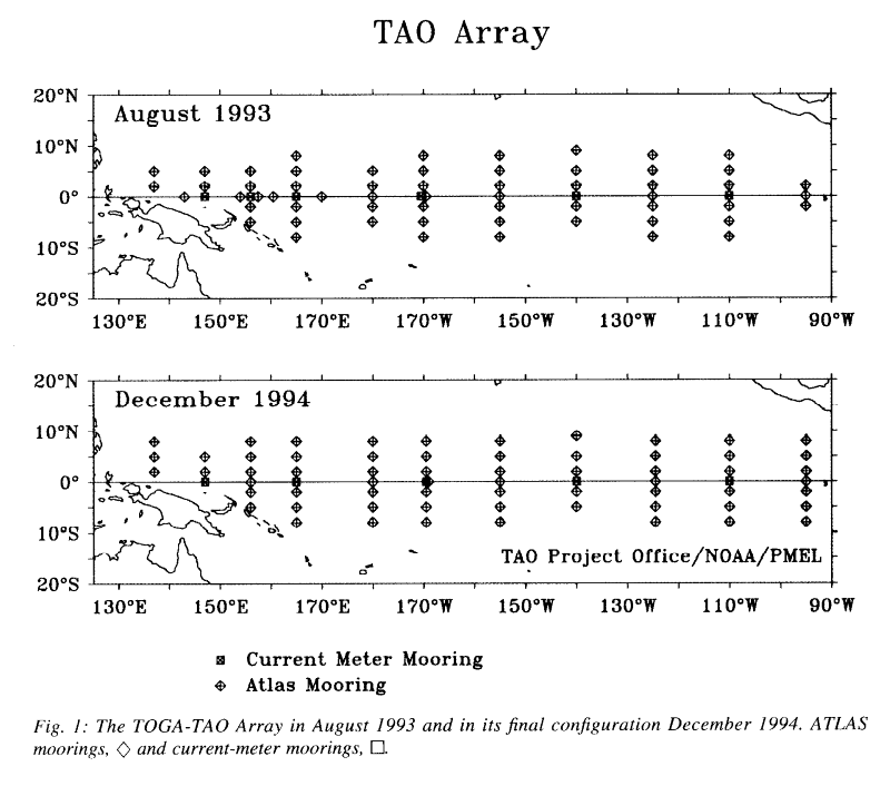
The need for improved in situ observational capabilities in TOGA motivated Dr. Stanley P. Hayes of the National Oceanic and Atmospheric Administration's Pacific Marine Environmental Laboratory (NOAA/PMEL) to develop a wind and thermistor-chain mooring capable of telemetering its data to shore in real-time. He also conceived and, until his untimely death in July 1992, directed the implementation of a basin-scale network of these moorings, which he called the TOGA Tropical Atmosphere Ocean (TAO) Array (Hayes et al., 1991b). TOGA-TAO far exceeded in scope what had been originally anticipated as a moored array component to the TOGA observing system. In April 1993, TAO consisted of 65 moorings; the array will expand to nearly 70 moorings by the end of 1994 (Fig. 1). Hayes also established a multi-national base of support for TOGA-TAO, which at present involves cooperation between the United States, France, Japan, Korea and Taiwan.
Go to PMEL Publications and Abstract page