UW PO Seminar Feb 1999
Warning: This writeup was done to help organize
my thoughts prior to the presentation.
The actual presentation may have been quite different!
Univ. Washington PO Seminar Feb 24, 1999
Presented at the lunchtime UW PO seminar (1 hour slot)
I. TITLE SLIDE. 2 min (2 min)
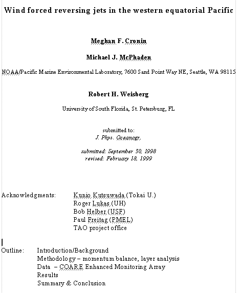
Wind Forced Reversing Jets in the Western Equatorial Pacific
Meghan Cronin
Michael McPhaden
NOAA Pacific Marine Environmental Laboratory
Robert Weisberg
University of South Florida, St. Petersburg, FL
submitted to JPO
Acknowledgements: Kunio Kutsuwada (Tokai U.), Roger Lukas (UH),
Robert Helber (USF), Paul Freitag, Dai McClurg, Dennis Moore, and
the TAO Project Office (PMEL).
Outline:
1) Introduction/background
2) Methodology -- momentum balance analyses
3) Data -- COARE Enhanced Monitoring Array
4) Results
5) Summary/Conclusion
This work I will be presenting today is described in a manuscript
which has been accepted for publication in JPO pending minor revision.
Before getting started, I would like to acknowledge my co-authors,
McPhaden and Bob Weisberg, Kunio Kutsuwada for providing ADCP data at
0 147E and 0 154E, Roger Lukas for providing SEACAT temperature and salinity
data at 0 154E and 0 160.5E, Bob Helber, Paul Freitag, Dai McClurg, Dennis
Moore and
the TAO project office.
The outline of the talk is straight forward: introduction/background,
methodolgy, data, results & summary/conclusion.
II. Hisard et al. 3 minute (5min)
One of the first observations of the complex current structure in the
western equatorial Pacific was provided by Hisard Merle and Voituriez
(1970). In March 1967, the R/V Coriolis lowered a current meter on a
wire to measure the current profiles as they did a hydrographic
section along the 170E meridian in the western equatorial Pacific.
This figure shows the zonal current structure and the temperature
cross section. Shading indicates westward flow (SEC), which on the
equator is about 70m deep. Below the SEC on the equator, we see the
EUC.
One month later, they returned and repeated the section. However,
instead of finding the SEC/EUC structure associated with steady trade
wind forcing, they found a reversing jet structure on the equator,
with eastward flow down to 60m, westward flow from 60-160m, and below
that the eastward flowing EUC.
In between cruises, there had been a WWB.
Clearly, the westerly winds caused the surface flow to accelerate
eastward and reverse directions. However, what caused the westward
accelerations at depth? This westward current is at a depth which had
previously been eastward flowing.
I use the term "reversing jet" broadly to mean currents which
reverse direction, both with respect to time, and with respect
to depth.
III. Background 3 minute (8min)
Since then, there has been alot of observations of the complex current
structure in the western equatorial Pacific. Each of these analyses
confirmed that the reversing jet structure was a response to WWB.
In general, though, these studies could measure the
current structure and one or two terms in the momentum balance.
For example, the Smyth et al. (1996) analysis had microstructure measurements
taken during COARE and showed that the shear on the upper and lower flanks
of the subsurface westward current was associated with substantial mixing.
There has also been alot of work done to understand the nature of the
WWB. WWB are a surface expression of the MJO. The superclusters of
convective clouds associated with the active phase of the MJO clearly
propagate eastward at 5-10 m/s. However, not all WWB translate.
There has also been a lot of analytical and numerical analyses done
to understand the equatorial ocean's response to wind forcing.
Cane & Sarachik, Moore & Philander, McCreary etc have shown that the
equatorial response to switched on winds includes a Yoshida Jet, and
a spectrum of equatorial waves propagating from the edges of the
wind patch.
A Yoshida Jet is an accelerating jet directly forced by the winds.
The details of the response, of course, depends upon the wind burst structure
(among other things). For example, a slowly eastward translating wind
patch will tend to generate eastward propagating KW, while a slowly
westward translating wind patch will tend to generate westward propagating
RW. Charlie Erikson has shown that a rapidly translating (c~ 10 m/s)
wind patch will tend to generate inertia gravity waves.
Finally, nearly all these analyses are linear. What happens in the real
ocean?
IV. COARE BASEMAP 1 minute (9min)
As a part of the COARE, for nearly 2 years from 1992 - 1994, there
was an enhanced monitoring array of TAO buoys and ADCPs shown here.
The array is centered at 0, 156E and can be considered a local dynamics
experiment in which nearly all terms in the momentum balance can be
evaluated. For example, at "Bob Weisberg's" diamond
array, vertical velocity could be computed from estimates of the
horizontal divergence. Thus we could estimate zonal, meridional and
vertical advection.
Surface met data including winds, air temperature and relative
humidity are shown by the top line. Note at the central site, 0,156E,
we also had a radiometer from September 1992 through April 1994. Using this
surface met data, we could compute the wind stress from the COARE v2.5b
bulk algorithm.
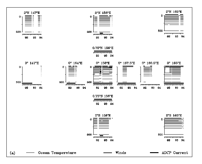
V. COARE EMA 1 minute (10min)
This slide shows the COARE EMA data availability map. These are the
sites along the equator, along 147E, 156E, and 165E. Sites with ADCPs
are shown by the thick line. Thin lines represents temperature between
1m and 500m. Notice that there are alot of data gaps, and some of the
records are shorter than others. For example, the subsurface
temperature data at 0 154E and 0 160.5E drop out during the second
half of 1993. At some sites, we also had salinity available although
it generally did not extend very deep.
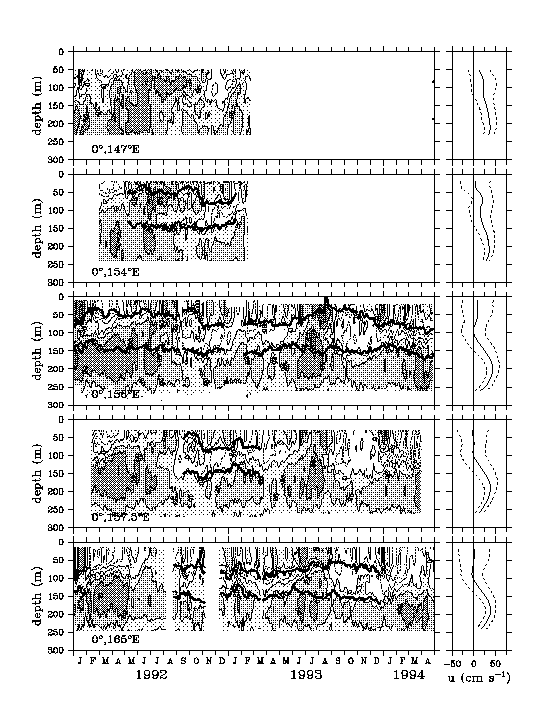
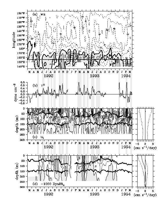
VI. U(x,z,t) 2 minute (12min)
This slide shows the zonal currents along the equator. Shaded contours
are eastward, dashes are westward. This is the EUC, the SEC. However, we
also see periods with all eastward flow throughout the upper 250m, and
periods with reversing jet structures. There is even this very strange
month in which the ADCPs show a 4 layer structure with westward, eastward,
westward, eastward flow. Often these thin jets are coherent over
thousands of kilometers.
The thick lines superimposed on the currents are the depth of the 28C
and 20C isotherm. The 28C isotherm is near the top of the thermocline.
Where it outcrops is considered the boundary of the warm pool. The 20C
isotherm is often used as a proxy for the "thermocline depth". Curiously,
these surfaces tend to be at the depths of the current reversals. Thus,
in my momentum balance analyses, I will define 3 layers: A surface layer
above the 28C isotherm, an intermediate layer between the 28C and 20C
isotherm, and the EUC layer below 20C.
The right panels show the mean profiles and standard deviation envelop.
Notice that the surface flow is highly variable. In comparison,
the EUC is relatively steady.
VII. v & w 1 minute (13min)
Just to be complete, here is the meridional and vertical velocity at
the central site, 0 156E. Notice that the meridional current oscillates
northward and southward with 15-day periodicity. Vertical velocity, which
was estimated from the divergence equation (conservation of mass), has
extended period of upwelling during the first year. Many of the events
are presumably due to Ekman upwelling and downwelling, however, in
general, there are many processes which can produce horizontal convergences
and divergences.
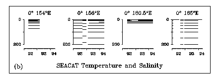
VIII. SEACAT T&S data availability 4 minute (17min)
To compute dynamic height, we need salinity.
This slide shows the SEACAT temperature and salinity data availability.
Note that salinity is available only down to 200 m at 0 156E and 0 165E,
and at 0 154E and 0 160.5E, there's data only down to 70m and 30m. As
I showed in the previous slide, at most sites, I have temperature data
down to 500m, which is well below the EUC. To compute dynamic height
relative to 500 db, I need to extrapolate salinity down to all the deeper
temperature sensors depths. There are two ways to do this. I can throw up
my hands and ignore the salinity data. In this case I can use a historical
TS curve to estimate salinity as a function of temperature. In general,
there will be quite a bit of scatter in the observed TS pairs about this
curve.
Or, I can blend the surface SEACAT data time series with CTD data to produce
a time varying TS curve for each location. I can then use the measured T
to get the appropriately varying salinity at each depth below the deepest
SEACAT sensor. SEACATs have T&S well sampled wrt time, but sparsely sampled
wrt depth. CTDs are sparsely sampled wrt time, but well sampled wrt depth.
To blend these disparate TS data, I use optimal interpolation scheme:
As a first step, I average all the TS curves on sigma surfaces which were
collected within a certain window (3 weeks x 4 degree longitude x 2 degree
latitude). Then I linearly interpolate the TS curves wrt time to get
the slowly time varying TS curve.
From this, I subtract the measured SEACAT TS pairs, and them map the
TS deviations onto a regular grid using a prescribed correlation function
-- a gaussian function wrt temperature and time. My correlation time scale
for the TS variabitity was 20 days. Because there is more scatter at the
surface then at depth, I use temperature dependent correlation scale for
temperature. Above 27C, SEACAT TS measurements can cause deviations in the
TS curve only over about a 1C range. In contrast, below 25C, the measurements
can cause TS curve deviations over about a 5C range.
Then given my observed time-varying TS curves at each site, I can use
the observed temperature below the deepest SEACAT to estimate salinity, and
dynamic height.
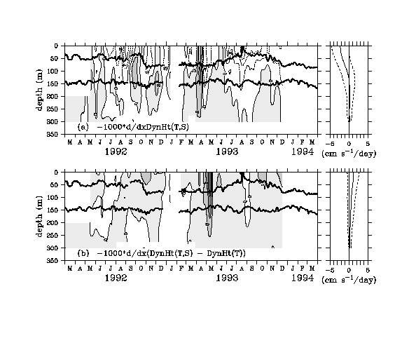
IX. -dPdx & error(-dPdx) 2 minute (19min)
Why all the fuss?
The upper panel shows the pressure gradient force due to the
dynamic height zonal gradient. The lower panel shows the difference
in this force when I estimate my dynamic using observed TS vs. using
the Levitus TS relationship to estimate salinity from temperature.
The CI is the same in both panels: 2 cm/s/day. Clearly, salinity variability
can induce substantial pressure gradient both at the surface and at depth.
X. wind, TAU, dudt, -dPdx 3 minute (22min)
Putting this all together...
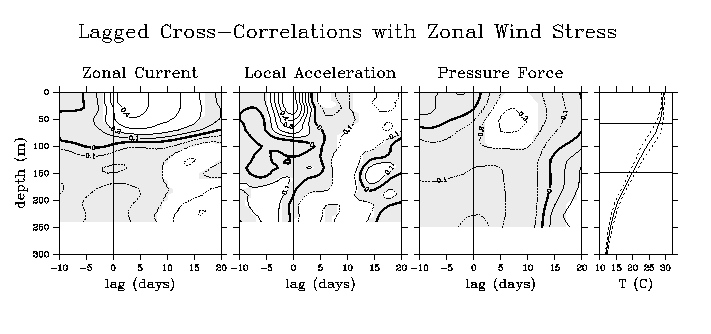
XI. RXY TAU vs. u, dudt, -dPdx 3 minute (25min)
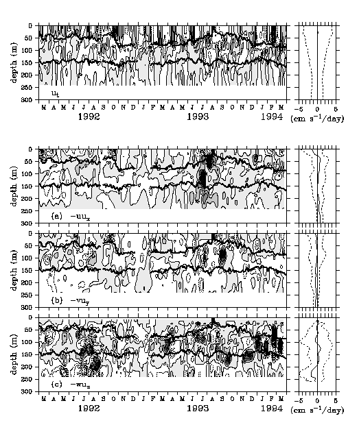
XII. dudt vs. nonlinear terms as function of depth 2 minute (27min)
Of course, this discussion so far has been about linear dynamics. Is the
ocean really linear though?
This figure shows the u_t, NL, and each advective term. CL are all the
same. Clearly, the ocean is very NL, due in large part to wdudz.
XIII. RXY TAU vs. -ududx, -vdudy, -wdudz 3 minute (30min)
Top panel shows Philander and Packanowski's model runs for a linear ocean
forced by steady trades, NL, and NL forced by westerlies. Notice that in
both NL cases, the eastward current on the equator is stronger. In
the case of easterly winds this is due to upwelling of the EUC. In the
case of westerlies, this is due to downwelling of the wind forced eastward
current.
This effect can be seen in the lagged correlations.
XIV. MOMENTUM EQUATION 1 minute (31min)
Finally, the residual. But first, lets just look at the momentum balance.
Breaking the stress divergence term into a body force applied to the
surface layer and a deviation from body force term, we can define
a residual which will be equal to the deviation from body force
stress divergence PLUS ERRORS!
Caution is warranted when trying to interpret the
residual in terms of physics.
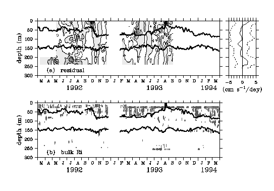
XV. resid function of depth 1minute (32min)
The bottom panel shows the low values bulk Ri number, which indicates
possible locations of mixing. Because there are low Ri values below
the surface layer, some of this residual in the INT and EUC layer may
be due to mixing.
XVI. rxy ut & mom 1 min (33 min)
Now I've talked about alot of processes associated with WWB. But what
is actually causing the flow to accelerate and reverse directions?
This slide shows the lagged cross correlation of dudt with each term
in the momentum balance. We see that All terms are correlated with dudt !
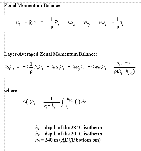
XVII. Layer momentum balance 1 min (34 min)
Obviously it's very complex. I've found that a helpful tool for seeing
how each process effected the current structure was to look at the
layered momentum balance. This is done by vertically averaging the momentum
balance in each layer with layer depths defined as the 28C, 20C, and 240 m.
XII. Surface layer balance 2 minute (36min)
XIII. Intermediate layer balance 2 minute (38min)
Look at that near balance between u_t and dPdx ! This near balance
is indicative of equatorial waves.
XIV. EUC layer balance 1 minute (39min)
NL terms are very important here.
XV. Summary 3 minute (42min)
In closing I'd like to say that the equator is a funny place -- the
Earth's axis of rotation is perpendicular to the vertical
axis. Consequently, there is no Coriolis turning and wind forcing can
lead to large local accelerations and strong currents. However, even
for sustained wind forcing, equatorial currents do not accelerate
indefinitely.
Becasue of the relatively fast equatorially trapped waves, the
equatorial ocean can adjust rapidly to wind forcing by setting up an
opposing pressure gradient. The resulting pressure gradient can
support a subsurface counterflow, as for example in the case of the
eastward EUC beneath the surface westward SEC for steday trade wind
forcing.
Return to Meghan Cronin'
s Home Page