Dear LAS mailing list,I'm wondering how subsetting curvilinear plots in LAS works. Particularly, if the LAS selection box exceeds the bounds of the regridded curvilinear domain, what formula does Ferret use to transform the "out of bounds" coordinates to the proper values for Ferret's internal use?
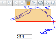
Attached are some screenshots to show an example. On [screen_1.png], I've done a rubberband selection on the mini-map with the lower-left portion being outside the dataset domain. On [screen_2.png], you can clearly see that the "out of bounds" area has been properly adjusted to be within the domain. Kindly take note that this is a curvilinear dataset.
In addition, if I make a rubberband selection, does Ferret regrid the entire domain first and then subset from there, or does LAS pass the selection lon/lat coordinates to Ferret and Ferret transforms the coordinates to the x/y equivalent in order to subset the curvilinear dataset before regridding? Any information is greatly appreciated.
--
Regards,
Anton Buenavista
Attachment:
screen_1.png
Description: PNG image
Attachment:
screen_2.png
Description: PNG image