Hi all,
I get an error message on the AVISO LAS (http://las.aviso.oceanobs.com), i don't understand why :
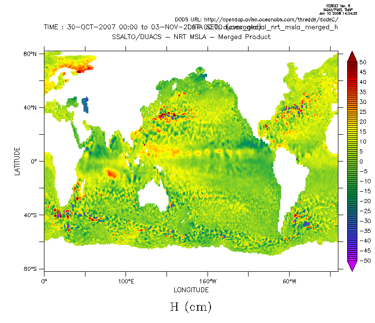
I try to compute the time average of the variable of the dataset
http://opendap.aviso.oceanobs.com/thredds/dodsC/duacs_global_nrt_msla_merged_h (Maps of Sea Levels Anomalies), a time average from
30-oct-2007 to 02-nov-2007, but I get the error below. If I try on the dates 15-oct-2007 to 27-oct-2007 it works...
When I try to do the same action with ferret manually (from 30-oct-2007 to 02-nov-2007), I have no error (see image attached).
Any help on this ?
Best regards,
Tony
PS : this is a LAS Armstrong 1.0
*** NOTE: Units on axis "LATLON" are not recognized: count
*** NOTE: They will not be convertible:
**ERROR: variable unknown or not in data set: GRID_0001_REGRID
DEFINE SYMBOL data_num = `grid_0001_regrid,return=dsetnum`
Command file, command group, or REPEAT execution aborted
STOP -script mode, ERROR RUNNING SCRIPT statement executed
go "$1"
!-> go "/home/avisonrt/las.armstrong.1.0/tomcat/webapps/las/WEB-INF/classes/resources/ferret/temp/ferret_operation_1199972029041.jnl"
! Symbols from the server
DEFINE SYMBOL data_0_ID = grid_0001
DEFINE SYMBOL data_0_dataset_ID = duacs_global_nrt_msla_merged_h
DEFINE SYMBOL data_0_dataset_name = global nrt msla h merged
DEFINE SYMBOL data_0_dataset_url = http://rdp2-jaune.cls.fr:8180/thredds/dodsC/duacs_global_nrt_msla_merged_h
DEFINE SYMBOL data_0_ftds_url = http://las.aviso.oceanobs.com/thredds/dodsC/las/duacs_global_nrt_msla_merged_h/data__rdp2-jaune.cls.fr_8180_thredds_dodsC_duacs_global_nrt_msla_merged_h.jnl
DEFINE SYMBOL data_0_grid_type = regular
DEFINE SYMBOL data_0_intervals = xyt
DEFINE SYMBOL data_0_name = Maps of Sea Level Anomalies Merged
DEFINE SYMBOL data_0_points = xyt
DEFINE SYMBOL data_0_region = region_0
DEFINE SYMBOL data_0_title = Maps of Sea Level Anomalies Merged_1 [ t= 30-Oct-2007 00:00:00 : 03-Nov-2007 00:00:00 @ave]
DEFINE SYMBOL data_0_units = cm
DEFINE SYMBOL data_0_url = http://las.aviso.oceanobs.com/thredds/dodsC/las/duacs_global_nrt_msla_merged_h/data__rdp2-jaune.cls.fr_8180_thredds_dodsC_duacs_global_nrt_msla_merged_h.jnl_expr_%7B%7D%7Blet+grid_0001_regrid%3Dgrid_0001%5Bd%3D1%2Ct%3D%2230-Oct-2007+00%3A00%3A00%22%3A%2203-Nov-2007+00%3A00%3A00%22%40ave%5D%7D
DEFINE SYMBOL data_0_var = grid_0001_regrid
DEFINE SYMBOL data_count = 1
DEFINE SYMBOL ferret_contour_levels = 5D
DEFINE SYMBOL ferret_fill_type = fill
DEFINE SYMBOL ferret_format = shade
DEFINE SYMBOL ferret_interpolate_data = false
DEFINE SYMBOL ferret_land_type = contour
DEFINE SYMBOL ferret_mark_grid = no
DEFINE SYMBOL ferret_palette = rnb2
DEFINE SYMBOL ferret_script_prefix = oer_
DEFINE SYMBOL ferret_service_action = Plot_2D_XY
DEFINE SYMBOL ferret_shade_type = shade
DEFINE SYMBOL ferret_size = 0.5
DEFINE SYMBOL ferret_timeout = 120
DEFINE SYMBOL ferret_view = xy
DEFINE SYMBOL las_debug = info
DEFINE SYMBOL operation_ID = Plot_2D_XY
DEFINE SYMBOL operation_key = A59CB3E33E6BF68A9823F067E0A207A8
DEFINE SYMBOL operation_name = Color plot
DEFINE SYMBOL operation_service = ferret
DEFINE SYMBOL operation_service_action = Plot_2D_XY
DEFINE SYMBOL product_server_0_ps_timeout = 3600
DEFINE SYMBOL product_server_0_ui_timeout = 20
DEFINE SYMBOL product_server_0_use_cache = true
DEFINE SYMBOL region_0_x_hi = 180
DEFINE SYMBOL region_0_x_lo = -180
DEFINE SYMBOL region_0_y_hi = 81.9746
DEFINE SYMBOL region_0_y_lo = -82
DEFINE SYMBOL result_cancel_ID = cancel
DEFINE SYMBOL result_cancel_filename = /home/avisonrt/las.armstrong.1.0/tomcat/webapps/las/output/A59CB3E33E6BF68A9823F067E0A207A8_cancel.txt
DEFINE SYMBOL result_cancel_type = cancel
DEFINE SYMBOL result_count = 7
DEFINE SYMBOL result_debug_ID = debug
DEFINE SYMBOL result_debug_filename = /home/avisonrt/las.armstrong.1.0/tomcat/webapps/las/output/A59CB3E33E6BF68A9823F067E0A207A8_debug.txt
DEFINE SYMBOL result_debug_type = debug
DEFINE SYMBOL result_map_scale_ID = map_scale
DEFINE SYMBOL result_map_scale_filename = /home/avisonrt/las.armstrong.1.0/tomcat/webapps/las/output/A59CB3E33E6BF68A9823F067E0A207A8_map_scale.xml
DEFINE SYMBOL result_map_scale_type = map_scale
DEFINE SYMBOL result_plot_image_ID = plot_image
DEFINE SYMBOL result_plot_image_filename = /home/avisonrt/las.armstrong.1.0/tomcat/webapps/las/output/A59CB3E33E6BF68A9823F067E0A207A8_plot_image.gif
DEFINE SYMBOL result_plot_image_type = image
DEFINE SYMBOL result_plot_postscript_ID = plot_postscript
DEFINE SYMBOL result_plot_postscript_filename = /home/avisonrt/las.armstrong.1.0/tomcat/webapps/las/output/A59CB3E33E6BF68A9823F067E0A207A8_plot_postscript.ps
DEFINE SYMBOL result_plot_postscript_type = ps
DEFINE SYMBOL result_ref_map_ID = ref_map
DEFINE SYMBOL result_ref_map_filename = /home/avisonrt/las.armstrong.1.0/tomcat/webapps/las/output/A59CB3E33E6BF68A9823F067E0A207A8_ref_map.gif
DEFINE SYMBOL result_ref_map_type = image
DEFINE SYMBOL result_rss_ID = rss
DEFINE SYMBOL result_rss_filename = /home/avisonrt/las.armstrong.1.0/tomcat/webapps/las/output/D89227DD2840E2EA870FE627749F0736_rss.rss
DEFINE SYMBOL result_rss_type = rss
GO ($operation_service_action)
!-> GO Plot_2D_XY
!!!!!!!!!!!!!!!!!!!!!!!!!!!!!!!!!!!!!!!!!!!!!!!!!!!!!!!!!!!!!!!!!!!!!!!!
!
! $Author: rhs $
!
! Plot_2d_XY.jnl decides which script to call to make a 2D plot.
! In the "old" LAS UI a 2D plot has for XY has different options and other
! UI characteristics than other 2D plots so it needs its own script.
!
IF ($ferret_view"|xy>1|*>0") THEN
!-> IF 1 THEN
!! Make a plot in XY...
go xy_plot_2D
!!!!!!!!!!!!!!!!!!!!!!!!!!!!!!!!!!!!!!!!!!!!!!!!!!!!!!!!!!!!!!!!!!!!!!!!
! $RCSfile: xy_plot_2D.jnl,v $
! $Revision: 1.12 $
!
! $Author: ansley $
! $Date: 2006/08/11 16:45:54 $
! 2006/07/19 Fix test of ($ferret_contour_levels"0|*>1")
! 3/7/2007: ACM. Put code to check that the region was not too small, resulting
! in degenerate plot into LAS_initialize_data.jnl rather than in the
! individual plot scripts.
! 3/29/2007 ACM Fix logic interpreting contents of ferret_interpolate_data
! 7/15/2007 ACM Add lines to remove labels when a degenerate 2D plot is made
! This happens when the region chosen is smaller than a grid cell.
! XY_plot.jnl creates an XY plot for use with the Back End Server
! code that sits behind a Live Access Server (LAS).
!
! NOTE: This code handles overlays but not differencing.
!
! TODO: We should support user choice of the 'base layer' variable.
! TODO: From the Ferret script writers' perspective it would be nice
! TODO: if this were handled in the UI so that ($data_0_...) always
! TODO: referred to the base layer.
! Set any Ferret modes
!
! NOTE: Should we support any of the following Ferrt modes?
! NOTE: ASCII_FONT, CALENDAR, DEPTH_LABEL, LABELS, LATIT_LABEL, LONG_LABEL
IF ($ferret_interpolate_data%0|false>0|true>1|1|0|*>1%) THEN SET MODE INTERPOLATE
!-> IF 0 THEN SET MODE INTERPOLATE
DEFINE SYMBOL fview = `UPCASE("($ferret_view)")`
!-> DEFINE SYMBOL fview = XY
! Define symbols associated with the regign and data and perform any
! initialization needed for this dataset.
!
! NOTE: Adding support for a 'base layer' variable would mean passing
! NOTE: some other argument. For now, though, we always use 'data_0'
! NOTE: for the base layer and region.
GO LAS_initialize_region 0
!!!!!!!!!!!!!!!!!!!!!!!!!!!!!!!!!!!!!!!!!!!!!!!!!!!!!!!!!!!!!!!!!!!!!!!!
! $RCSfile: LAS_initialize_region.jnl,v $
! $Revision: 1.1 $
!
! $Author: ansley $
! $Date: 2006/07/06 17:54:11 $
!
! The LAS_initialize_region.jnl script defines the following symbols
! based on the region associated with data_#:
!
! region_~_lo/hi -- lo and hi points on a given axis
! region_~_range -- numeric range on a given axis
! region_~ -- domain in 'lo:hi' notation
! region_full -- synonym for 'region_xyzt'
! Incoming argument determines which region to use
! The default number is 0, and the default region is region_0.
! If we are making only a map, then there are no data_ symbols
! defined, so data_0_region is not set, but we can define region
! as region_0.
DEFINE SYMBOL num ($1"0")
!-> DEFINE SYMBOL num 0
DEFINE SYMBOL region_name data_($num)_region
!-> DEFINE SYMBOL region_name data_0_region
DEFINE SYMBOL region ($($region_name)"region_0")
!-> DEFINE SYMBOL region region_0
! Cancel any previously set limits or region symbols
CANCEL SYMBOL limits_x
CANCEL SYMBOL limits_y
CANCEL SYMBOL limits_z
CANCEL SYMBOL limits_t
CANCEL SYMBOL region_x
CANCEL SYMBOL region_y
CANCEL SYMBOL region_z
CANCEL SYMBOL region_t
CANCEL SYMBOL region_xy
CANCEL SYMBOL region_xz
CANCEL SYMBOL region_xt
CANCEL SYMBOL region_yz
CANCEL SYMBOL region_yt
CANCEL SYMBOL region_zt
CANCEL SYMBOL region_xyz
CANCEL SYMBOL region_xyt
CANCEL SYMBOL region_xzt
CANCEL SYMBOL region_yzt
CANCEL SYMBOL region_xyzt
CANCEL SYMBOL region_full
! NOTE: Occasionally the LAS applet will send in a longitude or latitude
! NOTE: that looks like "24.400000000000002". Such long, numerically
! NOTE: irrelevant numbers can overflow Ferret's maximum symbol length.
! NOTE: Rounding longitudes and latitudes to the nearest .00001 seems
! NOTE: reasonable for all but the most detailed datasets.
! NOTE: 'region_x_m360' and 'region_x_p360' are used for those visualizations
! NOTE: where Ferret doesn't auomatically deal with the modulo nature of
! NOTE: longitude and allow the script writer to deal with this manually.
IF ($($region)_x_lo"0|*>1") THEN
!-> IF 1 THEN
DEFINE SYMBOL region_x_lo = `INT(100000 * ($($region)_x_lo)) / 100000`
!-> DEFINE SYMBOL region_x_lo = -180
DEFINE SYMBOL region_x_hi = `INT(100000 * ($($region)_x_hi)) / 100000`
!-> DEFINE SYMBOL region_x_hi = 180
DEFINE SYMBOL limits_x = ($region_x_lo):($region_x_hi)
!-> DEFINE SYMBOL limits_x = -180:180
DEFINE SYMBOL limits_x_m360 = `($region_x_lo)-360`:`($region_x_hi)-360`
!-> DEFINE SYMBOL limits_x_m360 = -540:-180
DEFINE SYMBOL limits_x_p360 = `($region_x_lo)+360`:`($region_x_hi)+360`
!-> DEFINE SYMBOL limits_x_p360 = 180:540
DEFINE SYMBOL region_x = X=($region_x_lo):($region_x_hi)
!-> DEFINE SYMBOL region_x = X=-180:180
DEFINE SYMBOL region_x_m360 X=`($region_x_lo)-360`:`($region_x_hi)-360`
!-> DEFINE SYMBOL region_x_m360 X=-540:-180
DEFINE SYMBOL region_x_p360 X=`($region_x_lo)+360`:`($region_x_hi)+360`
!-> DEFINE SYMBOL region_x_p360 X=180:540
IF `($region_x_hi) GE ($region_x_lo)` THEN
!-> IF 1 THEN
DEFINE SYMBOL region_x_range = `($region_x_hi) - ($region_x_lo)`
!-> DEFINE SYMBOL region_x_range = 360
ELSE
ENDIF
ENDIF
IF ($($region)_y_lo"0|*>1") THEN
!-> IF 1 THEN
DEFINE SYMBOL region_y_lo = `INT(1000 * ($($region)_y_lo)) / 1000`
!-> DEFINE SYMBOL region_y_lo = -82
DEFINE SYMBOL region_y_hi = `INT(1000 * ($($region)_y_hi)) / 1000`
!-> DEFINE SYMBOL region_y_hi = 81.974
DEFINE SYMBOL limits_y = ($region_y_lo):($region_y_hi)
!-> DEFINE SYMBOL limits_y = -82:81.974
DEFINE SYMBOL region_y = Y=($region_y_lo):($region_y_hi)
!-> DEFINE SYMBOL region_y = Y=-82:81.974
IF `($region_y_hi) GE ($region_y_lo)` THEN
!-> IF 1 THEN
DEFINE SYMBOL region_y_range = `($region_y_hi) - ($region_y_lo)`
!-> DEFINE SYMBOL region_y_range = 163.97
ELSE
ENDIF
ENDIF
IF ($($region)_z_lo"0|*>1") THEN
!-> IF 0 THEN
ENDIF
ENDIF
! NOTE: Normally we use 'DEFINE SYMBOL ~ = ...'
! NOTE: For the time axis we use 'DEFINE SYMBOL ~ ...' because the Ferret
! NOTE: parser complains about unmatched quotes if we do it the other way.
IF ($($region)_t_lo"0|*>1") THEN
!-> IF 0 THEN
ENDIF
! Now build up all possible multi-axis regions, being careful not to use
! commas when a region is missing
! region_xy
IF ($region_x"0|*>1") THEN
!-> IF 1 THEN
IF ($region_y"0|*>1") THEN
!-> IF 1 THEN
DEFINE SYMBOL region_xy = ($region_x),($region_y)
!-> DEFINE SYMBOL region_xy = X=-180:180,Y=-82:81.974
ELSE
ENDIF
ELSE
ENDIF
ENDIF
! region_xz
IF ($region_x"0|*>1") THEN
!-> IF 1 THEN
IF ($region_z"0|*>1") THEN
!-> IF 0 THEN
ELSE
DEFINE SYMBOL region_xz = ($region_x)
!-> DEFINE SYMBOL region_xz = X=-180:180
ENDIF
ELSE
ENDIF
ENDIF
! region_xt
IF ($region_x"0|*>1") THEN
!-> IF 1 THEN
IF ($region_t"0|*>1") THEN
!-> IF 0 THEN
ELSE
DEFINE SYMBOL region_xt = ($region_x)
!-> DEFINE SYMBOL region_xt = X=-180:180
ENDIF
ELSE
ENDIF
ENDIF
! region_yz
IF ($region_y"0|*>1") THEN
!-> IF 1 THEN
IF ($region_z"0|*>1") THEN
!-> IF 0 THEN
ELSE
DEFINE SYMBOL region_yz = ($region_y)
!-> DEFINE SYMBOL region_yz = Y=-82:81.974
ENDIF
ELSE
ENDIF
ENDIF
! region_yt
IF ($region_y"0|*>1") THEN
!-> IF 1 THEN
IF ($region_t"0|*>1") THEN
!-> IF 0 THEN
ELSE
DEFINE SYMBOL region_yt = ($region_y)
!-> DEFINE SYMBOL region_yt = Y=-82:81.974
ENDIF
ELSE
ENDIF
ENDIF
! region_zt
IF ($region_z"0|*>1") THEN
!-> IF 0 THEN
ENDIF
ELSE
IF ($region_t"0|*>1") THEN
!-> IF 0 THEN
ENDIF
ENDIF
! region_xyz
IF ($region_xy"0|*>1") THEN
!-> IF 1 THEN
IF ($region_z"0|*>1") THEN
!-> IF 0 THEN
ELSE
DEFINE SYMBOL region_xyz = ($region_xy)
!-> DEFINE SYMBOL region_xyz = X=-180:180,Y=-82:81.974
ENDIF
ELSE
ENDIF
ENDIF
! region_xyt
IF ($region_xy"0|*>1") THEN
!-> IF 1 THEN
IF ($region_t"0|*>1") THEN
!-> IF 0 THEN
ELSE
DEFINE SYMBOL region_xyt = ($region_xy)
!-> DEFINE SYMBOL region_xyt = X=-180:180,Y=-82:81.974
ENDIF
ELSE
ENDIF
ENDIF
! region_yzt
IF ($region_yz"0|*>1") THEN
!-> IF 1 THEN
IF ($region_t"0|*>1") THEN
!-> IF 0 THEN
ELSE
DEFINE SYMBOL region_yzt = ($region_yz)
!-> DEFINE SYMBOL region_yzt = Y=-82:81.974
ENDIF
ELSE
ENDIF
ENDIF
! region_xyzt
IF ($region_xyz"0|*>1") THEN
!-> IF 1 THEN
IF ($region_t"0|*>1") THEN
!-> IF 0 THEN
ELSE
DEFINE SYMBOL region_xyzt = ($region_xyz)
!-> DEFINE SYMBOL region_xyzt = X=-180:180,Y=-82:81.974
ENDIF
ELSE
ENDIF
ENDIF
DEFINE SYMBOL region_full = ($region_xyzt)
!-> DEFINE SYMBOL region_full = X=-180:180,Y=-82:81.974
! If no regions have been defined then we have an error.
IF ($region_full"1|*>0") THEN
!-> IF 0 THEN
ENDIF
! End of LAS_initialize_region.jnl ------------------------------------------------------
GO LAS_initialize_data 0
!!!!!!!!!!!!!!!!!!!!!!!!!!!!!!!!!!!!!!!!!!!!!!!!!!!!!!!!!!!!!!!!!!!!!!!!
! $RCSfile: LAS_initialize_data.jnl,v $
! $Revision: 1.2 $
!
! $Author: ansley $
! $Date: 2007/29/2007
!
! The LAS_initialize_data.jnl script takes care of everything having to
! do with initializing a datset for later use.
!
! LAS_initialize_data.jnl takes an argument that specifies which data
! item [0|1|2|3|...] to create symbols for.
!
! 3/2007:
! split up previous version of LAS_initialize_data.jnl into two;
! initialize the dataset and define the plot (or output listing) variable.
! This allows the custom init scripts to call LAS_initialize_dataset, then
! issue commands for the customization, then call LAS_initialize_variable
!
! 8/2007:
! The custom init scripts now consist of only SET DATA and the custom commands.
! This lets F-TDS run first and call the init script to create the data set
! that will be used by the Ferret product script. When F-TDS is done it will
! not send the symbol ferret_init_script to the product scripts so we will just skip
! that step.
!
! 8/2007:
! Some of the custom init scripts previously contained commands like SET MEMORY
! or SET MODE which are intended to be executed by the product script These need
! to be separated from commands for fixing grids or regridding which are executed
! prior to the product script being run by F-TDS. These commands are to be specified
! in the dataset configuration as ferret_init_commands, whose the value is a set
! of Ferret commands separated by semicolons.
!
GO LAS_initialize_dataset ($1"0")
!-> GO LAS_initialize_dataset 0
!!!!!!!!!!!!!!!!!!!!!!!!!!!!!!!!!!!!!!!!!!!!!!!!!!!!!!!!!!!!!!!!!!!!!!!!
! $RCSfile: LAS_initialize_dataset.jnl
! This is the first part of LAS_initialize_data.jnl used for standard and
! customized init scripts
! $Author: ansley, jing
! $Date: 2007/29/2007
! 6/29/2007
! Allow for data_0_units or data_1_units etc to be defined a null string or a
! string containing a single space. If data_0_units is either undefined or is
! one of these blank strings, then use the attnames syntax to see if the dataset
! variable has units defined, and if so define the data_units symbol from that.
! The LAS_initialize_data.jnl script takes care of everything having to
! do with initializing a datset for later use.
!
! LAS_initialize_data.jnl takes an argument that specifies which data
! item [0|1|2|3|...] to create symbols for.
!ACM_note: if we use a loop in the plot routine, we are not
! limited to 9 data items
! DEFINE SYMBOL num ($1"0|0|1|2|3|4|5|6|7|8|9")
DEFINE SYMBOL num ($1"0")
!-> DEFINE SYMBOL num 0
! TODO: It would be nice if the java code removed this dependency upon
! TODO: whether an operation was 'chained' or not.
! Check whether the source data was part of a 'chained' operation.
!ACM note: How does this jibe with what I do below changing data_url to data_num??
IF ($data_($num)_chained"0|1|*>1) THEN
!-> IF 0 THEN
ELSE
DEFINE SYMBOL data_url \"($data_($num)_url)\"
!-> DEFINE SYMBOL data_url \"http://las.aviso.oceanobs.com/thredds/dodsC/las/duacs_global_nrt_msla_merged_h/data__rdp2-jaune.cls.fr_8180_thredds_dodsC_duacs_global_nrt_msla_merged_h.jnl_expr_%7B%7D%7Blet+grid_0001_regrid%3Dgrid_0001%5Bd%3D1%2Ct%3D%2230-Oct-2007+00%3A00%3A00%22%3A%2203-Nov-2007+00%3A00%3A00%22%40ave%5D%7D\"
ENDIF
IF ($data_($num)_var"0|*>1") THEN DEFINE SYMBOL data_var ($data_($num)_var)
!-> IF 1 THEN DEFINE SYMBOL data_var grid_0001_regrid
!-> DEFINE SYMBOL data_var grid_0001_regrid
IF ($data_($num)_units"0|*>1") THEN DEFINE SYMBOL data_units (($data_($num)_units))
!-> IF 1 THEN DEFINE SYMBOL data_units (cm)
!-> DEFINE SYMBOL data_units (cm)
! Do not define data_units with an empty string
IF ($data_($num)_units%1|"">1|*>0%) THEN CANCEL SYMBOL data_units
!-> IF 0 THEN CANCEL SYMBOL data_units
IF ($data_($num)_units%1|" ">1|*>0%) THEN CANCEL SYMBOL data_units
!-> IF 0 THEN CANCEL SYMBOL data_units
IF ($data_($num)_name"0|1|*>1) THEN
!-> IF 1 THEN
IF ($data_($num)_title"0|*>1") THEN DEFINE SYMBOL data_title ($data_($num)_title)
!-> IF 1 THEN DEFINE SYMBOL data_title Maps of Sea Level Anomalies Merged_1 [ t= 30-Oct-2007 00:00:00 : 03-Nov-2007 00:00:00 @ave]
!-> DEFINE SYMBOL data_title Maps of Sea Level Anomalies Merged_1 [ t= 30-Oct-2007 00:00:00 : 03-Nov-2007 00:00:00 @ave]
ELSE
ENDIF
DEFINE SYMBOL ferret_plot_title "($data_title) ($data_units)"
!-> DEFINE SYMBOL ferret_plot_title "Maps of Sea Level Anomalies Merged_1 [ t= 30-Oct-2007 00:00:00 : 03-Nov-2007 00:00:00 @ave] (cm)"
! TODO: Use new error features in Ferret to turn off STDERR and check
! TODO: for Ferret error symbols to see if the SET DATA command actually worked.
! SET DATA and check for errors
SET DATA ($data_url)
!-> SET DATA "http://las.aviso.oceanobs.com/thredds/dodsC/las/duacs_global_nrt_msla_merged_h/data__rdp2-jaune.cls.fr_8180_thredds_dodsC_duacs_global_nrt_msla_merged_h.jnl_expr_%7B%7D%7Blet+grid_0001_regrid%3Dgrid_0001%5Bd%3D1%2Ct%3D%2230-Oct-2007+00%3A00%3A00%22%3A%2203-Nov-2007+00%3A00%3A00%22%40ave%5D%7D"
IF ($fer_last_error"0|*>1") THEN
!-> IF 0 THEN
ENDIF
DEFINE SYMBOL data_num = `($data_var),return=dsetnum`
-- Tony JOLIBOIS CLS Space oceanography Division Product Information and Diffusion 8-10 rue Hermes, 31526 Ramonville-St-Agne, Cedex, France Email: tjolibois@xxxxxx Tel: (+33) (0) 561 393 797 http://www.cls.fr http://www.mercator-ocean.fr |
Attachment:
averaged_msla.gif
Description: GIF image