Well, Ferret v581 is quite old, and is no longer supported. The scripts run correctly with the
current v6.7 release. All I can assume is that this has been fixed in a more recent release.
Since you are running on a linux machine and we have up-to-date Ferret releases for your operating
system, my best recommendation is that you update your Ferret installation.
Ansley
On 6/16/2011 5:21 PM, Sergei Maurits wrote:
Ansley,
I run your script with some minor modifications (minor case sensitivity problems,level=v syntax in command fill) and got three picture in GIF
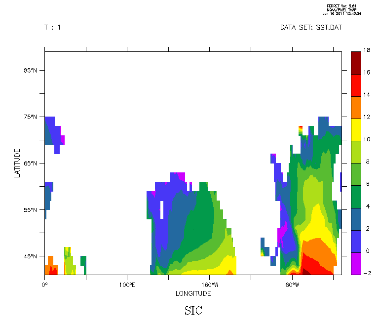
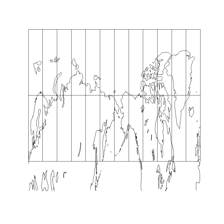
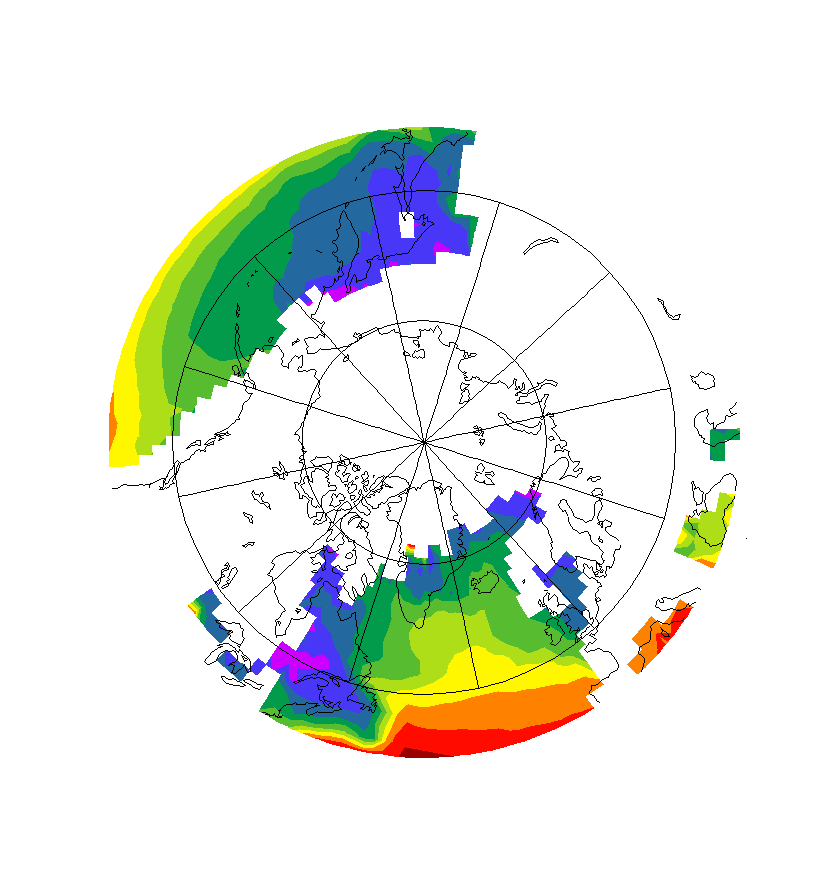
1. data fill in rectangular frame (data input proof) - OK, I see data2. data (rather absence of ...) fill in Plate Caree - only map and mesh, no data3. data fill in Stereographic - OK - data, map, and mesh
Basically, this is repetition of my previous findings, and because of that I did not modifiemy script moving data reading before the projection definition. I expect the same results.
Provided, you got #2 successfully using this below script, please let me know what is yourplatform and the Ferret verson?
I run Luniux RH and Ferret v. 5.81
I appreciate your attention to this question and time you spent addressing it. If you'd like,I can send to you my data (rather small) and custom color palette for experimenting.
Sergei Maurits
The script ( I run it in >ferret -gif mode)**********************************************************
SET MODE METAFILE ! output to metafile, PS-compatibleSET MODE VERIFY ! show command file lines at the screen
!Preparation, cleaning from last settingsCANCEL REGIONCANCEL VARIABLES/ALLCANCEL DATA/ALLCANCEL VIEWPORTS
! 6/16/2011Set up the dataset!definition of axis (x,y,t) and 3D grid from these axis
! CREATE A DATASET IN A SIMILAR FORMATUSE coads_climatologySET REGION/X=0:360/Y=40:90/L=1:12! error LIST/CLOBBER/NOHEAD/NOROW/FORM=(E12.5)/FILE=SST.DAT SSTLIST/CLOBBER/NOHEAD/FORM=(E12.5)/FILE=SST.DAT SSTCANCEL DATA/ALL
! Now define a grid and set up to read the datadefine axis/x=0.0e:359.0e:2/unit=degree ocnxdefine axis/y=41n:90n:2/unit=degree ocnydefine axis/t=1:12:1 ocntdefine grid/x=ocnx/y=ocny/t=ocnt ocngrid
!show grid ocngrid !optional
!DATA reading from formatted ASCII file into variable sicfile/format=(E12.5)/order=xyt/var=sic/grid=ocngrid SST.DAT !formatted file
show variable sic !optional
!introduction of variable sic_n = 100*sic if sic is > 0 or NoN otherwise
let sic_n = if sic gt 0.0 then sic*100 else (-1)^0.5!show variable sic_n ! optional
!!! JUST USE SIC_N = SIC!!! MAKE A TEST PLOT.LET SIC_N = SICFILL/L=1 SICframe/file="First_fill_data_proof.gif"PAUSE
!Setting region 40-90N, 0-360 , 12 monthsset region/l=1:12set region/x=0.0:360.0/y=40.0N:90.0N!SHOW REGION !optional
!Set window size and aspect ratio (will be overwritten if go mp_aspect is called)!SET WINDOW/SIZE=1.1/ASPECT=0.4 !(aspect up increases vert size, for Plate Caree)SET WINDOW/SIZE=1.1/ASPECT=1 !(aspect up increases vert size, 1 for stereographic)
!Show WINDOW size in pixselsshow symbol ppl$xpixelshow symbol ppl$ypixel!! Stereographic projection!===========================! Usage: arg1 arg2! go mp_stereographic_north [central meridian] [standard parallel]!! arg 1 - longitude used for the center of the projection! arg 2 - latitude used for the center of the projection
! go mp_stereographic_north -42.5 !stereographic projection
! NOTE: Do not forget to uncomment! go mp_aspect! below, if Stereographic projection is used
!!Simple Cylindrical or Plate Ceree projection for G.Earth!=========================================================! Usage: arg1 arg2! go mp_plate_caree [central meridian] [standard parallel]!! arg 1 - longitude used for the center of the projection! arg 2 - latitude used for the center of the projection
go mp_plate_caree -42.5 !Simple Cylindrical or Plate Caree projection for G.Earth
!show variables !optional!Comment the next line out for Simple Cylindrical or Plate Caree projection!go mp_aspect ! computes appropriate aspect, ovewritting SET WINDOW,! useful for stereographic projection, but SET WINDOW is better for P.C.
!Setting grid for variable sic_n, importantset grid sic_n!show grid sic_n !optional
! error (V) fill/nolab/noaxis/set_up/nokey/levels=v/L=1 sic_n*mp_mask,x_page,y_pagefill/nolab/noaxis/set_up/nokey/L=1 sic_n*mp_mask,x_page,y_page
ppl fill
!Optional contouring with different colors/line width!contour/over/noaxis/set_up/nolabels/color=4/levels=(15,90,15)/L=1 sic_n*mp_mask,x_page,y_page!ppl contour/over !ppl plot layout!contour/over/noaxis/set_up/nolabels/color=17/levels=(15,15,15)/L=1 sic_n*mp_mask,x_page,y_page!ppl contour/over !ppl plot layout!Adding map and geographic meshgo mp_graticule 0 360 30 50 90 20 1go mp_land 1 overlay! Output to GIF-fileframe/file="Second_fill_mp_Plate_Caree_proof.gif"
!! Stereographic projection!===========================! Usage: arg1 arg2! go mp_stereographic_north [central meridian] [standard parallel]!! arg 1 - longitude used for the center of the projection! arg 2 - latitude used for the center of the projection
go mp_stereographic_north -42.5 !stereographic projection
! NOTE: Do not forget to uncomment! go mp_aspect! below, if Stereographic projection is used
!!Simple Cylindrical or Plate Ceree projection for G.Earth!=========================================================! Usage: arg1 arg2! go mp_plate_caree [central meridian] [standard parallel]!! arg 1 - longitude used for the center of the projection! arg 2 - latitude used for the center of the projection
!go mp_plate_caree -42.5 !Simple Cylindrical or Plate Caree projection for G.Earth
!show variables !optional
!Comment the next line out for Simple Cylindrical or Plate Caree projectiongo mp_aspect ! computes appropriate aspect, ovewritting SET WINDOW,! useful for stereographic projection, but SET WINDOW is better for P.C.
!Setting grid for variable sic_n, importantset grid sic_n!show grid sic_n !optional
! error (V) fill/nolab/noaxis/set_up/nokey/levels=v/L=1 sic_n*mp_mask,x_page,y_pagefill/nolab/noaxis/set_up/nokey/L=1 sic_n*mp_mask,x_page,y_page
ppl fill
!Optional contouring with different colors/line width!contour/over/noaxis/set_up/nolabels/color=4/levels=(15,90,15)/L=1 sic_n*mp_mask,x_page,y_page!ppl contour/over !ppl plot layout!contour/over/noaxis/set_up/nolabels/color=17/levels=(15,15,15)/L=1 sic_n*mp_mask,x_page,y_page!ppl contour/over !ppl plot layout!Adding map and geographic meshgo mp_graticule 0 360 30 50 90 20 1go mp_land 1 overlay! Output to GIF-fileframe/file="Third_fill_mp_Stereographic_proof.gif"
CANCEL MODE METAFILE
********************************************************************************
Dr. Sergei Maurits, HPC SpecialistArctic Region Supercomputing Center
University of Alaska Fairbanks
Fairbanks, AK 99775-6020907 450 8697 voice 907 450 8604 fax.
maurits@xxxxxxxx
On Jun 16, 2011, at 8:43 AM, Ansley Manke wrote:
Hi -
Let's see if we can work this out and then report back to the users list when we know what's happening. I don't have your data of course but I wonder if the problem is in in reading the data or in the region settings.
I would move the setup of your input data, defining its grid, to the start of the script, to separate that from the map projection and plotting calls.
I made an example dataset from coads_climatology which is an XYT dataset, and read it in with similar commands to the ones you used. I used your same calls to set the region and define the map projection. I changed the levels and palette that you used, and the script runs correctly and makes a plot. So, first, I know that you have done this but make sure you can plot the data without the map projection. I did that in the script below, with a pause statement after it.
Here is my example script, see if you can run it and if you can spot what may be different in your example. I put the commands that I added for testing in all capital letters, marked with comments that start with !!!
****************************************************
SET MODE METAFILE ! output to metafile, PS-compatible
SET MODE VERIFY ! show command file lines at the screen
!Preparation, cleaning from last settings
CANCEL REGION
CANCEL VARIABLES/ALL
CANCEL DATA/ALL
CANCEL VIEWPORTS
! 6/16/2011Set up the dataset
!definition of axis (x,y,t) and 3D grid from these axis
! CREATE A DATASET IN A SIMILAR FORMAT
USE COADS_CLIMATOLOGY
SET REGION/X=0:360/Y=40:90/L=1:12
LIST/CLOBBER/NOHEAD/NOROW/FORM=(E12.5)/FILE=SST.DAT SST
CANCEL DATA/ALL
! Now define a grid and set up to read the data
define axis/x=0.0e:359.0e:2/unit=degree ocnx
define axis/y=41n:90n:2/unit=degree ocny
define axis/t=1:12:1 ocnt
define grid/x=ocnx/y=ocny/t=ocnt ocngrid
!show grid ocngrid !optional
!DATA reading from formatted ASCII file into variable sic
file/format=(E12.5)/order=xyt/var=sic/grid=ocngrid sst.dat !formatted file
show variable sic !optional
!introduction of variable sic_n = 100*sic if sic is > 0 or NoN otherwise
let sic_n = if sic gt 0.0 then sic*100 else (-1)^0.5
!show variable sic_n ! optional
!!! JUST USE SIC_N = SIC
!!! MAKE A TEST PLOT.
LET SIC_N = SIC
FILL/L=1 SIC
PAUSE
!Setting region 40-90N, 0-360 , 12 months
set region/l=1:12
set region/x=0.0:360.0/y=40.0N:90.0N
!SHOW REGION !optional
!Set window size and aspect ratio (will be overwritten if go mp_aspect is called)
!SET WINDOW/SIZE=1.1/ASPECT=0.4 !(aspect up increases vert size, for Plate Caree)
SET WINDOW/SIZE=1.1/ASPECT=1 !(aspect up increases vert size, 1 for stereographic)
!Show WINDOW size in pixsels
show symbol ppl$xpixel
show symbol ppl$ypixel
!! Stereographic projection
!===========================
! Usage: arg1 arg2
! go mp_stereographic_north [central meridian] [standard parallel]
!
! arg 1 - longitude used for the center of the projection
! arg 2 - latitude used for the center of the projection
! go mp_stereographic_north -42.5 !stereographic projection
! NOTE: Do not forget to uncomment
! go mp_aspect
! below, if Stereographic projection is used
!!Simple Cylindrical or Plate Ceree projection for G.Earth
!=========================================================
! Usage: arg1 arg2
! go mp_plate_caree [central meridian] [standard parallel]
!
! arg 1 - longitude used for the center of the projection
! arg 2 - latitude used for the center of the projection
go mp_plate_caree -42.5 !Simple Cylindrical or Plate Caree projection for G.Earth
!show variables !optional
!Comment the next line out for Simple Cylindrical or Plate Caree projection
!go mp_aspect ! computes appropriate aspect, ovewritting SET WINDOW,
! useful for stereographic projection, but SET WINDOW is better for P.C.
!Setting grid for variable sic_n, important
set grid sic_n
!show grid sic_n !optional
fill/nolab/noaxis/set_up/nokey/levels=v/L=1 sic_n*mp_mask,x_page,y_page
ppl fill
!Optional contouring with different colors/line width
!contour/over/noaxis/set_up/nolabels/color=4/levels=(15,90,15)/L=1 sic_n*mp_mask,x_page,y_page
!ppl contour/over !ppl plot layout
!contour/over/noaxis/set_up/nolabels/color=17/levels=(15,15,15)/L=1 sic_n*mp_mask,x_page,y_page
!ppl contour/over !ppl plot layout
!Adding map and geographic mesh
go mp_graticule 0 360 30 50 90 20 1
go mp_land 1 overlay
! Output to GIF-file
frame/file="output_str40N_2028_101.gif"
CANCEL MODE METAFILE
*****************************************************