[Thread Prev][Thread Next][Index]
[ferret_users] after scat2gridlaplace some values are obsolote (data origins of lambert grid)
- To: ferret <ferret_users@xxxxxxxx>
- Subject: [ferret_users] after scat2gridlaplace some values are obsolote (data origins of lambert grid)
- From: Peter Szabo <szabpet83@xxxxxxxxx>
- Date: Tue, 24 Feb 2009 10:55:48 +0100
- Dkim-signature: v=1; a=rsa-sha256; c=relaxed/relaxed; d=gmail.com; s=gamma; h=domainkey-signature:mime-version:received:date:message-id:subject :from:to:content-type; bh=RezNZ6WO1+htjOjg8gzXmavAxDWBA6Og5Dr+5WaVhlQ=; b=KHtbsFHru/a2uew0pI12Q/iXSt1cbqQWMcXx7i7XgOdjKZw75/Pq2JMnOmUqjbowgl v91fJExRMjceEzboIo+fIJJ0VhFtbb0OvWVND+/nHWZL8J/LQOdolvmrIB+ExV5L5deP hfEdge419XPzFae1XlfuhNo8q8xkOQBB6PkvY=
- Domainkey-signature: a=rsa-sha1; c=nofws; d=gmail.com; s=gamma; h=mime-version:date:message-id:subject:from:to:content-type; b=jRG09u3s0EBT6IjN9d0Yqj01FrVHZM3DNv0/mcLxzHeq1xVOfzW/050trUtJOX6BhY pEh0FAkhi7y7Prn54eam8v8NOmhuVVQ/VFOh0CR9uzXZWEFvPhIme5GJIm2DvFddWLyS 7InERElOazrX6f1iIxqo6ohYPXOJeYjpRhBwo=
- Sender: owner-ferret_users@xxxxxxxx
Dear Users,
I have a daily precipitation data set on a lambert grid stored in ASCII file.
I wanted to put this on a lat-lon grid with functions scat2gridlaplace and/or scat2gridlaplace. (After ferret cant deal with Lambertian data sets and I want to make some computations thats why i change its grid)
Somehow after the scat2gridlaplace my data contains truly negative values. Does anyone know what mistake could i make? Or is it the function thats not working properly?
Here is my script:
DEFINE AXIS/x=12.42:24.6/np=97 lons
DEFINE AXIS/y=44.9:49.92/np=61 lats
DEFINE AXIS/t="1-JAN-1961 12:00":"31-DEC-1990 12:00":1/t0="31-DEC-1960 12:00"/units=days time
DEFINE GRID/t=time/x=lons/y=lats gridxyt
DEFINE GRID/x=lons/y=lats gridxy
SET DATA/EZ/VARIABLES="lon,lat"/GRID=gridxy "ASCII_koord.txt" !->i need the coordinate values from this file
let xx1D = XSEQUENCE(lon[d=1])
let yy1D = XSEQUENCE(lat[d=1])
SET DATA/EZ/VARIABLES="pre"/GRID=gridxyt "predaily.txt"
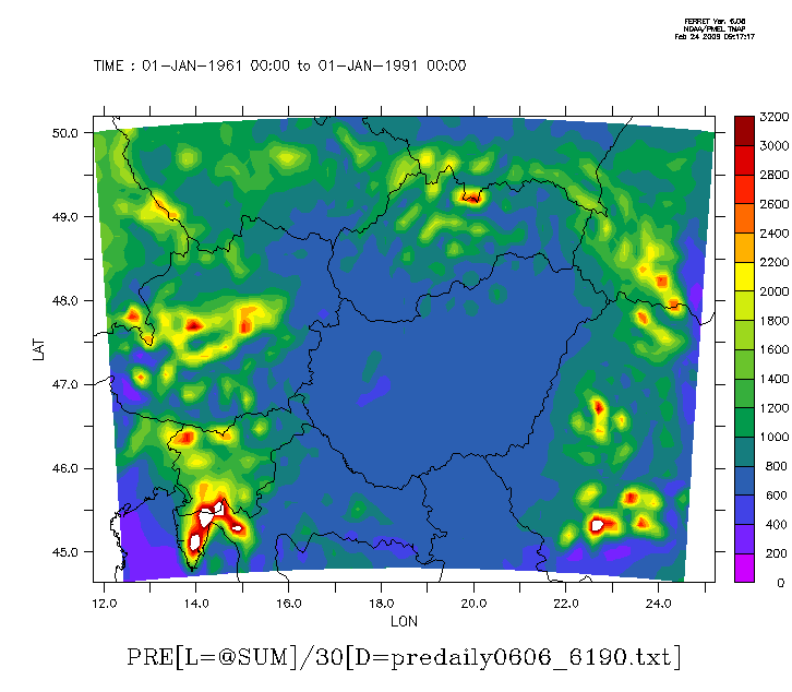
fill pre[l=@sum],lon[d=1],lat[d=1] !->I attach the picture of the original data (AA.lambert.gif) created with similarly to this command
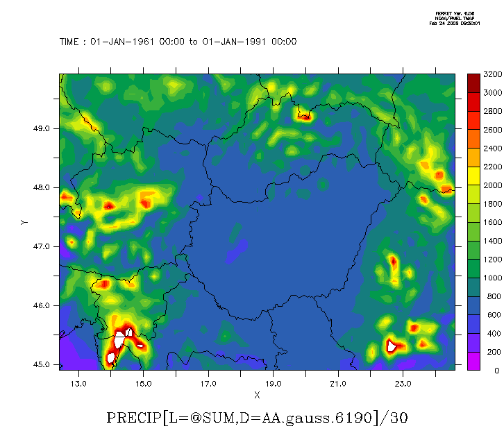
let precipG=scat2gridgauss_xy(xx1d,yy1d,pre,x[gx=lons],y[gy=lats],0.01,0.01,10,0)
fill precipG[l=@sum] !-> the data looks like this after the gaussian weightening (AA.gauss.gif)
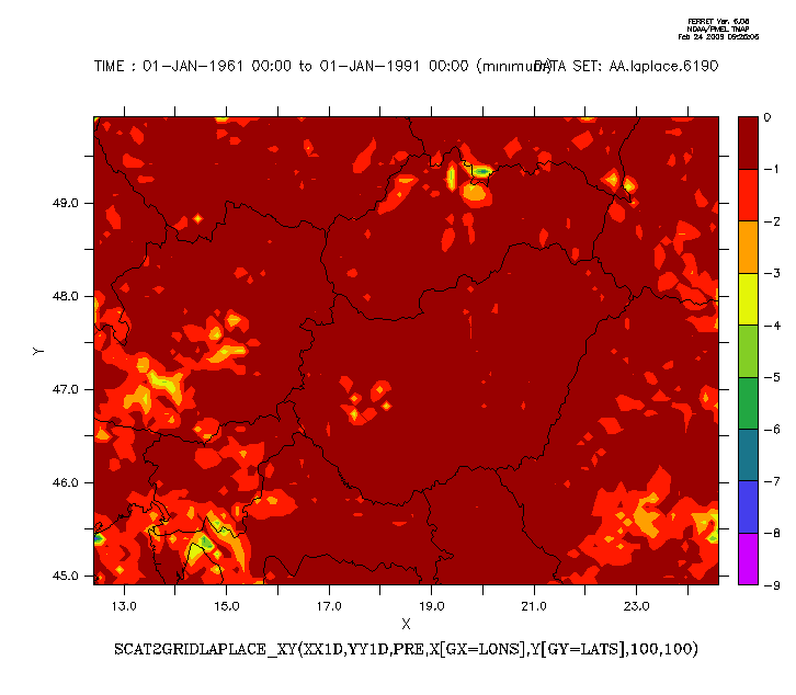
let precipL=scat2gridlaplace_xy(xx1D,yy1D,pre,x[gx=lons],y[gy=lats],100,100)
fill precipG[l=@sum] !-> the data looks like this after the laplace interpolation (AA.laplace.gif)
Now the data is on a lat-lon grid and both looks pretty the same, but if i count the minimum of the daily data the actual values are negative in the case of scat2gridlaplace. (i attach also the minimum value of the "laplace" data set. the two others dont have negative values larger than 0.05).
I know i should use the gaussian weightening and interpolation, but this bug/my fault still troubles me.
Thanks in advance,
Peter Szabo
Attachment:
AA.lambert.gif
Description: GIF image
Attachment:
AA.gauss.gif
Description: GIF image
Attachment:
AA.laplace.gif
Description: GIF image
Attachment:
AA.laplacemin.gif
Description: GIF image
[Thread Prev][Thread Next][Index]
Contact Us
Dept of Commerce /
NOAA /
OAR /
PMEL /
TMAP
Privacy Policy | Disclaimer | Accessibility Statement