If the behavior is happening only in GIF mode, the first place to look is to see whether there is an updated version of the gd library available. That is where the polygons get rendered onto the GIF bitmaps, and it sounds like the source of the problem here.
- Steve
Ansley Manke wrote:
Hi all,
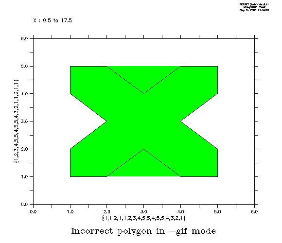
After working a bit on this off-line, we have determined that there is a long-standing bug in the Ferret graphics so that concave parts of polygons are incorrectly filled in when in -gif mode. For instance, this figure should be filled in only inside the shape, but the upper and lower concave parts get filled in. We'll see if we can find the cause of this.
Ansley
Yu, Hao-Cheng wrote:
Dear ferret users,
I try to use polygon command as land region to cover the interpolated variable to avoid misunderstanding.
The scripts works fine when I use normal mode (which shows on the screen with X env.)
However, when I try to produce gif file with gif mode (ferret -gif),
scripts still works fine but polygon cut unexpected regions in my plot.
I attach 2 figures to show the difference, first one is site1_01.gif which is produced by ferret -gif mode,
can easily found the salinity field was cut by polygon which suppose only to overwrite the land region.
normal.bmp is under normal mode ferret and extracted by print-screen.
Any suggestions?
Dan
--
Steve Hankin, NOAA/PMEL -- Steven.C.Hankin@xxxxxxxx
7600 Sand Point Way NE, Seattle, WA 98115-0070
ph. (206) 526-6080, FAX (206) 526-6744

"The only thing necessary for the triumph of evil is for good men
to do nothing." -- Edmund Burke