[Thread Prev][Thread Next][Index]
Re: [ferret_users] Projected data
Hi,
If you are not happy with the default result of the 3-argument versions
of the SHADE, FILL , and CONTOUR commands you can try the POLYGON
command in combination with the in ferret available map projections.
I have tested this on curvlinear model output where the cell-corners can
be used directly to define the polygons. However, it shouldn't be to
difficult to define pseudo-cells (I guess that is exactly what is done
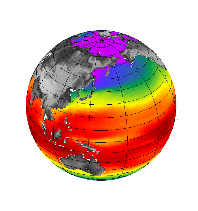
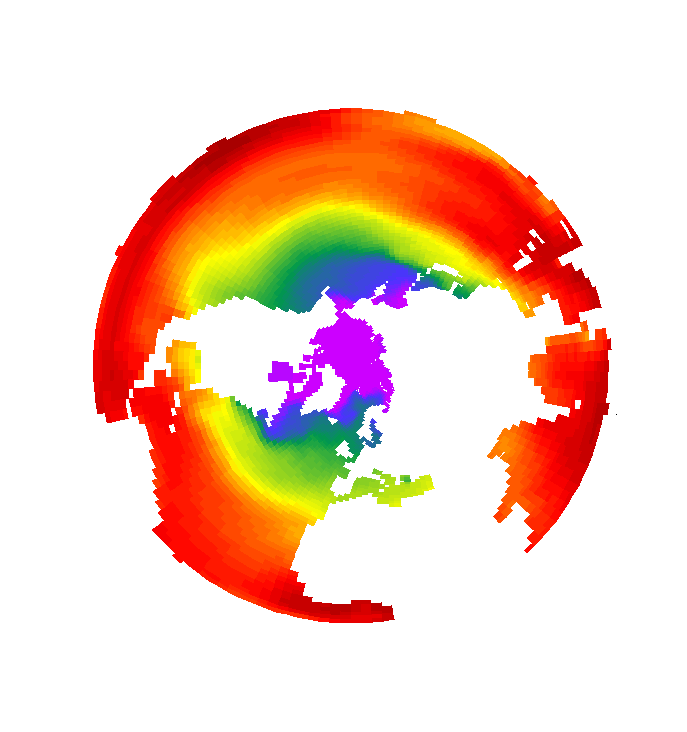
in the SHADE command) which suit your data. The attached figures crudely
illustrate how the result from the curvlinear output looks like.
Following steps are involved:
The polygon-coordinates need to be gathered in longitude and a latitude
matrices where the first dimension corresponds to the number of points
in each polygon and the second to your data dimension. It might be
neccessary to check and fix the longitude information of each polygon
(e.g. 179 and -179 -> 179 and 181 ect.). After calling the projection
script (e.g. go mp_orthographic 0 90) you need to set the variabels mp_x
and mp_y to your polygon longitude and latitude coordinates. Prior to
the call of the 3-argument version of the polygon command (e.g. polygon
x_page*mp_mask,y_page*mp_mask,sst) you might also want to call mp_aspect.
The drawback of this method is that not all projection scripts are
robust to user-defined mp_x,mp_y variables. With the exception of
mp_orthographic I'm still trying hard to get grid lines and land masks
right for the different projections.
Hope this helps...
Cheers, Ingo
Ansley Manke wrote:
Hi Tony,
You can plot this data with the curvilinear forms of the plotting
commands. The variables LONGITUDE and LATITUDE are 2-dimensional
curvilinear coordinate fields, so you can use this command to get the
correct longitude and latitude labellings
fill temperature, longitude, latitude
The fact that the SHOW GRID has the axes of the variables like
temperature labeled as longitude and latitude is misleading; the axes
are just indices 1 to 792 and the coordinates are in the curvilinear
coordinate variables. Look at the SHOW GRID output:
yes? show grid temperature
GRID GPI1
name axis # pts start end
X LONGITUDE 792 r 1E 72E(792)
Y LATITUDE 792 r 1N 792N
...
It has a latitude 1 N to 792N, and longitude 1 to 792 as well, which
is clearly incorrect. The curvilinear graphics commands require that
the X and Y axes of the variable field such as TEMPERATURE or
SALINITY, and the X and Y axes of the coordinates LONGITUDE and
LATITUDE agree and then it can draw the plot.
Ansley
Tony Jolibois wrote:
Hi all,
I have to plot some stereographic projected data (latitude 55N to
90N, projected in the netCDF), and I don't know how I can use it with
longitude and latitude (instead of x and y).
Here is the ferret command I use to produce the plot attached. The
axes are not good and I can not fill the land mask...
[console@rdp1-jaune arc]$ ferret -nojnl
NOAA/PMEL TMAP
FERRET v5.50
Linux 2.4.3-12smp - 01/15/03
12-Oct-05 09:40
yes? use mercatorPsy3v1R1v_arc_mean_20050923_R20051005.nc
yes? show data
currently SET data sets:
1> ./mercatorPsy3v1R1v_arc_mean_20050923_R20051005.nc (default)
name title I J
K L
TEMPERATURE
temperature 1:792 1:792
1:43 ...
SALINITY salinity 1:792 1:792
1:43 ...
U zonal velocity 1:792 1:792
1:43 ...
V meridian velocity 1:792 1:792
1:43 ...
KZ vertical eddy diffusivity 1:792 1:792
1:43 ...
LONGITUDE
longitude 1:792 1:792
... ...
LATITUDE latitude 1:792 1:792
... ...
SSH sea surface height 1:792 1:792
... ...
MLD temperature ocean mixed layer t 1:792 1:792
... ...
MLP density ocean mixed layer thick 1:792 1:792
... ...
TAUX windstress eastward Tx componen 1:792 1:792
... ...
TAUY windstress northward Ty compone 1:792 1:792
... ...
QTOT total net heat flux 1:792 1:792
... ...
EMP water flux 1:792 1:792
... ...
QSR surface downward solar heat flu 1:792 1:792
... ...
yes? show grid temperature
GRID GPI1
name axis # pts start end
X LONGITUDE 792 r 1E 72E(792)
Y LATITUDE 792 r 1N 792N
DEPTH DEPTH (m) 43 i- 0 5500
normal T
yes? set region/x=1:792/y=1:792/z=0
yes? fill/levels=(-3,15,0.2) temperature
Best regards,
Tony
--
Tony Jolibois
CLS - Direction Océanographie Spatiale
8-10 rue hermčs - 31520 Ramonville Saint-Agne
tjolibois@cls.fr
Tél : +33 (0) 561 393 797
Fax : +33 (0) 561 393 782
------------------------------------------------------------------------
[Thread Prev][Thread Next][Index]
Dept of Commerce /
NOAA /
OAR /
PMEL /
TMAP
Contact Us | Privacy Policy | Disclaimer | Accessibility Statement