|
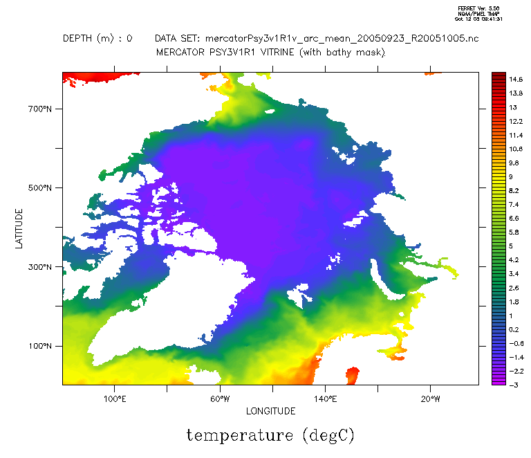
Hi all, I have to plot some stereographic projected data (latitude 55N to 90N, projected in the netCDF), and I don't know how I can use it with longitude and latitude (instead of x and y). Here is the ferret command I use to produce the plot attached. The axes are not good and I can not fill the land mask... [console@rdp1-jaune arc]$ ferret -nojnl NOAA/PMEL TMAP FERRET v5.50 Linux 2.4.3-12smp - 01/15/03 12-Oct-05 09:40 yes? use mercatorPsy3v1R1v_arc_mean_20050923_R20051005.nc yes? show data currently SET data sets: 1> ./mercatorPsy3v1R1v_arc_mean_20050923_R20051005.nc (default) name title I J K L TEMPERATURE temperature 1:792 1:792 1:43 ... SALINITY salinity 1:792 1:792 1:43 ... U zonal velocity 1:792 1:792 1:43 ... V meridian velocity 1:792 1:792 1:43 ... KZ vertical eddy diffusivity 1:792 1:792 1:43 ... LONGITUDE longitude 1:792 1:792 ... ... LATITUDE latitude 1:792 1:792 ... ... SSH sea surface height 1:792 1:792 ... ... MLD temperature ocean mixed layer t 1:792 1:792 ... ... MLP density ocean mixed layer thick 1:792 1:792 ... ... TAUX windstress eastward Tx componen 1:792 1:792 ... ... TAUY windstress northward Ty compone 1:792 1:792 ... ... QTOT total net heat flux 1:792 1:792 ... ... EMP water flux 1:792 1:792 ... ... QSR surface downward solar heat flu 1:792 1:792 ... ... yes? show grid temperature GRID GPI1 name axis # pts start end X LONGITUDE 792 r 1E 72E(792) Y LATITUDE 792 r 1N 792N DEPTH DEPTH (m) 43 i- 0 5500 normal T yes? set region/x=1:792/y=1:792/z=0 yes? fill/levels=(-3,15,0.2) temperature Best regards, Tony -- Tony Jolibois CLS - Direction Océanographie Spatiale 8-10 rue hermès - 31520 Ramonville Saint-Agne tjolibois@cls.fr Tél : +33 (0) 561 393 797 Fax : +33 (0) 561 393 782 |