Thank you very much for the insight into this problem. I'll see what, if anything, can be done at this end to get around it.
Regards,
John
Ansley Manke wrote:
Hi Jonn,
Bill's right, but the data's much wierder than that.
A good way to start diagnosing anything with curvilienar data is to look at the longitude and latitude fields separately, and the data without trying to use the curvilinear coordinates. The STAT command works well to get at what's in the coordinates and data fields.
set data "http://205.156.4.56/cgi-bin/nph-dods/st_johns/efdcgrid01.nc"
shade lon
shade lat
shade temp[k=1]
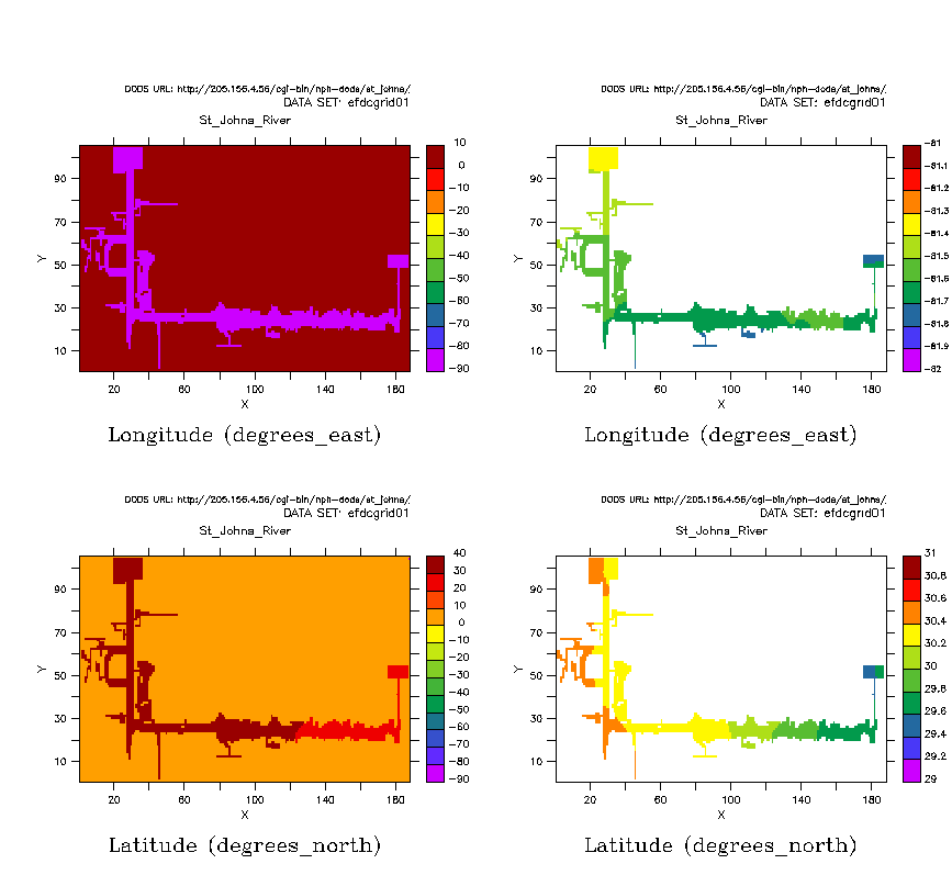
It looks like the data has a flag of 0 for all of the fields, except where there are grid locations where the idealized river is. (plot attached below, with first just SHADE LON and then with some levels specified so we can see what the values are)
The zero's are what is throwning off the curvilinear plotting algorithm. I'm not sure how we could get the method we have of visualizing curvilinear data to work at all with this sort of grid. We can't for instance just set the missing-value flags to zero, because the curvilinear method requires the longitude and latitude data to have no missing data.
Ferret would expect that the longitude and latitude fields be completely specified, and the data fields to have a flag where the data does not exist. I can't think of a way around this right off (but it's sure nice to have the data available via DODS so we can check out what's happening!)
Here is the script I used to get the plot below:
yes? set data "http://205.156.4.56/cgi-bin/nph-dods/st_johns/efdcgrid01.nc"
yes? cancel mode logo
yes? set view ul
yes? shade lon
yes? set view ur
yes? shade/lev=(-82,-81,0.1) lon
yes? set view ll
yes? shade lat
yes? set view lr
yes? shade/lev=(29,31,0.2) lat
John Schattel wrote:
Hi All,
I am trying to display some curvilinear model data and I am getting some unexpected results. You can see the results of a shade/title="Surface Currents" u,lon,lat command in the attached gif file (st_johns_river.gif). The data should have been for a stretch of the Eastern coast of Florida ( http://www.csc.noaa.gov/csp/images/fl_region.gif ). Does anyone have a suggestion on what might be going wrong or how to diagnose this problem. If you would like to see the netCDF data, it is available via the following DODS URL or I could e-mail it to you offline.
http://205.156.4.56/cgi-bin/nph-dods/st_johns/efdcgrid01.nc.info
In advance, thanks for any help you might provide.
John