[Thread Prev][Thread Next][Index]
Re: how to obtain geostrophic velocity
Hi
xuhuacheng,
I can see that you are using data producted by Collecte
Localisation Satellites
(.\hh_msla_oer_merged_h_15655.nc).
First, you are using Ferret for the analyse and visualisation of your
data.
Ferret is an OPeNDAP client, so you can use the AVISO OPeNDAP server to
access the data of Jason, T/P, Envisat, GFO etc... remotly
(http://opendap.aviso.oceanobs.com).
Another way to access these data is the AVISO Live Access Server
(http://las.aviso.oceanobs.com).
This software use Ferret as back-end application. You can use it to plot
rapidly the data, and use the different functionnality of the
LAS.
For the scientific question, aviso@cls.fr is the good adress, and this
mail is in copy.
If you have ohter question, do not hesitate.
Best regards, Tony Jolibois
~~~~~~~~~~~~~~~~~~~~~~~~~~~~~~~~~
Tony Jolibois
CLS, Direction Ocťanographie Spatiale
Tel: (+33) (0) 561 393 797
Internet:
http://www.cls.fr
~~~~~~~~~~~~~~~~~~~~~~~~~~~~~~~~~
At 15:25 19/11/2003 +0800, you wrote:
Hi ferreters!
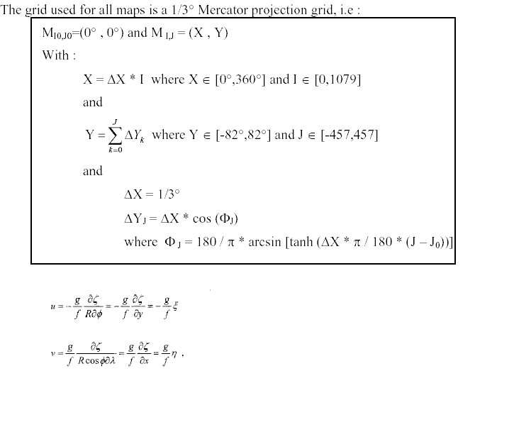
I would like to use T/P altimeter data to obtain geostrophic velocity.The following are the introduction of the data and the formula to be used.
yes? show data
currently SET data sets:
1> .\hh_msla_oer_merged_h_15655.nc (default)
name title I J K L
LATLONMIN
Latitude/Longitude of south/oue 1:2 ... ... ...
LATLONSTEP
latitude/longitude steps 1:2 ... ... ...
GRID_0001
H 1:1080 1:915 ... ...
How can I use the data to obtain the geostrophic velocity.Any information will be highly appreciated.
Thanks,
xuhuacheng
[Thread Prev][Thread Next][Index]
Dept of Commerce /
NOAA /
OAR /
PMEL /
TMAP
Contact Us | Privacy Policy | Disclaimer | Accessibility Statement