TROPICAL ATMOSPHERE-OCEAN (TAO) PROGRAM
FINAL
CRUISE INSTRUCTIONS
FOR
KA-03-05 (GP5-03-KA)
August 21 –
September 27, 2003
TAO Program Director
Dr. Michael J. McPhaden
PMEL, TAO Project Office
7600 Sand Point Way NE
Seattle, WA 98115
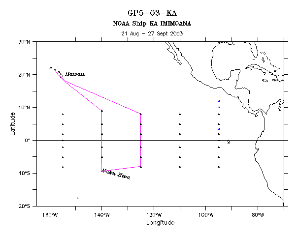
Area: Equatorial Pacific
Itinerary:
KA-03-05 Honolulu, HI dep. 21 August 2003
Honolulu, HI arr. 27 September 2003
CRUISE DESCRIPTION
General guidelines are contained in the TAO Program Standard Operating
Instructions for NOAA Ship KA’IMIMOANA dated June 28, 2002.
Cruise Objective and Plan:
The objective of this cruise is the maintenance of the TAO Array along
the 125°W and 140°W meridians. The scientific
complement will embark in Honolulu, Hawaii and depart aboard KA’IMIMOANA
on 21 August, 2003 to commence operations as listed in Appendix A. A brief stop is scheduled in Nuku Hiva,
Marquises during the period September 12 – 15.
The exact dates of this inport may change due to weather and operations
schedules. A test mooring is planned
for deployment at the 5N 140W site.
This mooring will three different types of anemometers for comparison. There are no subsurface sensors. After completion of operations, KA’IMIMOANA
will proceed to Honolulu, Hawaii arriving on or about September 27, 2003. All
dates and times referred to in these cruise instructions are in Pacific
Standard Time (PST).
PMC Operations: TAO Operations
Manager:
Larry Mordock LCDR
Chris Beaverson, NOAA
NOAA/MOC-Pacific (MOC-P1x3) PMEL,
TAO, R/E/PM
1801 Fairview Ave. East 7600
Sand Point Way NE
Seattle, WA 98102-3767 Seattle, WA
98115-0070
(206) 553-4764 (206)
526-6403
Larry.Mordock@noaa.gov Chris.Beaverson@noaa.gov
1.0 PERSONNEL
1.1 CHIEF SCIENTIST AND
PARTICIPATING SCIENTISTS:
Chief Scientist: Patrick
A’Hearn
The Chief Scientist is authorized to revise or alter the scientific
portion of the cruise plan as work progresses provided that, after consultation
with the Commanding Officer, it is ascertained that the proposed changes will
not: (1) jeopardize the safety of personnel or the ship; (2) exceed the overall
time allotted for the cruise; (3) result in undue additional expenses; (4) alter
the general intent of these instructions.
A list of participating scientists follows. All participating scientists will submit a medical history form
and be medically approved before embarking.
Participating Scientists
Name Sex Nationality Affiliation
1. Patrick A’Hearn M USA NOAA/PMEL
2. Brian Powers M USA NOAA/PMEL
3. James Patton M USA Univ.
South Florida (USF)
4. Xuewu (Sherwood) Liu M USF USF
5. Renate Bernstein F USA USF
6. Jon Pompa (Hono to Nuku
Hiva) M USA UCSD
7. John Kermond M USA NOAA/OGP
8. Tetsuro Isono M Japan JAMSTEC
9. Teacher at Sea ? ?
10. Tom Nolan (Nuku Hiva to Hono) M USA NASA/JPL
11. Charles Johnson-Gutter M USA Bloomsburg
2.0
OPERATIONS
Mooring Operations are scheduled to be conducted as shown in Appendix
A. Operations will be conducted from 8°N - 125°W to 8°S - 125°W and 5°S - 140°W to 9°N 140°W . A short stop in Nuku Hiva, Marquises is
planned on or about September 12 – 15.
The exact dates may change depending on weather and the progress of the
cruise. A test mooring is planned for
deployment at 5N 140W. This mooring
will have no subsurface sensors. The
following mooring operations are anticipated, though the work may be changed by
direction of the Chief Scientist, in consultation with the Commanding Officer.
Location Mooring Type Operation
8°N 125°W ATLAS II - Taut Repair, wind swap
5°N 125°W ATLAS II - Taut Recover/Deploy
2°N 125°W ATLAS II - Taut Recover/Deploy, Insert,
fairings
0°N 125°W ATLAS II - Taut Recovery/Deploy, Insert,
fairings, CO2 mods
2°S 125°W ATLAS II - Taut Visit.
5°S 125°W ATLAS II - Taut Visit.
Stop in Nuku Hiva
5°S 140°W ATLAS II - Taut Recovery/Deploy
2°S 140°W ATLAS II - Taut Visit.
0° 140°W ATLAS II - Taut Recovery/Deploy. Insert, fairings, sontek, CO2 mods.
0° 140°W Subsurface ADCP Recovery/Deploy
2°N 140°W ATLAS II - Taut Recover/Deploy, Insert, fairings
5°N 140°W ATLAS II - Taut Repair, dump RAM, check rain
Test Mooring Deploy wind test mooring
(no subsurface)
9°N 140°W ATLAS II - Taut Visit
2.01 CTD
At a minimum, 1000 meter CTD casts shall be conducted at each mooring
site between 12° N and 8° S for sensor inter‑comparison purposes. As time permits, additional or deeper CTD's should be conducted
whenever addition of the CTD’s will not impact scheduled mooring work. For example, if the ship would arrive at the
next mooring site in the middle of the night, it is preferable to do CTD’s on
the way, rather than remain hove to waiting for daylight. Another example would be when mooring
operations are significantly ahead of schedule. Beyond those at mooring sites, CTD's should be conducted in the
following order of priority:
- 1000m CTD’s at one degree latitude intervals between 12° N and 8° S, along the
ship's trackline.
- Extend 1000m CTD’s at mooring sites to a minimum of 3000m or a maximum
depth of 200m from bottom. 4 to 6 deep
casts are optimal, occurring at the beginning and end of the cruise as well as
at both equatorial sites.
- 1000m CTD’s every one‑half degree of latitude between 3°N and 3°S
- Additional calibration CTD’s to be determined by Chief Scientist.
USF and UCSD personnel will be available to assist the survey technician
with CTD casts and running salinities.
2.02 Monterey Bay Aquarium
Research Institute (MBARI) Chlorophyll and Nutrients
Phytoplankton biomass work consisting of chlorophyll extractions and
nutrient samples will collected from CTD rosette at 0, 10, 25, 40, 60, 100, 150
and 200m. The total volume used from each bottle, including rinses is
approximately one liter; except for the surface bottle, which will require
approximately three liters. This
requires use of the sink/bench area of the wet lab for filtration purposes. Chlorophyll samples will be measured
on-board using a bench-top fluorometer which will require use of the
salinometer room. Nutrient samples (sea
water) will be stored in the science hold and off-loaded upon return.
The barnacle observer will conduct this work.
2.03 Bloomsburg University Barnacle Census
Barnacles will be
collected in accordance with TAO Standard Operating Instructions. Sea spiders may also be collected in a
similar manner by the barnacle observer on behalf of Lanna Cheng of
Scripps. The sea spiders will be
preserved in 70% ethanol. A pre and
post cruise inventory of Hazardous Materials (Hazmat) brought aboard and
offloaded from the ship will be given to the Chief Scientist and Commanding
Officer. All Hazardous Materials will
be properly labeled as to content, Hazmat classification and cruise number.
2.04 Atlantic Oceanographic and
Meteorological Laboratory (AOML) Surface Drifters
The Global
Drifter Center at NOAA/AOML requests drifter deployments on an ancillary basis.
The drifters are small, easily deployed
devices which are tracked by Argos and provide Sea Surface Temperature (SST)
and mixed layer current information.
The global array of drifters provides SST ground truth for NOAA's polar
orbiting satellite AVHRR SST maps. They
also provide data for use in operational meteorological and ocean models.
14 AOML drifters are scheduled at the
following positions:
125 W: deploy at 5N, 3N, 2N, equ, 2S, 3S, 5S
140 W:
deploy at 5S, 3S, 2S, equ, 2N, 3N, 5N
The deployments
should have little or no impact upon primary ship operations. Questions should be directed to:
Craig Engler,
Global Drifter Center, NOAA/AOML
305‑361‑4439
(office) or 305‑361‑4392 (fax)
Craig.Engler@noaa.gov or http://www.aoml.noaa.gov/
2.05 Scripps Institution of Oceanography (SIO)
SOLO Deep Ocean Drifters
9 SOLO drifters are scheduled for deployment on this cruise. The drifters are being shipped to Honolulu directly from Scripps. The 9 planned float deployment locations are given below. Deployment positions can be shifted in either direction along the ship track to avoid mooring or station locations, meal times etc. If any drifter should fail its initialization, then omit the final location(s). The drifters may be deployed in any order except for S/N 2227 which should be deployed first. (16.5 N, 146.25 W).
Deployments are scheduled along the ship’s trackline at approximately:
16.5
N, 146.25 W
10
N, 130.5 W
0,
125 W
5.5
S, 125 W
8
S, 130 W
4
S, 140 W
1
S, 140 W
1
N, 140 W
4
N, 140 W
Questions should be directed to:
Dean Roemmich
Scripps Institution of Oceanography ‑ University of California, San Diego
(858) 534-2307 droemmich@ucsd.edu
Backup contact: Glenn Pezzoli, (858) 534-1139, gpezzoli@ucsd.edu
2.06 Dissolved inorganic carbon analysis
(DIC)
A 0.5 liter sea water sample from surface CTD casts will be taken and stored for later dissolved inorganic carbon analysis. Sample jars and mercury chloride solution will be provided by Scripps institute of Oceanography. Samples for GP3 and GP4 will be stored on board until the ship returns to Honolulu. Cathy Cosca from PMEL will ship the samples to Scripps when she comes to work on the underway Co2 system in August. It is anticipated that the survey technician, together with USF personnel will take the samples. A small bench-top drill press will be shipped to the ship to assist with the bottle capping process.
The contacts for this project are:
Dr. Andrew Dickson Dr. Richard Feely
Scripps Institution of Oceanography NOAA/PMEL
University of California, San Diego 7600 Sand Point Way NE
Room 203 -- Vaughan Hall Seattle, Washington 98115
8675 Discovery Way
La Jolla, CA 92037 Tel (206) 526-6214
Tel: (858) 534-2582
Email: adickson@ucsd.edu Richard.A.Feely@noaa.gov
2.07 Underway CO2 and pH analysis
(University of South Florida)
The purpose of the USF work
is development of precise, accurate, simple, robust and inexpensive CO2-system measurement procedures for use in global CO2-system investigations on NOAA vessels. Our
collaborative work with NOAA is designed to assess the accuracy, precision and
overall performance of USF systems relative to the systems used by NOAA
personnel over the past fifteen years.
Two SEAS systems for in situ
pH measurements: SEAS will be lowered in the water column to about 300 meters
at a rate of 6 meters per minute to collect pH profile continuously.
Associated
components:
1. Two SEAS,
2. Two Battery Packs.
3. Two CTDs,
4. Fluorometer,
5. Two cables.
6. Deployment frame,
7. Tools.
CO2 Analysis System for
automatic shipboard measurements of pCO2, pH and DIC. The system will use the
same seawater line that is used by NOAA personnel for shipboard pCO2 measurements.
Associated
components:
8. Constant temperature water baths (two Lauda E100)
9. Liquid delivery system (five peristaltic pumps)
10. Equilibrators (LCW cells)
11. Main instrument(s) (Electronic Controllers, Relay
boards, USB hub, 3 spectrophotometers, light sources), Computer. (one instrument
system plus a backup system)
12. CTD for measurement of seawater salinity and
temperature in the flowing seawater line.
Chemicals: Standard
solutions with fixed alkalinity made of Na2CO3 and NaHCO3 and indicator dyes
(BCP and Phenol Red) 2N phosphoric acid for acidification.
Lab space requirements are
as follows: Space for (a) a water circulator and space for a 20 x 20 x15
(width/width/height) frame to hold the pH/DIC/pCO2 instrument on floor. A table providing workspace for
(a) two computers and (b) SEAS (during preparation for deployment) (c)
preparation
Winch time is requested for
pH sensor deployments. Most deployments will be to depths of 200 to 250 meters.
Deployments will take about one and one-half hours. Deployment frequency will
depend on availability of wire time and the success of the deployments. Deployments will be made on a time
available basis, not to interfere with buoy operations or the PMEL CTD program.
2.08 Wirewalker
Experiment (UCSD)
The Wirewalker is a
profiling instrument platform suspended from a 15” surface float by a 30 meter
length of 3/16” steel wire with a weight at the lower end. The wire moves
vertically with the surface wave motion, allowing the mechanically ratcheting
instrument platform to profile. The instruments on the wirewalker are
internally recording and do not require cables to the ship. However, the system
is tethered to the ship or a buoy to keep it from drifting away.
The whole assembly weighs
less than 100lbs so it can be launched easily by two people. An outboard boom
or overhead block would be helpful for line handling but is not absolutely
necessary. Deployment is completed several steps. The instrument platform is
first clipped to the weight end of the wire. It is swung overboard and the wire
is run out to its full length. The float is attached to the top of the wire and
sent overboard. Finally, a tether from the float is attached to a mooring.
The plan is to deploy the
Wirewalker opportunistically from the ship during non-transit periods. It can
be tethered to the ship if not under
way, or it can be tethered to a buoy. Ideally, longer deployments are desirable
because they will provide longer continuous data sets. This is secondary,
however, to the main goal of gaining knowledge of how these devices could be
deployed in proximity to deep-sea moorings to provide near-surface data. We
hope to deploy in high currents to test its ability to deal with shear and also
to observe its behavior while tethered to a mooring.
This work is planned for the
first leg of the trip (21 August to ~11 September) Honolulu to Nuku Hiva) with
the understanding that the Nuku Hiva port call is weather dependent.
Between Wirewalker
deployments, the accompanying student can help with other scientific activities
as needed.
Deployments of the
Wirewalker will be made during the non-transit time when operations will not
interfere with TAO maintenance activities. Launches and recoveries will take
10-20 minutes if from the ship and longer if there is a small boat ride to tether
off of a TAO mooring.
The launch and recovery of a
wirewalker usually requires two people. A “volunteer” will be requested to
assist.
An area to set up a laptop
for data download and processing.
A small workbench for working
on the wirewalkers and associated instruments (potentially the same place as
the computer desk),
A space to store 3 (3’ x 2’
x 2’) packing crates.
Lithium Batteries: Approx.
30 standard 9v.
Equipment
|
Item |
Dimensions |
Weight |
|
2 Wirewalkers |
42” x 20” x 20” |
25 lb. ea. |
|
2 Wirewalker cables |
16” x12” x 12” |
30 lb. ea. |
|
Laptop computer |
|
5 lb. |
|
Toolbox of tools and
assorted hardware |
24” x 12” x12” |
50 lb. |
|
2 temperature/depth
recorders |
16” x 3” dia. |
2 lb.ea. |
|
Lithium batteries for the
instruments |
|
5 lb. total |
|
Spool of line |
6” x 10” dia |
4 lb. |
|
Approximate total with
packing crates |
|
300 lb. |
3.0 Hazardous Materials
The
Chief Scientist is responsible for the proper and safe storage of scientific
hazardous material and complying with NC Instruction 6280B, Hazardous Materials
and Hazardous Waste Policy, Guidance, and Training, dated May 8, 1991. This
includes the requirement for the Chief Scientist to remove all scientific team
hazardous materials and waste at the end of the cruise.
3.1 Ancillary Projects Hazardous Materials
1.
Acetone 12
Liters MBARI
2.
Hydrochloric Acid (HCL) 6
Liters MBARI
3.
Formalin (50% stored in Wx deck Hazmat locker) 32
Liters Bloomsburg
(diluted to 5% working solution for wet
lab use)
4. Ethanol (70%) 2
Liters Bloomsburg
5. Mercuric Chloride solution (saturated with
30 grams) 400 ML Scripps/PMEL
6. Mercuric Chloride powder 30
g Scripps/PMEL
7. Phosphoric acid 500
ML USF
8. Lithium batteries 30
x 9v UCSD
Appendices:
B. Trackline
C. Mooring Equipment
Weight List